Items Similar to Antique World Map with Astronomical Spheres by Pierre Mortier, Amsterdam, c.1700


Want more images or videos?
Request additional images or videos from the seller
1 of 10
Antique World Map with Astronomical Spheres by Pierre Mortier, Amsterdam, c.1700
$877.30
$1,169.7325% Off
£654.60
£872.8025% Off
€735
€98025% Off
CA$1,223.35
CA$1,631.1325% Off
A$1,340.62
A$1,787.4925% Off
CHF 700.10
CHF 933.4625% Off
MX$16,110.54
MX$21,480.7225% Off
NOK 8,752.44
NOK 11,669.9225% Off
SEK 8,254.94
SEK 11,006.5925% Off
DKK 5,595.67
DKK 7,460.9025% Off
About the Item
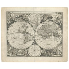
Antique World Map with Astronomical Spheres by Pierre Mortier, Amsterdam, circa 1700
This fascinating antique world map titled "Carte générale du monde, ou description du monde terrestre & aquatique" (General Map of the World, or Description of the Terrestrial and Aquatic World) was published by Pierre Mortier in Amsterdam around 1700. It is a richly detailed and ambitious map engraved on Mercator’s projection, combining geographic knowledge with early scientific and cosmographic understanding. The map includes titles in both French and Dutch and was engraved by Jan van Luchenburg. It was originally published in Mortier’s famous biblical atlas, "Historie des Ouden en Nieuwen Testaments."
The map depicts the continents with a mixture of contemporary accuracy and lingering cartographic myths. California is prominently shown as an island, and a speculative Northwest Passage is marked by a dotted line linking the Detroit d'Anian to Button’s Bay, west of Hudson Bay. In North America, a large fictitious lake appears as the source of the Rio Grande (R. de Nort), and the Great Lakes region is labeled as "Mer Douce" but remains incomplete. A small portion of New Zealand is indicated in the Pacific, reflecting early sightings. Australia’s outline is still very much in flux—its northern coast is connected to New Guinea, while Van Diemen’s Land (Tasmania) and other southern fragments appear disjointed. The northeastern tip of Asia is compressed and includes the speculative Cap de Glaces described by Nicolaas Witsen.
One of the most distinctive features of this map is the row of five celestial and hemispheric diagrams above the map. These illustrations show various scientific and biblical concepts, including the phases of the moon, day and night, the Great Flood, and representations of the Western and Eastern hemispheres. This integration of theological, astronomical, and geographic knowledge makes the map an extraordinary example of Enlightenment-era worldview.
Condition report:
Good condition overall. There is some visible restoration along the lower margin and central folding line. The map is printed on strong paper and has a blank verso. The impression remains sharp, and the engraving retains fine detail. Please review the image closely for specific condition aspects.
Framing tips:
This map would look striking in a dark wood or ebony frame with a wide ivory or parchment-colored mat to draw out the fine black-and-white engraving. Museum-quality glass is recommended to protect the detailed work and ensure longevity. Its balance of historical geography and scientific illustration makes it an ideal centerpiece for a study, library, or gallery focused on exploration, theology, or the history of science.
- Dimensions:Height: 16.93 in (43 cm)Width: 20.08 in (51 cm)Depth: 0 in (0.01 mm)
- Materials and Techniques:Paper,Engraved
- Place of Origin:
- Period:
- Date of Manufacture:circa 1700
- Condition:Good condition overall. There is some visible restoration along the lower margin and central folding line. The map is printed on strong paper and has a blank verso. The impression remains sharp, and the engraving retains fine detail.
- Seller Location:Langweer, NL
- Reference Number:Seller: BG-12063-11stDibs: LU3054329621822
About the Seller
5.0
Recognized Seller
These prestigious sellers are industry leaders and represent the highest echelon for item quality and design.
Platinum Seller
Premium sellers with a 4.7+ rating and 24-hour response times
Established in 2009
1stDibs seller since 2017
2,655 sales on 1stDibs
Typical response time: <1 hour
- ShippingRetrieving quote...Shipping from: Langweer, Netherlands
- Return Policy
Authenticity Guarantee
In the unlikely event there’s an issue with an item’s authenticity, contact us within 1 year for a full refund. DetailsMoney-Back Guarantee
If your item is not as described, is damaged in transit, or does not arrive, contact us within 7 days for a full refund. Details24-Hour Cancellation
You have a 24-hour grace period in which to reconsider your purchase, with no questions asked.Vetted Professional Sellers
Our world-class sellers must adhere to strict standards for service and quality, maintaining the integrity of our listings.Price-Match Guarantee
If you find that a seller listed the same item for a lower price elsewhere, we’ll match it.Trusted Global Delivery
Our best-in-class carrier network provides specialized shipping options worldwide, including custom delivery.More From This Seller
View AllAntique Map of the World on Mercator's Projection, 1788
Located in Langweer, NL
Antique map titled 'Kaart van de Geheele Wereld (..)'. Uncommon small world map on Mercator's projection. Nice detail of the islands throughout the wor...
Category
Antique Late 18th Century Maps
Materials
Paper

$716 Sale Price
20% Off
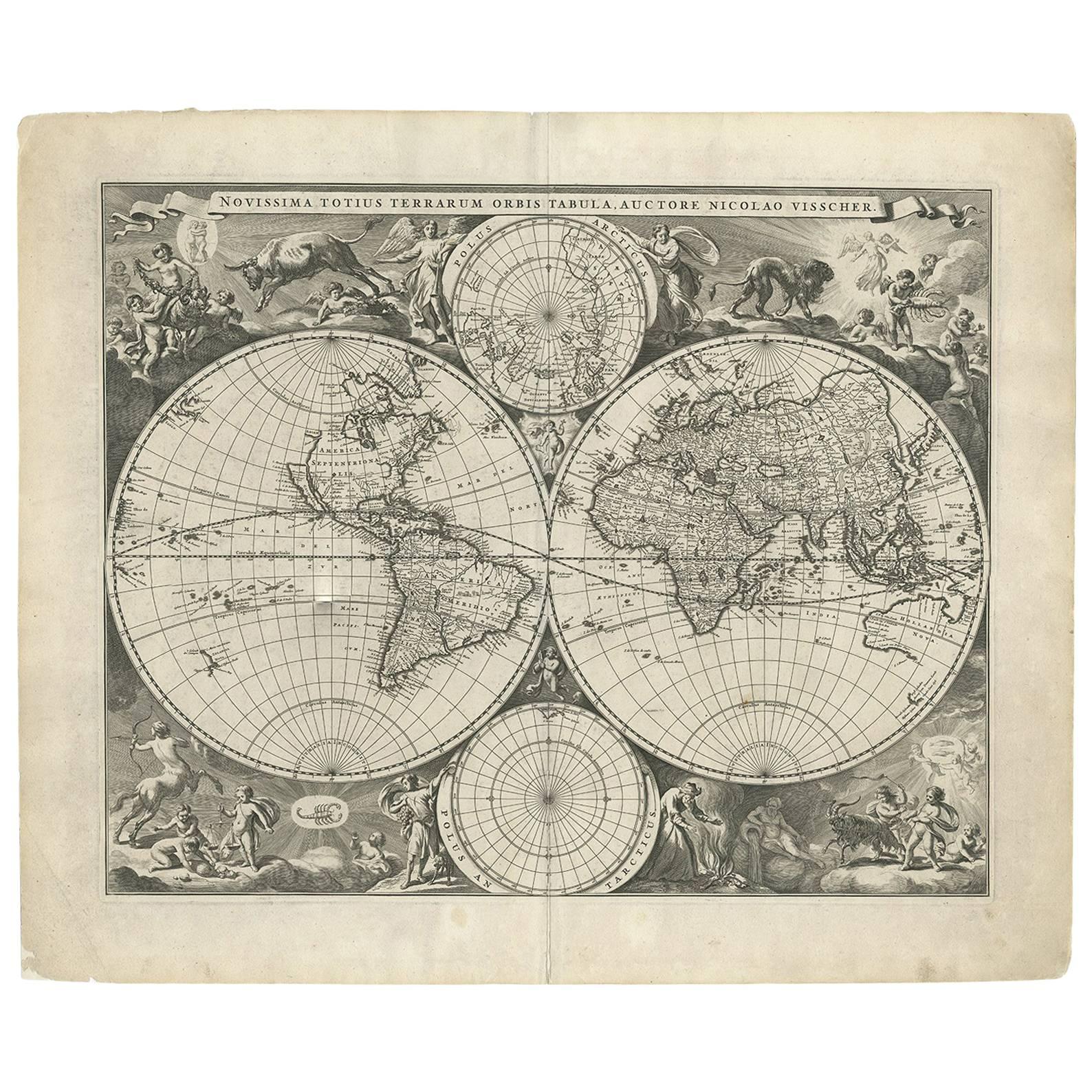
Gorgeous Antique World Map by the Dutch Mapmaker Visscher, published circa 1679
Located in Langweer, NL
Antique map titled 'Novissima Totius Terrarum Orbis Tabula, Auctore Nicolao Visscher'. Gorgeous example of Nicholas Visscher's World map, which appeared...
Category
Antique Late 17th Century Dutch Maps
Materials
Paper
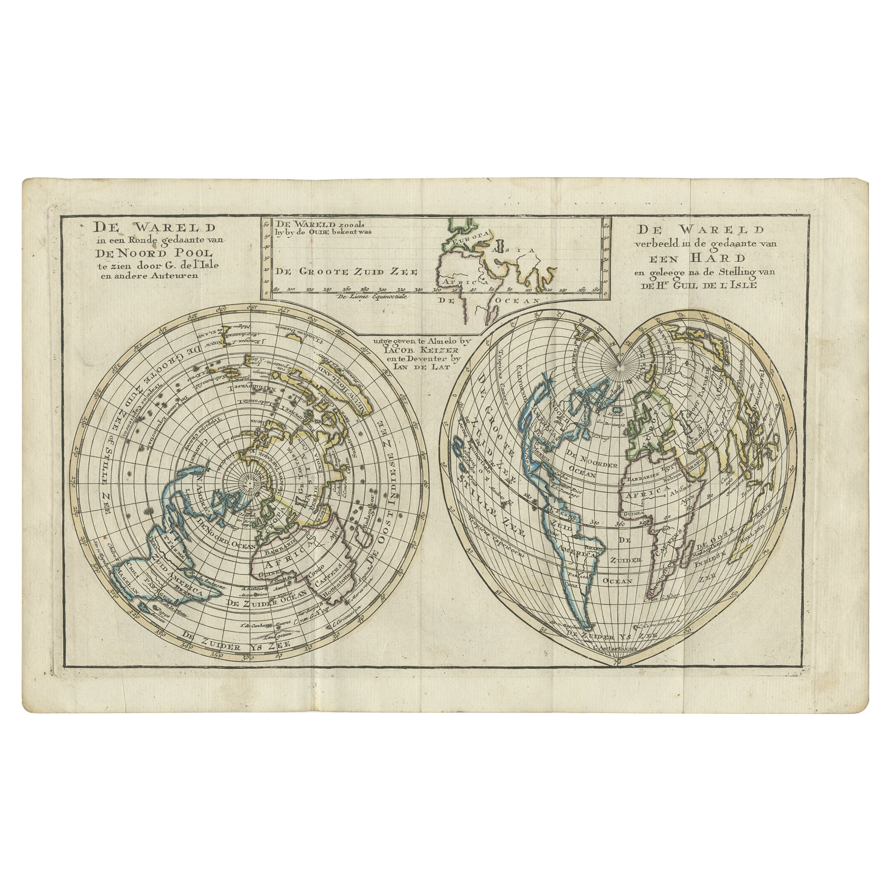
Antique Map of the World in Hemispheres by Keizer & de Lat, 1788
Located in Langweer, NL
Antique map titled 'Schuine Ronde Aard-Bolle waar van 't Middelpunt is Amsterdam (..)'. Interesting double hemisphere world map on polar projections. In North America, there is a large Island of California. Australia and New Zealand are shown with incomplete coastlines. The map contains six smaller astronomical...
Category
Antique Late 18th Century Maps
Materials
Paper

$477 Sale Price
20% Off
Antique Map of the World with California as an Island, 1788
Located in Langweer, NL
Description: Antique map titled 'De wareld in een ronde gedaante van de Noord Pool te zien - De Wareld verbeeld in de gedaante van een hard'. This interesting composition contains three world maps on the sheet. At left is a northern projection showing all the landmasses. At right is a cordiform projection (heart-shaped). At top is a map of the world as known to the ancients. Both the polar and cordiform projections show California as an island...
Category
Antique 1780s Maps
Materials
Paper

$620 Sale Price
20% Off
Very Attractive Antique Map of the World as Planisphere, Shows Cook's Voyages
Located in Langweer, NL
Antique map titled 'Chart of the World, according to Mercators Projection'. This world map shows the various discoveries of Captain James Cook during his 3 voyages between 1768 and 1780, and the English and French Explorers who followed immediately thereafter, including Vancouver and La Perouse. This edition of the map is significantly revised from the editions issued immediately after the official report of Cook's Voyages were integrated into the map, showing better detail in New Zealand, Australia, the Northwest Coast of America and North East coast of Asia, along with Greenland. A new large lake also appears for the first time in the Western part of North America, shortly before the commencement of the Lewis...
Category
Antique Late 18th Century Maps
Materials
Paper

$1,342 Sale Price
25% Off
Free Shipping
Very Decorative Original Antique Map of the World, Published in France in c.1780
By Rigobert Bonne
Located in Langweer, NL
Antique map titled 'L'Ancien Monde Et Le Nouveau en Deux Hemispheres' - Double hemisphere map of the World, showing the contemporary geographical...
Category
Antique 18th Century Maps
Materials
Paper

$735 Sale Price
20% Off
You May Also Like
Original Antique Map of The World by Thomas Clerk, 1817
Located in St Annes, Lancashire
Great map of The Eastern and Western Hemispheres
On 2 sheets
Copper-plate engraving
Drawn and engraved by Thomas Clerk, Edinburgh.
Published by Mackenzie And Dent, 1817
...
Category
Antique 1810s English Maps
Materials
Paper

Original Antique Map of The World by Dower, circa 1835
Located in St Annes, Lancashire
Nice map of the World
Drawn and engraved by J.Dower
Published by Orr & Smith. C.1835
Unframed.
Free shipping
Category
Antique 1830s English Maps
Materials
Paper

Original Antique Map of The Western Hemisphere by Dower, circa 1835
Located in St Annes, Lancashire
Nice map of the Western Hemisphere
Drawn and engraved by J.Dower
Published by Orr & Smith. C.1835
Unframed.
Free shipping
Category
Antique 1830s English Maps
Materials
Paper

1864 Johnson's Map of the World on Mercator's Projection, Ric.B009
Located in Norton, MA
An 1864 Johnson's map of
the World on Mercator's Projection
Ric.b009
About this Item
"This antique map came from Johnson's New Illustrated (Steel Plate) Family Atlas, publ...
Category
Antique 19th Century Dutch Maps
Materials
Paper

Antique Map of Eastern Hemisphere from the collection of Thierry Despont
Located in New York, NY
Designed by Enrico Bonetti (E. Bonatti) and published by Francesco Vallardi Editore. Based on an earlier map by Evangelista Azzi (Ev. Azzi). Labeled as such at bottom edge of map.
T...
Category
Antique Late 19th Century Italian Maps
Materials
Canvas, Wood

Original Antique Map of The Eastern Hemisphere by Dower, circa 1835
Located in St Annes, Lancashire
Nice map of the Eastern Hemisphere
Drawn and engraved by J.Dower
Published by Orr & Smith. C.1835
Unframed.
Free shipping
Category
Antique 1830s English Maps
Materials
Paper

More Ways To Browse
17th Century Dutch Wood Frames
Phases Of The Moon
Black And White Engraving
Antique Hudson Bay
17th Century World Map
Maps Of New Mexico
Antique Map Of Argentina
Antique Map Of Colombia
Cornwall Map
Early Texas Furniture
Iraq Map
James Cook Map
Kentucky Antiques
Map Of Mexican California
Montreal Map
Mughal Map
Napoleon Map
Rand Mcnally Vintage Maps