Items Similar to Antique Zoological and Botanical Chart of the World – Decorative Map, 1884


Video Loading
Want more images or videos?
Request additional images or videos from the seller
1 of 12
Antique Zoological and Botanical Chart of the World – Decorative Map, 1884
$382.43
£283.11
€320
CA$529.18
A$583.32
CHF 305.22
MX$7,157.19
NOK 3,842.14
SEK 3,593.01
DKK 2,436.48
About the Item
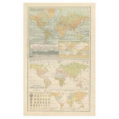
Antique Zoological and Botanical Charts of the World – Black’s Atlas, 1884
This double plate from the New and Revised Edition of Black’s General Atlas of the World, published in Edinburgh in 1884, presents a rich scientific overview of the natural world. It combines zoological and botanical information in a global context, reflecting the Victorian fascination with classification, exploration, and natural history.
The upper chart, titled “Zoological Chart of the World Showing the Distribution of Some of the Principal Members of the Animal Kingdom,” maps out the regions where different mammals and birds are found. It includes an inset showing the distribution of principal bird groups and a vertical diagram illustrating how animal life varies with elevation, from lowland species to those inhabiting alpine environments.
The lower chart, “Chart of the World Showing the Distribution of the Principal Plants,” applies a similar approach to vegetation. It identifies the world’s dominant plant regions, from tropical forests to temperate grasslands and alpine flora. Insets highlight the vertical distribution of plants and the global cultivation of key economic crops such as tea, sugar, coffee, and cotton.
Together, these charts provide a striking synthesis of zoological and botanical knowledge as understood in the late 19th century. They not only reveal the geographic spread of animals and plants but also the growing European interest in global trade commodities and the ecological variations of climate and altitude.
For collectors, this plate is a fine example of Victorian scientific mapping, combining careful engraving with pastel hand-coloring. It illustrates the interconnectedness of natural history, geography, and commerce during the high point of exploration and empire.
Condition report:
Very good condition. Original coloring remains clear and attractive. Light marginal toning with a mild age patina, consistent with atlas maps of this date. Small tear in lower border, outside image. Sold without frame.
Framing tips:
This sheet is well suited to a double-window archival mat, allowing both the zoological and botanical charts to be displayed in balance. A light ivory or pale green mat pairs nicely with the pastel color palette, while a dark oak or black frame creates an elegant contrast. For an academic or library-style display, a simple gilt frame enhances its 19th-century scholarly character.
Technique: Engraving with original hand coloring
Maker: Black’s General Atlas, Edinburgh, 1884
- Dimensions:Height: 17.84 in (45.3 cm)Width: 12.29 in (31.2 cm)Depth: 0.01 in (0.2 mm)
- Materials and Techniques:
- Place of Origin:
- Period:
- Date of Manufacture:1884
- Condition:Very good condition. Original coloring remains clear and attractive. Light marginal toning with a mild age patina, consistent with atlas maps of this date. Small tear in lower border, outside image.
- Seller Location:Langweer, NL
- Reference Number:Seller: BG-13601-3-31stDibs: LU3054346496932
About the Seller
5.0
Recognized Seller
These prestigious sellers are industry leaders and represent the highest echelon for item quality and design.
Platinum Seller
Premium sellers with a 4.7+ rating and 24-hour response times
Established in 2009
1stDibs seller since 2017
2,615 sales on 1stDibs
Typical response time: <1 hour
- ShippingRetrieving quote...Shipping from: Langweer, Netherlands
- Return Policy
Authenticity Guarantee
In the unlikely event there’s an issue with an item’s authenticity, contact us within 1 year for a full refund. DetailsMoney-Back Guarantee
If your item is not as described, is damaged in transit, or does not arrive, contact us within 7 days for a full refund. Details24-Hour Cancellation
You have a 24-hour grace period in which to reconsider your purchase, with no questions asked.Vetted Professional Sellers
Our world-class sellers must adhere to strict standards for service and quality, maintaining the integrity of our listings.Price-Match Guarantee
If you find that a seller listed the same item for a lower price elsewhere, we’ll match it.Trusted Global Delivery
Our best-in-class carrier network provides specialized shipping options worldwide, including custom delivery.More From This Seller
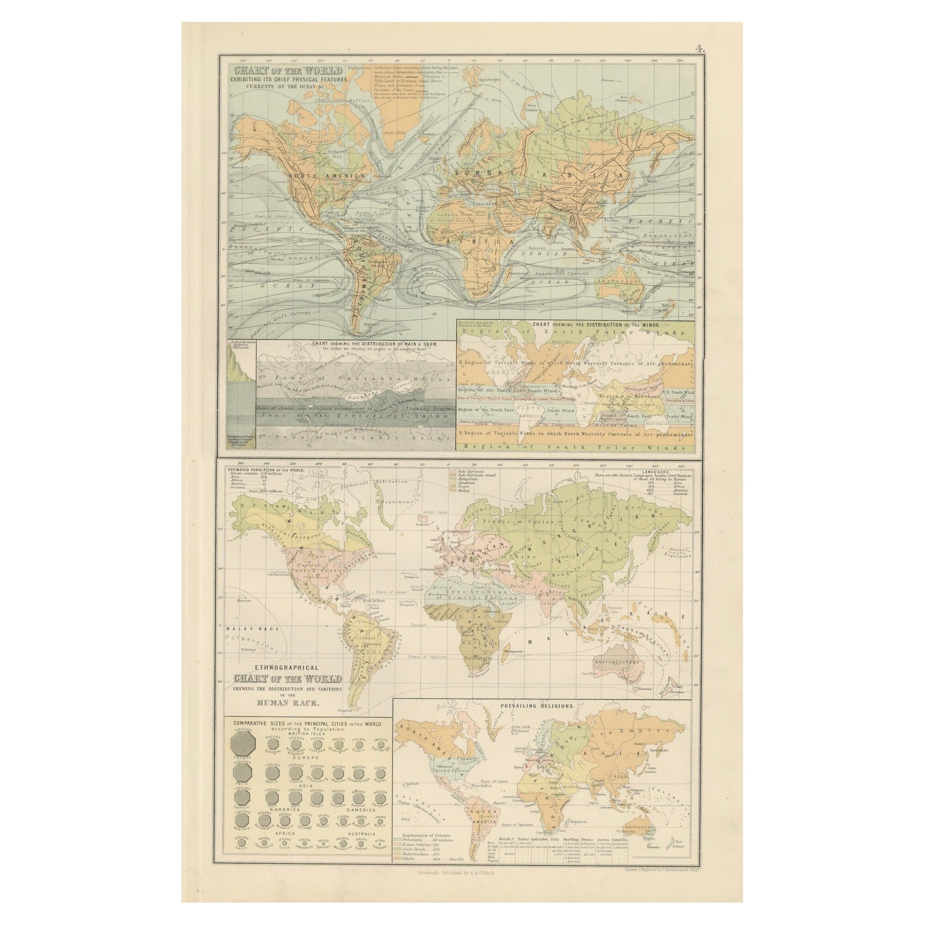
View AllAntique Charts of the World – Physical Features and Ethnographical Map, 1884
Located in Langweer, NL
Antique Charts of the World – Physical Features and Ethnographical Map, 1884
Description:
This fascinating double plate from the New and Revised Edition of Black’s General Atlas of ...
Category
Antique 1880s Scottish Maps
Materials
Paper
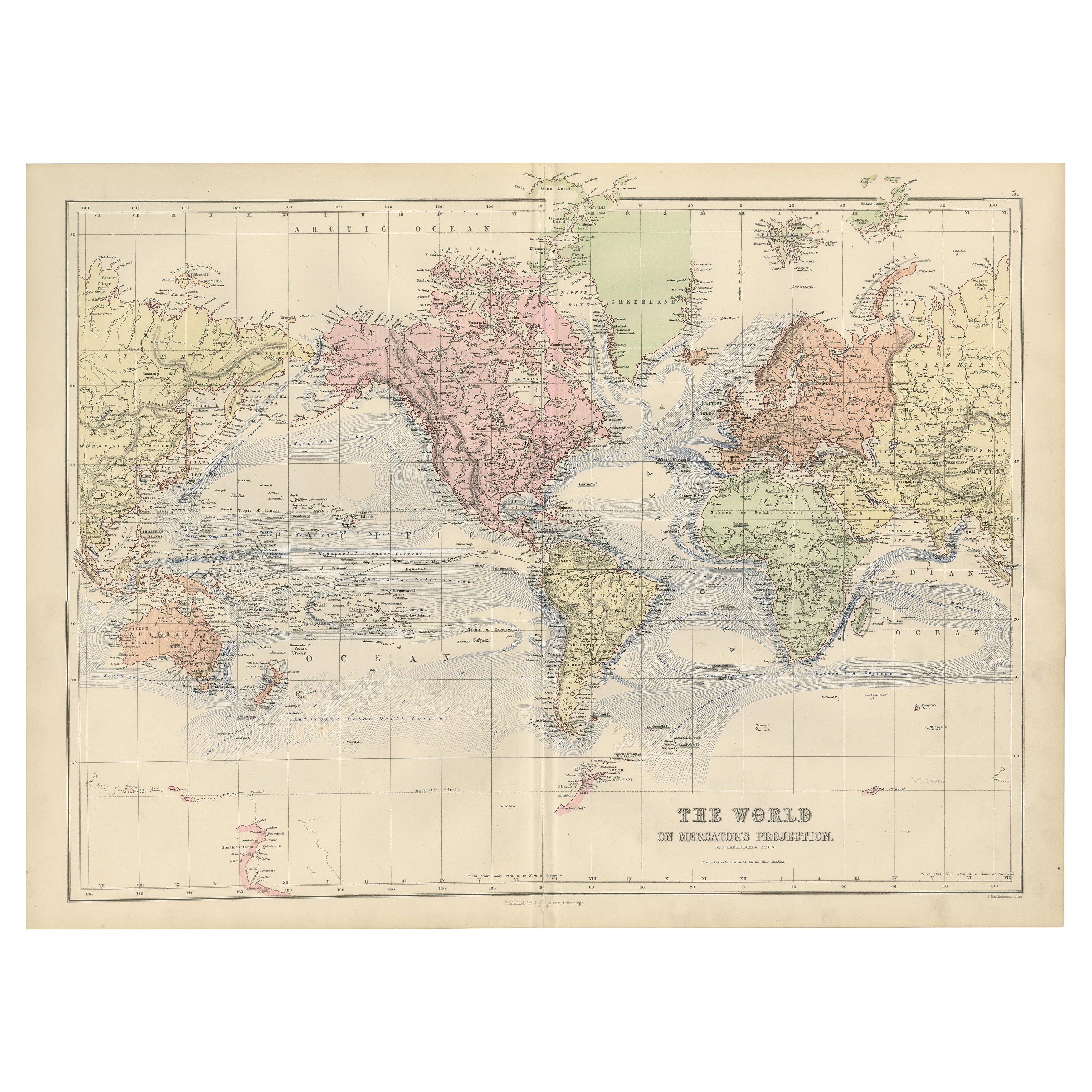
1884 Antique Decorative World Map – Mercator Projection, Victorian Era Print
Located in Langweer, NL
Antique World Map on Mercator’s Projection – Black’s Atlas, 1884
This finely engraved and colored map, titled The World on Mercator’s Projection, was published in the New and Revise...
Category
Antique 1880s Scottish Maps
Materials
Paper

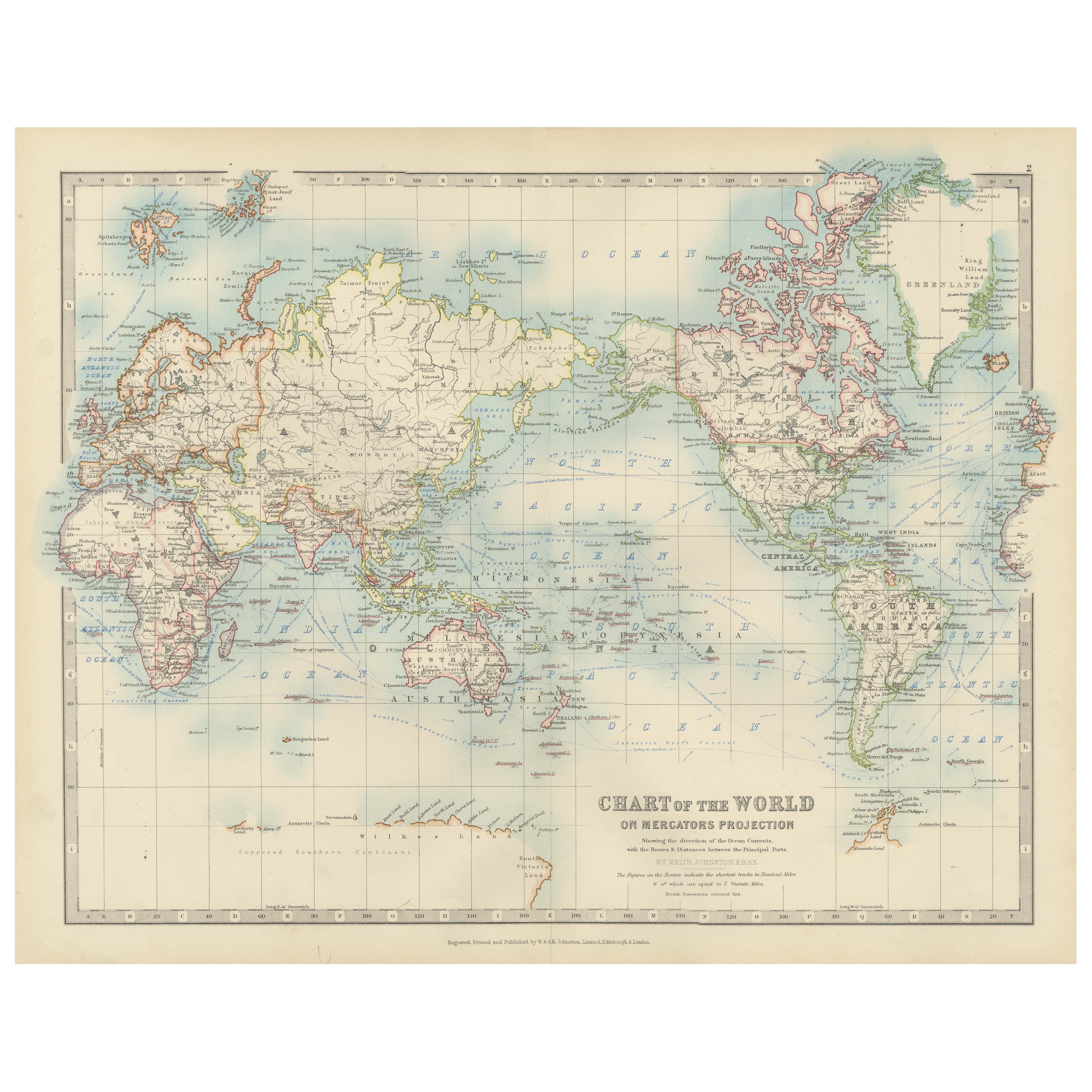
Antique World Map on Mercator's Projection, Ocean Currents and Trade Routes 1903
Located in Langweer, NL
Title: Antique World Map on Mercator's Projection, 1903, Showing Ocean Currents and Trade Routes
Description:
This antique map, titled "Chart of the World on Mercator's Projection,"...
Category
Early 20th Century Maps
Materials
Paper

Antique Map of The World in Hemispheres on Various Projections, 1882
Located in Langweer, NL
This stunning 1882 'Antique Map of The World in Hemispheres' showcases an exquisite blend of cartographic precision and artistic elegance. Crafted under the watchful eye of W.G. Blac...
Category
Antique 1880s Maps
Materials
Paper

$267 Sale Price
20% Off
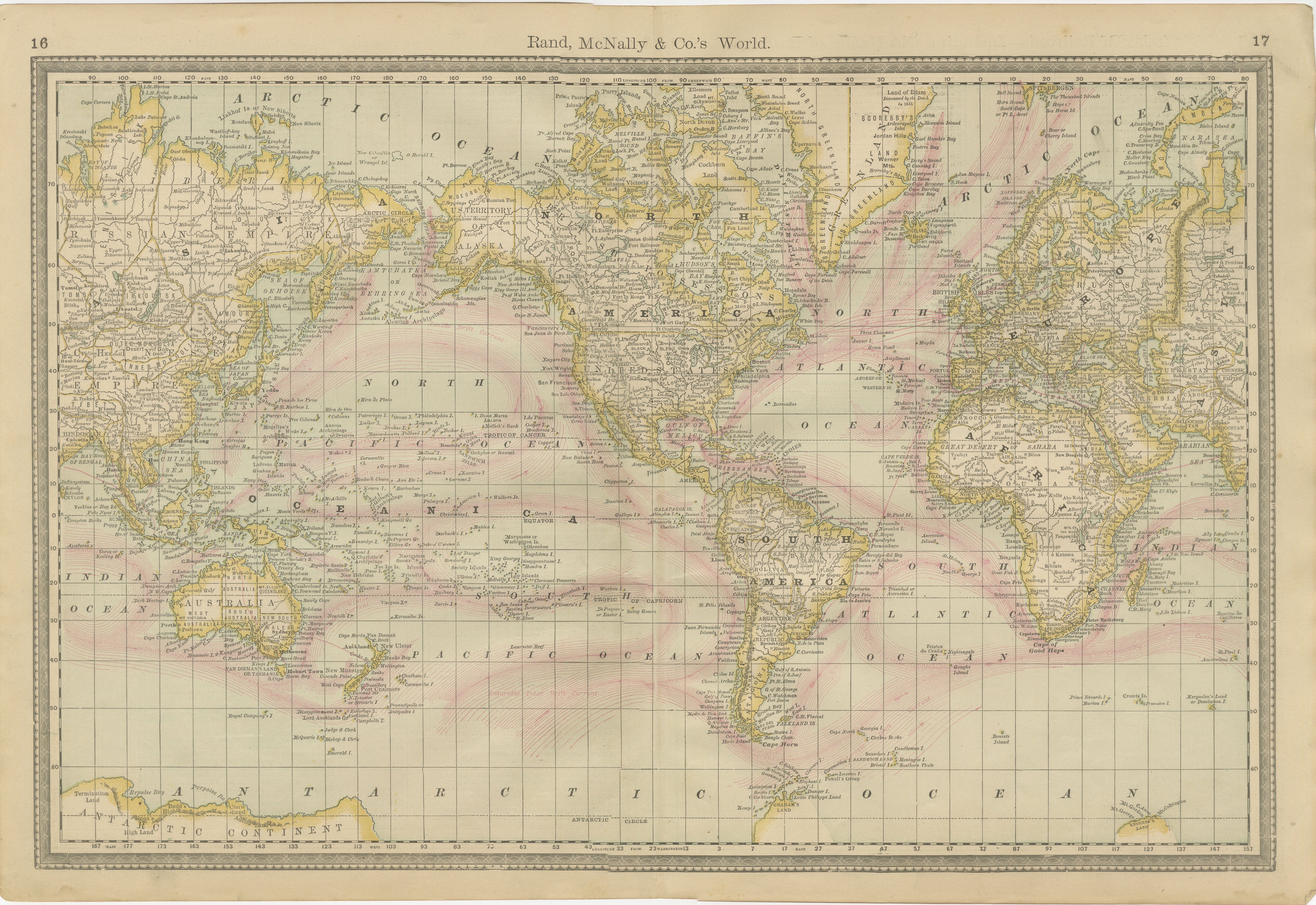
World Antique Map c.1888 – Rand McNally, Continents & Territories
Located in Langweer, NL
Antique Map of Mexico – Rand McNally, circa 1888
This antique map titled “Rand, McNally & Co.’s Mexico” was published around 1888 and depicts Mexico in the late 19th century, a peri...
Category
Antique Late 19th Century American Maps
Materials
Paper
Antique Map of the World Showing the Distribution of Plants and Minerals, 1872
Located in Langweer, NL
Antique map titled 'Johnson's World showing the distribution of the Characteristic Forest Trees (..)'. Original world map showing the distribution o...
Category
Antique Late 19th Century Maps
Materials
Paper

$191 Sale Price
20% Off
You May Also Like
Original Antique Map of The World by Dower, circa 1835
Located in St Annes, Lancashire
Nice map of the World
Drawn and engraved by J.Dower
Published by Orr & Smith. C.1835
Unframed.
Free shipping
Category
Antique 1830s English Maps
Materials
Paper

Original Antique Map of The World by Thomas Clerk, 1817
Located in St Annes, Lancashire
Great map of The Eastern and Western Hemispheres
On 2 sheets
Copper-plate engraving
Drawn and engraved by Thomas Clerk, Edinburgh.
Published by Mackenzie And Dent, 1817
...
Category
Antique 1810s English Maps
Materials
Paper

Large Original Antique Map of The World, Fullarton, C.1870
Located in St Annes, Lancashire
Great map of the World. Showing both hemispheres
From the celebrated Royal Illustrated Atlas
Lithograph. Original color.
Published by Fullarton, Edinburgh, C.1870
Unframed.
Rep...
Category
Antique 1870s Scottish Maps
Materials
Paper

Large Original Antique Map of the World, Fullarton, circa 1870
Located in St Annes, Lancashire
Great map of the World.
From the celebrated Royal Illustrated Atlas
Lithograph. Original color.
Published by Fullarton, Edinburgh, circa 1870.
Unframed.
Category
Antique 1870s Scottish Maps
Materials
Paper

Large Original Vintage Map of North America, circa 1920
Located in St Annes, Lancashire
Great map of North America
Original color. Good condition
Published by Alexander Gross
Unframed.
Category
Vintage 1920s English Edwardian Maps
Materials
Paper

1864 Original illustrated planisphere - World Map - Geography
Located in PARIS, FR
Immerse yourself in the epic journey of the past with the Illustrated Historical Planisphere of 1864 by Charpentier! 🗺️ This cartographic treasure transports you through the intrica...
Category
1860s Prints and Multiples
Materials
Linen, Lithograph, Paper
