Items Similar to Balkan Convergence: A Map of Turkey and Greece with the Balkan States, 1882

Want more images or videos?
Request additional images or videos from the seller
1 of 6
Balkan Convergence: A Map of Turkey and Greece with the Balkan States, 1882
About the Item
This map, "TURKEY AND GREECE including ROUMANIA, SERVIA, BULGARIA, BOSNIA & MONTENEGRO," extracted from Blackie & Son's 1882 atlas, captures the complex political and geographical landscape of Southeastern Europe and the Eastern Mediterranean during the late 19th century.
The map spans the region from the Ionian Sea and the Adriatic Coast in the west to the Sea of Marmara and the Aegean Sea in the east. It encompasses a significant period in Balkan history, where the decline of Ottoman authority gave rise to the emergence of new nation-states. This transition is illustrated through the detailed demarcation of political boundaries, with each state and province colored distinctly to differentiate the territories.
The Balkan Peninsula's rugged terrain, marked by the Dinaric Alps and the Balkan Mountains, is intricately depicted, reflecting the challenging geography that has long influenced the region's history and culture. The map also meticulously charts the extensive river systems, such as the Danube, which have been crucial for trade and strategic movements across Europe.
Major cities, such as Constantinople (Istanbul), Athens, Sofia, Belgrade, and Bucharest are highlighted, underlining their historical importance as centers of commerce, culture, and administration. The map's detail extends to smaller towns and villages, providing a sense of the population distribution across the region.
Railways and roads are also noted, indicating the developing infrastructure that was transforming the landscape and connectivity of the Balkan states at the time.
This map is not only a geographical representation but also a historical document. It captures a moment of transformation in the Balkans, reflecting the shifting powers and the rise of nationalism that would eventually lead to the region's profound changes in the 20th century. The cartographic detail offers a window into the era's statecraft, exploration, and the enduring legacy of empire.
- Dimensions:Height: 22.45 in (57 cm)Width: 14.97 in (38 cm)Depth: 0 in (0.02 mm)
- Materials and Techniques:
- Period:
- Date of Manufacture:1882
- Condition:Good condition, folding line in the middle. The outer borders are slightly discolored due to age, but not the image. This map is ideal for framing. Study the image carefully.
- Seller Location:Langweer, NL
- Reference Number:
About the Seller
5.0
Platinum Seller
These expertly vetted sellers are 1stDibs' most experienced sellers and are rated highest by our customers.
Established in 2009
1stDibs seller since 2017
1,919 sales on 1stDibs
Typical response time: <1 hour
- ShippingRetrieving quote...Ships From: Langweer, Netherlands
- Return PolicyA return for this item may be initiated within 14 days of delivery.
More From This SellerView All
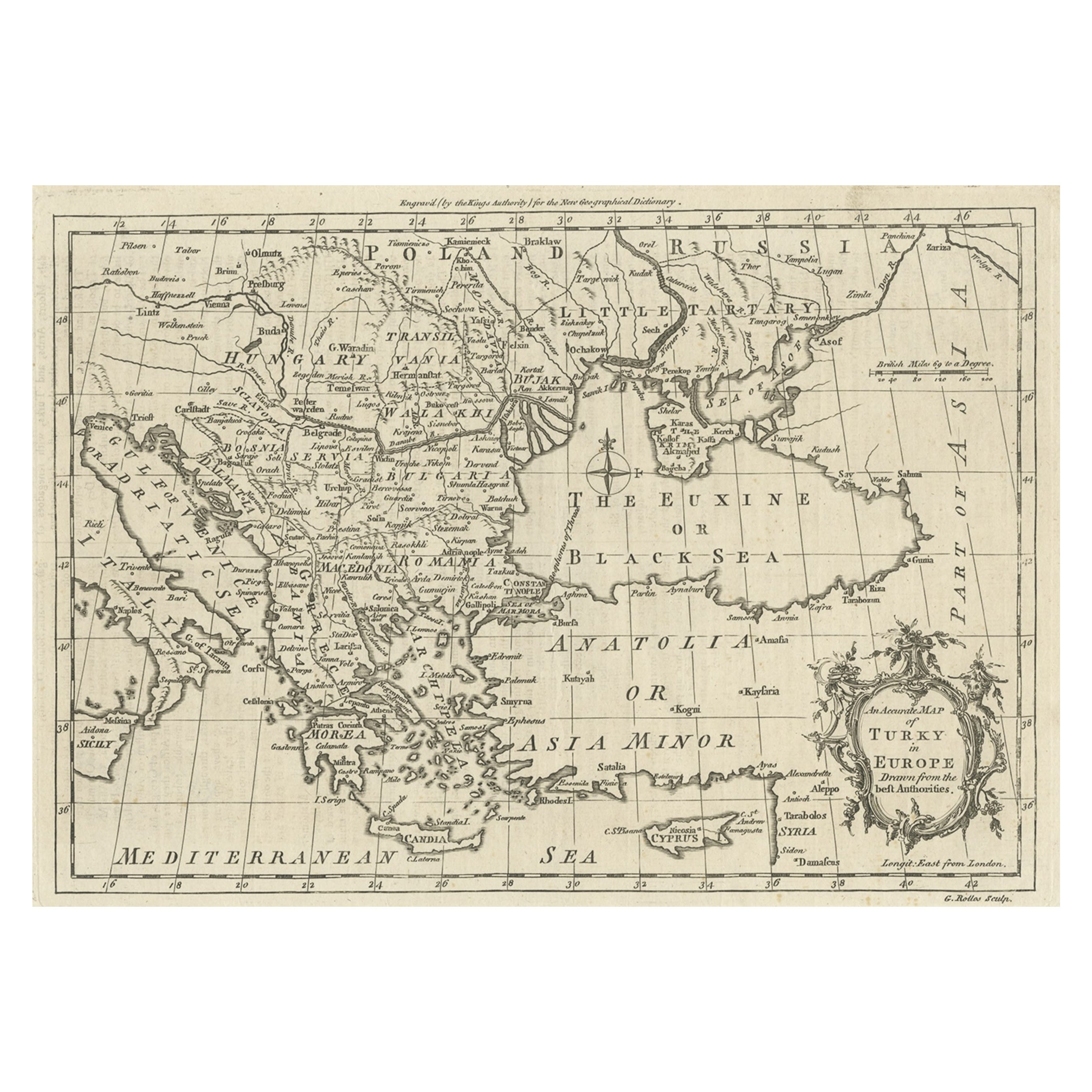
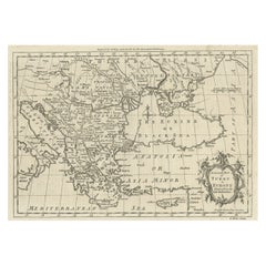
- Map of the Ottoman Empire in Europe, incl. the Balkans, Greece & Turkey, c.1760Located in Langweer, NLAntique map Turkey titled 'An Accurate Map of Turky in Europe drawn from the best Authorities'. Map of the Ottoman Empire in Europe, the Balkans, Greece, and Turkey in Europe. Engr...Category
Antique 1760s Maps
MaterialsPaper
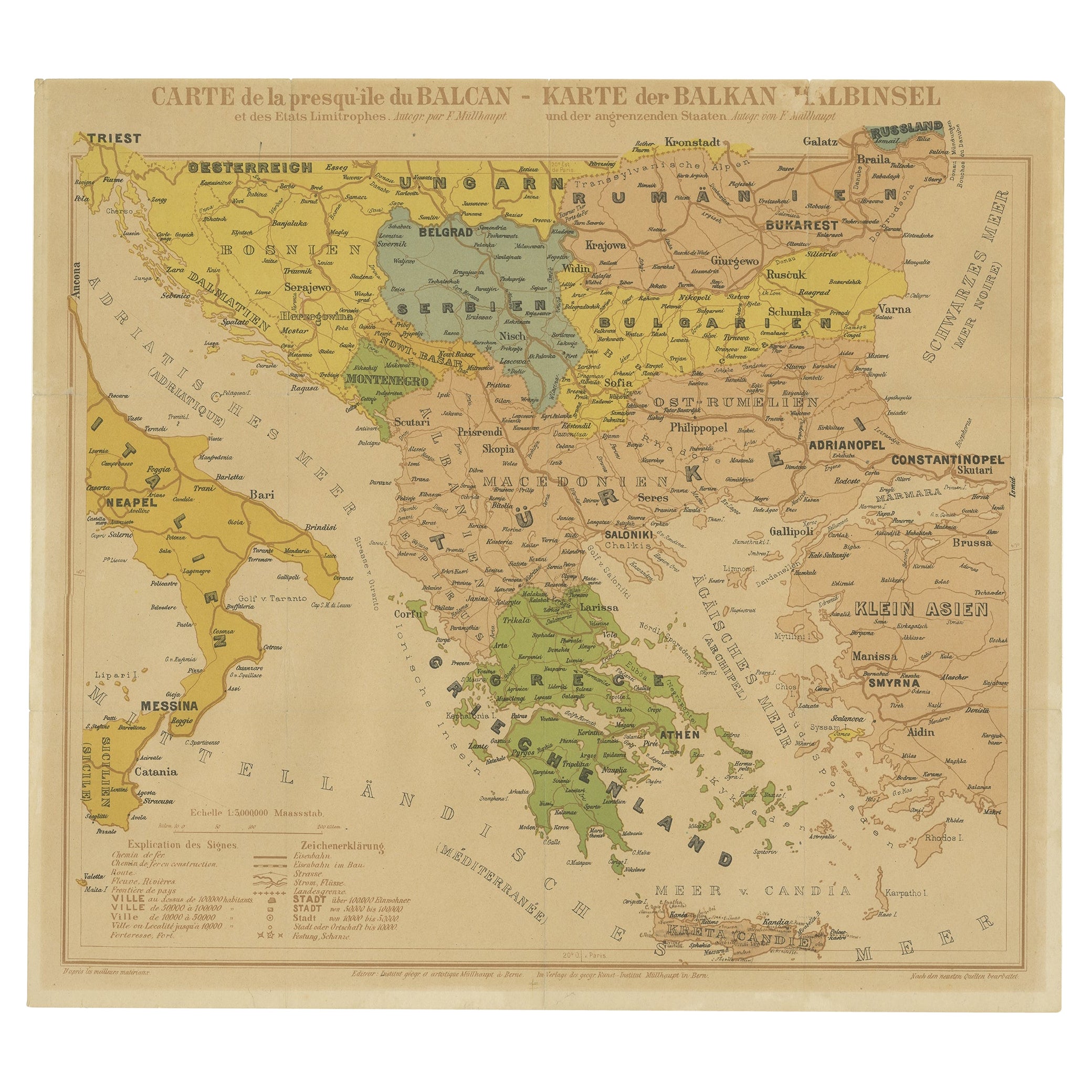
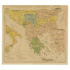
- Old Map of the Balkans Incl Greece, Turkey, Serbia, Montenegro, Bulgaria, C.1900Located in Langweer, NLAntique map titled 'Carte de la presqu-île du Balcan - Karte der Balkan Halbinsel'. Original antique map of the Balkans including Greece, Turkey, Serbia, Montenegro, Bulgaria and...Category
Antique Early 1900s Maps
MaterialsPaper
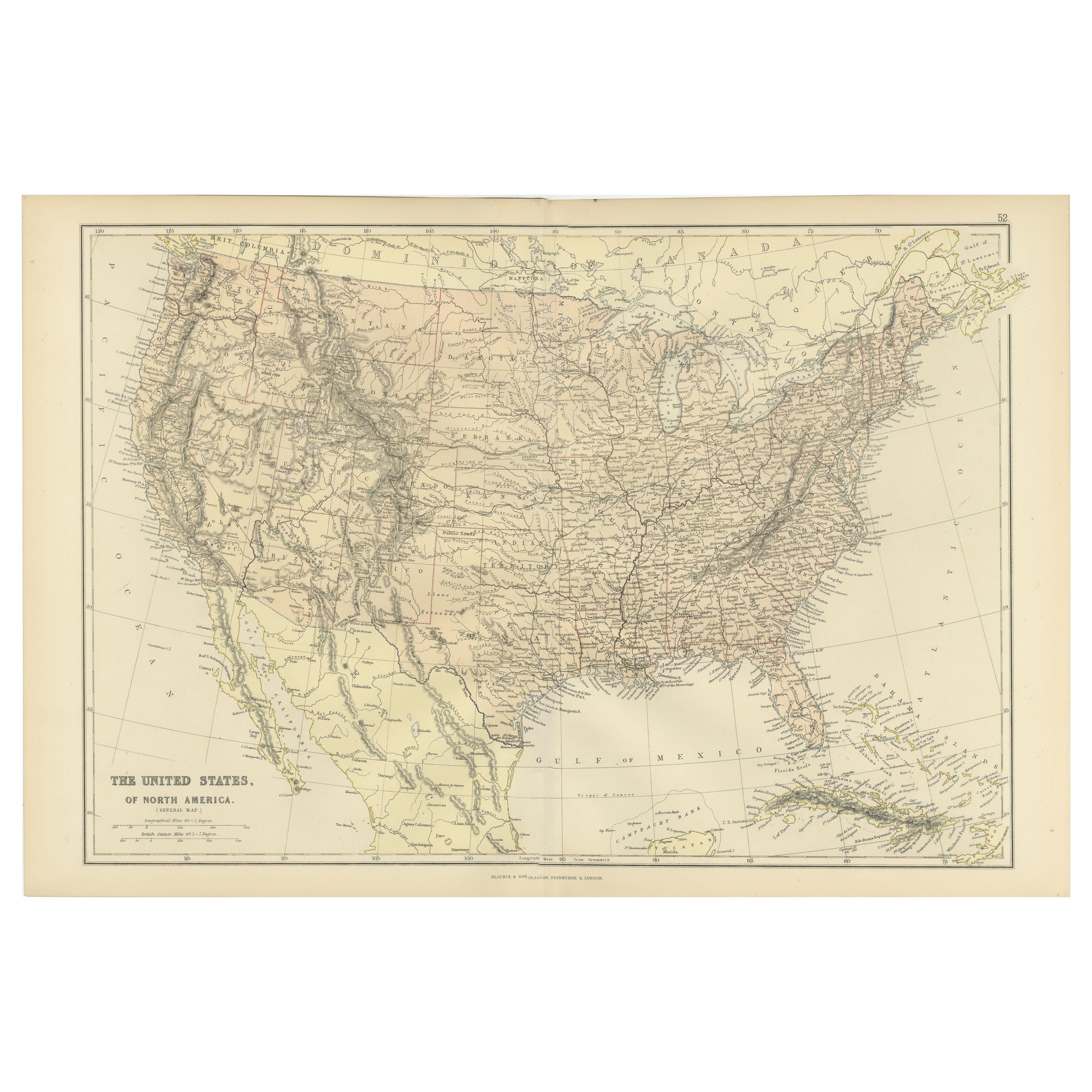
- Antique Map of the United States of North America, c.1882Located in Langweer, NLAntique map titled 'United States of North America'. Old map of the United States of North America. This map originates from 'The Royal Atlas of Modern Geography, Exhibiting, in a Se...Category
Antique 1880s Maps
MaterialsPaper
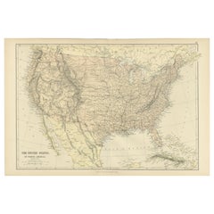
- Antique Map of The United States of North America, 1882Located in Langweer, NLThis is a historical map titled "The United States of North America, Central Part" from the 1882 Blackie Atlas. It depicts the continental United States with a high level of detail, ...Category
Antique 1880s Maps
MaterialsPaper
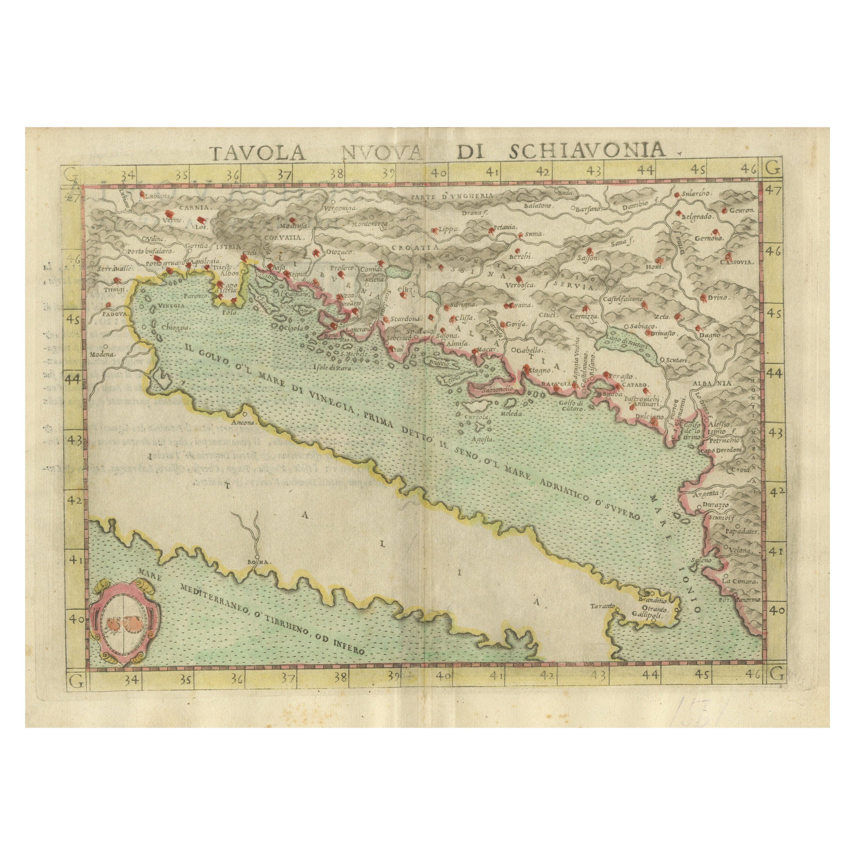
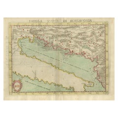
- Antique Map of the Balkans with Coat of ArmsLocated in Langweer, NLAntique map titled 'Tavola Nuova di Schiavonia'. Ruscelli's map of the Balkans, with a coat of arms. The mountains are represented, river systems are shown in detail, and cities, towns and ports denoted throughout this 16th century map. A number of islands in the Adriatic Sea are also shown. This map originates from 'Espositione & introduttioni universali di Gir. Ruscelli sopra tutta la Geografia di Tolomeo (..)' published by Girolamo Ruscelli, 1561. Girolamo Ruscelli (1500-1566) was a cartographer, humanist, and scholar from Tuscany. Ruscelli was a prominent writer and editor in his time, writing about a wide variety of topics including the works of Giovanni Boccaccio and Francesco Petrarch, Italian language, Italian poetry, medicine, alchemy, and militia. One of his most notable works was a translation of Ptolemy...Category
Antique 16th Century Maps
MaterialsPaper
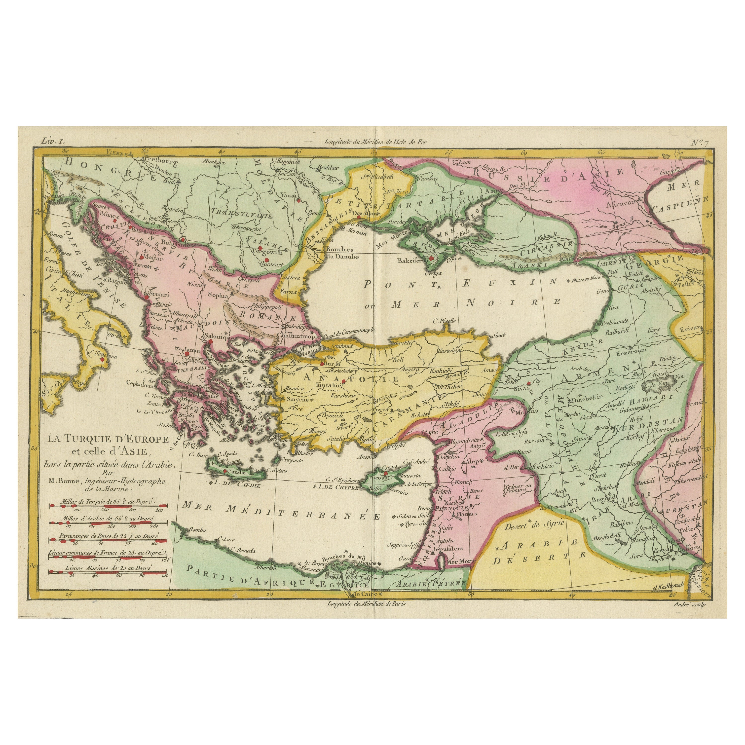
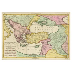
- Antique Map of the Eastern Mediterranean and the BalkansLocated in Langweer, NLAntique map titled 'La Turquie d'Europe et celle d'Asie'. Attractive double page map of the Eastern Mediterranean and the Balkans by R. Bonne. Originates from 'Atlas de Toutes les Pa...Category
Antique Late 18th Century Maps
MaterialsPaper

You May Also Like
- Framed 1820s Hand Colored Map of the United StatesLocated in Stamford, CTFramed 1820s hand colored map photos of North America and South America. As found framed in giltwood frame.Category
Antique 1820s American Spanish Colonial Maps
MaterialsGiltwood, Paper, Glass
- Framed 1839 Hand Colored Map of the United StatesLocated in Stamford, CTFramed hand colored map of the United States of America from 1839. Newly framed in a giltwood frame.Category
Antique 1830s American American Classical Maps
MaterialsGiltwood, Paper, Glass
- 1859 "Map of the United States of America..." by J. H. ColtonBy J.H. ColtonLocated in Colorado Springs, COPresented is an 1859 “Map of the United States of America, the British Provinces, Mexico, the West Indies and Central America with Part of...Category
Antique 1850s American Maps
MaterialsPaper
- 1863 "Lloyd's New Map of the United States, the Canadas, and New Brunswick"Located in Colorado Springs, COPresented is “Lloyd's New Map of the United States, the Canadas and New Brunswick, From the latest Surveys, Showing Every Railroad & Station Finished to June 1863, and the Atlantic and Gulf Coasts.” A large, Civil War-era hanging map of the United States and adjacent territories, this map covers the area from the Atlantic Ocean and extends as far west as the 103 meridian, to “Dacotah,” Nebraska, Kansas, "Indian Territory," and Texas. The southern continuation of Florida is shown in an inset map along the right margin. This map was published by J. T. Lloyd, in New York, in 1863. According to the publisher’s marking at lower right, this map was originally issued in two states: "in Sheets, Colored" for 50 cents, and "Varnished nicely, with Rollers" for $1. Throughout the map, the counties are colored and the towns and cities well labeled. A reference key in the bottom margin provides symbols for railroads, turnpikes and wagon roads, state capitals, cities and towns, and village post offices. As emphasized in the map’s title, this map is especially notable for the countless railway lines and stations depicted, with distances noted between points, listing “every railroad and finished station to June 1863.” Additionally, two shipping agents and their routes are drawn out of New York City. The map includes details of the steamship routes into New York and Philadelphia from Liverpool and on to California and Oregon via an overland Nicaraguan trek, presumably to assist gold rush emigrants. This expansive and impressive map depicts the eastern half of the United States in the third year of the Civil War. In order not to recognize the legitimacy of the Confederate States of America, each state is shown in the same manner as the Union states. The only indication that the American Civil War was in progress when this map was published is a printed notice that Gideon Wells, Secretary of the Navy, wishes to acquire a quote on 100 copies of Lloyd’s Mississippi River map...Category
Antique 1860s American Maps
MaterialsLinen, Wood, Paper
- 18th Century Map of the Southern Balkans by Giovanni Maria CassiniBy Giovanni Maria CassiniLocated in Hamilton, Ontario18th century map by Italian engraver Giovanni Maria Cassini (Italy 1745-1824). Map of the Southern Balkans: Rome. Hand colored and copper engraved print done in the year 1788. It in...Category
Antique 18th Century Italian Maps
MaterialsPaper
- 1873 "Map of the States of California and Nevada" by Chas. Drayton GibbesLocated in Colorado Springs, COPresented is Warren Holt and Charles Drayton Gibbes' 1873 “Map of California and Nevada.” This map is considered to be one of the finest large-scale ...Category
Antique 1870s American Maps
MaterialsPaper


Recently Viewed
View AllMore Ways To Browse
Engraved Cross
Collectors And Curiosities
Minature Map
Anguilla Map
James Calvert Smith
Winkler Prins
A Plan City And Castle Of Batavia
Antique Maine Maps
Shetland Map
Antique Map Iceland
Antique Map Of Iceland
Antique Map Of Maine
Tartar Map
Victor Levasseur On Sale
Antique Curiosities North Carolina
Bolivia Antique Map
Irish Canterbury Furniture
Irish Canterbury