Items Similar to West Coast of Africa, Guinea & Sierra Leone: An 18th Century Map by Bellin

Want more images or videos?
Request additional images or videos from the seller
1 of 7
West Coast of Africa, Guinea & Sierra Leone: An 18th Century Map by Bellin
About the Item
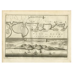
Jacques Bellin's copper-plate map entitled "Partie de la Coste de Guinee Dupuis la Riviere de Sierra Leona Jusquau Cap das Palmas", depicting the coast of Guinea and Sierra Leone in West Africa, published in Paris in Antoine-Francois Prevost's "Histoire Générale des Voyages, ou nouvelle collection de toutes les relations de voyages par mer et par terre, qui ont été publiées jusqu'à present dans les différentes langues de toutes les nations connues".
Prevost's "L'Histoire Generale des Voyages" was an expansive work that mapped China, the East Indies, Asia, the Americas, early voyages to Australia, New Guinea, the Palau Islands, Africa, and voyages in the Pacific including those of Magellan, Schouten, and Le Maire, Drake, Sarmiento, Cavendish, Spilbergen, Narborough, Rogers, Cowley, Frazier, and Anson. The work included accounts of the Dutch and French voyages to the East Indies, voyages to China, and the British East India Company's voyages to India and Ceylon. The publication was published before the three voyages of discovery by Captain James Cook later in the 18th century.
The map is printed on laid, chain-linked, watermarked paper. There are wide margins all around and a central vertical fold, as issued. There is mild spotting in the upper margin and to a lesser extent in the right margin, but the map is otherwise in excellent condition.
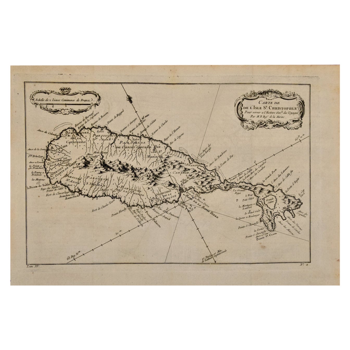
Two other Bellin maps are available on 1stDibs, including an unframed map of the island of St. Christophe, now known as St. Kitts, "Carte De De l'Isle St. Christophe", Reference #: LU117328585712 and a map of St. Lucie framed in lucite, Reference: LU117324370471. These maps would make a striking display grouping. A discount is available for the purchase of two or more maps.
The map was prepared by Jacques Nicolas Bellin (1703–1772), who was one of the most important cartographers of the 18th century. He served for a number of years as map and chart maker, as well hydrographer to the King of France.
- Creator:Jacques-Nicolas Bellin (Artist)
- Dimensions:Height: 10 in (25.4 cm)Width: 14.25 in (36.2 cm)Depth: 0.07 in (1.78 mm)
- Materials and Techniques:Paper,Engraved
- Place of Origin:
- Period:
- Date of Manufacture:1746
- Condition:Wear consistent with age and use.
- Seller Location:Alamo, CA
- Reference Number:
About the Seller
5.0
Vetted Seller
These experienced sellers undergo a comprehensive evaluation by our team of in-house experts.
1stDibs seller since 2020
12 sales on 1stDibs
- ShippingRetrieving quote...Ships From: Alamo, CA
- Return PolicyA return for this item may be initiated within 7 days of delivery.
More From This SellerView All
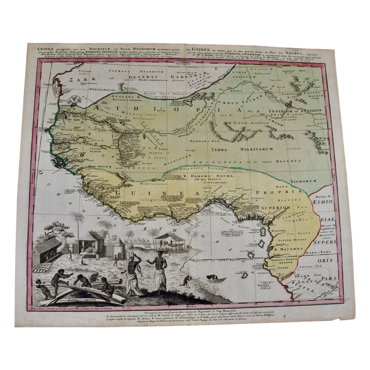
- West Africa Entitled "Guinea Propria": An 18th Century Hand Colored Homann MapBy Johann Baptist HomannLocated in Alamo, CAThis is a scarce richly hand colored copper plate engraved map of Africa entitled "Guinea Propria, nec non Nigritiae vel Terrae Nigrorum Maxima Pars" by Johann Baptist Homann (1664-1...Category
Antique Mid-18th Century German Maps
MaterialsPaper
- St. Christophe 'St. Kitts' Island: An 18th Century Hand-colored Map by BellinBy Jacques-Nicolas BellinLocated in Alamo, CAJacques Bellin's copper-plate map of the Caribbean island of Saint Kitts entitled "Carte De De l'Isle St. Christophe Pour servir á l'Histoire Genle. des V...Category
Antique Mid-18th Century French Maps
MaterialsPaper
- Captain Cook's Exploration of Tahiti 18th C. Hand-Colored Map by BellinBy Jacques-Nicolas BellinLocated in Alamo, CAThis beautiful 18th century hand-colored copper plate engraved map is entitled "Carte de l'Isle de Taiti, par le Lieutenant J. Cook" was created by Jacques Nicolas Bellin and publish...Category
Antique Mid-18th Century French Maps
MaterialsPaper
- 17th Century Hand-Colored Map of West Africa by Mercator/HondiusLocated in Alamo, CAA 17th century hand-colored map entitled "Guineae Nova Descriptio" by Gerard Mercator and Jodocus Hondius, published in their 'Atlas Minor' in Amsterdam in 1635. It is focused on the...Category
Antique Mid-17th Century Dutch Maps
MaterialsPaper
- Germany West of the Rhine: A Hand-colored 18th Century Map by de WitBy Frederick de WitLocated in Alamo, CAThis original 18th century hand-colored map of the county of Moers, Germany entitled "Illustrissimo Celsissmo Principi GUILIELMO HENRICO D.G. Arausionum Principi Domino suo Clementis...Category
Antique Early 18th Century Dutch Maps
MaterialsPaper
- City View of Nuremberg, Germany: An 18th Century Hand-Colored Map by M. SeutterBy Matthew SeutterLocated in Alamo, CAAn 18th century hand-colored city view of Nuremburg, Germany entitled "Geometrischer Grundris der des Heiligen Römischen Reichs Freyen Stadt Nürnberg" by Matthaus Seutter from his "A...Category
Antique Mid-18th Century German Maps
MaterialsPaper


You May Also Like
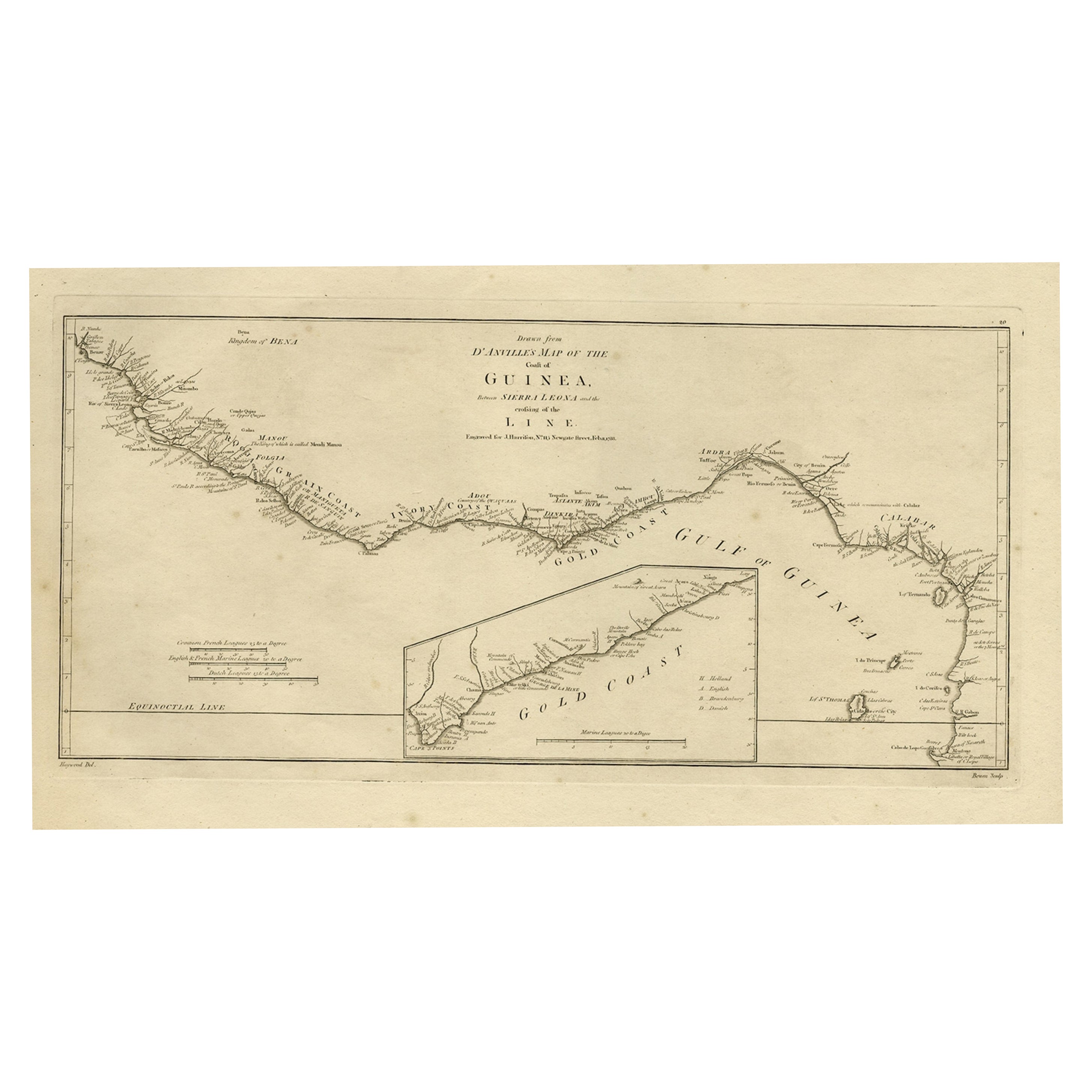
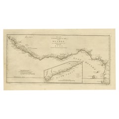
- Map of the African Coast, Gulf of Guinea, from Sierra Leone to Gabon, 1788Located in Langweer, NLAntique map titled 'Drawn from d'Anvilles Map of the Coast of Guinea, Between Sierra Leone and the crossing of the Line.' Map of the African coast, Gulf of Guinea, from Sierra Le...Category
Antique 1780s Maps
MaterialsPaper
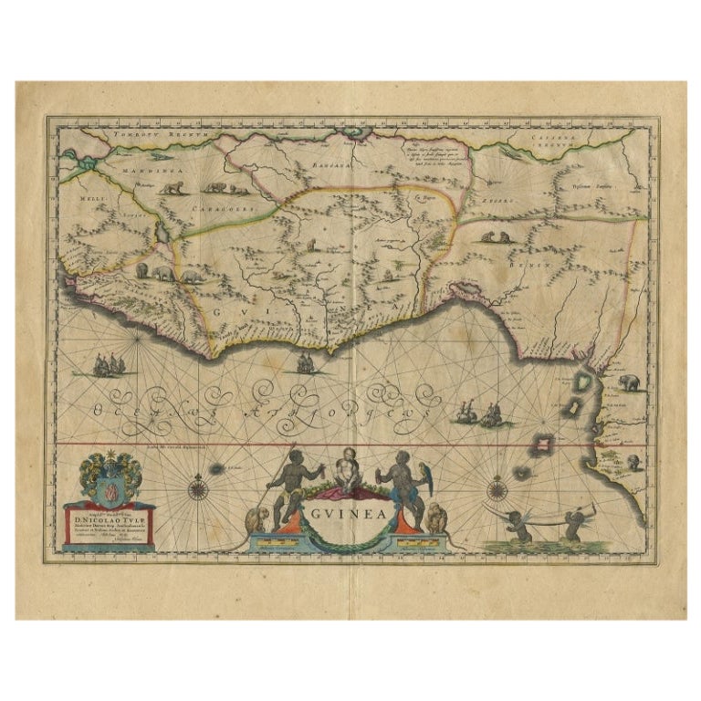
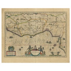
- Antique Map of Guinea in West Africa by Blaeu, c.1638Located in Langweer, NLAntique map titled 'Guinea'. Decorative map of West Africa, including numerous animals in the interior, sailing ships and several elegant cartouches. Both the map and the sea are s...Category
Antique 17th Century Maps
MaterialsPaper
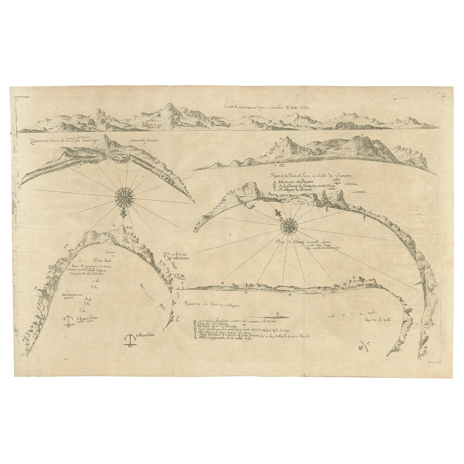
- Rare Map of Six Coast Views and Anchorages of Sierra Leone and Indonesia, 1660Located in Langweer, NLThis rare antique map includes six coastal elevation views of anchorages and bays favored by Dutch and French vessels on their way to Asia. Two views of the coast of Sierra Leone, Africa "Tagrin" opposite Freetown. A view of the coast of Aceh on the northern coast of Sumatra and a further unidentified anchorage "Baye de l'Encau". A view of the African coast including the Bay of Saldagne and Table Bay...Category
Antique 17th Century Maps
MaterialsPaper
- Antique Map and View of the Bay of Sierra Leone in Africa, C.1750Located in Langweer, NLAntique print titled 'Baye de Sierra Leona (..) - Baai van Sierra Leona (..)'. Map and view of the bay of Sierra Leone. This print originates from 'Historische beschryving der Reizen...Category
Antique 18th Century Prints
MaterialsPaper
- Antique Map of Celebes 'Sulawesi, Indonesia' by Bellin, ciarca 1755By Jacques-Nicolas BellinLocated in Langweer, NLAntique map titled 'Carte de l'Isle Celebes ou Macassar'. Map of Celebes (Sulawesi, Indonesia), showing Makassar, which was the most important trading city of eastern Indonesia in th...Category
Antique Mid-18th Century European Maps
MaterialsPaper
- Antique Map of Tartary and Northeast Asia by Bellin, circa 1750By Jacques-Nicolas BellinLocated in Langweer, NLAntique map titled 'Carte de la Tartarie Occidentale'. Map of Tartary and northeast Asia, from Lake Baykal, Partie du Siberia in the north, Pays des Kalkas at the center, as well as ...Category
Antique Mid-18th Century European Maps
MaterialsPaper


Recently Viewed
View AllMore Ways To Browse
New West Furniture
East West Furniture
Pacific Furniture Mid Century
West African Furniture
French Copper 18th
18th Century French Copper
African American Mid Century
Africa Map
West Indies Furniture
Furniture West Indies
18th Century Engraved Frame
Map Australia
Maps Of Australia
West Indies Antique Furniture
18th Century African
Antique African American
African American Antique
African Plate