Items Similar to Canada Dominion Map 1903 - A Detailed View of Eastern Canada and Newfoundland

Want more images or videos?
Request additional images or videos from the seller
1 of 10
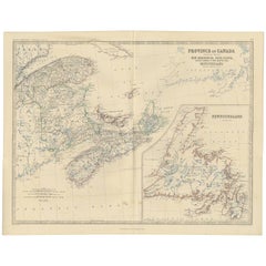
Canada Dominion Map 1903 - A Detailed View of Eastern Canada and Newfoundland
$406.51
£300.94
€340
CA$562.51
A$620.15
CHF 324.44
MX$7,608.11
NOK 4,084.10
SEK 3,819.28
DKK 2,589.91
About the Item
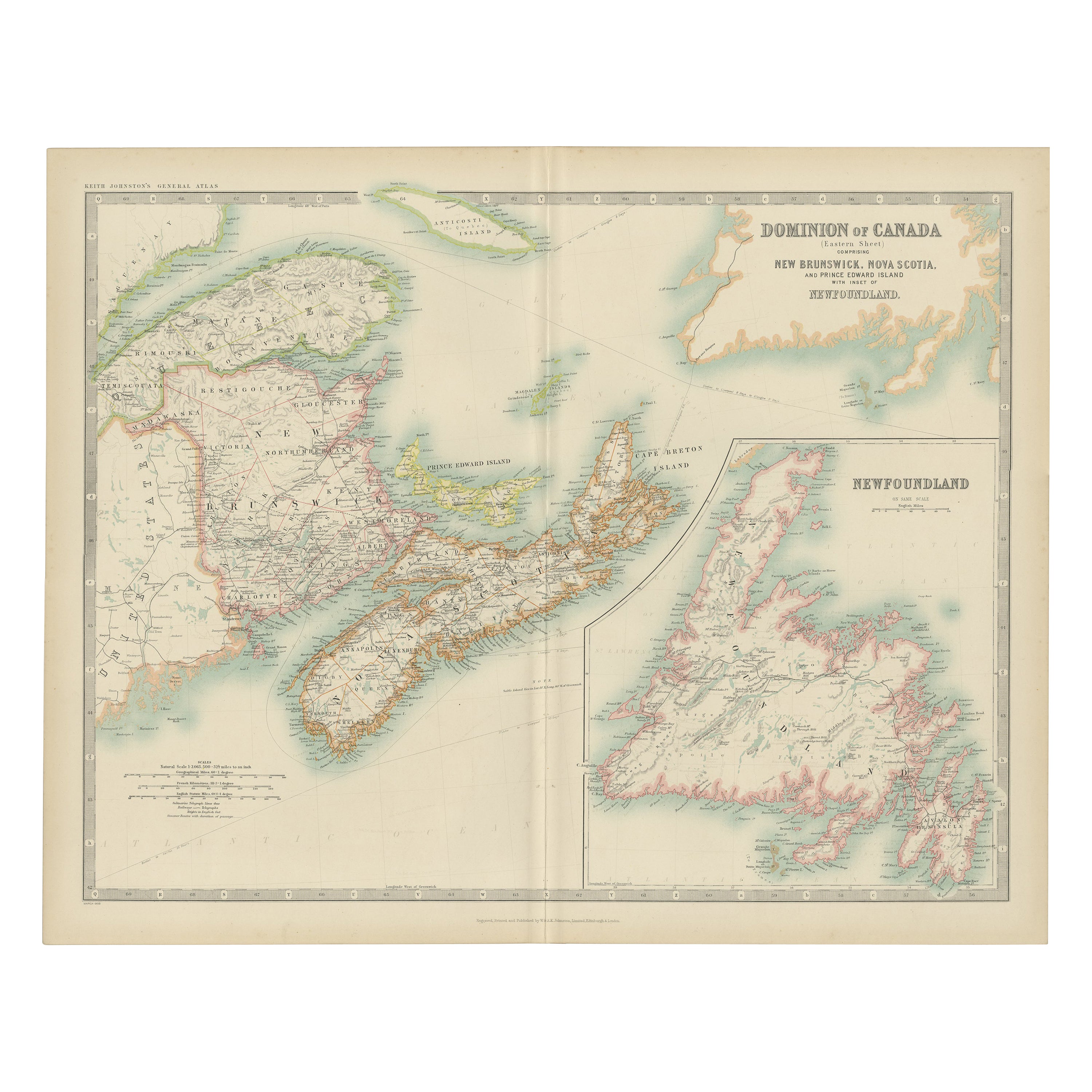
North America, 1903 - A Colorful Historical Map with Detailed Borders
This attractive map of North America was engraved, printed, and published by W. & A.K. Johnston in 1903. A wonderful example of early 20th-century cartography, it captures the complex geography and political divisions of Canada, the United States, Mexico, Central America, the Caribbean, and the Arctic regions in a detailed and colorful presentation.
The map is filled with fascinating details, including major cities, rivers, mountain ranges, and railway lines that crisscrossed the continent at the time. Political boundaries are clearly marked in different colors, distinguishing the various countries and regions. The northern reaches of Canada and Alaska are depicted with impressive accuracy for the era, as are the Caribbean islands and Central American states.
The bright yet subtle color palette—red for borders, blue for water, and a gentle green for mountain shading—makes this map visually appealing and easy to read. The map also includes detailed insets and a clear legend showing the scale and distances, making it a valuable reference for historians and collectors interested in the evolution of North America’s borders.
Condition report:
This map is in very good condition, with some minor foxing and small creases typical of antique maps. The paper is strong, and the colors remain clear and vibrant.
Framing tips:
This historical map would look splendid in a black or dark wood frame, perhaps with a white or cream mat to highlight the soft colors. A museum-quality glass can protect the map while preserving the crisp details and ensuring a long-lasting display in an office, library, or living room.
- Dimensions:Height: 14.49 in (36.8 cm)Width: 18.51 in (47 cm)Depth: 0.01 in (0.2 mm)
- Materials and Techniques:
- Period:
- Date of Manufacture:1903
- Condition:This map is in very good condition, with some minor foxing and small creases typical of antique maps. The paper is strong, and the colors remain clear and vibrant.
- Seller Location:Langweer, NL
- Reference Number:Seller: BG-13577-411stDibs: LU3054345291452
About the Seller
5.0
Recognized Seller
These prestigious sellers are industry leaders and represent the highest echelon for item quality and design.
Platinum Seller
Premium sellers with a 4.7+ rating and 24-hour response times
Established in 2009
1stDibs seller since 2017
2,613 sales on 1stDibs
Typical response time: <1 hour
- ShippingRetrieving quote...Shipping from: Langweer, Netherlands
- Return Policy
Authenticity Guarantee
In the unlikely event there’s an issue with an item’s authenticity, contact us within 1 year for a full refund. DetailsMoney-Back Guarantee
If your item is not as described, is damaged in transit, or does not arrive, contact us within 7 days for a full refund. Details24-Hour Cancellation
You have a 24-hour grace period in which to reconsider your purchase, with no questions asked.Vetted Professional Sellers
Our world-class sellers must adhere to strict standards for service and quality, maintaining the integrity of our listings.Price-Match Guarantee
If you find that a seller listed the same item for a lower price elsewhere, we’ll match it.Trusted Global Delivery
Our best-in-class carrier network provides specialized shipping options worldwide, including custom delivery.More From This Seller
View AllAntique Map of Canada by Johnston '1909'
Located in Langweer, NL
Antique map titled 'Dominion of Canada'. Original antique map of Canada. With inset map of Newfoundland. This map originates from the ‘Royal Atla...
Category
Early 20th Century Maps
Materials
Paper
$239 Sale Price
20% Off
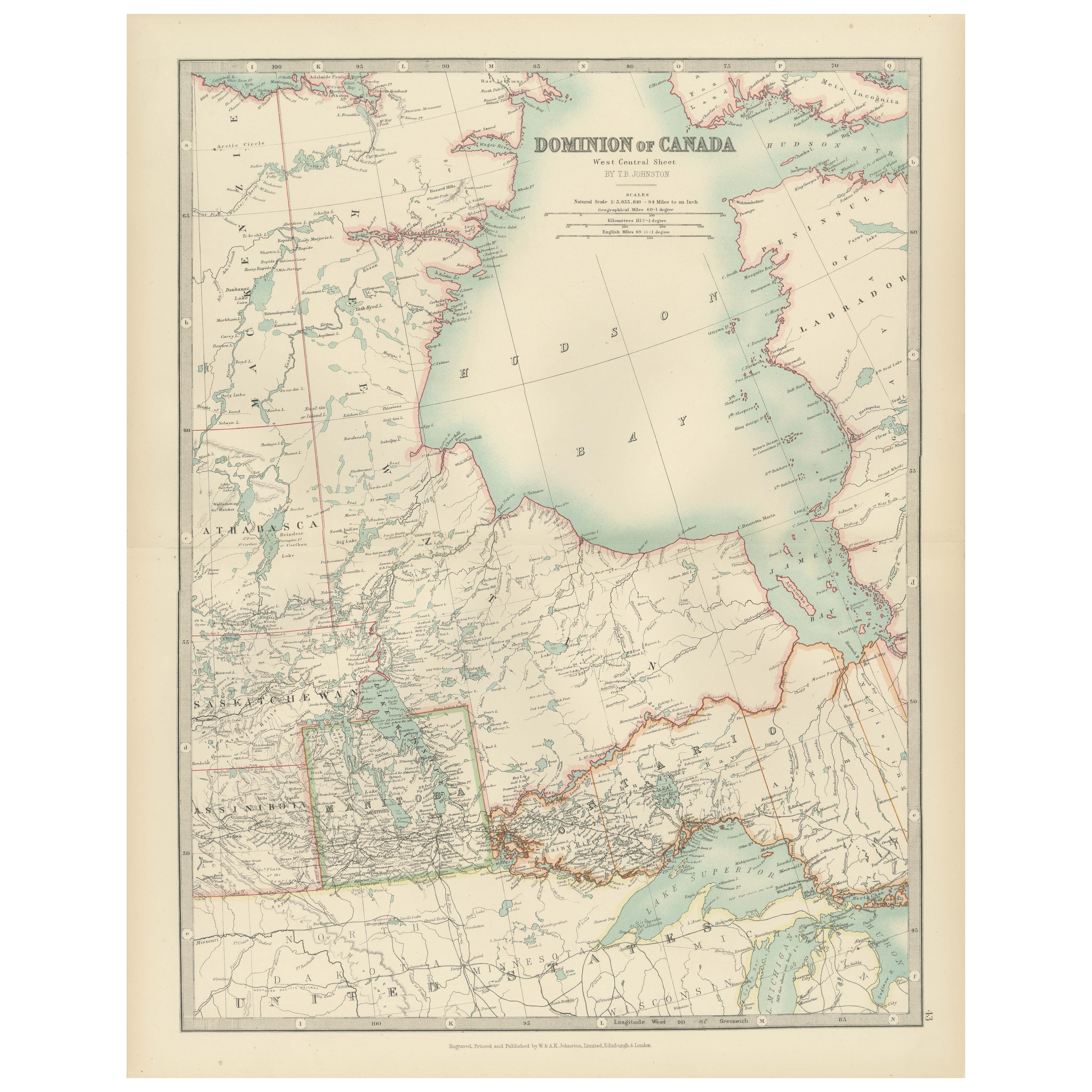
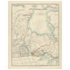
Canada Map 1903 - Dominion of Canada, West Central Sheet
Located in Langweer, NL
Title: Canada Map 1903 - Dominion of Canada, West Central Sheet
Description:
This fascinating 1903 map of the Dominion of Canada’s West Central regions by T.R. Johnston offers a viv...
Category
Early 20th Century Maps
Materials
Paper
Antique Map of Eastern Canada with an inset Map of Newfoundland, 1882
Located in Langweer, NL
Antique map titled 'Dominion of Canada'. Old map of Eastern Canada with an inset map of Newfoundland. This map originates from 'The Royal Atlas of Modern Geography, Exhibiting, in a ...
Category
Antique 19th Century Maps
Materials
Paper

$267 Sale Price
20% Off
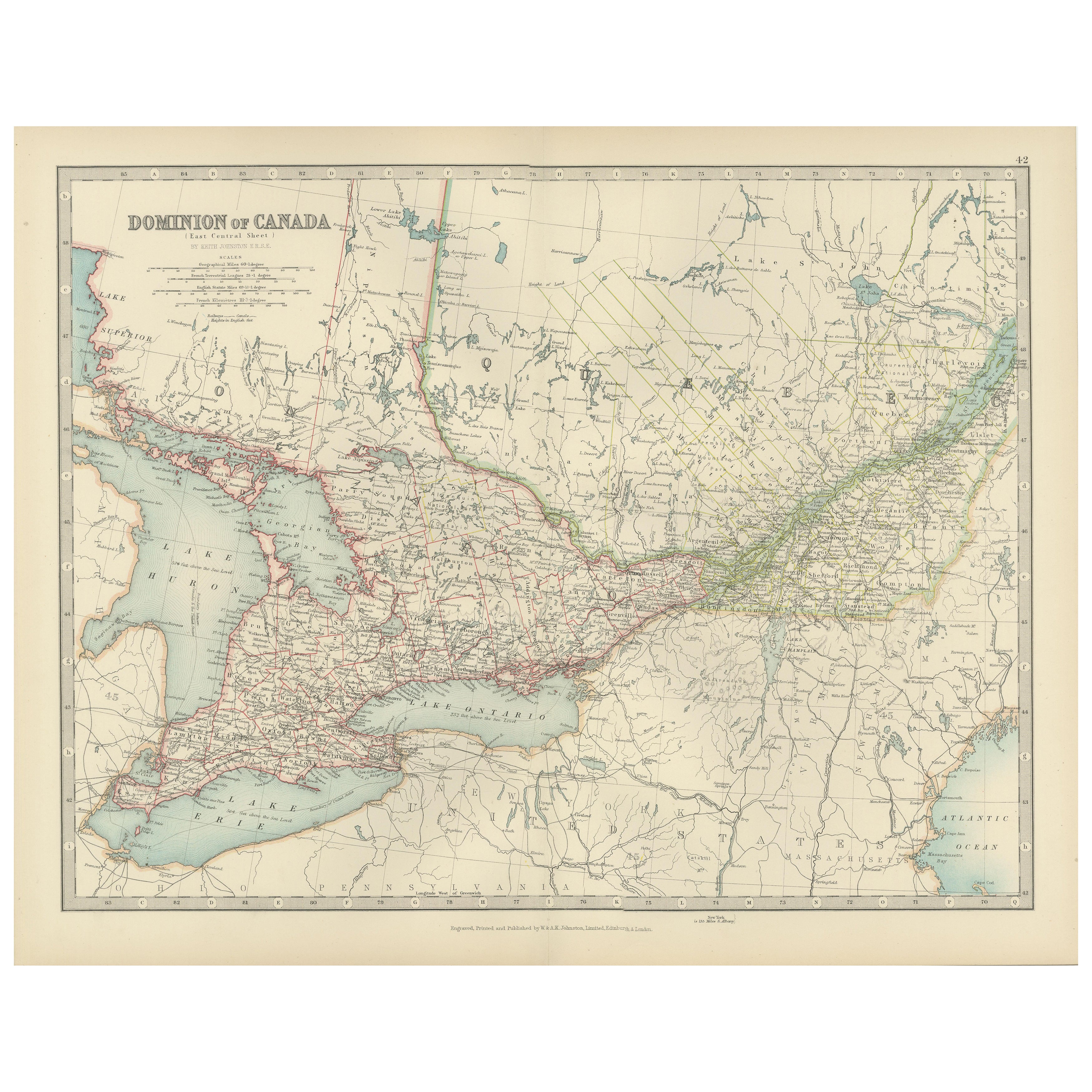
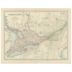
Canada Map 1903 - East Central Dominion - Ontario, Quebec & More
Located in Langweer, NL
Canada Map 1903 - East Central Dominion - Ontario, Quebec & More
This captivating antique map, titled "Dominion of Canada (East Central Sheet)" and published in 1903 by Keith Johnst...
Category
Early 20th Century Maps
Materials
Paper
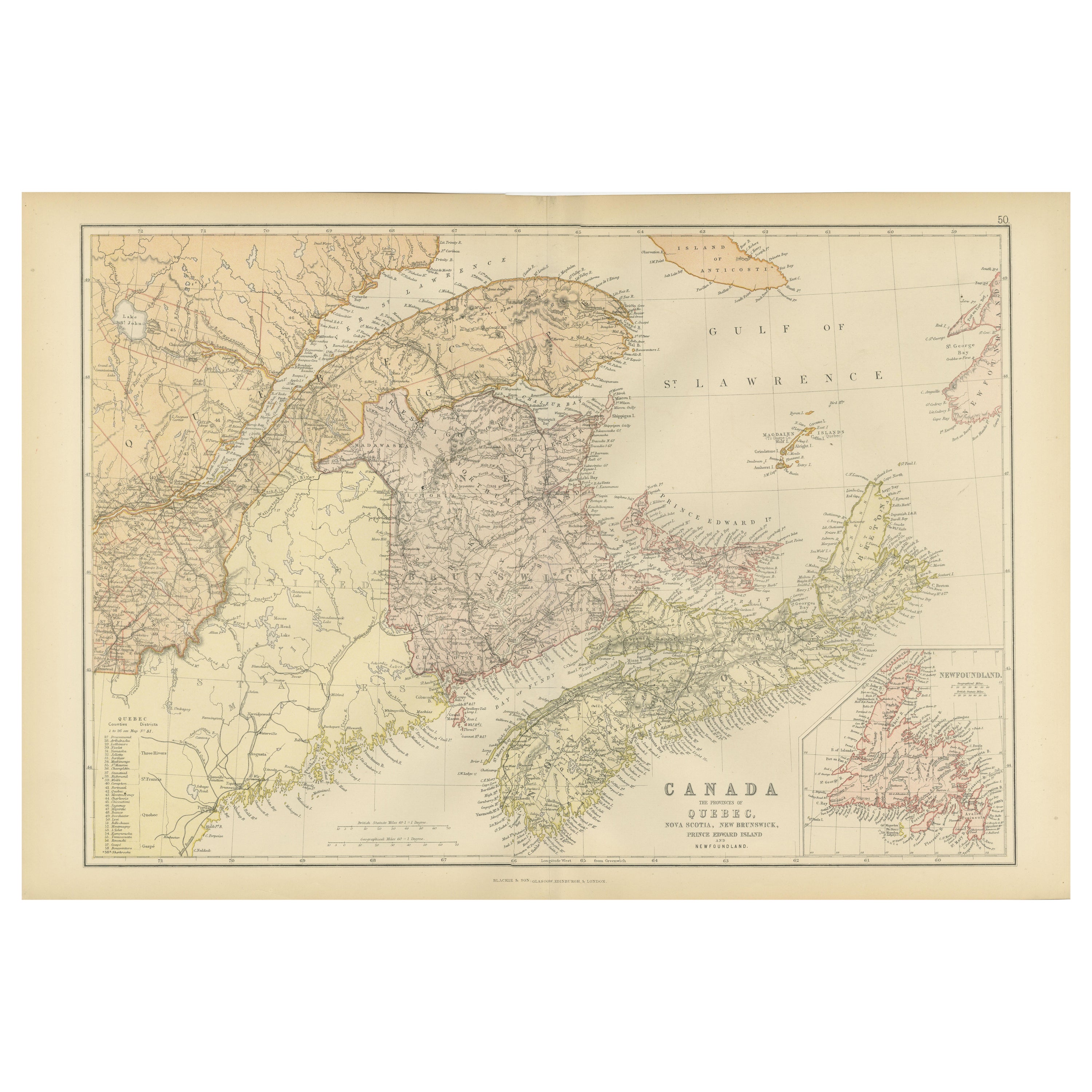
Decorative Antique Map of Eastern Canada, Published in 1882
Located in Langweer, NL
This is a historical map from the 1882 Blackie Atlas, focused on eastern Canada and the maritime provinces. The map is titled "Canada. No. 2. Provinces of Nova Scotia, New Brunswick,...
Category
Antique 1880s Maps
Materials
Paper

Antique Map of the Province of Canada 'East' by A.K. Johnston, 1865
Located in Langweer, NL
Antique map titled 'Province of Canada (Eastern Sheet)'. Depicting New Brunswick, Newfoundland, Cape Breton Island, Prince Edward Island, Nova Scotia and m...
Category
Antique Mid-19th Century Maps
Materials
Paper
$248 Sale Price
20% Off
You May Also Like
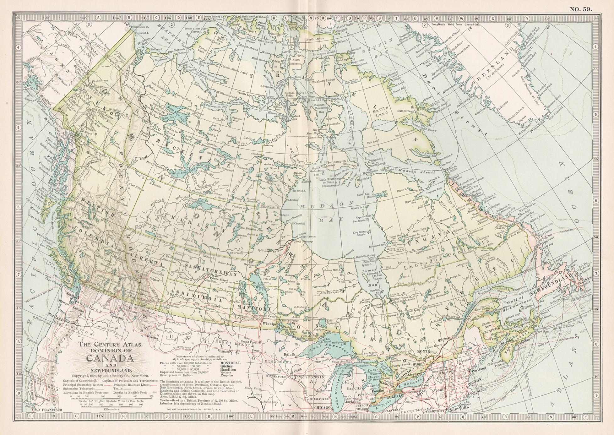
Canada and Newfoundland. Century Atlas antique vintage map
Located in Melbourne, Victoria
'The Century Atlas. Dominion of Canada and Newfoundland.'
Original antique map, 1903.
Central fold as issued. Map name and number printed on the reverse corners.
Sheet 29.5cm by 40...
Category
Early 20th Century Victorian More Prints
Materials
Lithograph

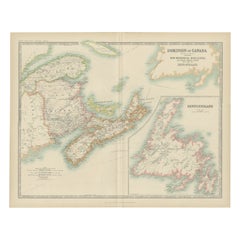
New Brunswick, Nova Scotia and Prince Edward Island, Canada. Century Atlas map
Located in Melbourne, Victoria
'The Century Atlas. New Brunswick, Nova Scotia and Prince Edward Island, Canada.'
Original antique map, 1903.
Inset map of Newfoundland.
Central...
Category
Early 20th Century Victorian More Prints
Materials
Lithograph
Original Antique Map of New Brunswick and Nova Scotia, 1889
Located in St Annes, Lancashire
Great map of New Brunswick and Nova Scotia
Drawn and Engraved by W. & A.K. Johnston
Published By A & C Black, Edinburgh.
Original colour
Unfr...
Category
Antique 1880s Scottish Victorian Maps
Materials
Paper

Quebec. Canada. Century Atlas antique vintage map
Located in Melbourne, Victoria
'The Century Atlas. Quebec'
Original antique map, 1903.
Inset maps 'Sketch Map of Quebec', Quebec and Vicinity; and 'Montreal and Vicinity'.
Central fo...
Category
Early 20th Century Victorian More Prints
Materials
Lithograph

Manitoba, British Columbia and NW Territories, Canada. Century Atlas antique map
Located in Melbourne, Victoria
'The Century Atlas. Manitoba, British Columbia and the Northwest Territories, Canada, North America.'
Original antique map, 1903.
Central fold as issued. Map name and number printe...
Category
Early 20th Century Victorian More Prints
Materials
Lithograph

Large Original Vintage Map of North America, circa 1920
Located in St Annes, Lancashire
Great map of North America
Original color. Good condition
Published by Alexander Gross
Unframed.
Category
Vintage 1920s English Edwardian Maps
Materials
Paper

More Ways To Browse
Antique Furniture Newfoundland
Antique Newfoundland Canada
Painted Bar Stools
3x5 Rugs
Tufted Bar
Green Oushak
Pelle Pelle Leather
Antique Marble Top Hall Table
Bent Plywood
Antique Column Base
Bureau Desk
Low Black Coffee Table
Porcelain Modern Hand Painted
Dining Tables With Brass Inlay
Louis Marble Top Side Table
Palace Size Carpet
Armchair In France
Blue Kilim Vintage