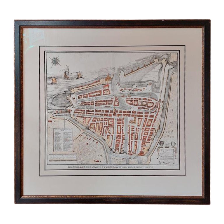
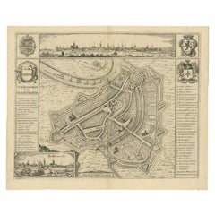
Items Similar to Framed 1731 Color Engraving, Map of Rotterdam by Matthaus Seutter, "Roterodami"
Want more images or videos?
Request additional images or videos from the seller
1 of 12
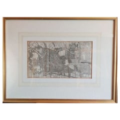
Framed 1731 Color Engraving, Map of Rotterdam by Matthaus Seutter, "Roterodami"
$1,400
£1,061.62
€1,228.34
CA$1,978.95
A$2,206.15
CHF 1,150.60
MX$26,677.47
NOK 14,463.58
SEK 13,685.44
DKK 9,168.31
About the Item
"Roterodami". Seutter (1678-1757) was an important German 18th century map maker. Bird's eye view of the city above with full details, neoclassical imagery above right.
Dimensions: sight 20 x 23 1/2" X 1"
matted and framed in burled wood 29 3/4 x 32 3/4"
Condition: Please see all detail photos. There is slight chip upper left corner of the frame which does not detract from the fine presentation.
- Dimensions:Height: 29.75 in (75.57 cm)Width: 32.75 in (83.19 cm)Depth: 1 in (2.54 cm)
- Style:Renaissance (In the Style Of)
- Materials and Techniques:
- Place of Origin:
- Period:
- Date of Manufacture:18th Century
- Condition:Wear consistent with age and use. Minor losses.
- Seller Location:Bridgeport, CT
- Reference Number:Seller: 1218061stDibs: LU1755232934032
About the Seller
5.0
Vetted Professional Seller
Every seller passes strict standards for authenticity and reliability
1stDibs seller since 2015
2,055 sales on 1stDibs
Typical response time: <1 hour
- ShippingRetrieving quote...Shipping from: Bridgeport, CT
- Return Policy
Authenticity Guarantee
In the unlikely event there’s an issue with an item’s authenticity, contact us within 1 year for a full refund. DetailsMoney-Back Guarantee
If your item is not as described, is damaged in transit, or does not arrive, contact us within 7 days for a full refund. Details24-Hour Cancellation
You have a 24-hour grace period in which to reconsider your purchase, with no questions asked.Vetted Professional Sellers
Our world-class sellers must adhere to strict standards for service and quality, maintaining the integrity of our listings.Price-Match Guarantee
If you find that a seller listed the same item for a lower price elsewhere, we’ll match it.Trusted Global Delivery
Our best-in-class carrier network provides specialized shipping options worldwide, including custom delivery.More From This Seller
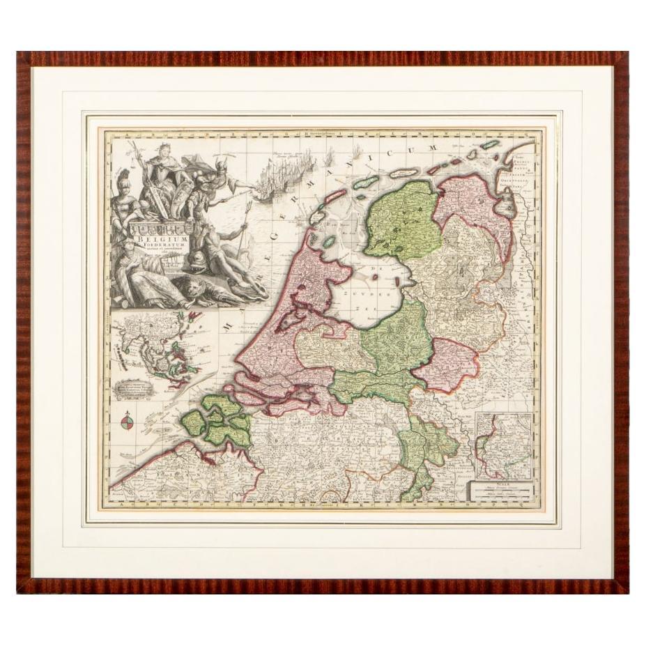
View AllMatthaus Seutter, Framed 1730 Color Engraving Map of "Belgium Fonderatum"
Located in Bridgeport, CT
Label on verso. From Grosser Atlas. The name Belgium comes from the ancient designation "Gallis Belgica". Figural decoration upper left. M. Seutter was a famed German mapmaker in the...
Category
Antique 18th Century European Renaissance Maps
Materials
Brass

Johann Georg Rosenberg (1739-1808) Hand Colored Engravings, Berlin & Amsterdam
Located in Bridgeport, CT
"Grand Place du Chateau et de la Rue Royale prise du Coee des Arcades". A view of the Berlin city square with the old neoclassical palace decorated with sculptures along the roof and...
Category
Antique 18th Century European Renaissance Prints
Materials
Gesso, Glass, Giltwood, Paper

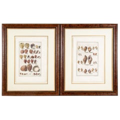
Niccolo Gualtieri, Florentine Conchologist/Artist, Two Framed 1742 Engravings
By Niccolo Gualtier
Located in Bridgeport, CT
Niccolo Gualtieri, Florentine Conchologist/ Artist- Two Framed 1742 Italian Hand Colored Copper Bookplate Engravings- Seashells, From Gualtieri's book "Index Testarum Conchyliorum......
Category
Antique 18th Century Italian Renaissance Prints
Materials
Glass, Wood, Paper
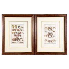
Niccolo Gualtieri, Florentine Conchologist/Artist, Two Framed 1742 Engravings
By Niccolo Gualtier
Located in Bridgeport, CT
Niccolo Gualtieri, Florentine Conchologist/ Artist- Two Framed 1742 Italian Hand Colored Copper Bookplate Engravings- Seashells, From Gualtieri's book "Index Testarum Conchyliorum...Museo Nicolai...
Category
Antique 18th Century Italian Rococo Prints
Materials
Wood, Paper
Giovanni Battista Piranesi, 18th C. Engraving, View Of The Ruins
By Giovanni Battista Piranesi
Located in Bridgeport, CT
Italian, 1720-1778. With an expected fold down the middle. View of the "Casa Aurea Nerone". From the "Veduta di Roma" series. Artist name in plate lower right.
Dimensions: sight 17...
Category
Antique 18th Century Italian Renaissance Prints
Materials
Glass, Wood, Paper

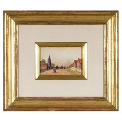
Mrs. Albert Spoor, Watercolor And Gouache On Paper Titled “North Sea Village”
Located in Bridgeport, CT
Watercolor on paper depicting a quiet town scene with two figures walking in the center flanked by a church and structures and sailboats in the distance.
Presented in a lavish gilt f...
Category
20th Century Rustic Paintings
Materials
Glass, Giltwood, Paper
You May Also Like
Antique City Plan of Rotterdam in Frame, ca.1850
Located in Langweer, NL
Antique map titled 'Grondkaart der stad Rotterdam (..)'. Original antique city plan of Rotterdam, the Netherlands. Published circa 1850.
Artists...
Category
Antique 19th Century Prints
Materials
Paper

$616 Sale Price
20% Off
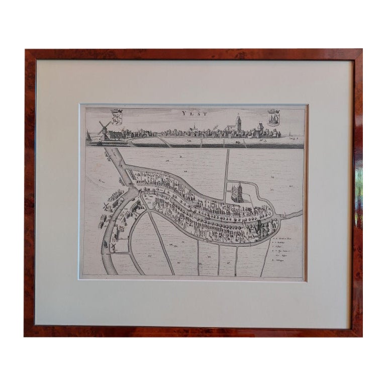
Antique City View and Map of IJlst, City in Friesland, Holland, Framed, 1664
Located in Langweer, NL
Antique map titled 'Ylst'. Old map and city view of the city of IJlst, Friesland. This map originates from 'Beschrijvinge van de Heerlyckheydt van Frieslandt' by B. Schotanus à Sterr...
Category
Antique 17th Century Maps
Materials
Paper

$474 Sale Price
20% Off
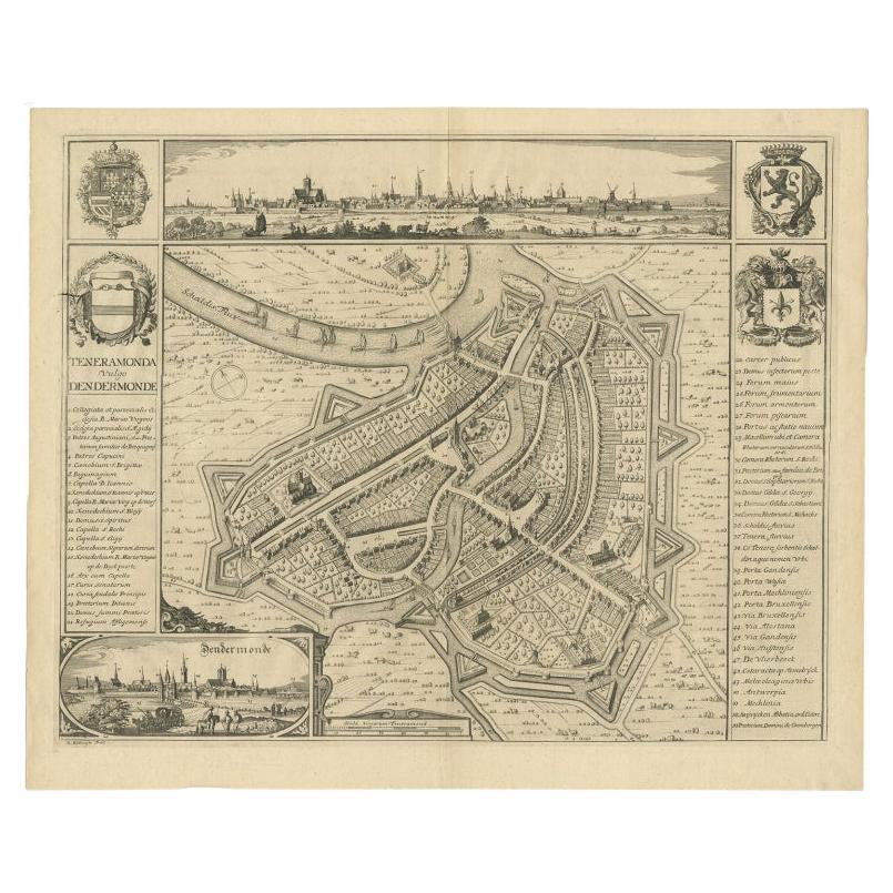
Beautiful Antique Map with Views of Dendermonde, Belgium, 1735
Located in Langweer, NL
Antique map titled 'Teneramonda vulgo Dendermonde'. Beautiful map with views of Dendermonde, Belgium. This map originates from 'Flandria illustrata, sive provinciae ac comitatus huju...
Category
Antique 18th Century Prints
Materials
Paper
$616 Sale Price
20% Off
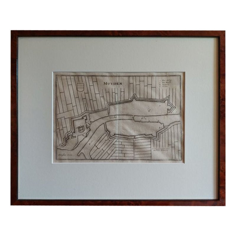
Antique Map of the City of Muiden by Merian, 1659
Located in Langweer, NL
Antique map titled 'Muyden'. Original antique map of the city of Muiden, the Netherlands. This map originates from 'Topographia Germania Inferioris' by C. Merian. Published 1659.
...
Category
Antique 17th Century Maps
Materials
Paper
$147 Sale Price
20% Off
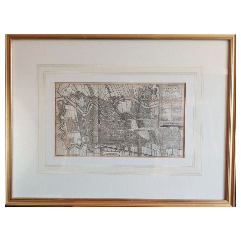
Antique Map of the City of Haarlem by Tirion, 1742
By Isaak Tirion
Located in Langweer, NL
Antique map titled 'Grondtekening van Haarlem (..)'. Original antique map of the city of Haarlem, the Netherlands. Published by I. Tirion, 1742.
Artists and Engravers: Isaak Tirio...
Category
Antique 18th Century Maps
Materials
Paper
$208 Sale Price
20% Off
Original Antique Map of Utrecht in the Netherlands by Blaeu, C.1645
Located in Langweer, NL
Antique map titled 'Ultraiectum Dominium'. Old map of the province of Utrecht, the Netherlands. This map originates from 'Theatrum Orbis Terrarum (..)'.
Artists and Engravers: Wi...
Category
Antique 17th Century Maps
Materials
Paper

$521 Sale Price
20% Off
More Ways To Browse
German Renaissance Wood Furniture
Laos Antique Map
Orinoco Furniture
Johann Baptist Homann On Sale
Rand Mcnally Vintage Maps
Tipu Sultan
Antique Map Bermuda
Antique Map Holder
Lancashire Map
Maltese Falcon
Raised Relief Map
William Dampier
Antique Chesapeake Bay Map
Astrology Map
Mauritius Antique Map
Oman Map
Tanzania Antique Map
Georgetown Map