Items Similar to Hand-Colored Map of Delfland by Hendrik de Leth, 1740 – Delft & The Hague


Want more images or videos?
Request additional images or videos from the seller
1 of 10
Hand-Colored Map of Delfland by Hendrik de Leth, 1740 – Delft & The Hague
$298.90
£221.28
€250
CA$413.61
A$455.99
CHF 238.56
MX$5,594.20
NOK 3,003.01
SEK 2,808.29
DKK 1,904.35
About the Item
Hand-Colored Map of Delfland by Hendrik de Leth, 1740 – Delft & The Hague
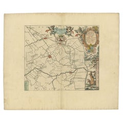
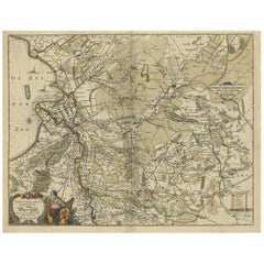
This beautifully preserved antique map titled "Nieuwe Gemeete Kaert van Delfland" was engraved by Hendrik de Leth and published in Amsterdam circa 1740 as part of his *Nieuwe Geographische en Historische Atlas van de Zeven Vereenigde Nederlandsche Provintien*. It offers a richly detailed and historically valuable view of the region known as Delfland, including key cities such as Delft, The Hague ('s Gravenhage), Maassluis, Rijswijk, and Schipluiden.
Drawn and engraved with precision, the map showcases the intricate polder landscape of the western Netherlands, highlighting reclaimed land, dikes, waterways, and windmills. Prominent towns are rendered in red with finely etched city plans and prominent churches, while rural areas are divided into meticulously labeled polders, marked with their respective names. The North Sea lies along the upper edge, and a decorative compass rose sits near the lower right, guiding orientation.
This map is particularly fascinating for its depiction of 18th-century hydraulic engineering and land use in the Dutch Republic. Each polder was a carefully managed parcel of land, often with its own drainage system and governance. The map reflects the Dutch mastery of water management and their cultural emphasis on cooperative land stewardship.
Hendrik de Leth was a prominent Amsterdam publisher and engraver known for his decorative atlases and historical prints. His work is notable for its clarity, ornamentation, and informative quality. The original copper engraving has been delicately hand-colored, likely near the time of publication, enhancing rivers, borders, and built structures while preserving the period aesthetic.
Condition report:
Good condition. Strong impression on laid paper with period hand-coloring. Vertical and horizontal folds as issued. Blank verso. Vibrant colors, minimal age spotting.
Framing suggestion:
Frame in a natural or black-stained wooden frame with a museum-grade off-white mat. Float mounting is ideal to show the full plate including the cartouche and compass rose. UV-protective glass is recommended for preservation.
- Dimensions:Height: 7.09 in (18 cm)Width: 8.86 in (22.5 cm)Depth: 0.01 in (0.2 mm)
- Materials and Techniques:Paper,Engraved
- Period:1740-1749
- Date of Manufacture:1740
- Condition:Good condition. Strong impression on laid paper with period hand-coloring. Vertical and horizontal folds as issued. Blank verso. Vibrant colors, minimal age spotting.
- Seller Location:Langweer, NL
- Reference Number:Seller: BG-028391stDibs: LU3054344977922
About the Seller
5.0
Recognized Seller
These prestigious sellers are industry leaders and represent the highest echelon for item quality and design.
Platinum Seller
Premium sellers with a 4.7+ rating and 24-hour response times
Established in 2009
1stDibs seller since 2017
2,609 sales on 1stDibs
Typical response time: <1 hour
- ShippingRetrieving quote...Shipping from: Langweer, Netherlands
- Return Policy
Authenticity Guarantee
In the unlikely event there’s an issue with an item’s authenticity, contact us within 1 year for a full refund. DetailsMoney-Back Guarantee
If your item is not as described, is damaged in transit, or does not arrive, contact us within 7 days for a full refund. Details24-Hour Cancellation
You have a 24-hour grace period in which to reconsider your purchase, with no questions asked.Vetted Professional Sellers
Our world-class sellers must adhere to strict standards for service and quality, maintaining the integrity of our listings.Price-Match Guarantee
If you find that a seller listed the same item for a lower price elsewhere, we’ll match it.Trusted Global Delivery
Our best-in-class carrier network provides specialized shipping options worldwide, including custom delivery.More From This Seller
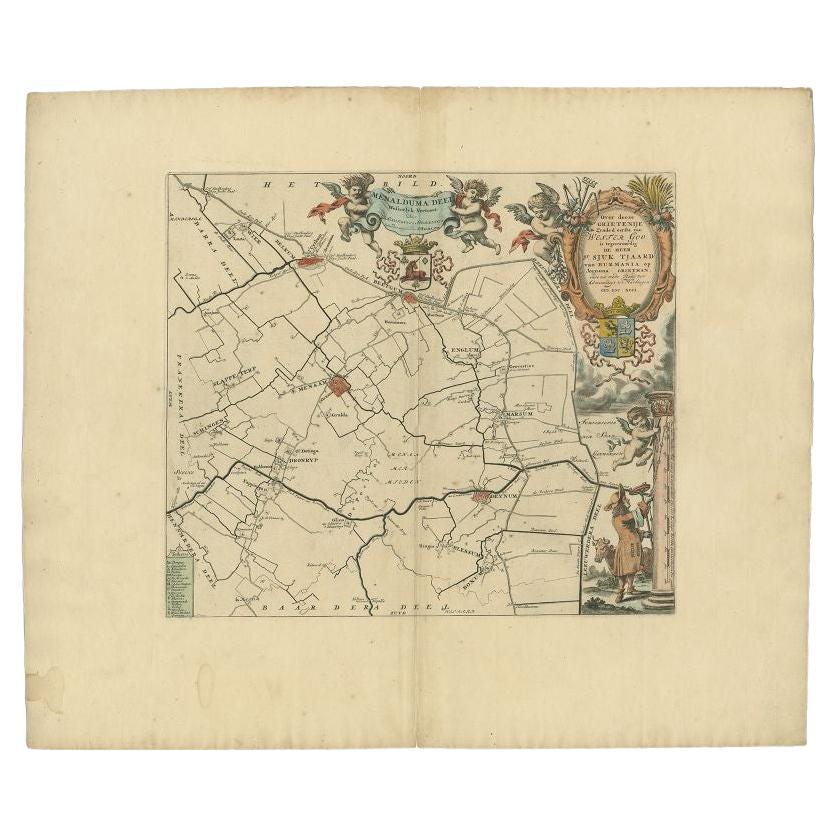
View AllAntique Map of the Menaldumadeel Township 'Friesland' by Halma, 1718
Located in Langweer, NL
Antique map Friesland titled 'Menalduma Deel Wesentlyk vertoont (..)'. Old map of Friesland, the Netherlands. This map depicts the region of Menaldumadeel and includes cities and vil...
Category
Antique 18th Century Maps
Materials
Paper
$315 Sale Price
20% Off
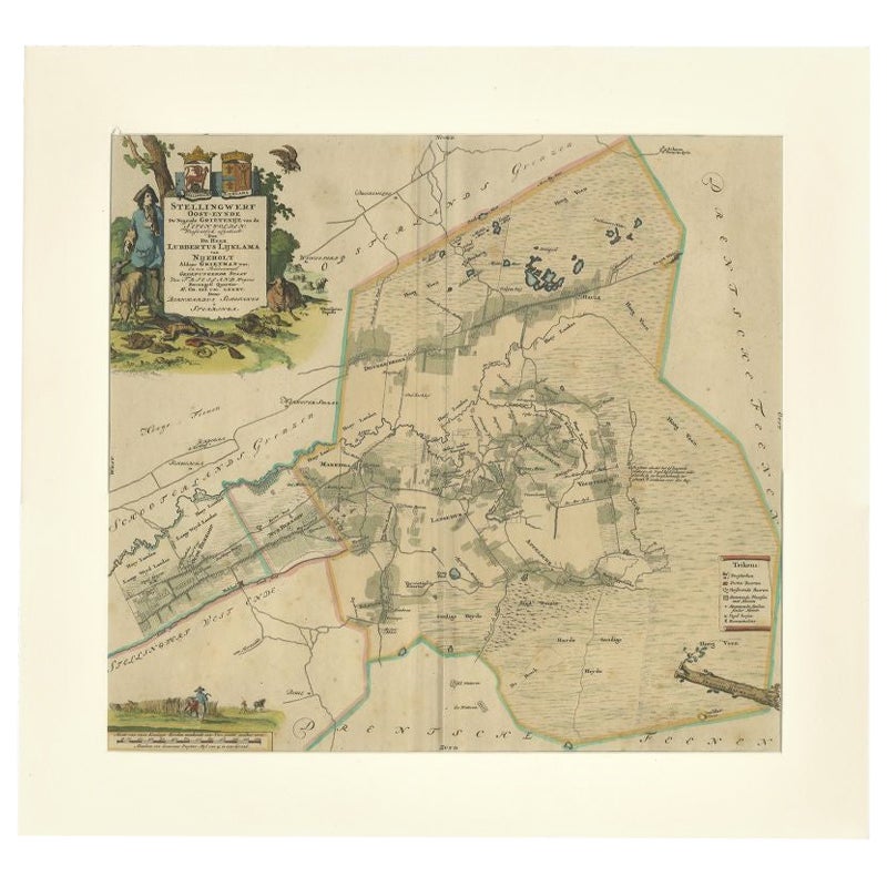
Antique Map of the Ooststellingwerf Township Friesland by Halma, 1718
Located in Langweer, NL
Antique map titled 'Stellingwerf Oost-Eynde, de negende Grietenije van de Sevenwolden'. This regional map of the Oost Stellingwerf Grietenij, part of the Province of Friesland, The N...
Category
Antique 18th Century Maps
Materials
Paper
$401 Sale Price
20% Off
Antique Map of Friesland by De Wit, c.1690
Located in Langweer, NL
Antique map titled 'Tabula Comitatus Frisiae'.
Old map of the province of Friesland, the Netherlands. With a small inset map of the Wadden area. Third state of the map by Schotan...
Category
Antique 17th Century Maps
Materials
Paper

$784 Sale Price
20% Off
Antique Map of Gaasterland in Friesland, the Netherlands, 1718
Located in Langweer, NL
Antique map titled 'Gaasterland. De zevende Grietenije van de Zevenwolden (..)'. Original antique map of Gaasterland, Friesland, the Netherlands. Originates from 'Uitbeelding van de ...
Category
Antique 18th Century Maps
Materials
Paper
$621 Sale Price
20% Off
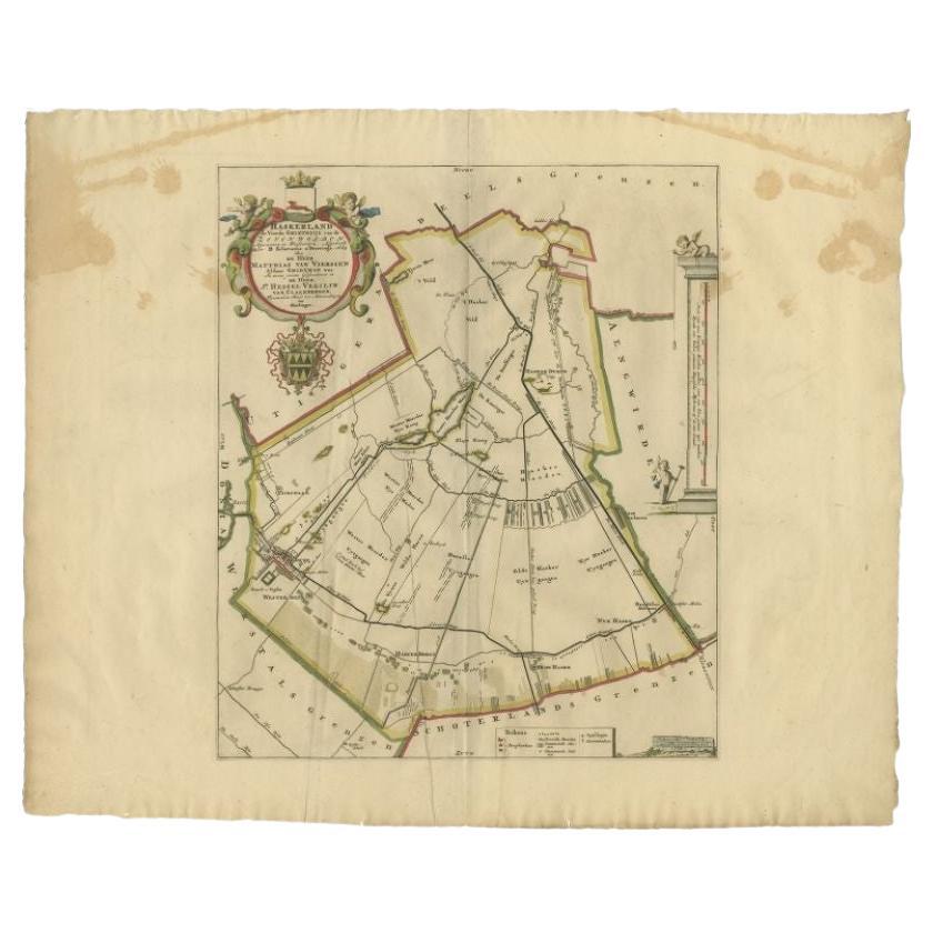
Antique Map of the Haskerland Township 'Friesland' by Halma, 1718
Located in Langweer, NL
Antique map Friesland titled 'Haskerland, de vierde Grietenije van de Zevenwolden (..)'. Old map of Friesland, the Netherlands. This map depicts the region of Haskerland and includes...
Category
Antique 18th Century Maps
Materials
Paper
$264 Sale Price
20% Off
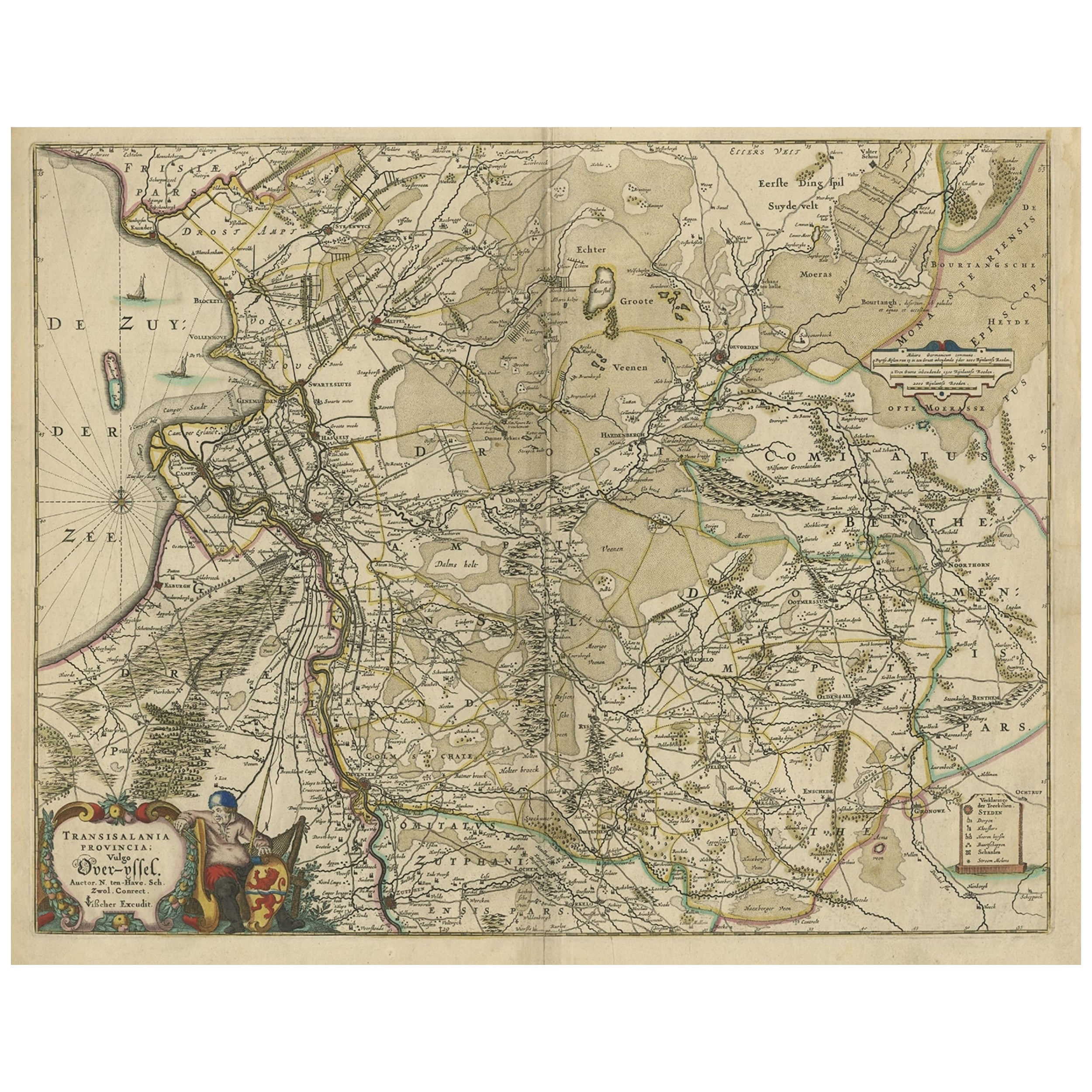
Attractive Original Map of the Province of Overijssel, the Netherlands, Ca.1700
Located in Langweer, NL
Antique print, titled: 'Transisalania Provincia vulgo Over-yssel.'
Attractive original handcoloured map of the province of Overijssel, The Netherlands. With beautiful title cartouc...
Category
Antique Early 1700s Maps
Materials
Paper
$896 Sale Price
40% Off
You May Also Like
Utrecht, Netherlands: A Large 17th Century Hand-colored Map by Sanson & Jaillot
By Nicholas Sanson d'Abbeville
Located in Alamo, CA
This large hand-colored map entitled "La Seigneurie d'Utrecht. Dressé sur les memoires les plus nouveaux par le Sr. Sanson" was originally created by Nicholas Sanson d'Abbeville. Thi...
Category
1690s Landscape Prints
Materials
Engraving

North Holland, Netherlands: A Large 17th C. Hand-colored Map by Sanson & Jaillot
By Nicholas Sanson d'Abbeville
Located in Alamo, CA
This large hand-colored map entitled "Le Comte De Hollande Dressee sur les Memoires les plus Nouveaux" was originally created by Nicholas Sanson d'Abbeville. This version was publish...
Category
1690s Landscape Prints
Materials
Engraving

Southern Holland: An Original 17th C. Hand-colored Visscher Map "Hollandiae"
By Nicolaus Visscher
Located in Alamo, CA
This a beautiful framed hand colored 17th century map of the southern portions of Holland by Nicolaus (Nicolas) Visscher II entitled "Hollandiae pars Meridionalis, vulgo Zuyd-Holland", published in Amsterdam in 1678. The map shows the region between Breda, Heusden, Gornichem, Gouda, Dordrecht, and Willemstad. It includes a decorative cartouche in the lower left corner.
The map is presented in an attractive maple colored wood frame with gold trim and a fabric mat. There is a central vertical fold, as issued. There are small areas of discoloration consistent with age. The map is otherwise in very good condition.
The Visscher family were one of the great cartographic families of the 17th century. Begun by Claes Jansz Visscher...
Category
Late 17th Century Other Art Style Landscape Prints
Materials
Engraving

Map of Oxfordshire coloured 18th century engraving by Thomas Kitchin
By Thomas Kitchin
Located in London, GB
To see our other original maps, scroll down to "More from this Seller" and below it click on "See all from this Seller" - or send us a message if you cannot find the poster you want....
Category
1760s Landscape Prints
Materials
Engraving

1752 Vaugoundy Map of Flanders : Belgium, France, and the Netherlands, Ric.a002
Located in Norton, MA
Large Vaugoundy Map of Flanders:
Belgium, France, and the Netherlands
Colored -1752
Ric.a002
Description: This is a 1752 Didier Robert de Vaugondy map of Flanders. The map de...
Category
Antique 17th Century Unknown Maps
Materials
Paper

Belgium and the Netherlands: A Hand-colored 17th Century Map by Visscher
By Nicolaus Visscher
Located in Alamo, CA
This is an original hand-colored 17th century map of Belgium by Nicolaus (Nicolas) Visscher II entitled "Belgium Foederatum emendate auctum et novissime editum", published in Amsterdam in 1678. The map shows the seven provinces comprising the Belgium federation or the Republic of the Seven United Netherlands or the Dutch Republic as it was also known. The republic was formed when an alliance of seven Dutch provinces in the Spanish Netherlands revolted against rule by Spain in 1579 (the Union of Utrecht) and declared their independence in 1581 (the Act of Abjuration). The seven provinces were Groningen, Frisia, Overijssel, Guelders, Utrecht, Holland and Zeeland. This was a predecessor state to the Netherlands and the first fully independent Dutch nation state. Amsterdam, Delft, Rouen, Utrecht, Brugge, Ghent, and Antwerp are all included on the map. A small inset map in the lower right depicts the course of the Maas River from Maastricht to Wessem. There is a decorative cartouche in the upper left corner and a distance scale cartouche in the lower right corner.
The map is presented in an attractive antiqued medium brown-colored wood frame with gold-colored inner and outer trim and a light tan-colored fabric mat. The frame measures 26.63" high by 30" wide by 0.75" deep. There is some darkening of the red areas in the map, presumably related to oxidation of the original iron containing pigment over time. There are also a few scattered spots. The map is otherwise in very good condition.
The Visscher family were one of the great cartographic families of the 17th century. Begun by Claes Jansz Visscher...
Category
Late 17th Century Other Art Style Landscape Prints
Materials
Engraving

More Ways To Browse
Mid Century Sofa Red
Painted Arm Chairs
Vintage Azerbaijan
Charles Rennie Mackintosh For Cassina
Painted Bar Stools
3x5 Rugs
French Iron And Glass Table
Mcm Table
Tufted Bar
Green Oushak
Pelle Pelle Leather
Antique Marble Top Hall Table
Bent Plywood
Antique Column Base
Bureau Desk
Low Black Coffee Table
Porcelain Modern Hand Painted
Dining Tables With Brass Inlay