Items Similar to Isle de Ladrones: Early 18th-Century Map of the Mariana Islands by F. Bernard


Want more images or videos?
Request additional images or videos from the seller
1 of 10
Isle de Ladrones: Early 18th-Century Map of the Mariana Islands by F. Bernard
$143.41
$179.2620% Off
£106.17
£132.7120% Off
€120
€15020% Off
CA$198.44
CA$248.0520% Off
A$218.75
A$273.4320% Off
CHF 114.46
CHF 143.0720% Off
MX$2,683.95
MX$3,354.9320% Off
NOK 1,440.80
NOK 1,801.0120% Off
SEK 1,347.38
SEK 1,684.2220% Off
DKK 913.68
DKK 1,142.1020% Off
About the Item
Isle de Ladrones: Early 18th-Century Map of the Mariana Islands by F. Bernard
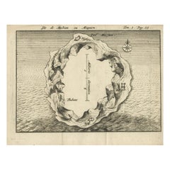
This intriguing copper engraving depicts the *Isle de Ladrones*, now known as the Mariana Islands, situated in the western Pacific Ocean. The map was published around 1722 in Amsterdam by F. Bernard as part of the influential travel compilation *Recueil des voyages qui ont servi a ...*. The map offers a simplistic yet stylized portrayal of the island, emphasizing its rugged and mountainous terrain, dotted with sparse vegetation and hills.
The term *Isle de Ladrones* (Islands of Thieves) was given by the Spanish explorer Ferdinand Magellan in 1521 during his circumnavigation of the globe, as his crew encountered thefts from the native Chamorro people. The name later changed to *Mariana Islands* when they were named after Queen Mariana of Austria in the 17th century. This map provides a unique glimpse into how European cartographers depicted remote and lesser-known territories during the early 18th century.
The engraving style features fine line work typical of early 18th-century cartography, with elegantly arranged tree and mountain symbols filling the island's surface. The map's composition appears intentionally stylized, focusing more on aesthetic appeal than precise geographical accuracy. The island’s shape is vaguely outlined, leaving much to the imagination, reflecting the limited knowledge of the area during that period.
The map was published in Amsterdam, a significant hub for cartographic production and exploration literature in the 17th and 18th centuries. The editor, F. Bernard, was known for assembling collections of travel narratives and exploratory accounts. This piece comes from his atlas *Recueil des voyages qui ont servi a ...*, which compiled various geographical and ethnographical descriptions to satisfy the growing European curiosity about distant lands.
The map’s historical value lies not only in its representation of the Mariana Islands but also in its cultural context as part of the European exploration and colonization efforts. Such maps served both as informative guides and decorative illustrations for scholarly and wealthy patrons, who took great interest in collecting maps and travel books as symbols of knowledge and curiosity.
Condition report: The engraving is in good condition, with clean, crisp lines and minimal foxing or staining. The paper has aged gracefully, retaining a warm, antique patina.
Framing tips: To best present this rare piece, consider framing it with a classic black or dark wood frame and a cream or light tan mat that complements the soft tones of the aged paper. This presentation will emphasize the historic and cartographic charm of the print while protecting it for future generations.
- Dimensions:Height: 6.5 in (16.5 cm)Width: 4.53 in (11.5 cm)Depth: 0.01 in (0.2 mm)
- Materials and Techniques:Paper,Engraved
- Period:1720-1729
- Date of Manufacture:circa 1722
- Condition:Condition report: The engraving is in good condition, with clean, crisp lines and minimal foxing or staining. The paper has aged gracefully, retaining a warm, antique patina.
- Seller Location:Langweer, NL
- Reference Number:Seller: BG-035231stDibs: LU3054344140762
About the Seller
5.0
Recognized Seller
These prestigious sellers are industry leaders and represent the highest echelon for item quality and design.
Platinum Seller
Premium sellers with a 4.7+ rating and 24-hour response times
Established in 2009
1stDibs seller since 2017
2,613 sales on 1stDibs
Typical response time: <1 hour
- ShippingRetrieving quote...Shipping from: Langweer, Netherlands
- Return Policy
Authenticity Guarantee
In the unlikely event there’s an issue with an item’s authenticity, contact us within 1 year for a full refund. DetailsMoney-Back Guarantee
If your item is not as described, is damaged in transit, or does not arrive, contact us within 7 days for a full refund. Details24-Hour Cancellation
You have a 24-hour grace period in which to reconsider your purchase, with no questions asked.Vetted Professional Sellers
Our world-class sellers must adhere to strict standards for service and quality, maintaining the integrity of our listings.Price-Match Guarantee
If you find that a seller listed the same item for a lower price elsewhere, we’ll match it.Trusted Global Delivery
Our best-in-class carrier network provides specialized shipping options worldwide, including custom delivery.More From This Seller
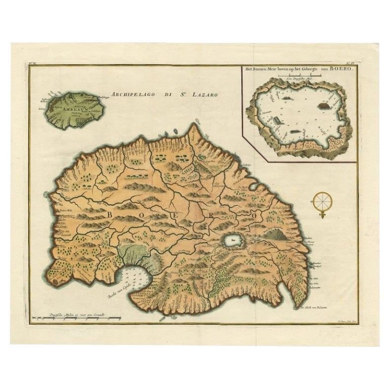
View AllAntique Map of Buru Island, Indonesia, c.1725
Located in Langweer, NL
Antique map titled 'Boero'. Original antique map of Buru island. With an inset of the lake on top of the inland mountain. This map originates from Valentyn's 'Oud en Nieuw Oost Indie...
Category
Antique 18th Century Maps
Materials
Paper

$525 Sale Price
20% Off
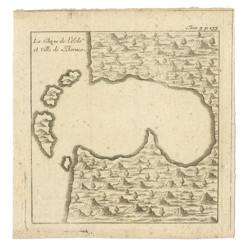
Antique Map of a Bay of Borneo, Indonesia, c.1760
Located in Langweer, NL
Antique map titled 'La Baye de l'isle et Ville de Borneo'. Small map depicting a Bay of Borneo.
Artists and Engravers: Anonymous.
Condition: Good, general age-related toning. Smal...
Category
Antique 18th Century Maps
Materials
Paper
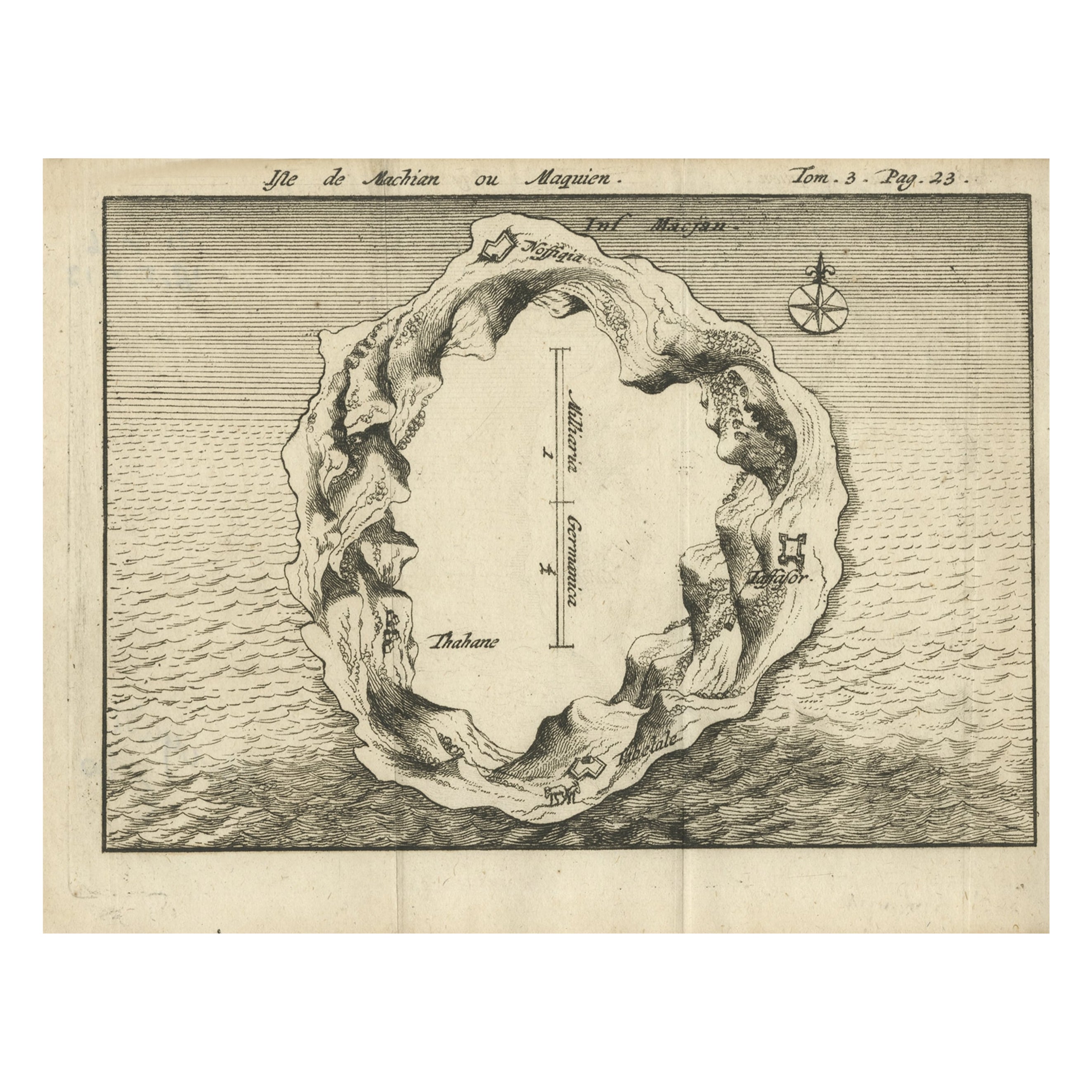
Antique Map of Macjan or Makian Island in the Moluccas, Indonesia, c.1740
Located in Langweer, NL
Antique map titled 'Isle de Machian ou Maquien'. Map of the island of Macjan, Moluccas. Source unknown, to be determined. Artists and Engravers: Anonymous.
Artist: Anonymous.
Con...
Category
Antique 18th Century Maps
Materials
Paper
$219 Sale Price
20% Off
Antique Map of Ambelau and Buru Island, Maluku or Moluccas in Indonesia, 1726
Located in Langweer, NL
Antique map titled 'Boero - Amblauw (..).' Detailed map of the Island Ambelau and Buru, Maluku Islands, Indonesia, by Francois Valentyn. With an inset of the lake on the Buru mountai...
Category
Antique 18th Century Maps
Materials
Paper

$353 Sale Price
20% Off
Antique Map of the Maluku Islands by Bellin, c.1750
By Jacques-Nicolas Bellin
Located in Langweer, NL
Antique map titled 'Carte Particuliere des Isles Moluques'. This map depicts the islands of Herij, Ternate, Tidor, Pottebackers, Timor, Machian and Bachian. The Moluccan islands were...
Category
Antique 18th Century Maps
Materials
Paper

$119 Sale Price
20% Off
Antique Map of Juan Fernandez Island by Anson '1749'
Located in Langweer, NL
Antique map titled 'l'Ile de Juan Fernandes dans la Mer du Sud (..) - Het Eiland Juan Fernandes in de Zuid Zee (..)'. This map depicts Juan Fernandez Island in the Southern Sea. This...
Category
Antique Mid-18th Century Maps
Materials
Paper

$191 Sale Price
20% Off
You May Also Like
1627 Hendrik Hondius Map Entitled "Vltoniae Orientalis Pars, " Ric.a009
Located in Norton, MA
1627 Hendrik Hondius map entitled
"Vltoniae orientalis pars,"
Ric.a009
Title:
Vltoniae orientalis : pars
Title (alt.) :
Ultoniae orientalis pars
Creator:
Mercator, Gerh...
Category
Antique 17th Century Dutch Maps
Materials
Paper

Rugen Island, Germany: An Early 17th Century Map by Mercator and Hondius
By Gerard Mercator
Located in Alamo, CA
This is an early 17th century map entitled "Nova Famigerabilis Insulae Ac Ducatus Rugiae Desciptio" (Map of Rugen Island, Germany) by Gerard Mercator and Henricus and Joducus Hondiu...
Category
Early 17th Century Old Masters Landscape Prints
Materials
Engraving

Ancient Map - Zeilan - Etching by Johannes Janssonius - 1650s
By Johannes Janssonius
Located in Roma, IT
Ancient Map - Zeilan is an ancient map realized in 1650 by Johannes Janssonius (1588-1664).
The Map is Hand-colored etching, with coeval watercoloring.
...
Category
1650s Modern Figurative Prints
Materials
Etching

Antique French Map of Asia Including China Indoneseia India, 1783
Located in Amsterdam, Noord Holland
Very nice map of Asia. 1783 Dedie au Roy.
Additional information:
Country of Manufacturing: Europe
Period: 18th century Qing (1661 - 1912)
Condition: Overall Condition B (Good Used)...
Category
Antique 18th Century European Maps
Materials
Paper

$648 Sale Price
20% Off
Antique Map - Mare Pacificum - Etching by Johannes Janssonius - 1650s
By Johannes Janssonius
Located in Roma, IT
Mare Pacificum is an antique map realized in 1650 by Johannes Janssonius (1588-1664).
The Map is Hand-colored etching, with coeval watercolorang.
Good conditions with slight foxing...
Category
1650s Modern Figurative Prints
Materials
Etching

1633 Map "La Souverainete De Sedan Et De Raucourt, Et La Prevoste Ric0011
Located in Norton, MA
1653 map entitled
"La Souverainete de Sedan et de Raucourt, et la Prevoste de Doncheri,"
Ric0011
Description:
Lovely map centered on Sedan and Doncheri and the Meuze River fr...
Category
Antique 17th Century Dutch Maps
Materials
Paper

More Ways To Browse
Paper Globe Light
Mariana Islands
Magellan 1521
Large Antique Tapestry
Mid Century Modern Corner Chair
Sterling Silver Flatware Set Service For 12
1970s Brass Glass Coffee Table
Mid Century Sofa Red
Painted Arm Chairs
Vintage Azerbaijan
Charles Rennie Mackintosh For Cassina
Painted Bar Stools
3x5 Rugs
French Iron And Glass Table
Mcm Table
Tufted Bar
Green Oushak
Pelle Pelle Leather