Items Similar to La Rioja 1901: A Cartographic Journey Through Spain's Renowned Wine Country


Want more images or videos?
Request additional images or videos from the seller
1 of 6
La Rioja 1901: A Cartographic Journey Through Spain's Renowned Wine Country
About the Item
The map for sale illustrates the province of La Rioja, with its capital Logroño, as of the year 1901. The map details various geographic and man-made features:
- **Topography**: It shows the diverse landscape of La Rioja, which includes parts of the Iberian System and the Ebro basin.
- **Hydrography**: Blue lines represent rivers, including the Ebro River, which is a significant feature in the region.
- **Transportation**: Red lines indicate roads and railways, highlighting the transportation infrastructure that connects La Rioja's towns and cities within the province and to other areas.
- **Urban Areas**: Symbols mark the locations of cities, towns, and villages, with the capital city, Logroño, presumably indicated.
- **Political Boundaries**: Dotted lines may delineate the administrative boundaries within the province.
- **Legend**: The map includes a legend (Signos Convencionales) explaining the symbols used for provincial capitals, roads, railways, and boundaries.
- **Scale**: A scale in kilometers at the bottom provides a reference for distance measurement.
- **Coat of Arms**: The coat of arms of Logroño is prominently displayed, incorporating symbols of the province's identity and heritage.
About the province of La Rioja:
La Rioja is most famous for its wine production, with the region being synonymous with some of Spain's finest red wines. The province's economy is heavily influenced by the viticulture industry, with numerous bodegas (wineries) that contribute to both the local and national economy. The landscape is characterized by vineyard-covered hills and the fertile valleys of the Ebro River. La Rioja's cultural heritage includes monasteries such as San Millán de la Cogolla, which are UNESCO World Heritage Sites and hold significant importance in the history of the Spanish language. The capital, Logroño, is known for its rich history, cultural events, and as a stopping point on the Camino de Santiago pilgrimage route. The cuisine of La Rioja includes dishes such as "patatas a la riojana" (potato and chorizo stew) and "pimientos rellenos" (stuffed peppers), which are often paired with the local wines.
- Dimensions:Height: 14.77 in (37.5 cm)Width: 20.08 in (51 cm)Depth: 0 in (0.02 mm)
- Materials and Techniques:
- Period:1900-1909
- Date of Manufacture:1901
- Condition:Good condition. Central vertical folding lines as issued. Aged paper with typically warm, yellowish-brown hue, especially around the edges. Check the images carefully.
- Seller Location:Langweer, NL
- Reference Number:
About the Seller
5.0
Platinum Seller
These expertly vetted sellers are 1stDibs' most experienced sellers and are rated highest by our customers.
Established in 2009
1stDibs seller since 2017
1,928 sales on 1stDibs
Typical response time: <1 hour
- ShippingRetrieving quote...Ships From: Langweer, Netherlands
- Return PolicyA return for this item may be initiated within 14 days of delivery.
More From This SellerView All
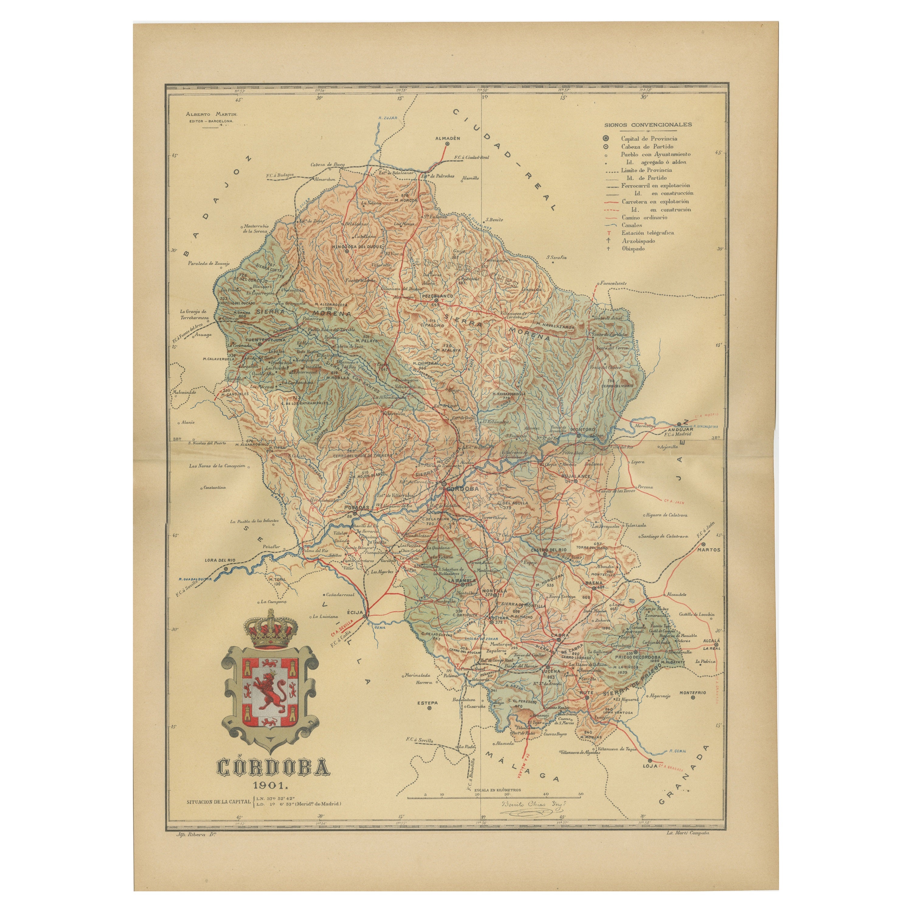
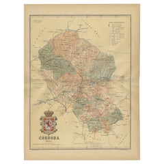
- Córdoba 1901: A Cartographic Journey Through Andalusia’s Heartland in SpainLocated in Langweer, NLThe map provided is of the province of Córdoba, part of the autonomous community of Andalusia in southern Spain, as of the year 1901. It details various elements: The map displays the varied terrain of Córdoba, including the Sierra Morena to the north and the beginning of the Subbaetic Range to the south. It shows blue lines indicating rivers, most likely including the Guadalquivir River, which runs through the province. Red lines represent the transportation network of roads and railways, detailing how the province is interconnected. Symbols on the map mark the locations of cities, towns, and villages, with the capital city of Córdoba highlighted. Dotted lines suggest the borders of the province within the region of Andalusia. A legend (Signos Convencionales) details the symbols used for provincial capitals, roads, railways, and other features. A scale in kilometers is included to assist in measuring distances between points on the map. The coat of arms of Córdoba is prominently featured, displaying a castle and a lion, which are common heraldic symbols with historical significance to the region. About the province of Córdoba: Córdoba is historically significant, known for its cultural heritage, particularly during the time when it was the capital of the Islamic Emirate and then Caliphate of Córdoba. This period left a lasting architectural mark, notably the Mezquita-Catedral (Mosque-Cathedral), which is a UNESCO World Heritage site. The province's geography is diverse, with fertile valleys in the Guadalquivir basin and extensive olive groves, making it one of the most important areas for olive oil production...Category
Antique Early 1900s Maps
MaterialsPaper
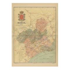
- 1902 Murcia: A Cartographic Snapshot of Spain's Southeastern ProvinceLocated in Langweer, NLThe map represents the province of Murcia, Spain, as it was in 1902. Here's an overview of its characteristics: - **Geography**: It displays the varied terrain of Murcia, from the c...Category
Antique Early 1900s Maps
MaterialsPaper
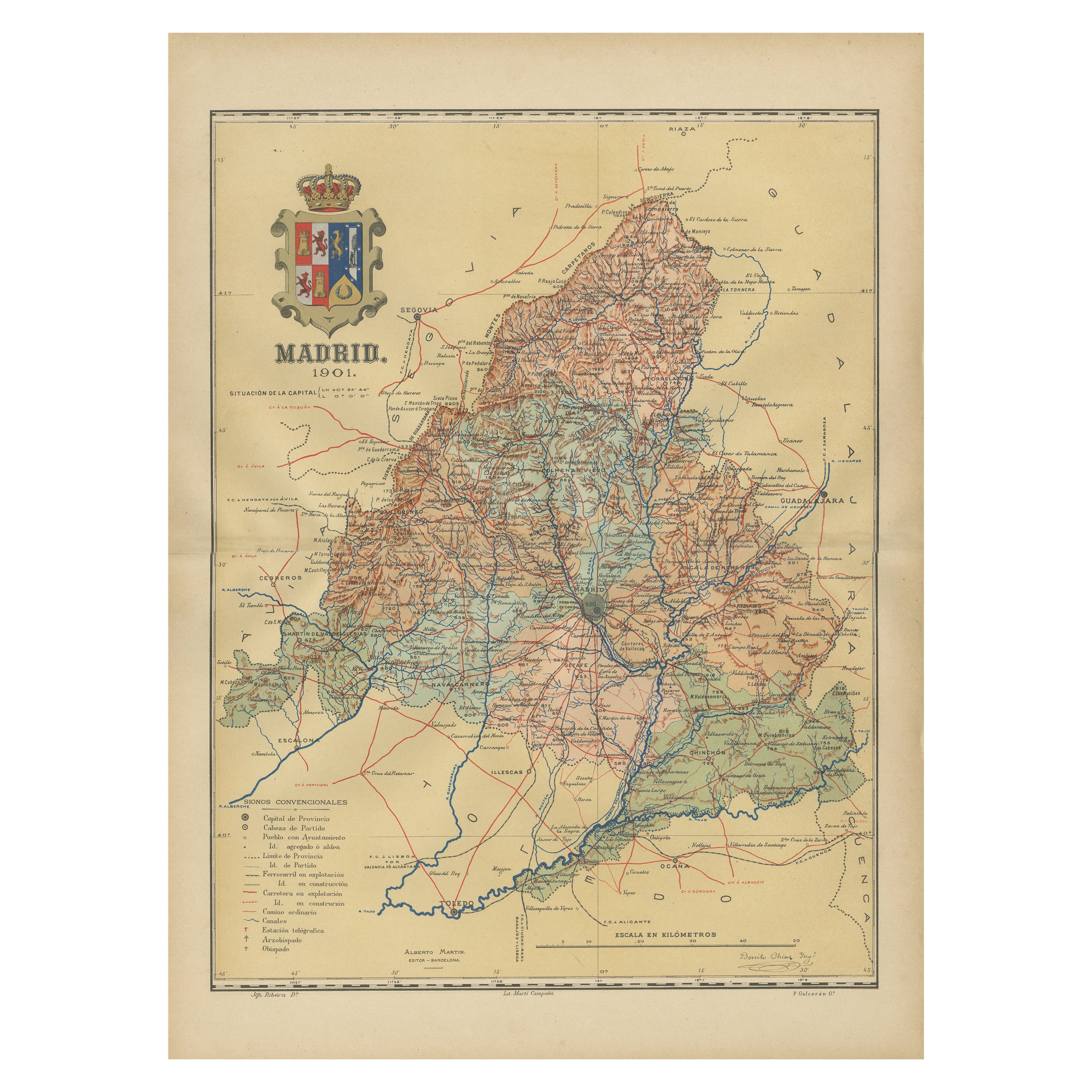
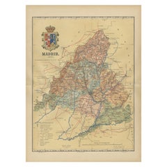
- Madrid 1901: A Historical Map of Spain's Capital ProvinceLocated in Langweer, NLThe map is of the province of Madrid, the capital region of Spain, as it appeared in 1901. Here are the key features it displays: The map shows the central part of Spain, with the Guadarrama mountain range prominently visible, marking the natural border to the north of Madrid. Blue lines likely indicate rivers, including the Manzanares River, which flows through Madrid, and the Jarama River, a tributary to the Tagus. Red lines depict the roads and railways, outlining the infrastructure that connects Madrid's various towns and cities within the province and beyond. Symbols and labels mark the locations of cities, towns, and villages, with Madrid itself likely being the focal point. Dotted lines may represent the administrative divisions within the province. The map includes a legend (Signos Convencionales) that explains the symbols used for provincial capitals, roads, railways, and other geographic features. The coat of arms of Madrid, featuring a bear and a strawberry tree (madroño), is prominently featured, symbolizing the city's and the province's historical coat of arms. About the province of Madrid: Madrid is not only the capital of Spain but also the heart of the Iberian Peninsula, both geographically and politically. The city is renowned for its rich repositories of European art, including the Prado Museum's works by Goya, Velázquez, and other Spanish masters. The province of Madrid is characterized by a blend of historical and modern elements, with a rich cultural life that includes theater, opera, and flamenco, as well as gastronomy that features a mix of traditional Spanish dishes and international cuisine...Category
Antique Early 1900s Maps
MaterialsPaper
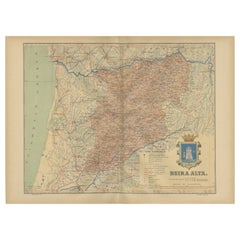
- Beira Alta: A Cartographic Journey Through Portugal's Heartland in 1903Located in Langweer, NLThe uploaded image is a historical map of the Beira Alta region in Portugal. The map is detailed, showing the topography, hydrography, and transportation networks of the region, incl...Category
Antique Early 1900s Maps
MaterialsPaper
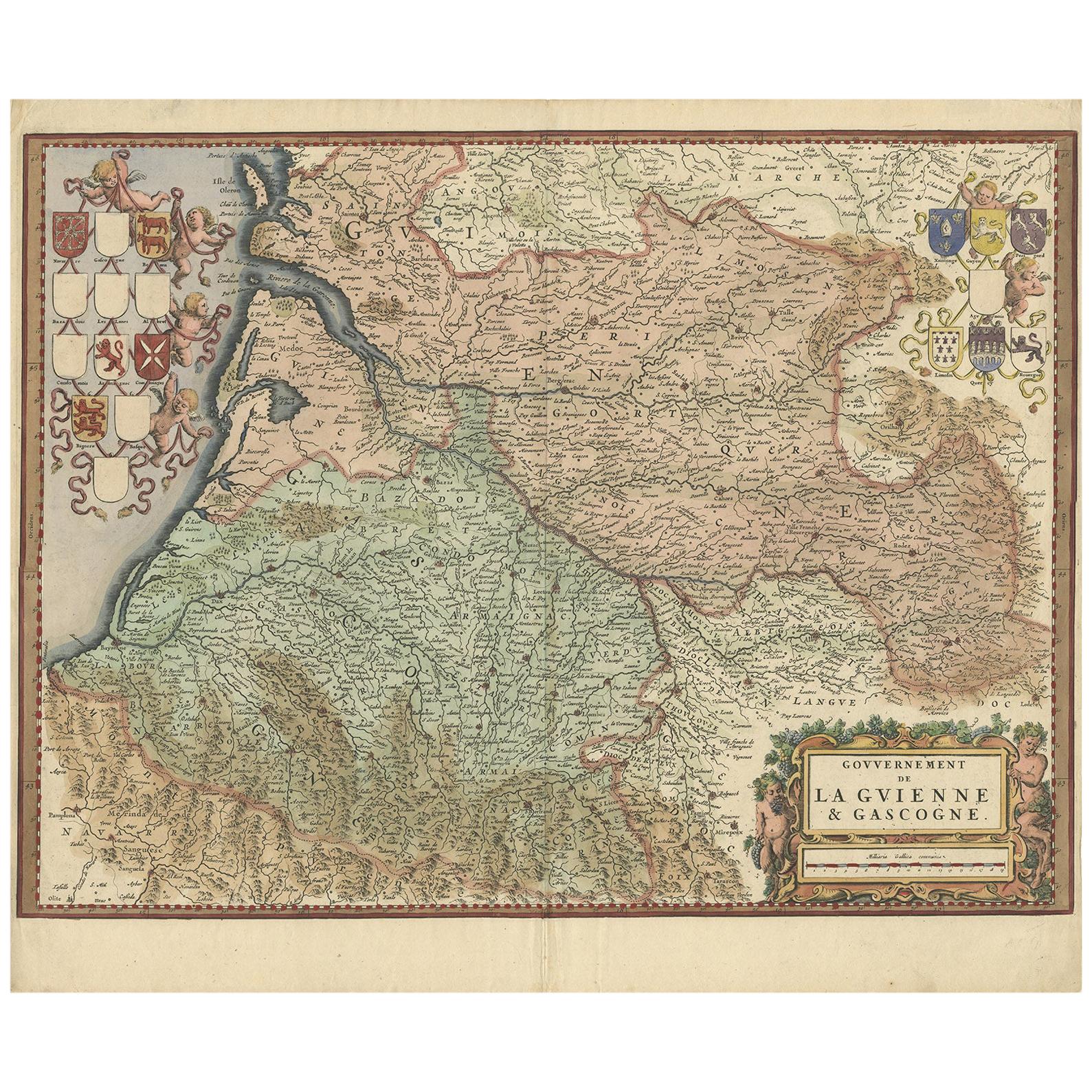
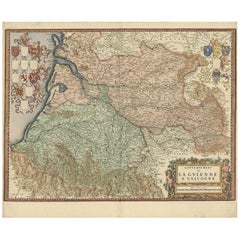
- Cartographic Treasures: A Journey Through the Gascogne and Guyenne Regions, 1680Located in Langweer, NLThe antique map titled "Gouvernement de La Guienne & Gascogne" depicts the region of Gascogne and Guyenne, known for their wine production, in France. This map is a rare edition, u...Category
Antique Late 17th Century Maps
MaterialsPaper
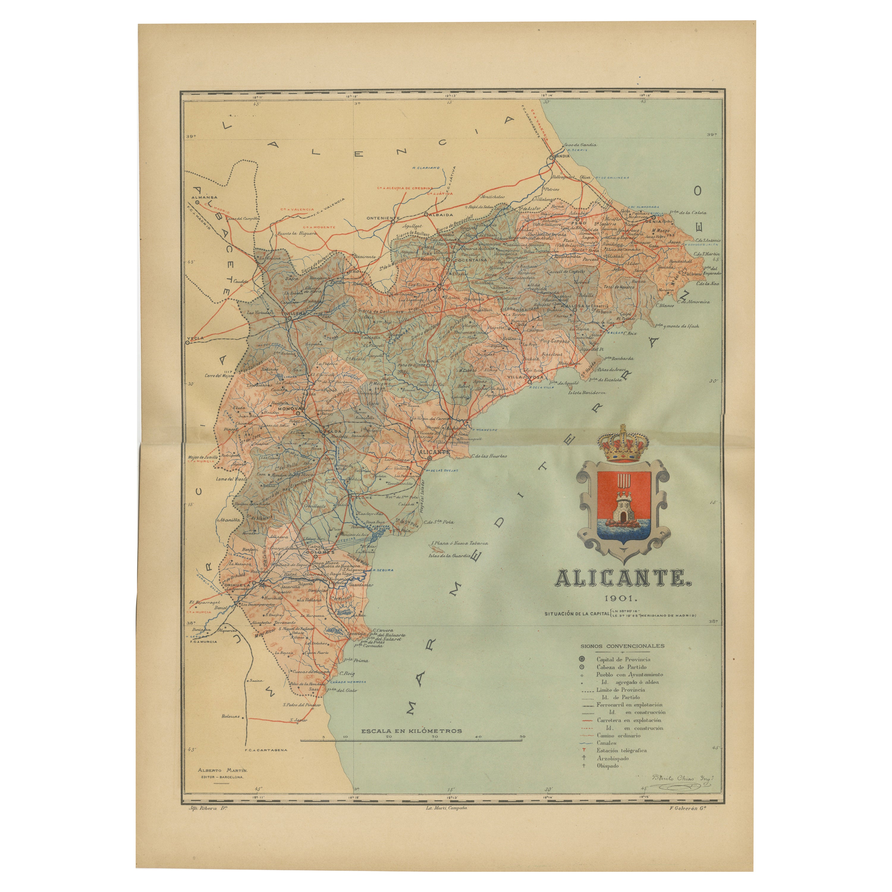
- Alicante in a 1901 Antique Map: Maritime Gateway of Spain's Costa BlancaLocated in Langweer, NLAn original antique map of the province of Alicante, dated 1901. It is part of the atlas series by D. Benito Chias y Carbo, featuring cartographic elements. Here are some characteri...Category
Antique Early 1900s Maps
MaterialsPaper

You May Also Like
- Ikoyi: A Journey Through Bold Heat with RecipesLocated in New York City, NY‘In what seems like only a brief moment, Ikoyi has shaken the world of cooking – René Redzepi, chef & co-owner of noma The exciting debut cookbook from the acclaimed chef of the t...Category
21st Century and Contemporary Chinese Books
MaterialsPaper
- Mexican A Journey Through Design Book by Newell TurnerLocated in New York, NYMexican A Journey Through Design By: Newell Turner Foreword by Susana OrdovasAn American expat searches vibrant cities and quiet pueblos for the essence of Mexican style Revealing the richly visual and cultural details that are the essence of Mexican style, design editor and photographer Newell Turner has done for Mexican design what legendary culinary pioneer Diana Kennedy did for Mexican food. Elegantly organized around nine decisive decorative periods that have shaped México’s unique design journey to the present day, Turner establishes a visual dialogue with the reader that beautifully captures the depth and subtleties of the country’s aesthetic legacy. Ushered behind the walls, gates, and doors of private México, we are introduced to an intriguing world of interior design and architecture—including the highly developed civilizations pre-dating the arrival of Columbus; the Spanish colonial arts; the dynamic response to global movements such as Art Deco and Surrealism; and a rich survey of modernist and contemporary work. Woven intricately into this history is Turner’s own story of discovering the distinctive soul of México, where —in the spirit of memoirs in which a traveler discovers another country —he finds himself along the way. In this vivid volume of color, texture and contrasts, Turner examines the extraordinary range of Mexican design with the insight of a true devotee. The breathtaking photography shows how every room, courtyard, loggia—and even a chair, or an arrangement of flowers—are part of a rich design heritage. Turner spent his magazine career chronicling American style, and now his unerring eye...Category
21st Century and Contemporary Books
MaterialsPaper
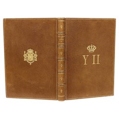
- Ortega-Morejon, Cuentos De Color De Lila, Queen Isabella II of Spain's Copy 1887Located in Hillsborough, NJAuthor: ORTEGA-MOREJON, Jose Maria De. Title: Cuentos De Color De Lila Y Fragmentos Sin Color. Publisher: Madrid: Miguel Ginesta, Impresor De La Real Casa, 1887. Description: First Edition, presentation copy, from the library of Queen Isabella II of Spain. 1 vol., 8-3/8" x 5-15/16", inscribed on the half-title to Queen Isabella by Ortega-Morejon "Isabel II, gloriosa Soberana de los espanoles", bound in full tan morocco, ribbed gilt decorated spine, covers ruled in gilt, gilt crown and initials of the Queen to the front cover, gilt crest to the rear cover, gilt dentelles, white silk morie doublures and endpapers, all edges gilt. Condition: Internally clean and bright, hinges fine, head and foot of spine fine, overall Very good. Additional information: Isabella II (10 October 1830 – 9 April 1904), was Queen of Spain from 29 September 1833 until 30 September 1868. Shortly before her birth, the King Ferdinand VII...Category
Antique 1880s Spanish Books
MaterialsLeather
- Journey into FearLocated in London, GBOriginal American photographic production still. For the 1942 Film Noir Journey into Fear. The film starred Joseph Cotten, Dolores Del Rio, Orson Welles ...Category
Vintage 1940s American Posters
MaterialsPaper
- Antique Technical Drawing Set, German, Architect, Cartography, WichmannLocated in Hele, Devon, GBThis is an antique technical drawing set. A German, architect's or cartographer's instrument case by Wichmann, dating to the early 20th c...Category
Early 20th Century German Edwardian Scientific Instruments
MaterialsNickel
- Antique Lithography Map, Lincolnshire, English, Framed, Engraving, CartographyLocated in Hele, Devon, GBThis is an antique lithography map of Lincolnshire. An English, framed atlas engraving of cartographic interest, dating to the mid 19th century and...Category
Antique Mid-19th Century British Victorian Maps
MaterialsWood


Recently Viewed
View AllMore Ways To Browse
Map Of Old Armenia
Teak Wood Sphere
Nova Guinea Maps
Antique Map Of Illinois
Petite Point Hand Bag
Antique Map Of Southeastern Us
Antique Map Alabama
Antique Map Of Sydney
Malay Archipelago Map
Gambia Antique Map
Uruguay Antique Map
Guyana Antique Map
Ruscelli Map
Masque Theatre No
Nova Scotia Map
Antique Map Tuscany
Berkshire Antique Map
Cornwall Map