Items Similar to Map of Saint Helena Island: Early 18th-Century Copper Engraving by F. Bernard


Want more images or videos?
Request additional images or videos from the seller
1 of 10
Map of Saint Helena Island: Early 18th-Century Copper Engraving by F. Bernard
$142.86
$178.5720% Off
£106.18
£132.7320% Off
€120
€15020% Off
CA$197.25
CA$246.5620% Off
A$218.73
A$273.4220% Off
CHF 114.93
CHF 143.6620% Off
MX$2,672.54
MX$3,340.6820% Off
NOK 1,437.90
NOK 1,797.3820% Off
SEK 1,349.72
SEK 1,687.1520% Off
DKK 913.74
DKK 1,142.1720% Off
About the Item
Map of Saint Helena Island: Early 18th-Century Copper Engraving by F. Bernard
This rare and beautifully detailed copper engraving of Saint Helena Island dates from around 1722 and was published in Amsterdam by F. Bernard as part of the renowned atlas *Recueil des voyages qui ont servi à...*. This work is a compilation of travel accounts and geographical discoveries, reflecting the growing European fascination with distant and isolated places during the Age of Exploration.
Saint Helena, a remote volcanic island in the South Atlantic Ocean, gained significant historical importance as a strategic stopover point for ships sailing between Europe and Asia. Most famously, it later became the place of exile for Napoleon Bonaparte from 1815 until his death in 1821.
The map’s design reflects the early cartographic style of the period, with the island’s rugged terrain depicted through bold line work and finely engraved mountain symbols. The interior of the island is dominated by a complex array of hills and peaks, giving the viewer a sense of its dramatic and varied landscape. Sparse clusters of trees and small symbols representing buildings, labeled as 'Pomar,' are scattered across the terrain, indicating settlements or cultivated areas.
At the top of the map are two inset profiles depicting the island as seen from the sea: 'Coste D’occident' (West Coast) and 'Coste du Nord' (North Coast). These coastal profiles were commonly included in early maps to aid navigators in identifying land from a distance. The simplistic and almost schematic representation of the coastlines reflects the limited geographical knowledge of the time, yet the engraver has meticulously crafted these views to offer practical guidance.
This map exemplifies the craftsmanship of early 18th-century cartography, with a distinct artistic touch that enhances its historical value. The title inscription at the top right, 'Tomi:2.p.120.', indicates that it comes from the second volume of the atlas, pointing to the structured compilation of explorative narratives and geographical representations.
Condition: The engraving is in good condition for its age, with clear, sharp lines and minimal signs of wear. The paper shows only light toning and a few minor foxing spots, typical of early 18th-century prints.
Framing tips: To display this rare and historically significant piece, consider framing it with a classic dark wood or ebony frame and a neutral or cream-colored mat to highlight the fine details and antique charm.
- Dimensions:Height: 6.23 in (15.8 cm)Width: 5.12 in (13 cm)Depth: 0.01 in (0.2 mm)
- Materials and Techniques:Paper,Engraved
- Period:1720-1729
- Date of Manufacture:circa 1722
- Condition:The engraving is in good condition for its age, with clear, sharp lines and minimal signs of wear. The paper shows only light toning and a few minor foxing spots, typical of early 18th-century prints.
- Seller Location:Langweer, NL
- Reference Number:Seller: BG-035221stDibs: LU3054344140872
About the Seller
5.0
Recognized Seller
These prestigious sellers are industry leaders and represent the highest echelon for item quality and design.
Platinum Seller
Premium sellers with a 4.7+ rating and 24-hour response times
Established in 2009
1stDibs seller since 2017
2,609 sales on 1stDibs
Typical response time: <1 hour
- ShippingRetrieving quote...Shipping from: Langweer, Netherlands
- Return Policy
Authenticity Guarantee
In the unlikely event there’s an issue with an item’s authenticity, contact us within 1 year for a full refund. DetailsMoney-Back Guarantee
If your item is not as described, is damaged in transit, or does not arrive, contact us within 7 days for a full refund. Details24-Hour Cancellation
You have a 24-hour grace period in which to reconsider your purchase, with no questions asked.Vetted Professional Sellers
Our world-class sellers must adhere to strict standards for service and quality, maintaining the integrity of our listings.Price-Match Guarantee
If you find that a seller listed the same item for a lower price elsewhere, we’ll match it.Trusted Global Delivery
Our best-in-class carrier network provides specialized shipping options worldwide, including custom delivery.More From This Seller
View AllAntique Map of Buru Island, Indonesia, c.1725
Located in Langweer, NL
Antique map titled 'Boero'. Original antique map of Buru island. With an inset of the lake on top of the inland mountain. This map originates from Valentyn's 'Oud en Nieuw Oost Indie...
Category
Antique 18th Century Maps
Materials
Paper

$523 Sale Price
20% Off
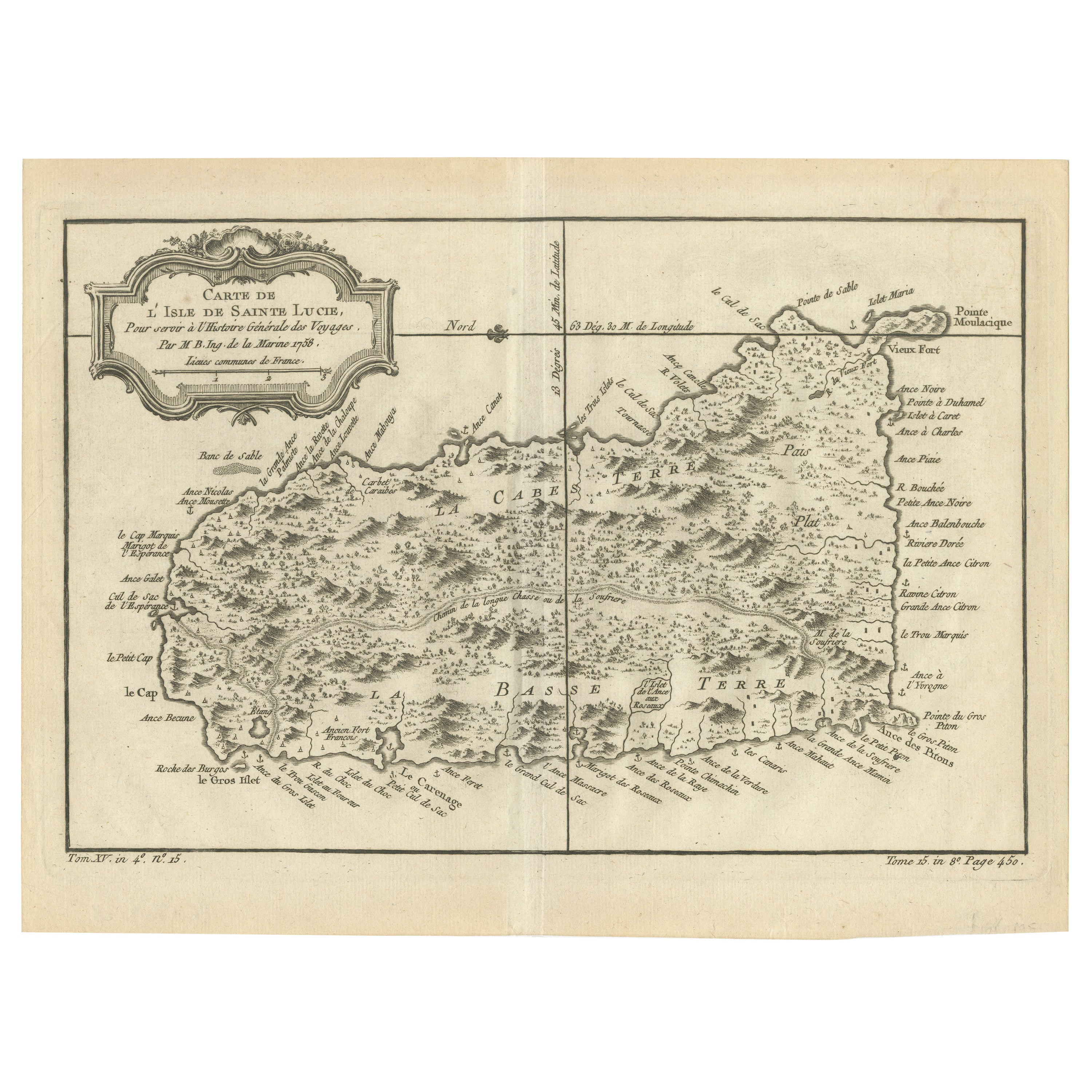
Original Engraved Map of Saint Lucia in the West Indies by Bellin, 1758
Located in Langweer, NL
The "Carte de L’Isle de Sainte Lucie" by Jacques Nicolas Bellin, a prominent figure as the Royal Hydrographer and engineer of the French Navy, is a remarkable antique map showcasing ...
Category
Antique 1750s Maps
Materials
Paper
$323 Sale Price
20% Off
Antique Map of Juan Fernandez Island by Anson '1749'
Located in Langweer, NL
Antique map titled 'l'Ile de Juan Fernandes dans la Mer du Sud (..) - Het Eiland Juan Fernandes in de Zuid Zee (..)'. This map depicts Juan Fernandez Island in the Southern Sea. This...
Category
Antique Mid-18th Century Maps
Materials
Paper

$190 Sale Price
20% Off
Antique Map of Juan Fernandez Island by Anson, c.1740
Located in Langweer, NL
Antique map titled 'Plan de la Côte du N.E. de l 'Ile de Juan Fernandes'.
Map of the northeast coast of the island of Juan Fernandez with Cumberland Bay, South America. In 1740 Ans...
Category
Antique 18th Century Maps
Materials
Paper

$228 Sale Price
20% Off
Antique Map of Anjouan Island by Valentijn, 1726
By F. Valentijn
Located in Langweer, NL
Antique map titled 'Anzuany'. This map depicts the island of Anjouan, one of the Comoros islands situated between Madagascar and Africa. The map is oriented with north to the left wi...
Category
Antique Early 18th Century Dutch Maps

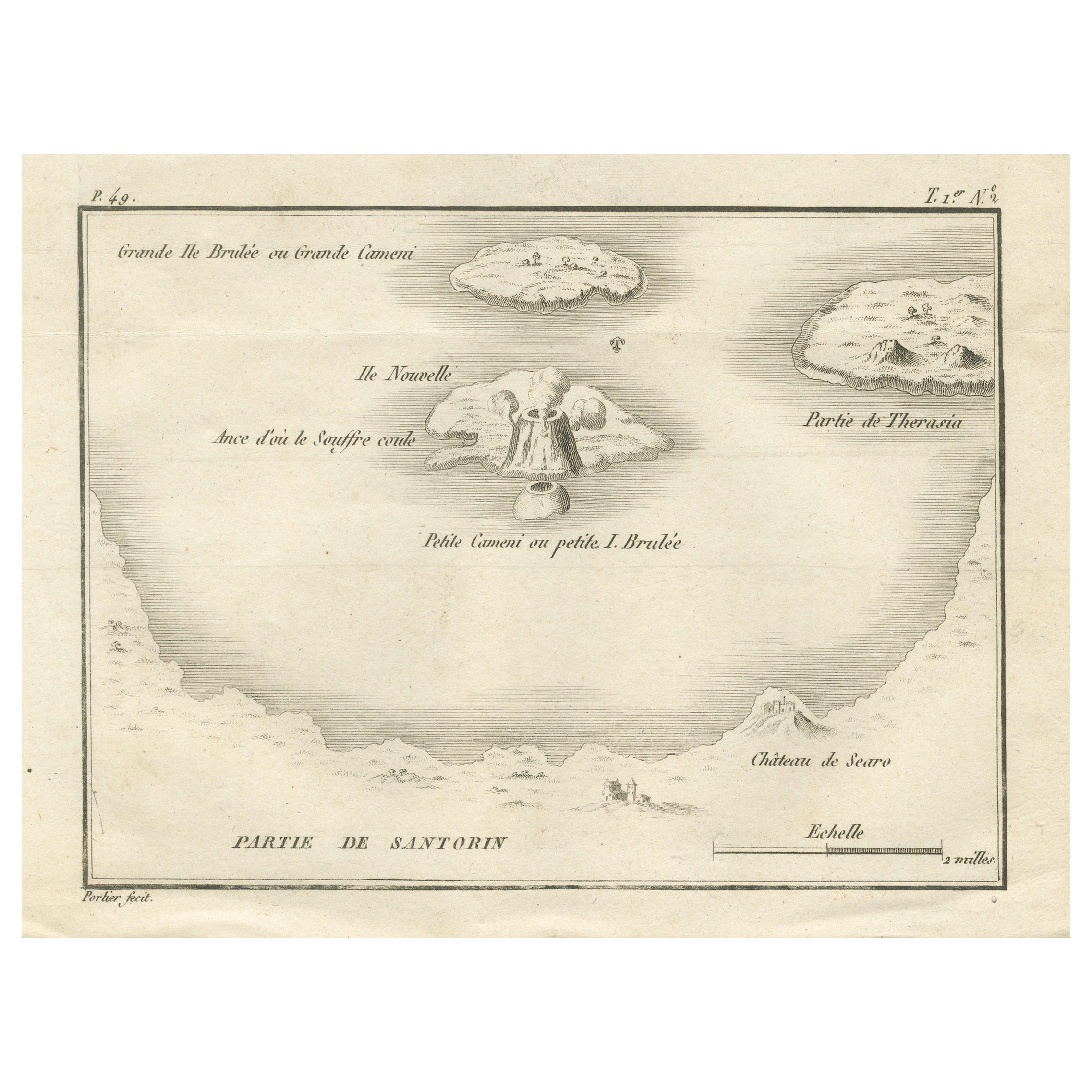
Map of the Volcano Islands of Santorini – Antique Engraving by Portier, ca.1790
Located in Langweer, NL
Map of the Volcano Islands of Santorini – Antique French Engraving by Portier, c.1790
This antique French engraving presents a detailed view of the volcanic islands at the center of...
Category
Antique Late 18th Century French Maps
Materials
Paper
You May Also Like
Ancient Map - Zeilan - Etching by Johannes Janssonius - 1650s
By Johannes Janssonius
Located in Roma, IT
Ancient Map - Zeilan is an ancient map realized in 1650 by Johannes Janssonius (1588-1664).
The Map is Hand-colored etching, with coeval watercoloring.
...
Category
1650s Modern Figurative Prints
Materials
Etching

Antique Map - Gallia - Etching by Johannes Janssonius - 1650s
By Johannes Janssonius
Located in Roma, IT
Antique Map - Gallia is an antique map realized in 1650 by Johannes Janssonius (1588-1664).
The Map is Hand-colored etching, with coeval watercoloring.
Good conditions with slight ...
Category
1650s Modern Figurative Prints
Materials
Etching

Antique Map - Mar Di Athiopia - Etching by Johannes Janssonius - 1650s
By Johannes Janssonius
Located in Roma, IT
Antique Map - Mar Di Athiopia is an antique map realized in 1650 by Johannes Janssonius (1588-1664).
The Map is Hand-colored etching, with coeval watercolorang.
Good conditions wit...
Category
1650s Modern Figurative Prints
Materials
Etching

Antique Map - Mare Pacificum - Etching by Johannes Janssonius - 1650s
By Johannes Janssonius
Located in Roma, IT
Mare Pacificum is an antique map realized in 1650 by Johannes Janssonius (1588-1664).
The Map is Hand-colored etching, with coeval watercolorang.
Good conditions with slight foxing...
Category
1650s Modern Figurative Prints
Materials
Etching

Original Antique Map of Switzerland, Engraved By Barlow, Dated 1807
Located in St Annes, Lancashire
Great map of Switzerland
Copper-plate engraving by Barlow
Published by Brightly & Kinnersly, Bungay, Suffolk.
Dated 1807
Unframed.
Category
Antique Early 1800s English Maps
Materials
Paper

St. Christophe (St. Kitts): Bellin 18th Century Hand Colored Map
Located in Alamo, CA
Jacques Bellin's copper-plate map of the Caribbean island of Saint Kitts entitled "Carte De De l'Isle St. Christophe Pour servir á l'Histoire Genle. des V...
Category
1740s Other Art Style Landscape Prints
Materials
Engraving

More Ways To Browse
Antique Copper Engravings
18th Century Copper
Napoleon Engraving
Vintage Scandanavian Chairs
19th Century Red Glass
Antique French Console Table Tables
Silver Bowl Large
Antique French Silk
Down Couch
Used Lighter Art
Blue Edge Glass
Mahogany 1950s Furniture
Solid Mahogany Table
Dessert Glasses
Geometric Glass Table
Mid Century Pin
6x10 Rug
Studded Furniture