Items Similar to Map of Western United States 1903 – Railroads, State Borders, and Terrain

Want more images or videos?
Request additional images or videos from the seller
1 of 11
Map of Western United States 1903 – Railroads, State Borders, and Terrain
$406.51
£300.94
€340
CA$562.51
A$620.15
CHF 324.44
MX$7,608.11
NOK 4,084.10
SEK 3,819.28
DKK 2,589.91
About the Item
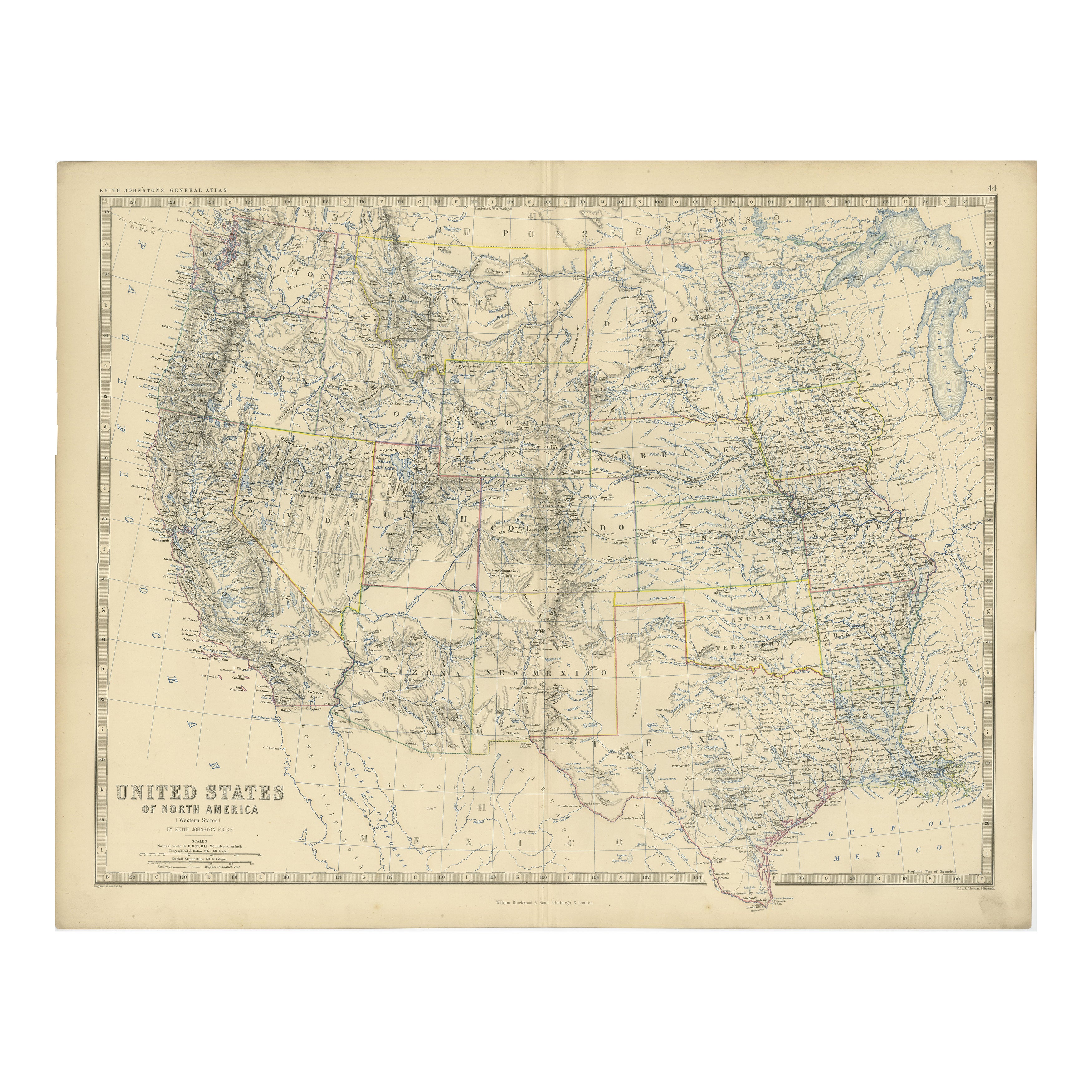
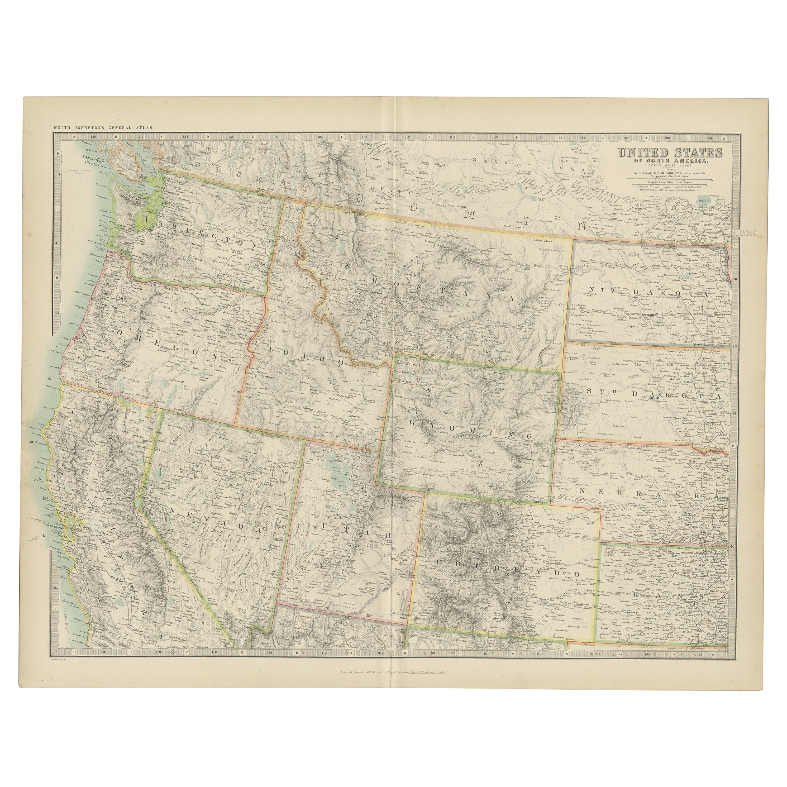
Map of Western United States 1903 – Railroads, State Borders, and Terrain
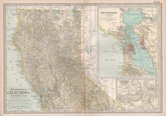
This beautifully engraved map titled "United States of North America (Western Sheet)" was created by Keith Johnston and published by W. & A.K. Johnston, Ltd. in London and Edinburgh, around 1903. It captures the western portion of the United States during a transformative period, showcasing states such as California, Oregon, Washington, Nevada, Idaho, Utah, Arizona, New Mexico, and parts of Montana, Wyoming, and Colorado.
This map is rich with historical detail, including an intricate network of railroads, key to the development of the western frontier in the early 20th century. State and county boundaries are carefully colored, while major rivers, mountain ranges, and settlements are precisely engraved, offering a glimpse into the growth of infrastructure and commerce. The typography is clean and refined, with town names, mountain peaks, and railway lines meticulously labeled.
Particularly interesting is the depiction of topography through delicate hachuring and shading, which brings the rugged beauty of the western landscape to life. The map also hints at the political and economic aspirations of the era, reflecting the westward expansion that defined the American experience.
The condition of this map is excellent for its age, with light toning around the edges and crisp, vibrant color that highlights the states and regions. It retains its charm and historical significance, making it a remarkable addition to any collection of antique maps or Americana.
For framing, a classic wooden frame in dark or natural tones would complement the historical aesthetic, while a neutral cream or soft tan mat would allow the detailed engravings to stand out. This map would make a wonderful centerpiece in an office, library, or living space, celebrating the rich heritage of the American West.
- Dimensions:Height: 18.51 in (47 cm)Width: 14.49 in (36.8 cm)Depth: 0.01 in (0.2 mm)
- Materials and Techniques:
- Period:
- Date of Manufacture:1903
- Condition:The condition is excellent for its age, with light toning around the edges and crisp, vibrant color that highlights the states and regions. It retains its charm and historical significance, making it a remarkable addition to any collection.
- Seller Location:Langweer, NL
- Reference Number:Seller: BG-13577-481stDibs: LU3054345291982
About the Seller
5.0
Recognized Seller
These prestigious sellers are industry leaders and represent the highest echelon for item quality and design.
Platinum Seller
Premium sellers with a 4.7+ rating and 24-hour response times
Established in 2009
1stDibs seller since 2017
2,613 sales on 1stDibs
Typical response time: <1 hour
- ShippingRetrieving quote...Shipping from: Langweer, Netherlands
- Return Policy
Authenticity Guarantee
In the unlikely event there’s an issue with an item’s authenticity, contact us within 1 year for a full refund. DetailsMoney-Back Guarantee
If your item is not as described, is damaged in transit, or does not arrive, contact us within 7 days for a full refund. Details24-Hour Cancellation
You have a 24-hour grace period in which to reconsider your purchase, with no questions asked.Vetted Professional Sellers
Our world-class sellers must adhere to strict standards for service and quality, maintaining the integrity of our listings.Price-Match Guarantee
If you find that a seller listed the same item for a lower price elsewhere, we’ll match it.Trusted Global Delivery
Our best-in-class carrier network provides specialized shipping options worldwide, including custom delivery.More From This Seller
View All1874 Map of Western United States – Detailed Atlas by Keith Johnston
Located in Langweer, NL
1874 Map of Western United States by Keith Johnston – Detailed Atlas
This is an original antique map titled “United States of North America (Western States)” by Alexander Keith John...
Category
Antique 1870s Scottish Maps
Materials
Paper

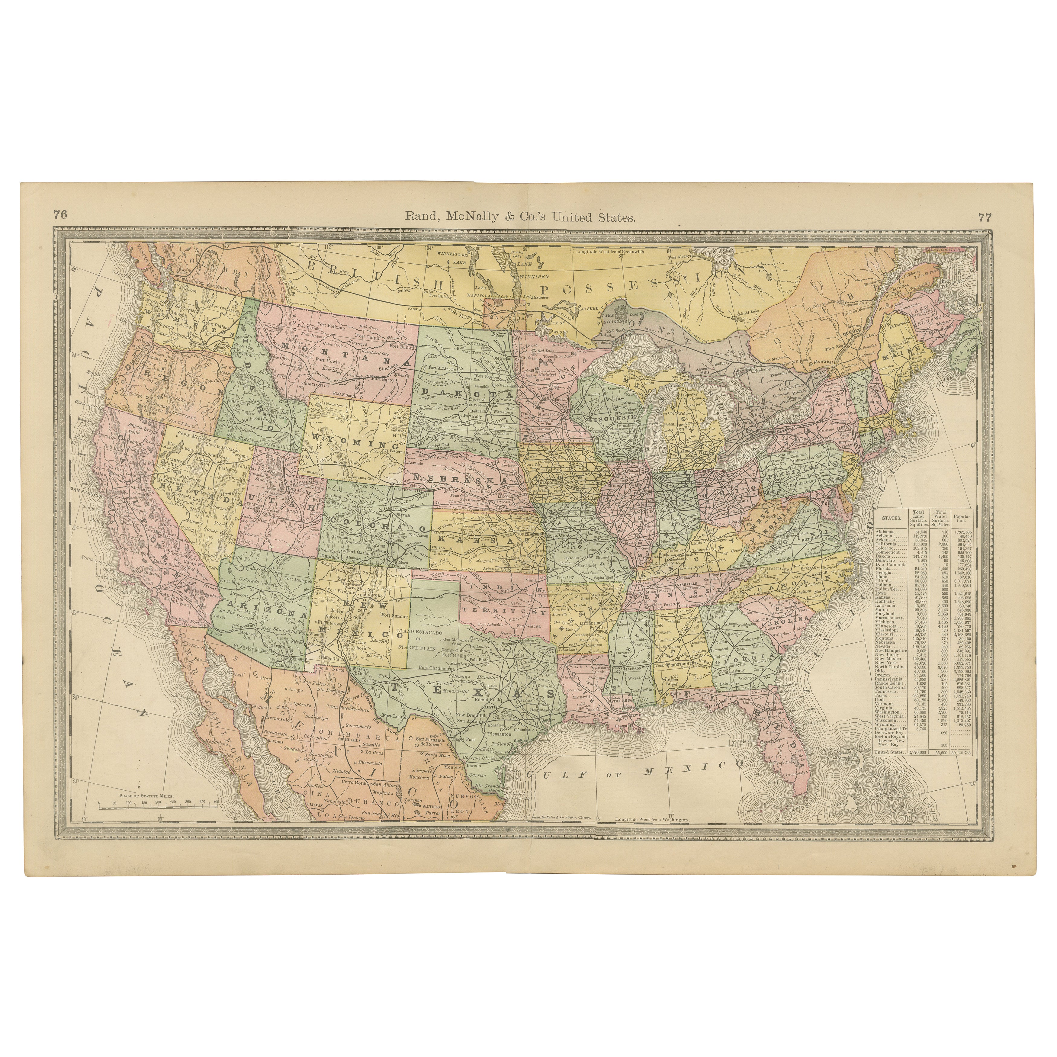
United States Antique Map c.1888 – Railroads, Territories & State Stats
Located in Langweer, NL
Antique Map of the United States – Rand McNally, circa 1888
This antique map of the United States was published by Rand, McNally & Co. around 1888. It presents a colorful overview o...
Category
Antique Late 19th Century American Maps
Materials
Paper
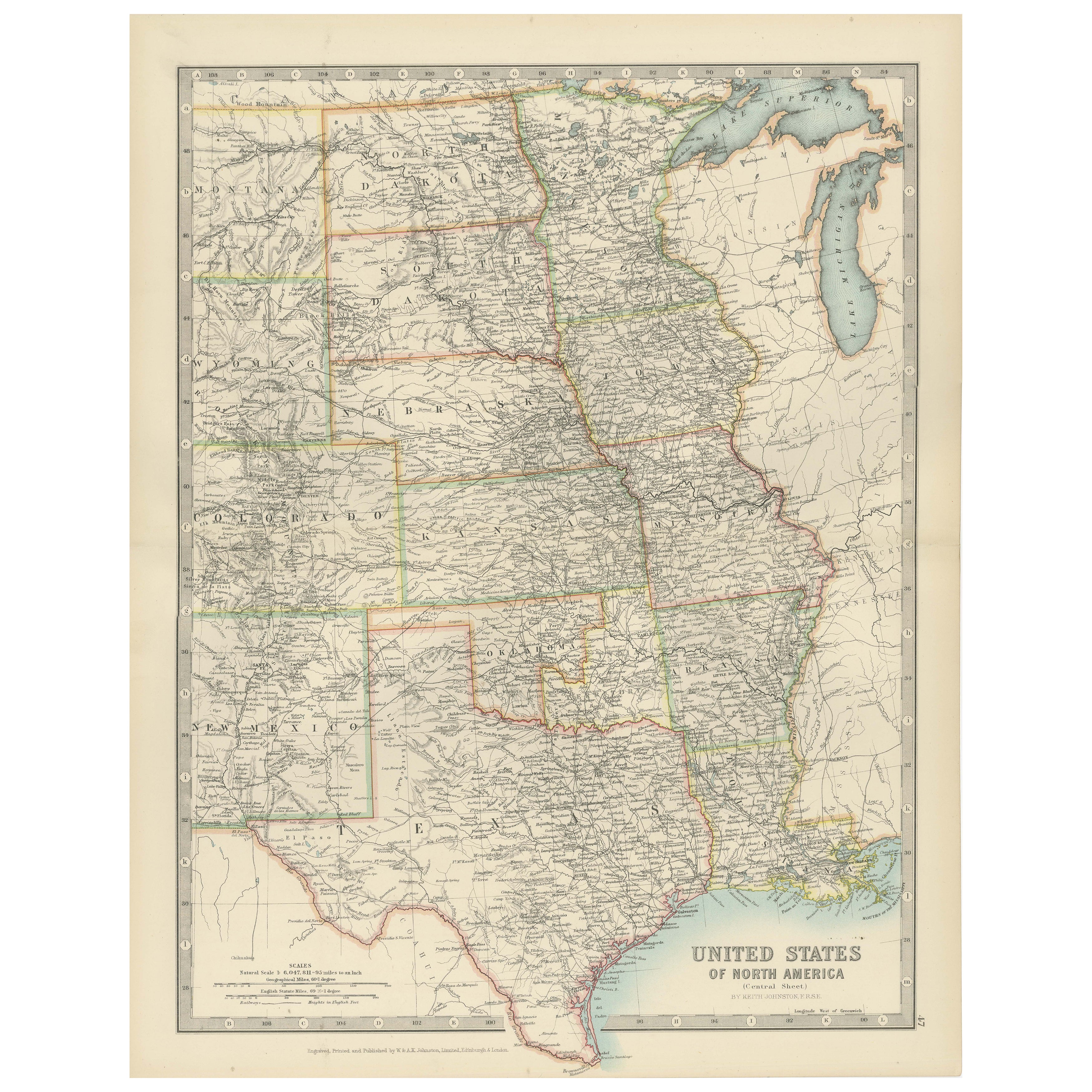
Map of United States Central Sheet 1903 – Railroads, States, and Topography
Located in Langweer, NL
Map of United States Central Sheet 1903 – Railroads, States, and Topography
This is a finely engraved and beautifully colored map titled "United States of North America (Central She...
Category
Early 20th Century English Maps
Materials
Paper
$325 Sale Price
20% Off
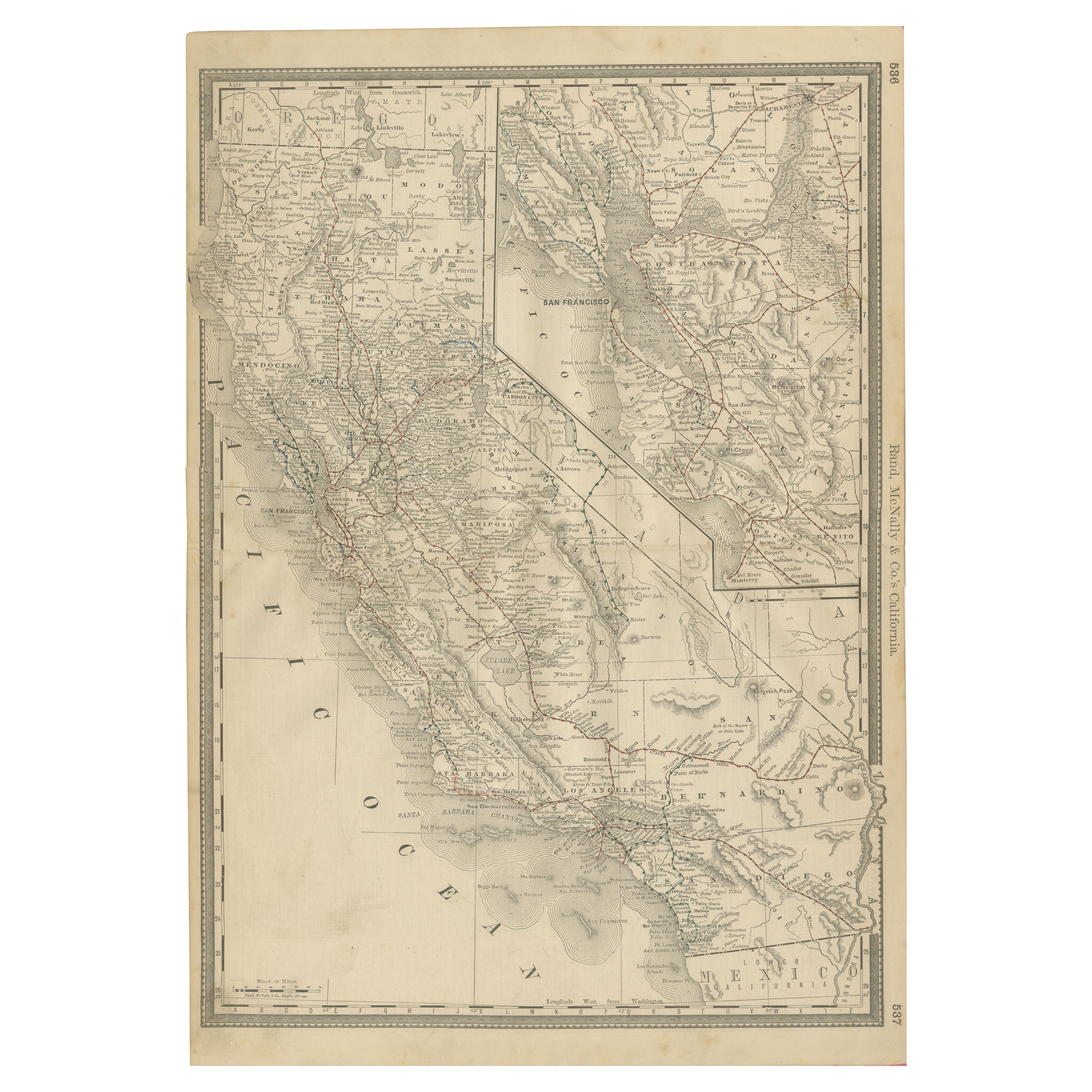
1888 California Map – The Golden State’s Railroads, Cities & Counties
Located in Langweer, NL
Antique Map of California – Railroads, Cities & Counties, 1888
This antique engraved map shows California in 1888, at a time of enormous growth and transformation. Published by Rand...
Category
Antique Late 19th Century American Maps
Materials
Paper
Antique Map of the United States 'North West' by Johnston, '1909'
Located in Langweer, NL
Antique map titled 'United States of North America'. Original antique map of the United States of North America ( North West ). This map originates from the ‘Royal Atlas of Modern Ge...
Category
Early 20th Century Maps
Materials
Paper

$239 Sale Price
20% Off
Antique Railroad Map of the United States by Rand, McNally & Co, 1900
Located in Langweer, NL
Antique map titled 'Rand, McNally & Co's New Official Railroad map of the United States with portions of The Dominion of Canada, The Republic of Mexico and the West Indies'. Large railroad map of the United States, sectionalised and laid on linen. Map shows state boundaries for the United States, Mexico, the West Indies, and lower portion of Canada; major cities and towns, military posts, Native American reservations, and railroads; Oklahoma and "Indian Territory." Inset: "Map of Alaska...
Category
20th Century Maps
Materials
Linen, Paper

$2,241 Sale Price
25% Off
Free Shipping
You May Also Like
Original Antique Map of the American State of California ( Northern Part ), 1903
Located in St Annes, Lancashire
Antique map of California ( Northern part )
Published By A & C Black. 1903
Original colour
Good condition
Unframed.
Free shipping
Category
Antique Early 1900s English Maps
Materials
Paper

Large Original Antique Map of California, USA, circa 1900
Located in St Annes, Lancashire
Fabulous map of California
Original color
Engraved and printed by the George F. Cram Company, Indianapolis.
Published, circa 1900
Unframed
Free shipping.
Category
Antique 1890s American Maps
Materials
Paper

California, Northern Part. USA Century Atlas state antique vintage map
Located in Melbourne, Victoria
'The Century Atlas. California, Northern Part'
Inset maps of 'Yosemite Valley' and 'San Francisco and Vicinity'.
Original antique map, 1903.
Central fold as issued. Map name and nu...
Category
Early 20th Century Victorian More Prints
Materials
Lithograph
Large Original Antique Map of the United States of America. 1891
By Rand McNally & Co.
Located in St Annes, Lancashire
Fabulous map of The United States
Original color
By Rand, McNally & Co.
Dated 1891
Unframed
Free shipping.
Category
Antique 1890s American Maps
Materials
Paper

Original Antique Map of the American State of California ( Southern Part ), 1903
Located in St Annes, Lancashire
Antique map of California ( Southern part )
Published By A & C Black. 1903
Original colour
Good condition
Unframed.
Free shipping
Category
Antique Early 1900s English Maps
Materials
Paper

1890 "Map of Oregon, Kansas, California, and the Territories" by S. A. Mitchell
By Samuel Augustus Mitchell 1
Located in Colorado Springs, CO
Presented is an 1890 map "Map of Oregon, Kansas, California, and the Territories" by S. A. Mitchell Jr. The map was issued in the atlas “Mitchell's New Intermediate Geography” publis...
Category
Antique 1890s American Victorian Maps
Materials
Paper

More Ways To Browse
Americana Antiques
Painted Bar Stools
3x5 Rugs
Tufted Bar
Green Oushak
Pelle Pelle Leather
Antique Marble Top Hall Table
Bent Plywood
Antique Column Base
Bureau Desk
Low Black Coffee Table
Porcelain Modern Hand Painted
Dining Tables With Brass Inlay
Louis Marble Top Side Table
Palace Size Carpet
Armchair In France
Blue Kilim Vintage
Contemporary Side Tables And Stools