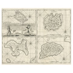
Items Similar to Mauritius, Banda Islands, Ternate and Tuban – Orlers, Leiden 1610


Video Loading
Want more images or videos?
Request additional images or videos from the seller
1 of 11
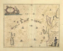
Mauritius, Banda Islands, Ternate and Tuban – Orlers, Leiden 1610
$406.94
£300.18
€340
CA$563.83
A$612.21
CHF 324.21
MX$7,503.93
NOK 4,012.22
SEK 3,791.33
DKK 2,588.37
About the Item
Title: Mauritius, Banda Islands, Ternate and Tuban – Orlers, Leiden 1610
Antique print from Jan Janszoon Orlers’ Den Nassauschen Lauren-Crans, published in Leiden in 1610 and engraved by H. van Haestens. The sheet contains four detailed early 17th century views connected to the Dutch voyages and conquests in the East Indies and Indian Ocean.
The top left view shows the island of Mauritius with Dutch colonists fishing and building boats. Of special importance is the depiction of the dodo bird together with giant tortoises, both unique to the island.
The top right view depicts the Banda Islands of Gunnanappi (Genung Api), Labetacq and Ortatan. Villages, nutmeg groves, a volcanic eruption and Dutch ships are shown. These islands were the centre of the lucrative nutmeg trade and a focus of conflict between the Dutch, English and Portuguese.
The bottom left view represents the city of Ternate, labelled Ciuitas Gammelamme. A royal procession led by the King of Ternate is seen, with the palace (Palatio) and a mosque (Mesquita) in the background, highlighting the political and religious structures of the Moluccas.
The bottom right view illustrates the Javanese city of Tuban, labelled Tubate. The King of Tuban rides in procession on an elephant, surrounded by courtiers and attendants. Numerous elephant enclosures and the royal court are also depicted.
This sheet combines ethnographic, geographic and natural historical information and is one of the earliest European engravings to show these regions. It is of special interest to collectors of Dutch colonial history, natural history, and VOC related prints.
Condition:
Fair to Good. General age-related toning, with light wear, typical for the period. Early hand colouring. Verso blank.
Framing tips:
Mount in ivory or cream to complement the aged paper. A dark wood or ebony frame brings out the historic atmosphere, while a gilt frame adds decorative impact. Double matting with a thin green or red line will echo the original colours.
Technique: Engraving with original hand colour
Maker: Jan Janszoon Orlers and H. van Haestens, Leiden, 1610
- Dimensions:Height: 9.57 in (24.3 cm)Width: 12.84 in (32.6 cm)Depth: 0.01 in (0.2 mm)
- Materials and Techniques:Paper,Engraved
- Place of Origin:
- Period:Early 17th Century
- Date of Manufacture:circa 1610
- Condition:Fair to Good. General age-related toning, with light wear, typical for the period. Early hand colouring. Verso blank.
- Seller Location:Langweer, NL
- Reference Number:Seller: BG-137801stDibs: LU3054346621592
About the Seller
5.0
Recognized Seller
These prestigious sellers are industry leaders and represent the highest echelon for item quality and design.
Platinum Seller
Premium sellers with a 4.7+ rating and 24-hour response times
Established in 2009
1stDibs seller since 2017
2,623 sales on 1stDibs
Typical response time: <1 hour
- ShippingRetrieving quote...Shipping from: Langweer, Netherlands
- Return Policy
Authenticity Guarantee
In the unlikely event there’s an issue with an item’s authenticity, contact us within 1 year for a full refund. DetailsMoney-Back Guarantee
If your item is not as described, is damaged in transit, or does not arrive, contact us within 7 days for a full refund. Details24-Hour Cancellation
You have a 24-hour grace period in which to reconsider your purchase, with no questions asked.Vetted Professional Sellers
Our world-class sellers must adhere to strict standards for service and quality, maintaining the integrity of our listings.Price-Match Guarantee
If you find that a seller listed the same item for a lower price elsewhere, we’ll match it.Trusted Global Delivery
Our best-in-class carrier network provides specialized shipping options worldwide, including custom delivery.More From This Seller
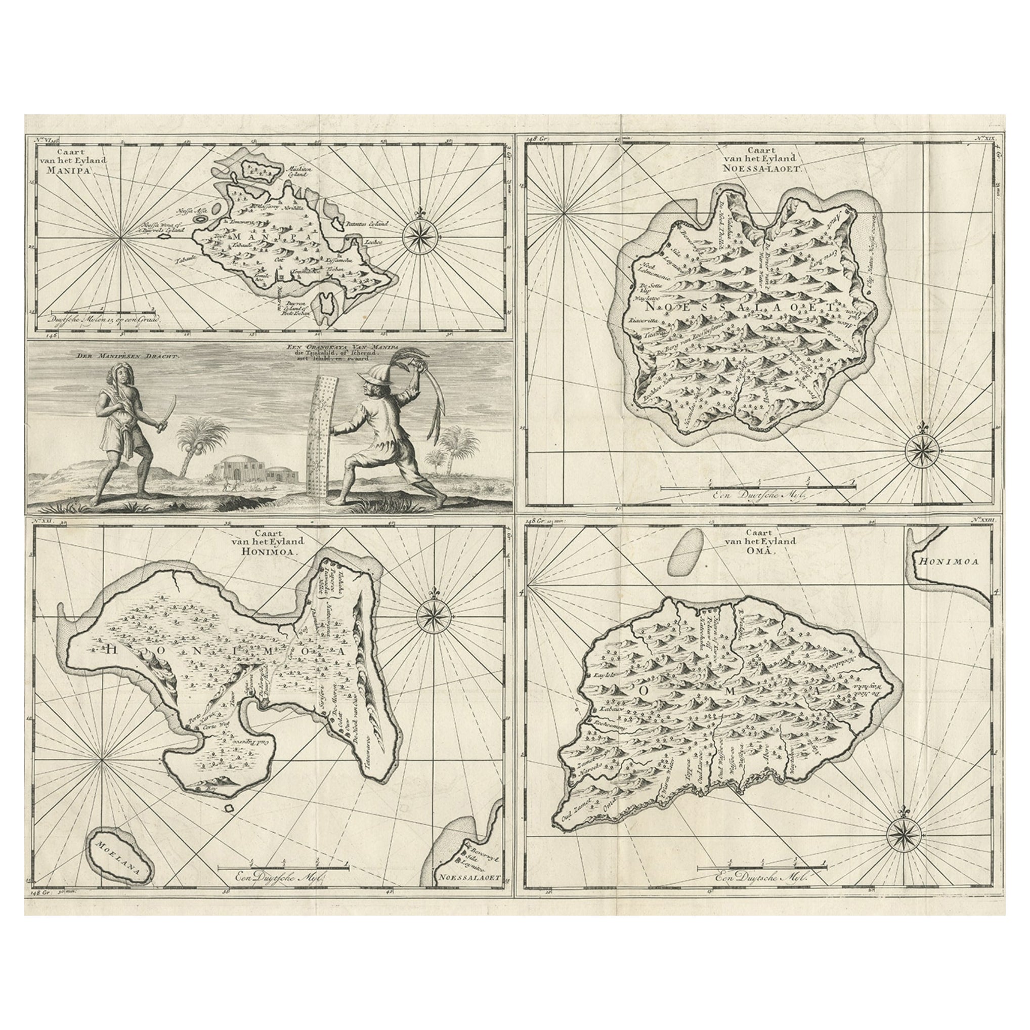
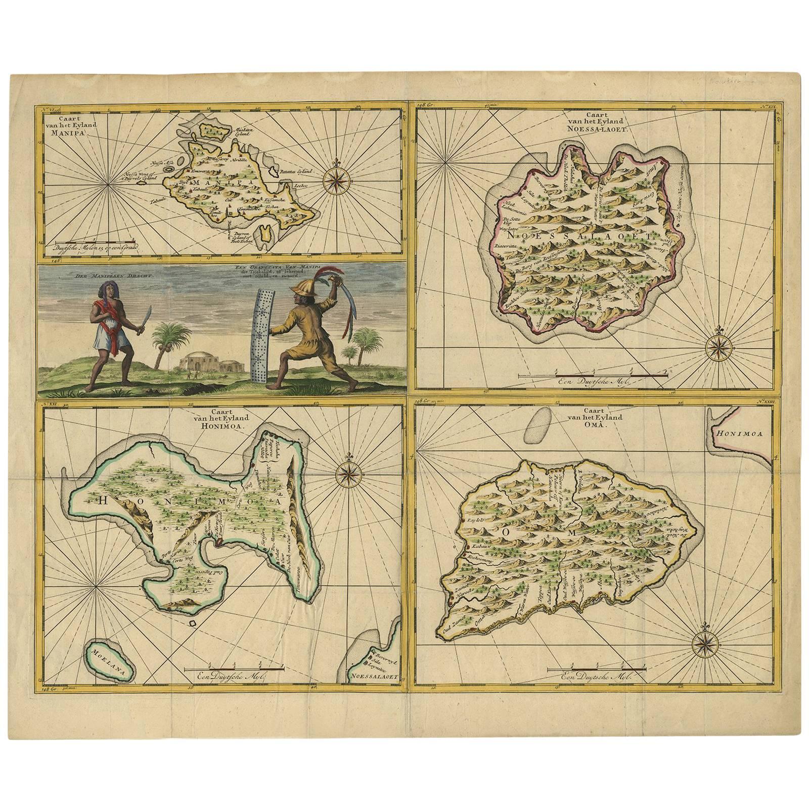
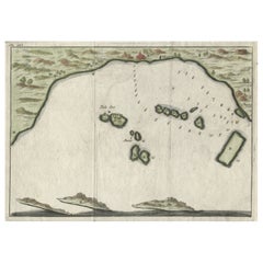
View AllAntique Maps of Manipa, Nusa-Laut, Saparua and Haruku in Maluku, Indonesia 1726
Located in Langweer, NL
Antique map titled 'Caart van het Eyland Manipa, Noessa-Laoet, Honimoa, Oma. Der Manipesen dracht, een Orangkaya van Manipa.' Four maps of islands and two figures in native dress. Th...
Category
Antique 18th Century Maps
Materials
Paper
$335 Sale Price
20% Off
Antique Map of Manipa, Nusa-Laut, Saparua & Haruku 'Indonesia' by F. Valentijn
Located in Langweer, NL
Four maps of islands and two figures in native dress. The islands are: Manipa, Nusa-Laut (Noessa-Laoet), Saparua (Honimoa) and Haruku (Oma). These islands...
Category
Antique Early 18th Century Maps
Materials
Paper

$813 Sale Price
20% Off
Small Early 18th Century Map of Banten Bay on the Island Java, Indonesia, c.1725
Located in Langweer, NL
A small early 18th century map of Banten Bay showing the islands of Pulo Dua and Pulo Batto together with soundings within the Bay and profiles of hills on the islands published by C...
Category
Antique 1720s Maps
Materials
Paper
$210 Sale Price
20% Off
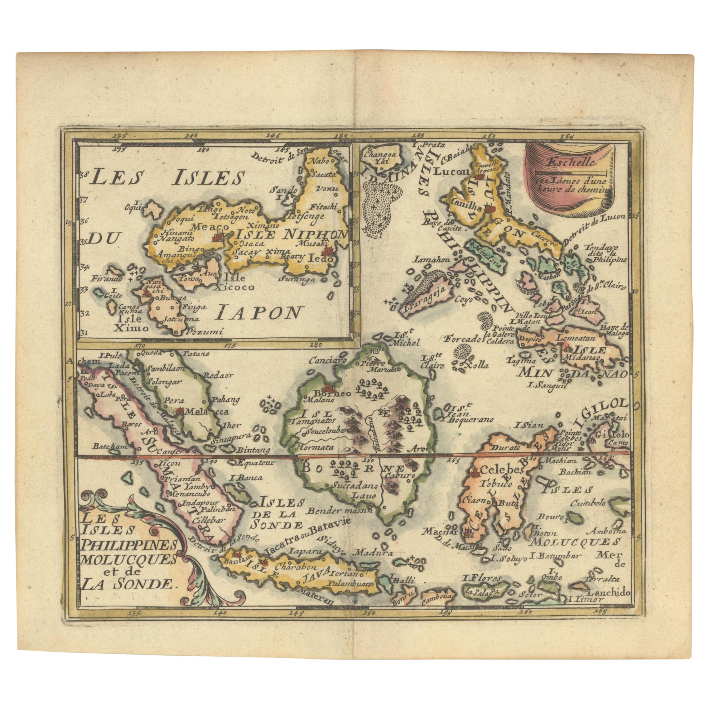
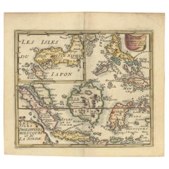
1692 Jacq. Peeters Map: East Indies, Indonesia, Japan, Philippines and Singapore
Located in Langweer, NL
1692 Jacques Peeters Map: East Indies, Indonesia & Japan with Unique Inset
This hand-colored map from 1692, created by Jacques Peeters, captures the islands of Indonesia, the Philippines, and features a unique inset of Japan.
It closely resembles Nicolas de Fer's map and is primarily based on Sanson's influential maps. The map meticulously details cities, smaller settlements, rivers, mountain chains, and forests, offering a comprehensive view of the region's geography.
The inset map of Japan stands out due to its distinctive shape and influences, reflecting different cartographic sources. Notable features include the marked equator and detailed latitude and longitude indications on the borders.
The map measures 6.5 inches in width by 5.5 inches in height and is in excellent condition, with a dark impression, slight toning, and a minor centerfold crease.
Keywords:
- East Indies map
- Indonesia historical map
- Philippines map...
Category
Antique 1690s Maps
Materials
Paper
$631 Sale Price
20% Off
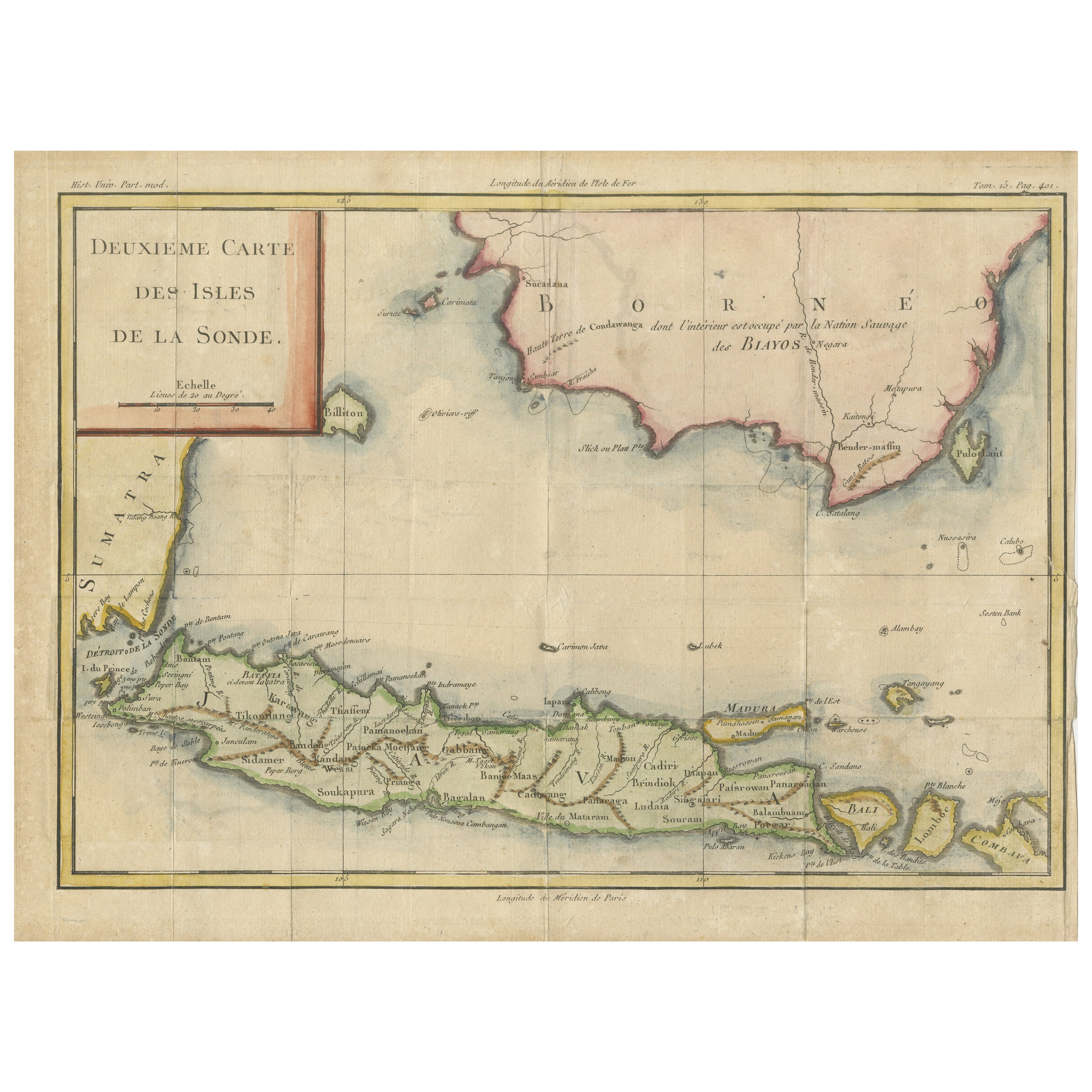
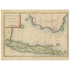
Java and Bali with Borneo Coast – 18th Century French Colonial Map
Located in Langweer, NL
Java and Bali with Borneo Coast – 18th Century French Colonial Map
This original copperplate engraved map titled "Deuxième Carte des Isles de la Sonde" offers a rare and valuable 18...
Category
Antique Mid-18th Century French Maps
Materials
Paper
Antique Map of the Island Java, Indonesia, c.1650
Located in Langweer, NL
Antique map titled 'Insulae Iavae cum parte insularum Boreno Sumatrae (..)'.
Beautiful map of the island of Java and part of Borneo, Bali, Madura and Sumatra. With decorative carto...
Category
Antique 17th Century Maps
Materials
Paper

$3,111 Sale Price
20% Off
You May Also Like
S.Juan de Puerto Rico - Etching by Johannes Janssonius - 1650s
By Johannes Janssonius
Located in Roma, IT
S.Juan de Puerto Rico is an ancient map realized in 1650 by Johannes Janssonius (1588-1664).
Good conditions.
From Atlantis majoris quinta pars, Orbem maritimum [Novus Atlas, volum...
Category
1650s Modern Figurative Prints
Materials
Etching
Antique Voc Print Holland Malaysia Old Map Melaka History, 1663
Located in Amsterdam, Noord Holland
From my own collection I offer this impressive Antique print of the city of Malakka
A very interesting piece for collectors . It is an museum piece from the Dutch Institute of Orien...
Category
Antique 17th Century European Paintings
Materials
Paper

$293 Sale Price
20% Off
Ancient Map - Zeilan - Etching by Johannes Janssonius - 1650s
By Johannes Janssonius
Located in Roma, IT
Ancient Map - Zeilan is an ancient map realized in 1650 by Johannes Janssonius (1588-1664).
The Map is Hand-colored etching, with coeval watercoloring.
...
Category
1650s Modern Figurative Prints
Materials
Etching

Mexico City by Braun & Hogenberg c. 1590
By Georg Braun and Frans Hogenberg
Located in Stamford, CT
Mexico by Braun & Hogenberg c. 1590
Category
Antique Mid-19th Century European Spanish Colonial Maps
Materials
Glass, Wood, Paper
1633 Map "La Souverainete De Sedan Et De Raucourt, Et La Prevoste Ric0011
Located in Norton, MA
1653 map entitled
"La Souverainete de Sedan et de Raucourt, et la Prevoste de Doncheri,"
Ric0011
Description:
Lovely map centered on Sedan and Doncheri and the Meuze River fr...
Category
Antique 17th Century Dutch Maps
Materials
Paper

Rugen Island, Germany: An Early 17th Century Map by Mercator and Hondius
By Gerard Mercator
Located in Alamo, CA
This is an early 17th century map entitled "Nova Famigerabilis Insulae Ac Ducatus Rugiae Desciptio" (Map of Rugen Island, Germany) by Gerard Mercator and Henricus and Joducus Hondiu...
Category
Early 17th Century Old Masters Landscape Prints
Materials
Engraving
