Items Similar to Old Map of the American Railroad Network and All Weather Roads on Verso, 1931
Want more images or videos?
Request additional images or videos from the seller
1 of 6
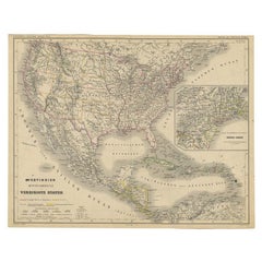
Old Map of the American Railroad Network and All Weather Roads on Verso, 1931
About the Item
This is the “New Census Edition” of Clason’s United States Green Guide. It features two large maps of the United States on a single sheet.
The recto map shows the complete road network in the country with a legend identifying paved roads, all weather roads, and other thoroughfares. The verso shows states outlined in green with the dense railroad network delineated and individual railroads named. The map sheet is laid into the 32-page guidebook, which includes information on National Monuments, a table of distances, list of states and cities, and more.
The pictorial covers feature an Indian maiden and priced at 35 cents (4.0 x 6.5”). This was the last year that the “green guide” was published as the Clason Company fell victim to the Great Depression in 1932.
- Dimensions:Height: 20.71 in (52.6 cm)Width: 32.8 in (83.3 cm)Depth: 0 in (0.01 mm)
- Materials and Techniques:
- Period:
- Date of Manufacture:1931
- Condition:Incredibly clean and bright with a small abrasion in the top right corner of the road map where it was adhered to the guide. Issued folding. Light wear to covers.
- Seller Location:Langweer, NL
- Reference Number:1stDibs: LU3054335366082
About the Seller
5.0
Platinum Seller
These expertly vetted sellers are 1stDibs' most experienced sellers and are rated highest by our customers.
Established in 2009
1stDibs seller since 2017
1,916 sales on 1stDibs
Typical response time: <1 hour
- ShippingRetrieving quote...Ships From: Langweer, Netherlands
- Return PolicyA return for this item may be initiated within 14 days of delivery.
More From This SellerView All
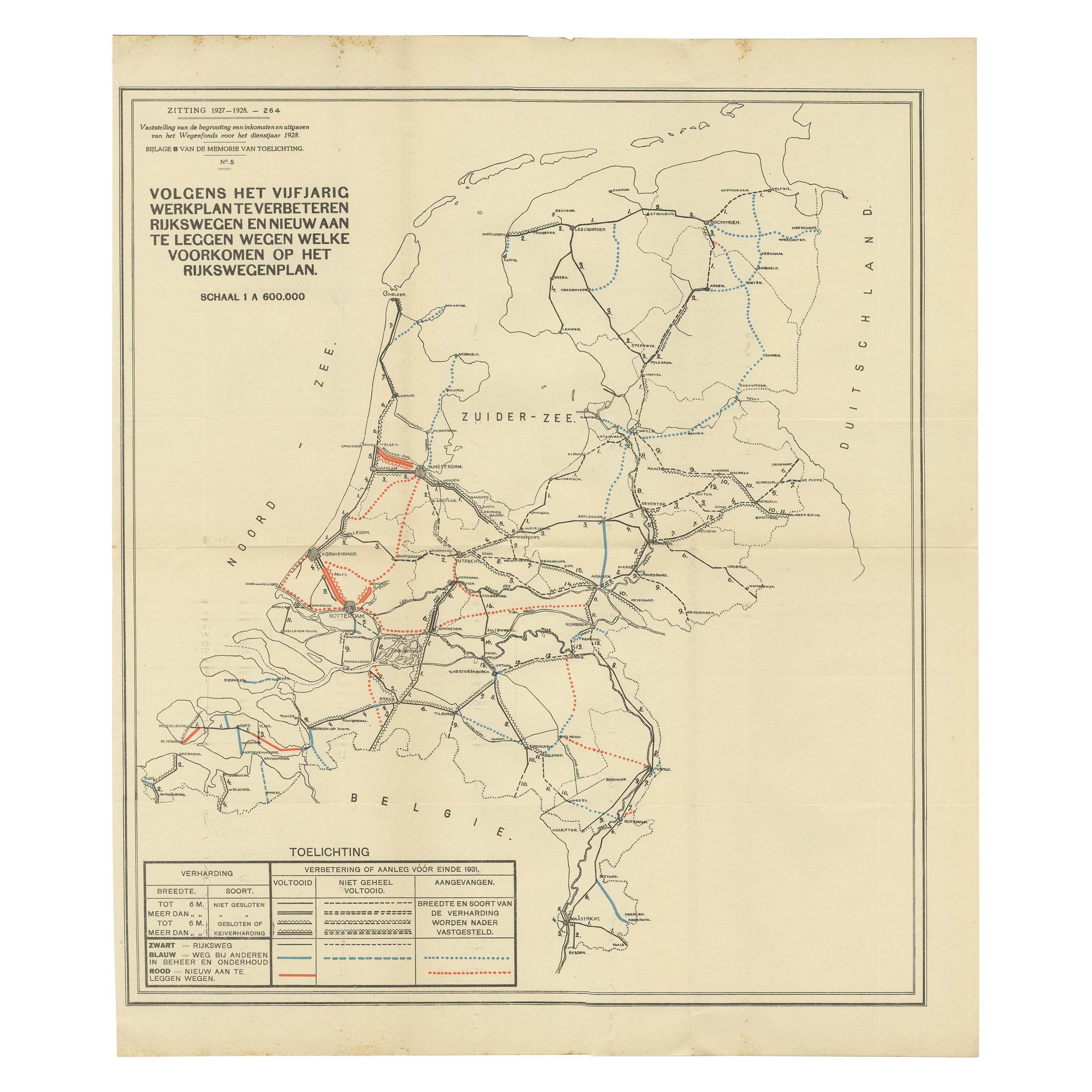
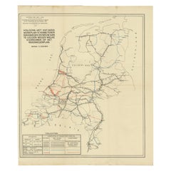
- Vintage Road Map of the Netherlands '1928'Located in Langweer, NLVintage map titled 'Volgens het vijfjarig Werkplan te verbeteren Rijkswegen en nieuw aan te leggen wegen welke voorkomen op het Rijkswegenplan'. Map of the Netherlands...Category
20th Century Maps
MaterialsPaper
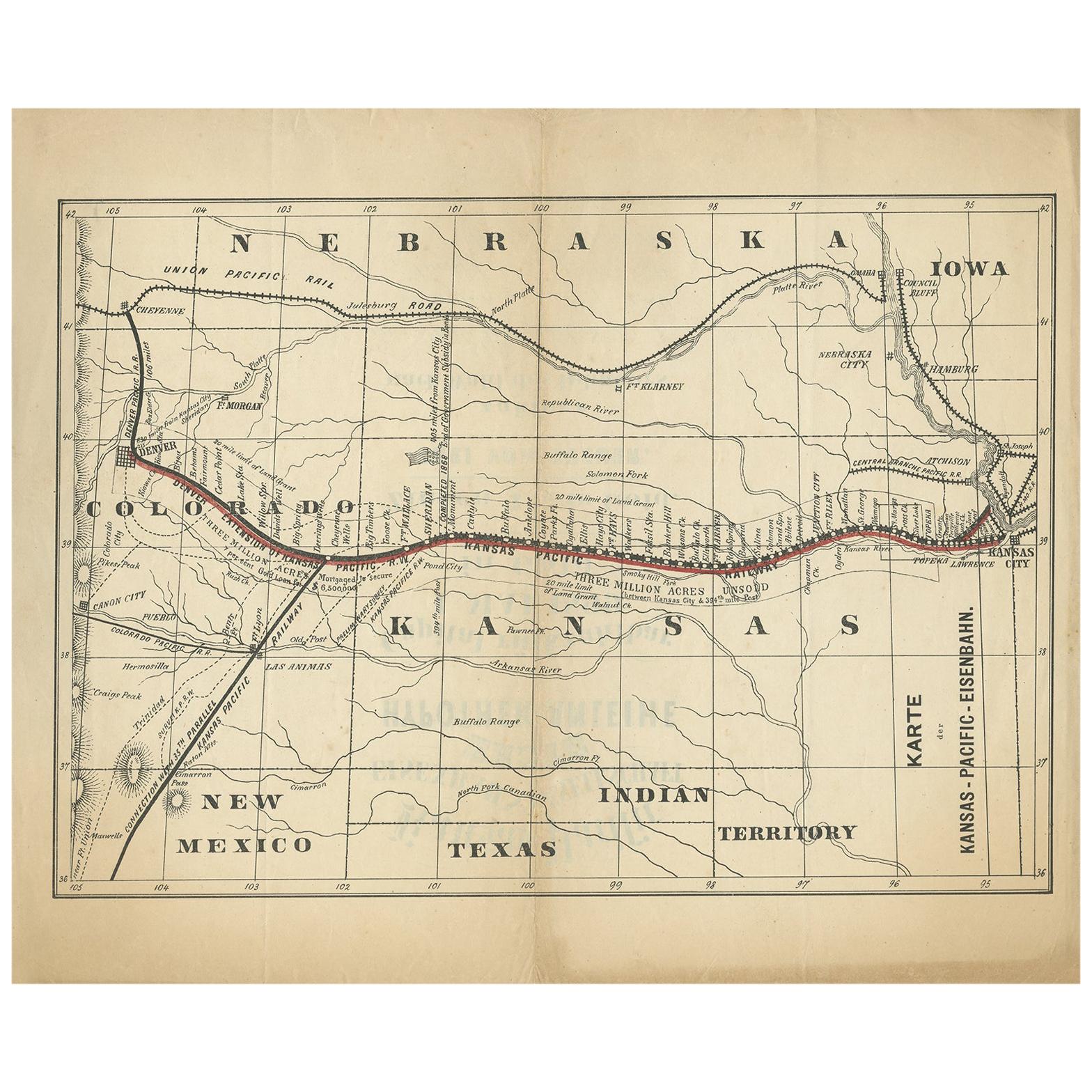
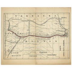
- Antique Map of the Kansas Pacific Railroad, circa 1900Located in Langweer, NLAntique map titled 'Karte der Kansas-Pacific-Eisenbahn'. Lithographed map of the Kansas Pacific railroad. German text on verso which reads 'Kansas Pacific Eisenbahn Gesellschaft erst...Category
Early 20th Century Maps
MaterialsPaper
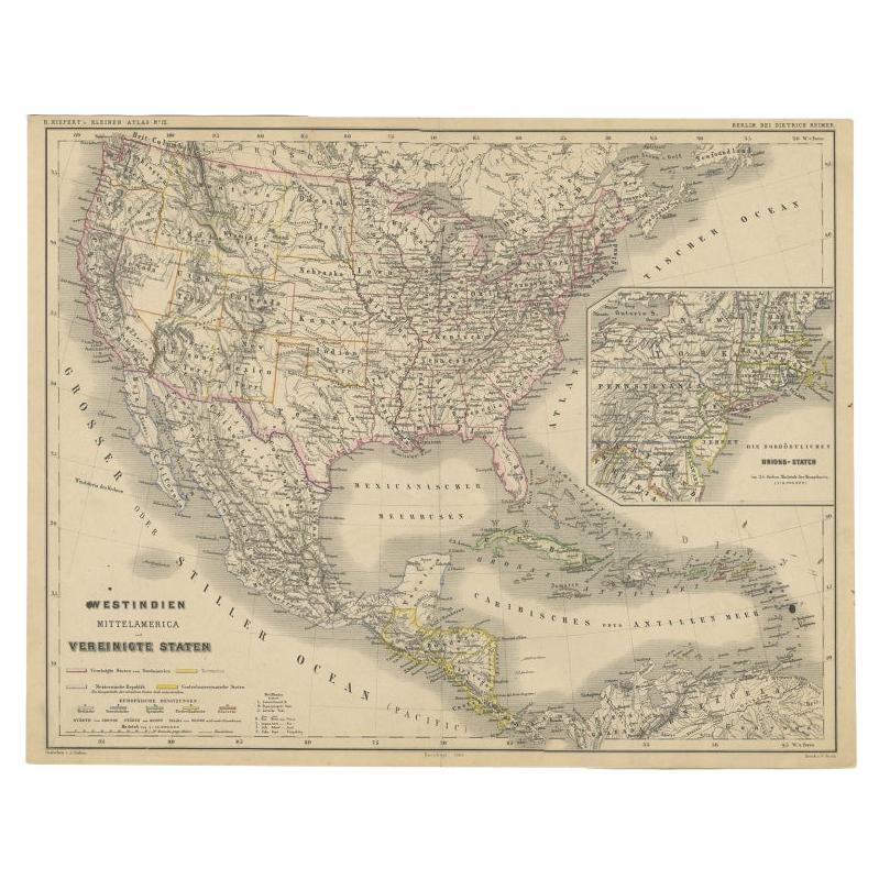
- Old German Map of the United States, Central America and the West Indies, c.1870Located in Langweer, NLAntique map titled 'Westindien, Mittelamerica und Vereinigte Staten'. Old map of the United States, Central America and the West Indies. This map originates from 'H. Kiepert's Kleine...Category
Antique 19th Century Maps
MaterialsPaper
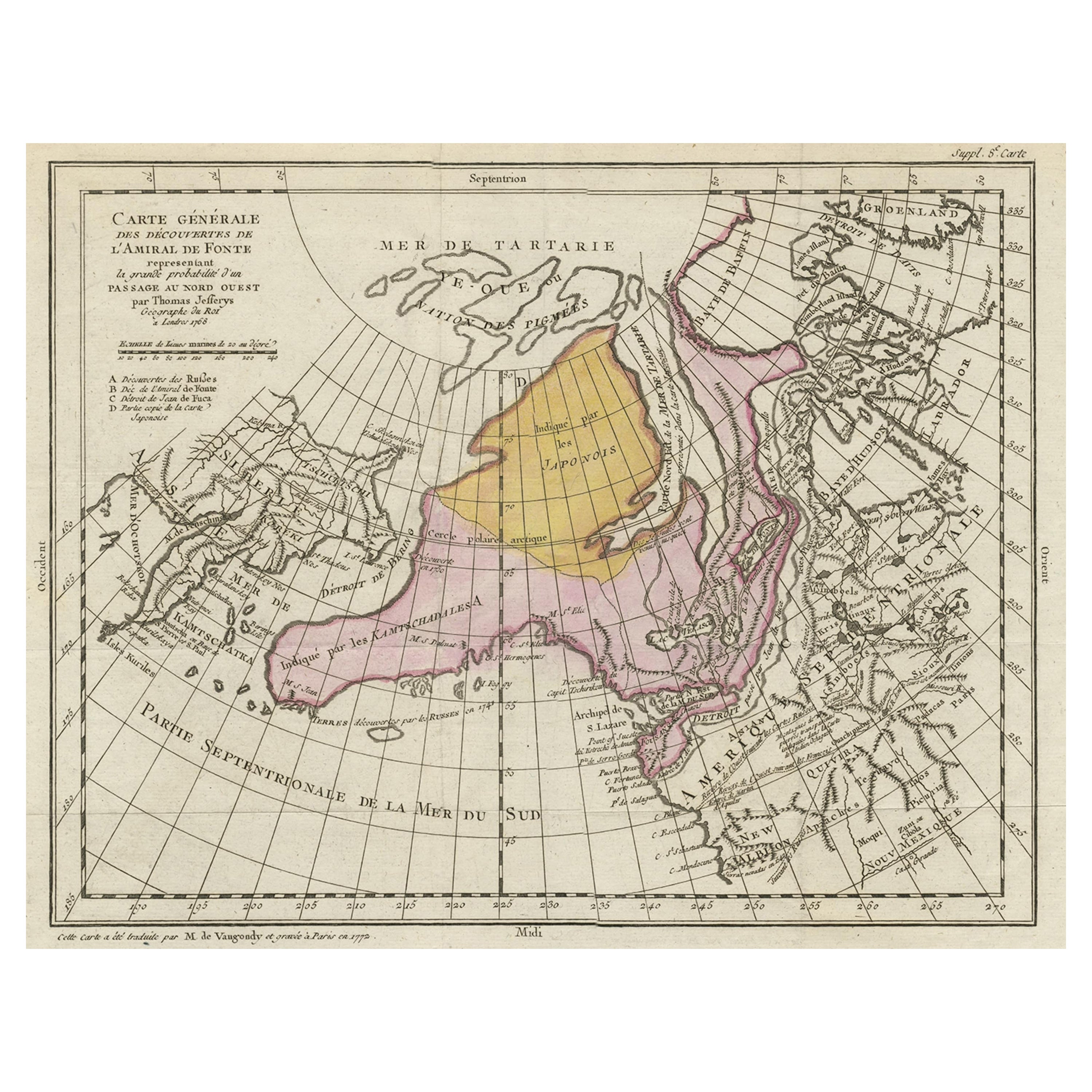
- Interesting Old Map of the Nw Coast of America and the Ne Coast of Asia, ca.1772Located in Langweer, NLAntique map titled 'Carte Generale des Decouvertes de l'Amiral de Fonte (..)'. Original antique map of the discoveries of Admiral de Fonte, showing the possibility of a north-west passage. Interesting map of the NW Coast...Category
Antique 1770s Maps
MaterialsPaper
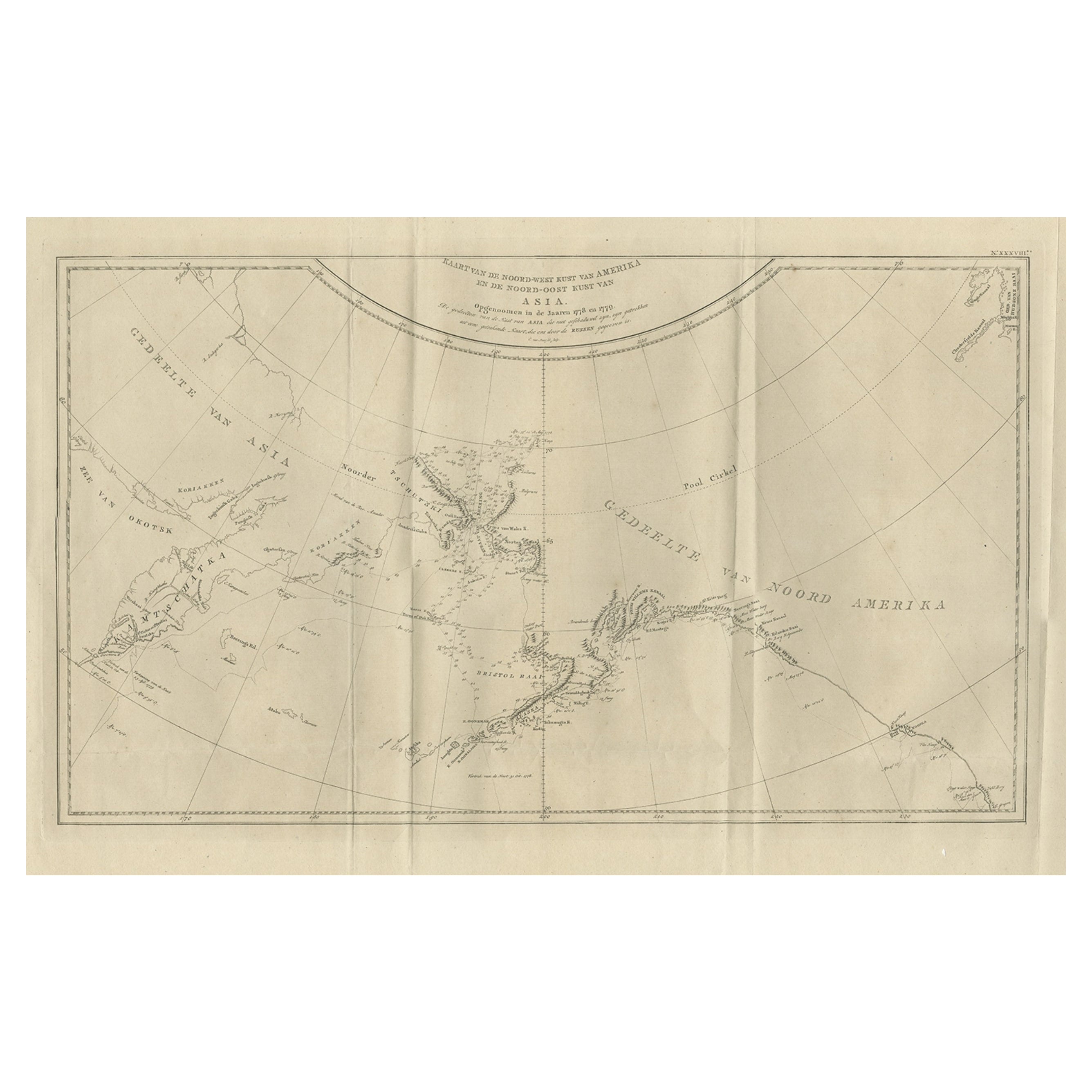
- Old Map Showing the Tracks of Cook Between North America and Asia's Coast, 1803Located in Langweer, NLDescription: Antique map titled 'Kaart van de Noord-West kust van Amerika en de Noord-Oost kust van Asia'. Antique chart depicting America's northwest coast and Asia's northeast ...Category
Antique Early 1800s Maps
MaterialsPaper
- Old Map of the Great Lakes and Upper Mississippi Valley, Northern America, c1780Located in Langweer, NLAntique map titled 'Partie Occidentale du Canada'. A fine example of Rigobert Bonne and Guilleme Raynal's 1780 map of the Great Lakes and upper Mississippi Valley. A map of c...Category
Antique 1780s Maps
MaterialsPaper

You May Also Like
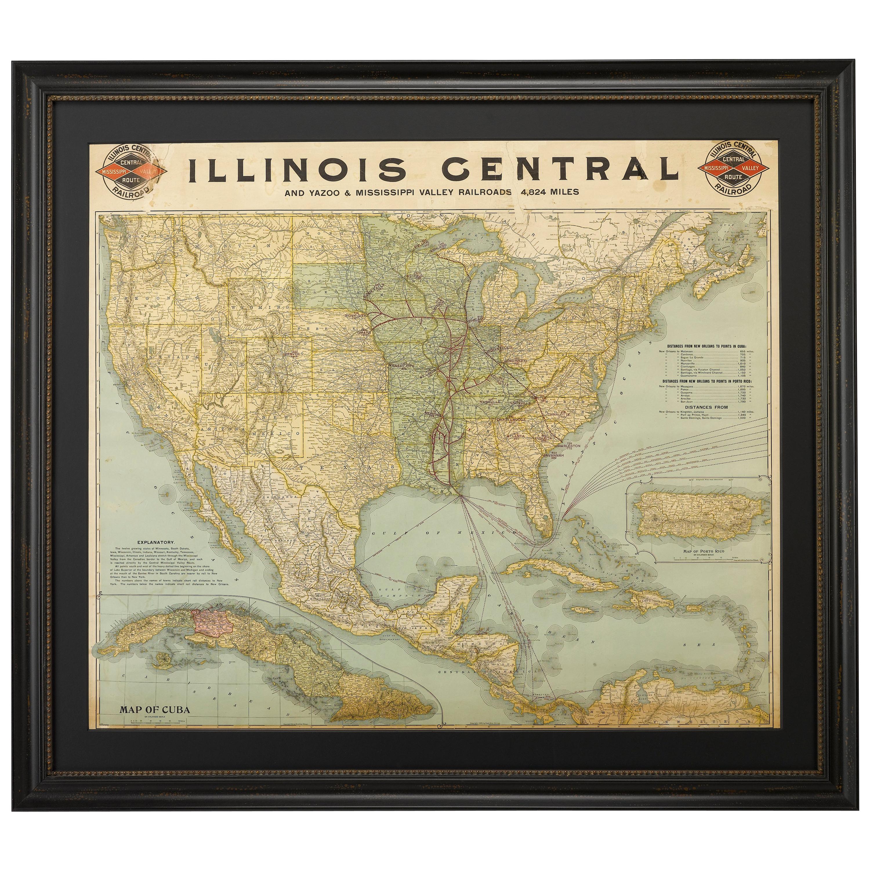
- 1899 Poole Brothers Antique Railroad Map of the Illinois Central RailroadLocated in Colorado Springs, COThis is an 1899 railroad map of the Illinois Central and Yazoo and Mississippi Valley Railroads, published by the Poole Brothers. The map focuses on the continuous United States from the Atlantic to the Pacific Oceans, the Gulf of Mexico, and the Antilles. Remarkably detailed, the rail routes of the Illinois Central RR are marked in red, which each stop labeled. Major stops are overprinted in red, bold letters, with the short rail distances to New York listed above the stop and short rail distances to New Orleans listed below the name. In addition to the Illinois Central network, numerous different rail lines are illustrated and the company running that line is noted along with many stops along each route. Sea routes from New Orleans to locations in Central America, the Caribbean, and Europe are marked and labeled with destination and distance, along with routes originating from Havana. Inset at bottom left is a map of Cuba; an inset map of Puerto Rico...Category
Antique 1890s American Maps
MaterialsPaper
- 1866 Ensign & Bridgman's Rail Road Map of the United StatesLocated in Colorado Springs, COPresented is an 1866 issue of “Ensign & Bridgeman’s Rail Road Map of the United States, showing Depots & Stations.” First published in 1856, this is the third edition, following anot...Category
Antique 1860s American Late Victorian Maps
MaterialsPaper
- 1931 The Iliad and The OdysseyBy Alexander Pope, HomerLocated in Bath, GBA fine, limited edition set of Pope's translation of the Iliad and the Odyssey with excellent provenance. Limited edition, With Homer numbered 1051 and The Iliad numbered 1196. With text in both Latin and Greek. The Nonesuch Press specialised in limited edition and private press. They were founded by Francis Meynell, his second wife Vera Mendel and their friend David Garnett. Their aspiration was for their publications to be aligned with the same aesthetic standards as the private press movement. They were unusual as they used a small Albion press...Category
Vintage 1930s British Books
MaterialsPaper
- Old Nautical Map of CorsicaLocated in Alessandria, PiemonteST/556/1 - Old map of Corsica isle, surveyed by Captain Hell, of the French Royal Navy in 1824, engraved and published on 1874, with additions and corre...Category
Antique Early 19th Century English Other Prints
MaterialsPaper
- Old Horizontal Map of EnglandBy TassoLocated in Alessandria, PiemonteST/520 - Old rare Italian map of England, dated 1826-1827 - by Girolamo Tasso, editor in Venise, for the atlas of M.r Le-Sage.Category
Antique Early 19th Century Italian Other Prints
MaterialsPaper
- 1859 "Map of the United States of America..." by J. H. ColtonBy J.H. ColtonLocated in Colorado Springs, COPresented is an 1859 “Map of the United States of America, the British Provinces, Mexico, the West Indies and Central America with Part of...Category
Antique 1850s American Maps
MaterialsPaper


Recently Viewed
View AllMore Ways To Browse
Paris Antique Map
Vintage Map World
Vintage Maps World
Map Of Indonesia
Antique Map Coats Of Arms
Antique Book Map France
Cornelius And Company
Munster Map
Nova Scotia Map
Map Of Utah
Royal Picardie
Vintage Maps Of Hawaii
Vintage Road Maps Collectables
United States Antique Map
Office Depot
Old Maps England
Map Sumatra
Scotland Coat Of Arms