Items Similar to Old Map of British Mediterranean Territories with Images of Historic Sites, 1851


Want more images or videos?
Request additional images or videos from the seller
1 of 6
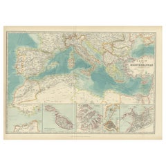
Old Map of British Mediterranean Territories with Images of Historic Sites, 1851
$342.86
$428.5720% Off
£254.84
£318.5520% Off
€288
€36020% Off
CA$473.39
CA$591.7420% Off
A$524.96
A$656.2020% Off
CHF 275.83
CHF 344.7820% Off
MX$6,414.10
MX$8,017.6320% Off
NOK 3,450.97
NOK 4,313.7120% Off
SEK 3,239.32
SEK 4,049.1620% Off
DKK 2,192.98
DKK 2,741.2220% Off
About the Item
John Tallis & Company was a British map-making firm that gained widespread acclaim in the 19th century, particularly known for their detailed and artistically embellished maps. The firm was renowned for including elaborate margins and vignettes that depicted various aspects of the region in question, such as local scenes, people, fauna, and flora.
The map of the British Possessions in the Mediterranean is likely one in a series created for "The British Colonies" by Robert Montgomery Martin. These maps typically showed not just the geography, but also highlighted the extent and reach of the British Empire at the time. They were as much political statements as they were geographical tools, showcasing Britain's global dominance.
This particular map would have detailed the various British-controlled territories in the Mediterranean region. This would include major strategic holdings such as Gibraltar and Malta, among others. The detailed insets and vignettes would depict important landmarks, like the Rock of Gibraltar or the Grand Harbor of Valletta, and perhaps key battles or events, reflecting their historical and strategic importance to British imperial interests.
The countries and regions depicted in this map were crucial naval bases and points of control that allowed the British Empire to exert influence over the Mediterranean Sea, protecting trade routes and maintaining military strength.
The Tallis series of maps are significant historical documents. They serve as a testament to the period's cartographic techniques, as well as the political aspirations and cultural attitudes of the British Empire. Today, these maps are valued for their artistic qualities and as historical records of British imperialism.
The images in more detail:
The images or insets on this map are detailed engravings that depict significant locations within the British possessions in the Mediterranean. Here's a description:
1. **Corfu**: This inset likely shows a view of Corfu, a Greek island in the Ionian Sea. It may depict the coastal landscape along with the architecture and fortifications that were significant during the British administration.
2. **Vathi, Ithaca**: Vathi is the main harbor of Ithaca, an island famously associated with Homer's "Odyssey." The scene might capture the tranquil waterfront and local boats, reflecting the peaceful Mediterranean lifestyle.
3. **Valletta**: This would be an illustration of Valletta, the capital of Malta, highlighting its historic skyline. The fortified city is known for its strategic importance and the Grand Harbour, which could be featured in the engraving.
4. **Gibraltar**: The image here probably presents a view of the Rock of Gibraltar, an overseas territory of the UK. It might show important landmarks like the neutral ground, the bay, and perhaps the Moorish Castle or the Great Siege Tunnels, essential to Gibraltar's military history.
These insets not only add artistic value to the map but also serve as informative windows into the local geographies and histories of these strategic Mediterranean holdings under British control during the 19th century.
- Dimensions:Height: 14.26 in (36.2 cm)Width: 10.71 in (27.2 cm)Depth: 0 in (0.02 mm)
- Materials and Techniques:
- Period:
- Date of Manufacture:1851
- Condition:Good given age. Original fold in middle as published. General age-related toning, please study scan carefully.
- Seller Location:Langweer, NL
- Reference Number:Seller: BG-13736-91stDibs: LU3054339296632
About the Seller
5.0
Recognized Seller
These prestigious sellers are industry leaders and represent the highest echelon for item quality and design.
Platinum Seller
Premium sellers with a 4.7+ rating and 24-hour response times
Established in 2009
1stDibs seller since 2017
2,609 sales on 1stDibs
Typical response time: <1 hour
- ShippingRetrieving quote...Shipping from: Langweer, Netherlands
- Return Policy
Authenticity Guarantee
In the unlikely event there’s an issue with an item’s authenticity, contact us within 1 year for a full refund. DetailsMoney-Back Guarantee
If your item is not as described, is damaged in transit, or does not arrive, contact us within 7 days for a full refund. Details24-Hour Cancellation
You have a 24-hour grace period in which to reconsider your purchase, with no questions asked.Vetted Professional Sellers
Our world-class sellers must adhere to strict standards for service and quality, maintaining the integrity of our listings.Price-Match Guarantee
If you find that a seller listed the same item for a lower price elsewhere, we’ll match it.Trusted Global Delivery
Our best-in-class carrier network provides specialized shipping options worldwide, including custom delivery.More From This Seller
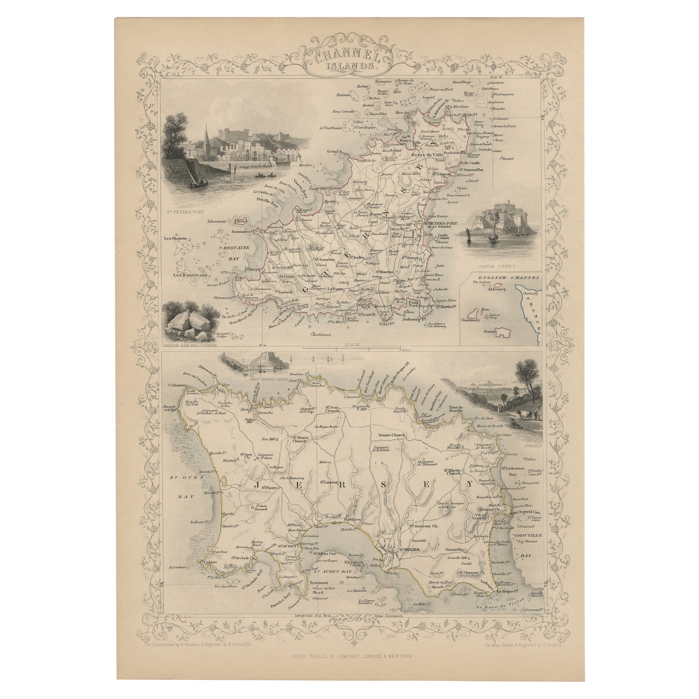
View AllOriginal Antique Map of the Channel Islands, Incl. Decorative Vignettes, 1851
Located in Langweer, NL
Antique map titled ‘Channel Islands’.
Includes decorative vignettes titled St. Peters Port, Castle Cornet, Druidical altar near Lancresse, Mont Orgueil Castle and Jersey. Originates from 'The Illustrated Atlas, And Modern History Of The World Geographical, Political, Commercial & Statistical, Edited By R. Montgomery Martin'. Published; John Tallis London, New York, Edinburgh & Dublin. 1851. Drawn and Engraved by J. Rapkin.
Artists and engravers: John Tallis (1817-1876) was a British map...
Category
Antique 1850s Maps
Materials
Paper
$428 Sale Price
20% Off
Antique Map of Southern Italy by J. Tallis, circa 1851
Located in Langweer, NL
Decorative and detailed mid-19th century map of Southern Italy which was drawn and engraved by John Rapkin (vignettes by A. H. Wray and J. Rogers...
Category
Antique Mid-19th Century Maps
Materials
Paper

$261 Sale Price
20% Off
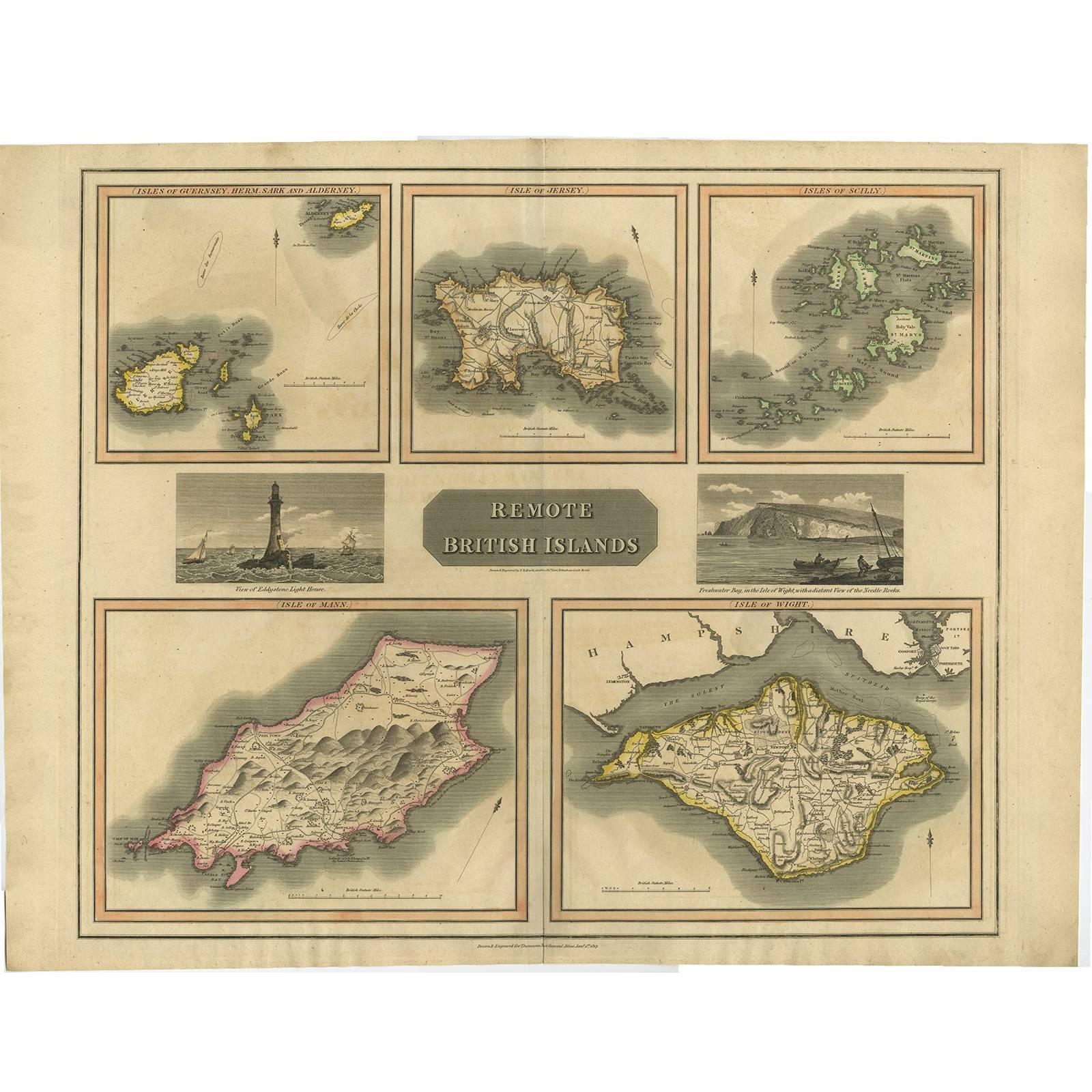
Antique Map of the British Islands by J. Thomson, 1817
Located in Langweer, NL
Group of 5 maps of the Channel Islands, Scilly, Jersey, the Isle of Mann and the Isle of Wight. Engraved views of the Eddystone Lighthouse and Freshwater Bay on the Isle of Wight, wi...
Category
Antique Early 19th Century Maps
Materials
Paper
Antique Map of the Islands of the Atlantic by J. Tallis
Located in Langweer, NL
A highly decorative and detailed mid-19th century map of the Islands of the Atlantic -- including the Azores, Madeira, Bermuda, the Canary Islands and the Cape Verde Islands -- which...
Category
Antique Mid-19th Century Maps
Materials
Paper

$285 Sale Price
20% Off
Antique Map of Algeria and the French Colonies, 1875
Located in Langweer, NL
Antique map titled 'Algérie et Colonies Francaises'. Large map of Algeria and the French Colonies. This map originates from 'Atlas de Géographie Moderne Physique et Politique' by A. ...
Category
Antique Late 19th Century French Maps
Materials
Paper

$309 Sale Price
35% Off
Antique Map of the Basin of the Mediterranean by Johnston '1909'
Located in Langweer, NL
Antique map titled 'Basin of the Mediterranean'. Original antique map of the basin of the Mediterranean. With inset maps of the Strait of Gibraltar, Morocco, Maltese Islands, Valetta...
Category
Early 20th Century Maps
Materials
Paper
$285 Sale Price
20% Off
You May Also Like
Large Original Antique Map of The Greek Islands. 1894
Located in St Annes, Lancashire
Superb Antique map of The Greek Islands
Published Edward Stanford, Charing Cross, London 1894
Original colour
Good condition
Unframed.
Free shipping
Category
Antique 1890s English Maps
Materials
Paper

Large Original Antique Map of South Italy and Malta by Sidney Hall, 1847
Located in St Annes, Lancashire
Great map of South Italy and Malta
Drawn by Sidney Hall
Steel engraving by G.Aikman
Original color outline
Published by A & C Black. 1847
Un...
Category
Antique 1840s Scottish Maps
Materials
Paper

Large Original Antique Map of Cyprus. 1894
Located in St Annes, Lancashire
Superb Antique map of Cyprus
Published Edward Stanford, Charing Cross, London 1894
Original colour
Good condition
Unframed.
Free shipping
Category
Antique 1890s English Maps
Materials
Paper

1851 Map of "Independent Tartary", Ric. R018
Located in Norton, MA
1851 Map of
Independent Tartary
"Russia"
Ric.r018
A highly decorative 1851 map of Independent Tartary by John Tallis and John Rapkin. Covers the regions between the Caspian Sea and Lake Bakquash and between Russia and Afghanistan. These include the ancient Silk Route kingdoms of Khiva, Tartaria, Kokand, and Bokhara. Today this region roughly includes Kazakhstan, Uzbekistan, Turkmenistan, Kyrgyzstan, and Tajikistan. This wonderful map offers a wealth of detail for anyone with an interest in the Central Asian portion of the ancient Silk Road. Identifies various caravan routes, deserts, wells, and stopping points, including the cities of Bokhara and Samarkand. Three vignettes by W. Bragg decorate the map, these including an image of Tartars on a Journey, a horseback Bride Chase, and a tartar camp site. Surrounded by a vine motif border. Engraved by J. Rapkin for John Tallis's 1851 Illustrated Atlas .
Tartary Antique Map...
Category
Antique 19th Century Unknown Maps
Materials
Paper

Antique Map of Principality of Monaco
By Antonio Vallardi Editore
Located in Alessandria, Piemonte
ST/619 - "Old Geographical Atlas of Italy - Topographic map of ex-Principality of Monaco" -
ediz Vallardi - Milano -
A somewhat special edition ---
Category
Antique Late 19th Century Italian Other Prints
Materials
Paper

Large Original Antique Map of The Bahamas. 1894
Located in St Annes, Lancashire
Superb Antique map of The Bahamas
Published Edward Stanford, Charing Cross, London 1894
Original colour
Good condition
Unframed.
Free shipping
Category
Antique 1890s English Maps
Materials
Paper

More Ways To Browse
Mediterranean Antique
British Empire
Battle Of Britain
Antique Maltese
Antique Curiosities Uk
Antique Maltese Furniture
Castle Windows
Antique Bay Window
Old Britain Castles
19th Century Maltese Furniture
Antique Oushak Carpets
Blue Coffee Tables
1945 Chair Juhl
Antique Three Leg Table
Folke Arstrom
Silver Over Copper
Vintage Barware Glasses
Antique Etched Glass