Items Similar to Old Map of Japan with the Track from Yedo to the Mount Fusi-Yama, 1861
Want more images or videos?
Request additional images or videos from the seller
1 of 5
Old Map of Japan with the Track from Yedo to the Mount Fusi-Yama, 1861
About the Item
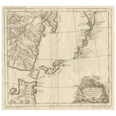
Antique map titled ?Japan?. Old map of Japan to illustrate a journey from the City of Yedo to the mountain of Fusi-Yama. Performed by Rutherford Allcock Esqr. C.B. 1860. Artists and Engravers: Published for the Journal of the Royal Geographical Society by J. Murray.
Artist: Published for the Journal of the Royal Geographical Society by J. Murray.
Condition: Fair, paper is creased. Please study image carefully.
Date: 1861
Overall size: 18.5 x 22.5 cm.
Image size: 13 x 18 cm.
We sell original antique maps to collectors, historians, educators and interior decorators all over the world. Our collection includes a wide range of authentic antique maps from the 16th to the 20th centuries. Buying and collecting antique maps is a tradition that goes back hundreds of years. Antique maps have proved a richly rewarding investment over the past decade, thanks to a growing appreciation of their unique historical appeal. Today the decorative qualities of antique maps are widely recognized by interior designers who appreciate their beauty and design flexibility. Depending on the individual map, presentation, and context, a rare or antique map can be modern, traditional, abstract, figurative, serious or whimsical. We offer a wide range of authentic antique maps for any budget.
- Dimensions:Height: 7.29 in (18.5 cm)Width: 8.86 in (22.5 cm)Depth: 0 in (0.01 mm)
- Materials and Techniques:
- Period:
- Date of Manufacture:1861
- Condition:
- Seller Location:Langweer, NL
- Reference Number:
About the Seller
5.0
Platinum Seller
These expertly vetted sellers are 1stDibs' most experienced sellers and are rated highest by our customers.
Established in 2009
1stDibs seller since 2017
1,947 sales on 1stDibs
Typical response time: <1 hour
- ShippingRetrieving quote...Ships From: Langweer, Netherlands
- Return PolicyA return for this item may be initiated within 14 days of delivery.
More From This SellerView All
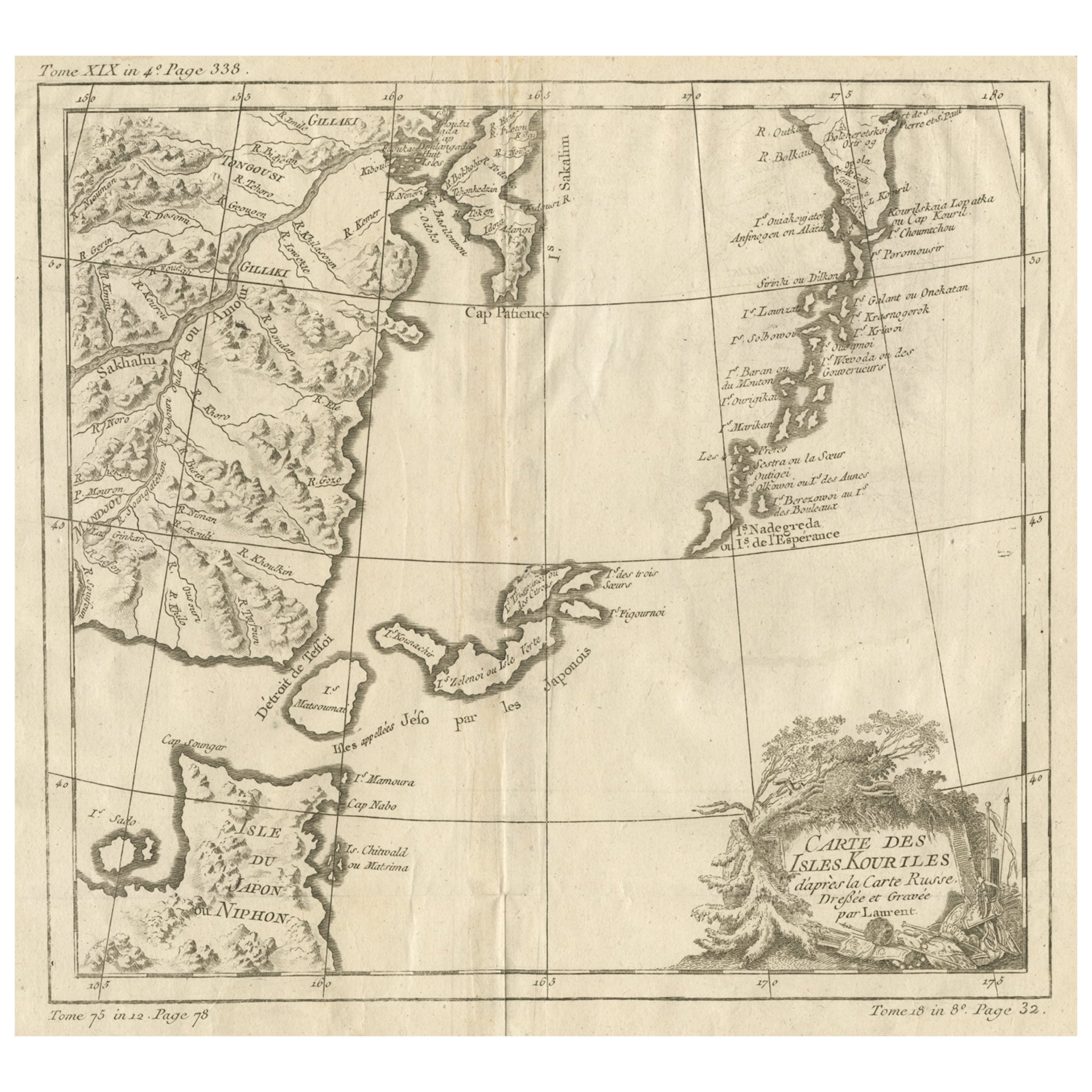
- Old Map of The Kurile Islands, from Hokkaido, Japan to Kamchatka, Russia, c.1750Located in Langweer, NLAntique map titled 'Carte des Iles Kouriles'. Original antique map of the Kuril Islands. The Kuril Islands or Kurile Islands are a volcanic archipelago that stretches approximate...Category
Antique 1750s Maps
MaterialsPaper
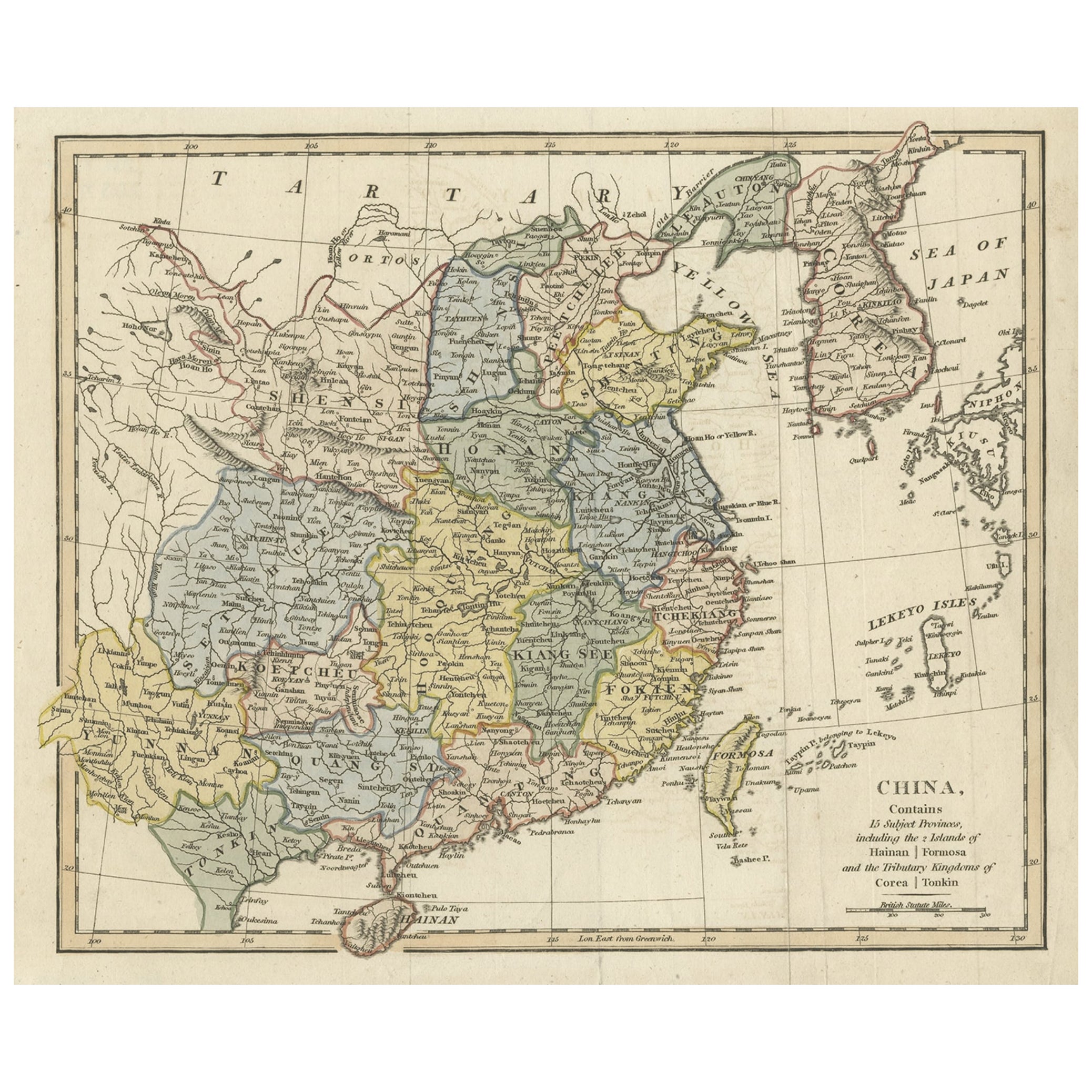
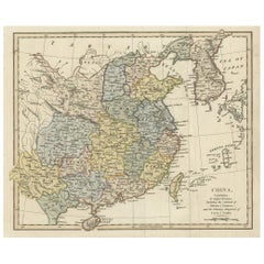
- Original Old China Map, From Korea and the Sea of Japan to Teypin Island, 1803Located in Langweer, NLAntique map titled 'China, Contains 15 Subject Provinces Including the 2 Islands of Hainan, Formosa and the Tributary Kingdoms of Corea, Tonkin'. Old map depicting China, extendi...Category
Antique Early 1800s Maps
MaterialsPaper
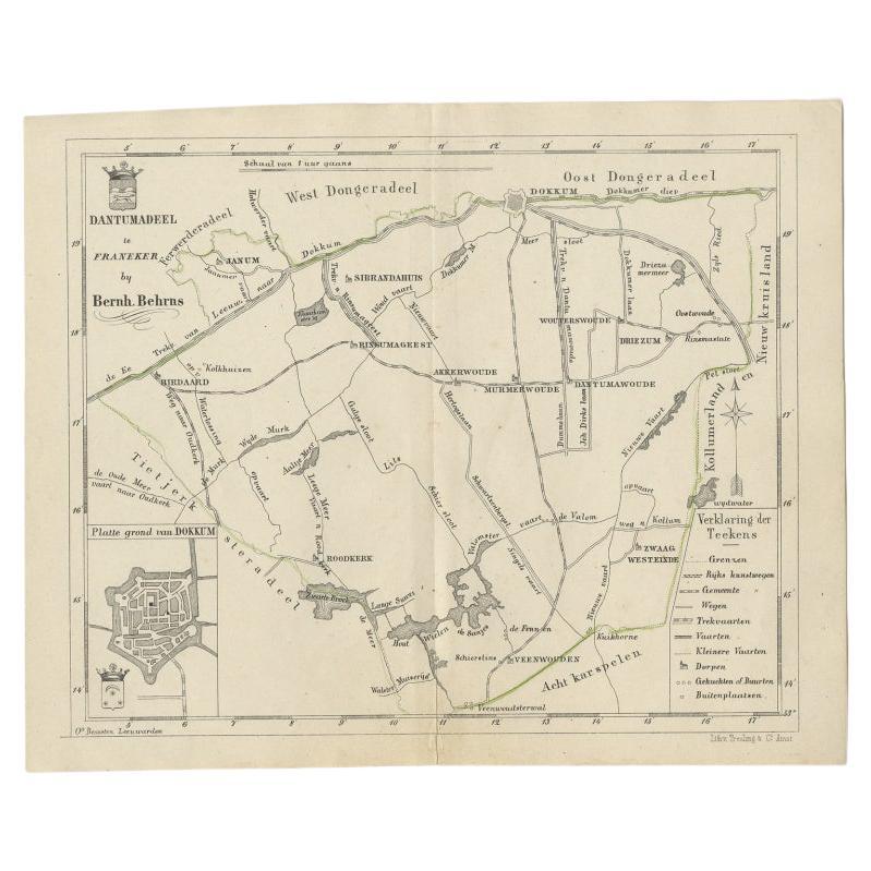
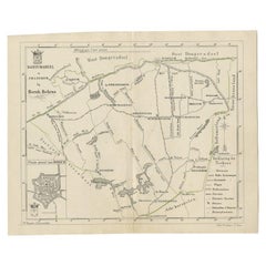
- Antique Map of the Dutch Dantumadeel Township, 1861Located in Langweer, NLAntique map titled 'Gemeente Dantumadeel'. Old map depicting the Dantumadeel township including cities and villages like Birdaard, Roodkerk, Veenwouden, Dantumawoude and Dokkum. This...Category
Antique 19th Century Maps
MaterialsPaper
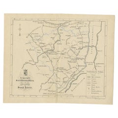
- Antique Map of The Dutch Township Rauwerderhem, 1861Located in Langweer, NLAntique map titled 'Gemeente Rauwerderhem'. Old map depicting the Rauwerderhem township including cities and villages like Deersum, Poppingawier, Rauwerd and Irnsum. This map orginat...Category
Antique 19th Century Maps
MaterialsPaper
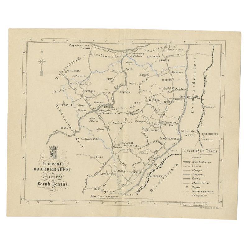
- Antique Map of the Dutch Township Baarderadeel, 1861Located in Langweer, NLAntique map titled 'Gemeente Baarderadeel'. Old map depicting the Baarderadeel township including cities and villages like Baard, Hilaard, Jorwerd, Oosterlittens and Oosterwierum. Th...Category
Antique 19th Century Maps
MaterialsPaper
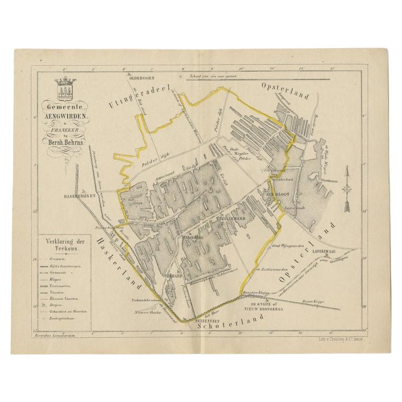
- Antique Map of the Dutch Township Aengwirden, 1861Located in Langweer, NLAntique map titled 'Gemeente Aengwirden'. Old map depicting the Aengwirden township including cities and villages like Tjalleberd, Luinjeberd, Terband and Gersloot. This map orginate...Category
Antique 19th Century Maps
MaterialsPaper


You May Also Like
- 1861 Topographical Map of the District of Columbia, by Boschke, Antique MapLocated in Colorado Springs, COPresented is an original map of Albert Boschke's extremely sought-after "Topographical Map of the District of Columbia Surveyed in the Years 1856 ...Category
Antique 1860s American Historical Memorabilia
MaterialsPaper
- Original Antique Map of Indonesia, 1861Located in St Annes, LancashireGreat map of Indonesia Drawn and engraved by Edward Weller Original color Published in The Weekly Dispatch Atlas, 1861 Repairs to minor e...Category
Antique 1860s English Victorian Maps
MaterialsPaper

- 1880s Map of The Italian Alps from Milan to Lake GardaLocated in Roma, ITGeographical Map of the Profile and Elevation of the Italian Alps from Milano to Lake Garda. The map features the name of each peak and key cities including Monza, Brescia and Bergam...Category
Antique 1880s Italian Maps
MaterialsParchment Paper
- Old Nautical Map of CorsicaLocated in Alessandria, PiemonteST/556/1 - Old map of Corsica isle, surveyed by Captain Hell, of the French Royal Navy in 1824, engraved and published on 1874, with additions and corre...Category
Antique Early 19th Century English Other Prints
MaterialsPaper
- Old Horizontal Map of EnglandBy TassoLocated in Alessandria, PiemonteST/520 - Old rare Italian map of England, dated 1826-1827 - by Girolamo Tasso, editor in Venise, for the atlas of M.r Le-Sage.Category
Antique Early 19th Century Italian Other Prints
MaterialsPaper
- 1861 The Book of Household ManagementBy Isabella BeetonLocated in Bath, GBThe first edition of Mrs Isabella Beeton's important cookery work, one of the most influential of its genre ever publisher, complete here with the original colour plates. The first ...Category
Antique 1860s Books
MaterialsPaper