Items Similar to Original Antique Bird's-Eye View of Colmar, Alsace, France, 1552
Want more images or videos?
Request additional images or videos from the seller
1 of 5
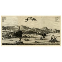
Original Antique Bird's-Eye View of Colmar, Alsace, France, 1552
About the Item
Antique map titled 'La Paincture de la cité de Colmar & du pais circonuoisin'.
Original antique bird's-eye view of Colmar, Alsace, France. This map originates from 'La Cosmographie Universelle' by S. Münster. Published 1552.
Artists and Engravers: Sebastian Münster (1488-1552) was a cosmographer and professor of Hebrew who taught at Tübingen, Heidelberg, and Basel. He settled in the latter in 1529 and died there, of plague, in 1552. Münster made himself the center of a large network of scholars from whom he obtained geographic descriptions, maps, and directions.
- Dimensions:Height: 12.41 in (31.5 cm)Width: 15.16 in (38.5 cm)Depth: 0 in (0.02 mm)
- Materials and Techniques:
- Period:
- Date of Manufacture:1552
- Condition:Wear consistent with age and use. Condition: Good, general age-related toning. Original folding line. Minor wear/creasing, French text on verso. Please study image carefully.
- Seller Location:Langweer, NL
- Reference Number:
About the Seller
5.0
Platinum Seller
These expertly vetted sellers are 1stDibs' most experienced sellers and are rated highest by our customers.
Established in 2009
1stDibs seller since 2017
1,933 sales on 1stDibs
Typical response time: <1 hour
- ShippingRetrieving quote...Ships From: Langweer, Netherlands
- Return PolicyA return for this item may be initiated within 14 days of delivery.
More From This SellerView All
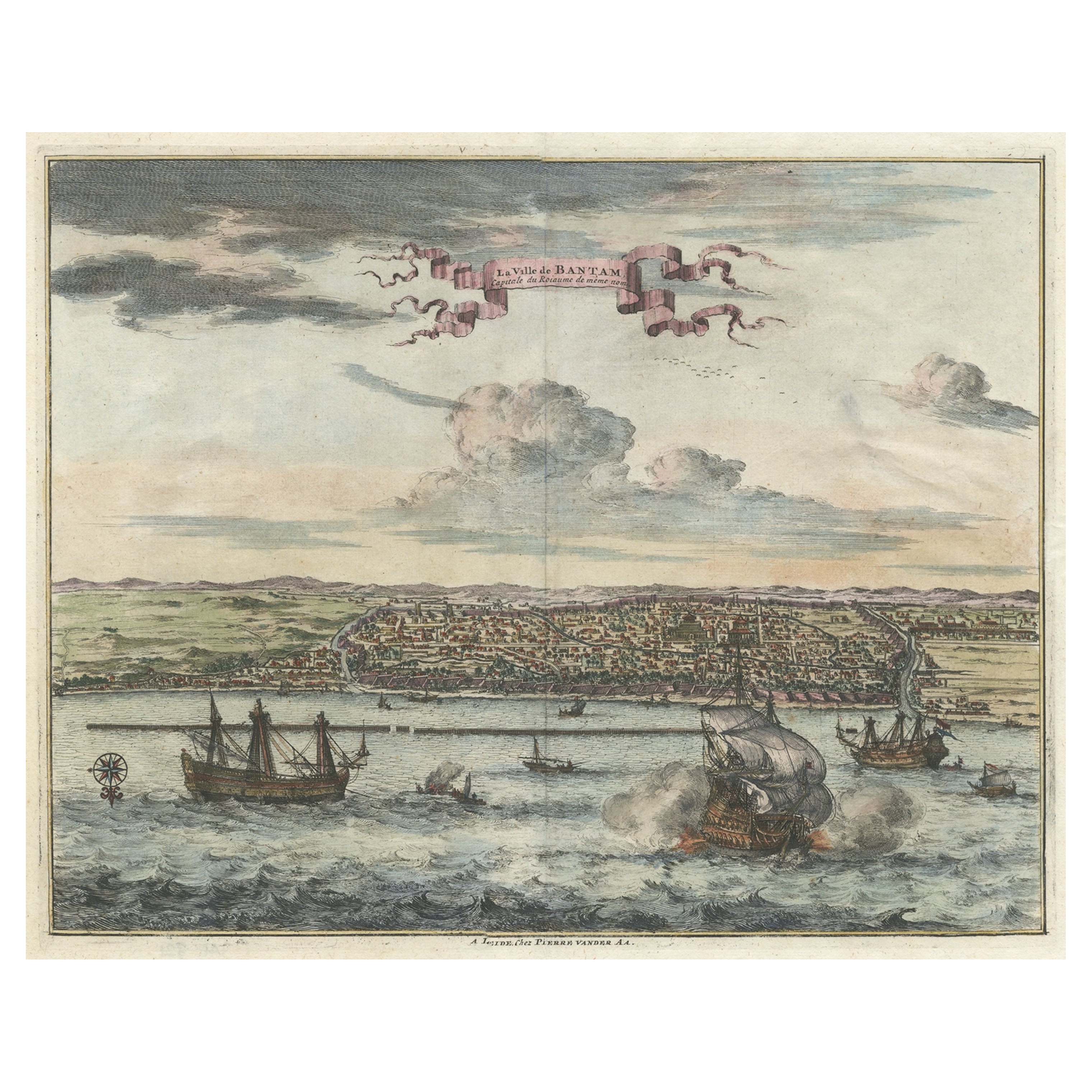
- Original Antique Bird's Eye View of Banten or Bantam in Java, Indonesia, 1725Located in Langweer, NLAntique print titled 'La Ville de Bantam capitale du Roiaume de meme nom'. A bird's eye view of the city Banten or Bantam near the western end of Java in Indonesia. Several tall ...Category
Antique 1720s Prints
MaterialsPaper
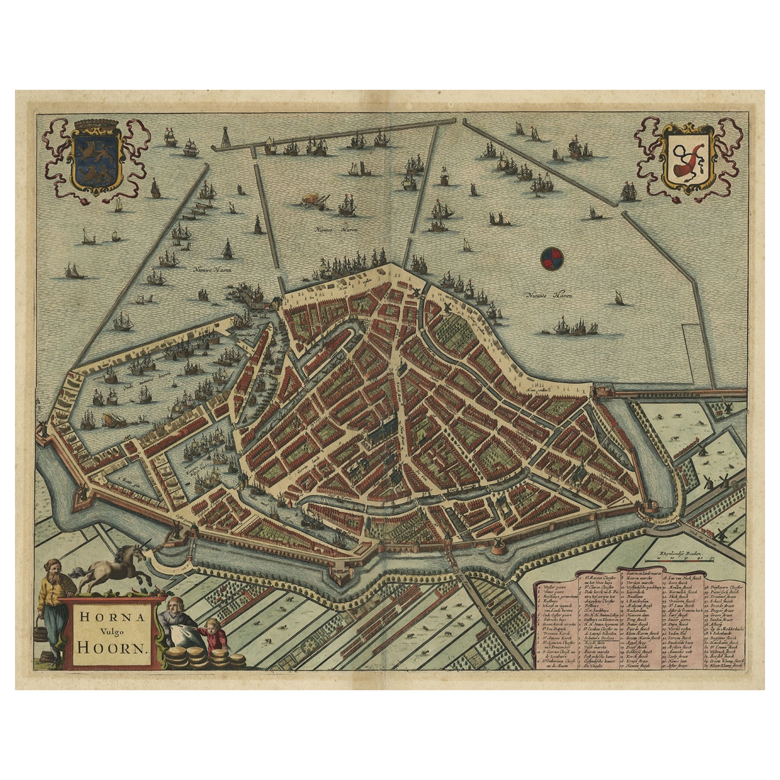
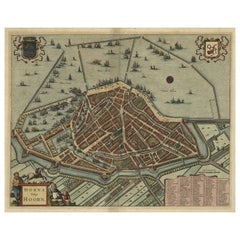
- Original Antique Bird's Eye View Plan of Hoorn, The Netherlands by Blaeu, c.1700Located in Langweer, NLAntique map titled 'Horna vulgo Hoorn'. Bird's eye view plan of Hoorn, The Netherlands. With title cartouche, coats of arms and key. From an atlas published by De Wit, ca. 1698-1...Category
Antique Early 1700s Maps
MaterialsPaper
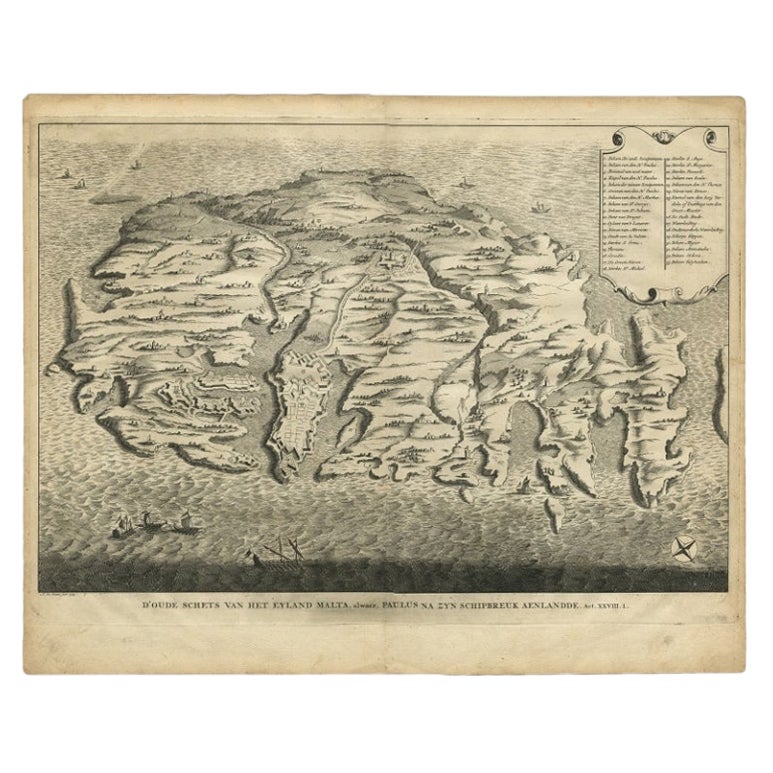
- Rare Antique Bird's-eye View Map of The Island of Malta, 1729Located in Langweer, NLAntique print titled 'D'oude Schets van het Eyland Malta, alwaer, Paulus na zyn Schipbreuk Aenlandde.' This is an uncommon bird's-eye view map of the island of Malta. The map pre...Category
Antique 18th Century Maps
MaterialsPaper
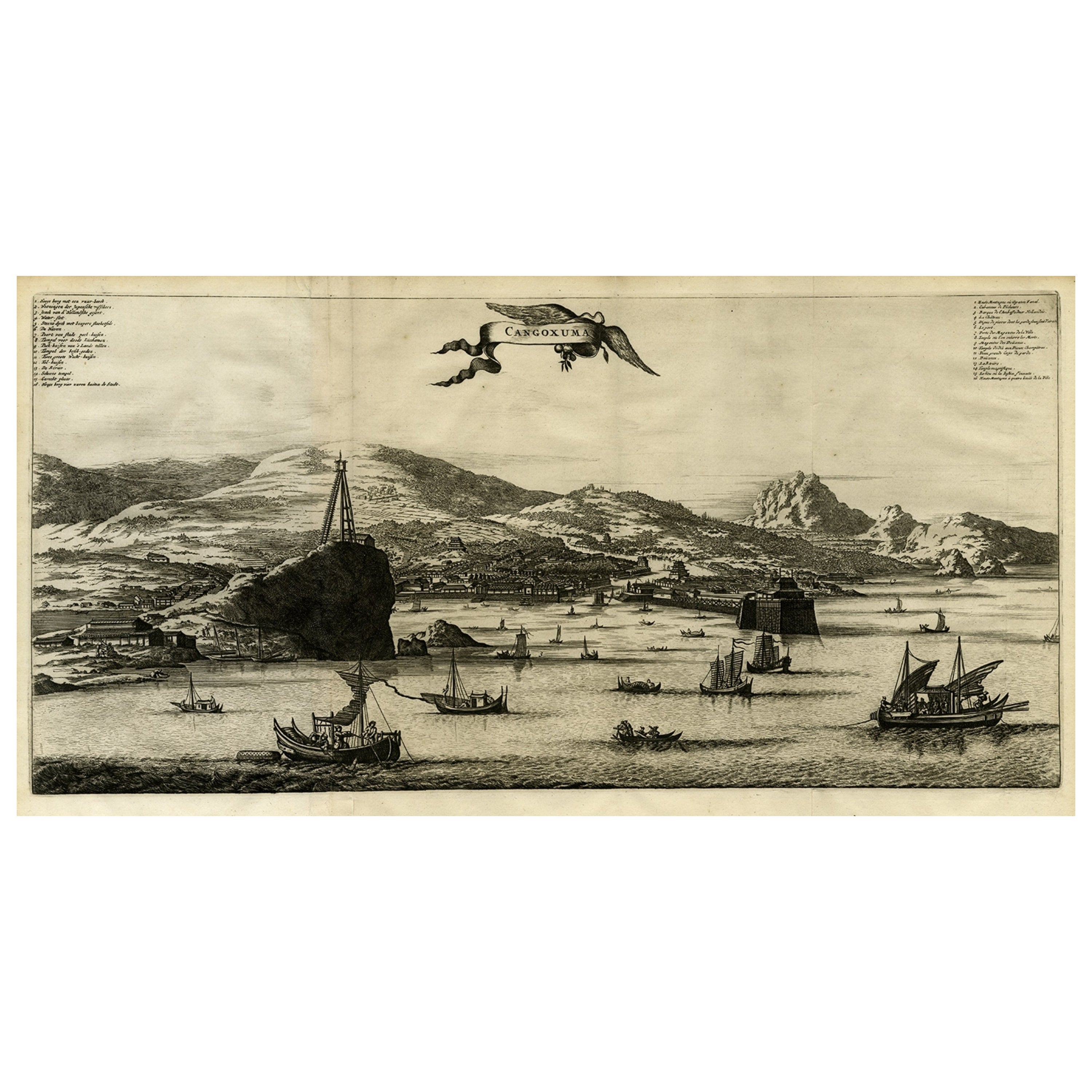
- Original Old Engraving, Bird's Eye View of Cangoxuma (Kagoshima) in Japan, 1669Located in Langweer, NLRare Antique print, titled: 'Cangoxuma.' A stunning bird's eye view of the coastal city Cangoxuma (Kagoshima) in Japan. It shows several boats in the harbour, as well as the ligh...Category
Antique 1660s Maps
MaterialsPaper
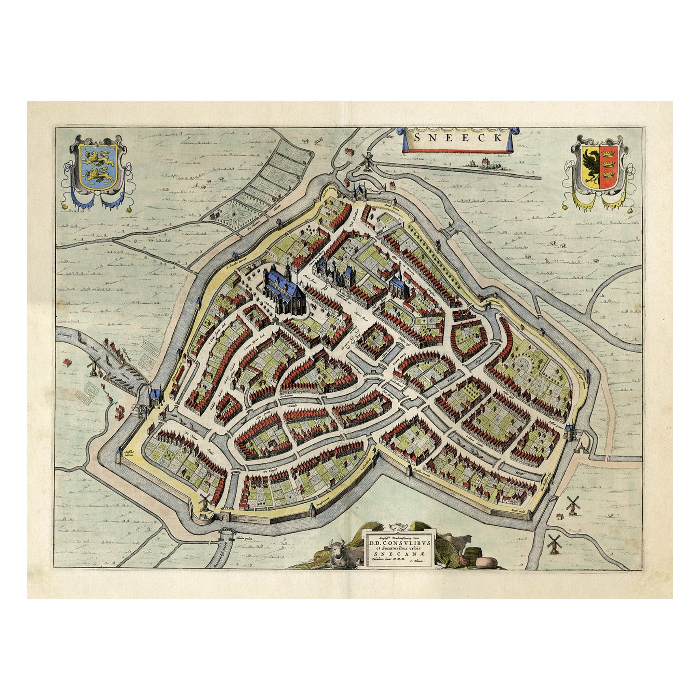
- Original Old Bird's-eye View plan of Sneek, Friesland, The Netherlands, 1649Located in Langweer, NLAntique map titled: 'Sneeck.' Bird's-eye view plan of Sneek, Friesland, The Netherlands. Text in Latin on verso. This plan originates from the famous city Atlas: 'Toneel der Steeden'...Category
Antique 1640s Maps
MaterialsPaper
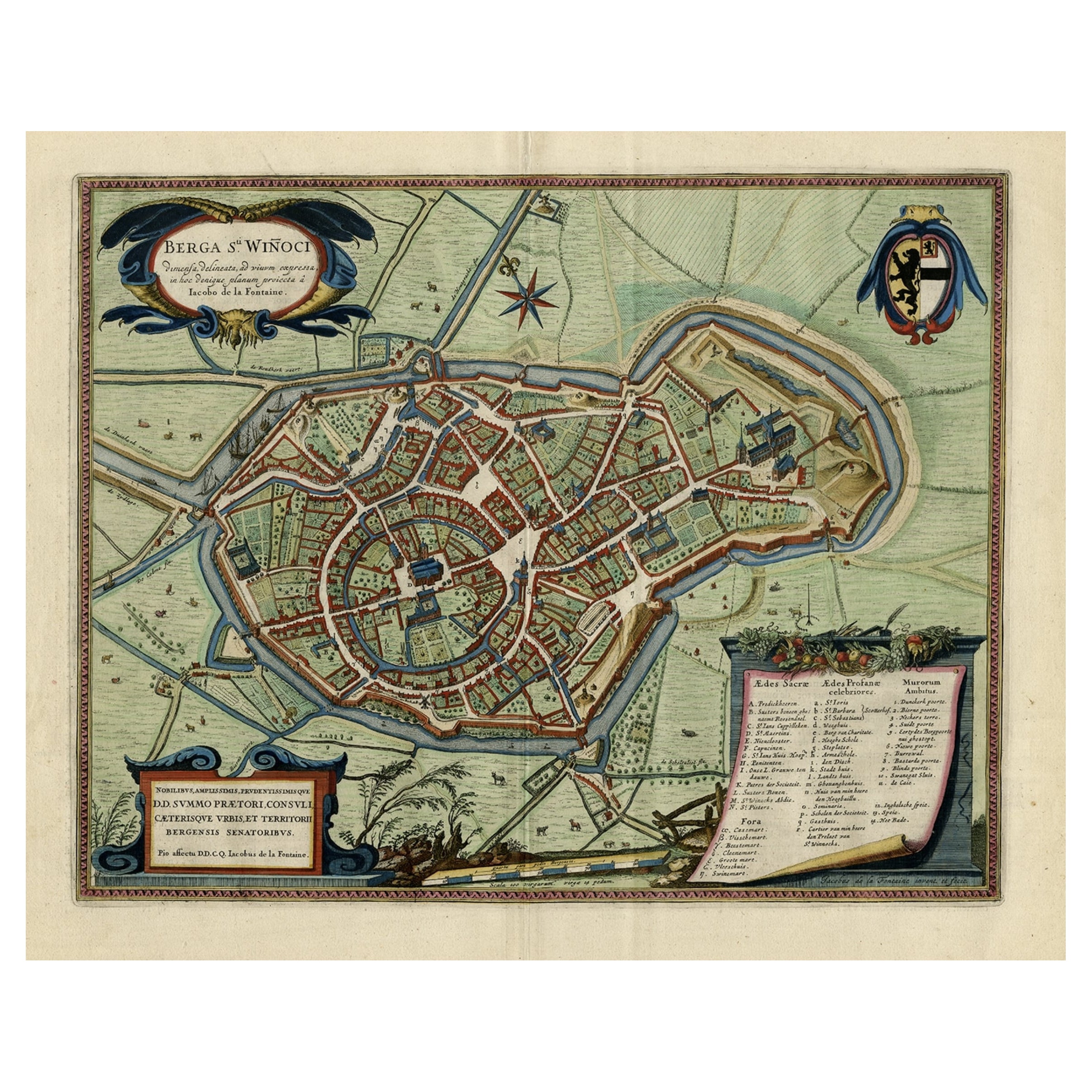
- Original Old Bird's-Eye View Plan of Sint-Winoksbergen or Bergen in France, 1649Located in Langweer, NLAntique map titled 'Berga Sti Winoci.' - Bird's-eye view plan of Sint-Winoksbergen in France, with key to locations and coats of arms. Text in Dutch on verso. This plan originates from the famous city Atlas: 'Toneel der Steeden' published by Joan Blaeu...Category
Antique 1640s Maps
MaterialsPaper

You May Also Like
- Original Antique Map of France, Arrowsmith, 1820Located in St Annes, LancashireGreat map of France Drawn under the direction of Arrowsmith. Copper-plate engraving. Published by Longman, Hurst, Rees, Orme and Brown, 1820 Unframed.Category
Antique 1820s English Maps
MaterialsPaper
- Original Antique Map of France, Sherwood, Neely & Jones, Dated 1809Located in St Annes, LancashireGreat map of France Copper-plate engraving by Cooper Published by Sherwood, Neely & Jones. Dated 1809 Unframed.Category
Antique Early 1800s English Maps
MaterialsPaper
- Original Antique Map of Italy. C.1780Located in St Annes, LancashireGreat map of Italy Copper-plate engraving Published C.1780 Unframed.Category
Antique Early 1800s English Georgian Maps
MaterialsPaper

- Original Antique Map of Asia. C.1780Located in St Annes, LancashireGreat map of Asia Copper-plate engraving Published C.1780 Two small worm holes to right side of map Unframed.Category
Antique Early 1800s English Georgian Maps
MaterialsPaper

- Original Antique Map of India. C.1780Located in St Annes, LancashireGreat map of India Copper-plate engraving Published C.1780 Three small worm holes to right side of map and one bottom left corner Unframed.Category
Antique Early 1800s English Georgian Maps
MaterialsPaper

- Original Antique Map of China, Arrowsmith, 1820Located in St Annes, LancashireGreat map of China Drawn under the direction of Arrowsmith Copper-plate engraving Published by Longman, Hurst, Rees, Orme and Brown, 1820 Unfr...Category
Antique 1820s English Maps
MaterialsPaper


Recently Viewed
View AllMore Ways To Browse
Antique Eye
Antique Bird Study
Bird French Antiques
Original Antique Birds
Alsace French
Alsace Furniture
Antique Hebrew
Pai Pai
Pai Of
Hebrew Antique
Birds Eye View Map
Alsace Map
Sebastian Munster
Antique Map Munster
Antique French Globe
18th Century Southern Antiques
South African Antique Furniture
Antique Furniture South Africa