Items Similar to Original Antique Map of Arabia and the Red Sea, circa 1750
Want more images or videos?
Request additional images or videos from the seller
1 of 11
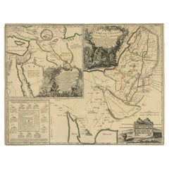
Original Antique Map of Arabia and the Red Sea, circa 1750
$448.53
$560.6720% Off
£331.61
£414.5120% Off
€376
€47020% Off
CA$616.95
CA$771.1920% Off
A$685.78
A$857.2320% Off
CHF 359.47
CHF 449.3420% Off
MX$8,375.05
MX$10,468.8120% Off
NOK 4,487.80
NOK 5,609.7520% Off
SEK 4,222.18
SEK 5,277.7320% Off
DKK 2,862.48
DKK 3,578.1020% Off
About the Item
Antique map titled 'Carte de la Coste d'Arabie (..) - Kaart van de Kust van Arabië (..)'. This is a Dutch version, engraved by J. van Schley, of Bellin's map of Arabia and the Red Sea. The emphasis is the coastlines and the interior is primarily left blank. The shoals and navigational hazards in the Red Sea and the pearl banks off the coast of Bahrain are also noted. The Persian Gulf is depicted too wide and too far north. This map is more elaborately decorated with a flourishing title cartouche and a compass rose. Originates from a Dutch edition of Prevost's 'Histoire Generale des Voyages' published circa 1750.
- Dimensions:Height: 9.97 in (25.3 cm)Width: 11.15 in (28.3 cm)Depth: 0.02 in (0.5 mm)
- Materials and Techniques:Paper,Engraved
- Place of Origin:
- Period:
- Date of Manufacture:c.1750
- Condition:General age-related toning. A few defects, most in margins, only sl. affecting image. Some wear and soiling. Blank verso. Please study image carefully.
- Seller Location:Langweer, NL
- Reference Number:Seller: BG-13366-41stDibs: LU3054333938112
About the Seller
5.0
Recognized Seller
These prestigious sellers are industry leaders and represent the highest echelon for item quality and design.
Platinum Seller
Premium sellers with a 4.7+ rating and 24-hour response times
Established in 2009
1stDibs seller since 2017
2,607 sales on 1stDibs
Typical response time: <1 hour
- ShippingRetrieving quote...Shipping from: Langweer, Netherlands
- Return Policy
Authenticity Guarantee
In the unlikely event there’s an issue with an item’s authenticity, contact us within 1 year for a full refund. DetailsMoney-Back Guarantee
If your item is not as described, is damaged in transit, or does not arrive, contact us within 7 days for a full refund. Details24-Hour Cancellation
You have a 24-hour grace period in which to reconsider your purchase, with no questions asked.Vetted Professional Sellers
Our world-class sellers must adhere to strict standards for service and quality, maintaining the integrity of our listings.Price-Match Guarantee
If you find that a seller listed the same item for a lower price elsewhere, we’ll match it.Trusted Global Delivery
Our best-in-class carrier network provides specialized shipping options worldwide, including custom delivery.More From This Seller
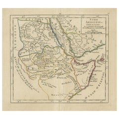
View AllOld Map of the Arabian Peninsula with Parts of Egypt, Sudan, Eritrea & Ethiopia
Located in Langweer, NL
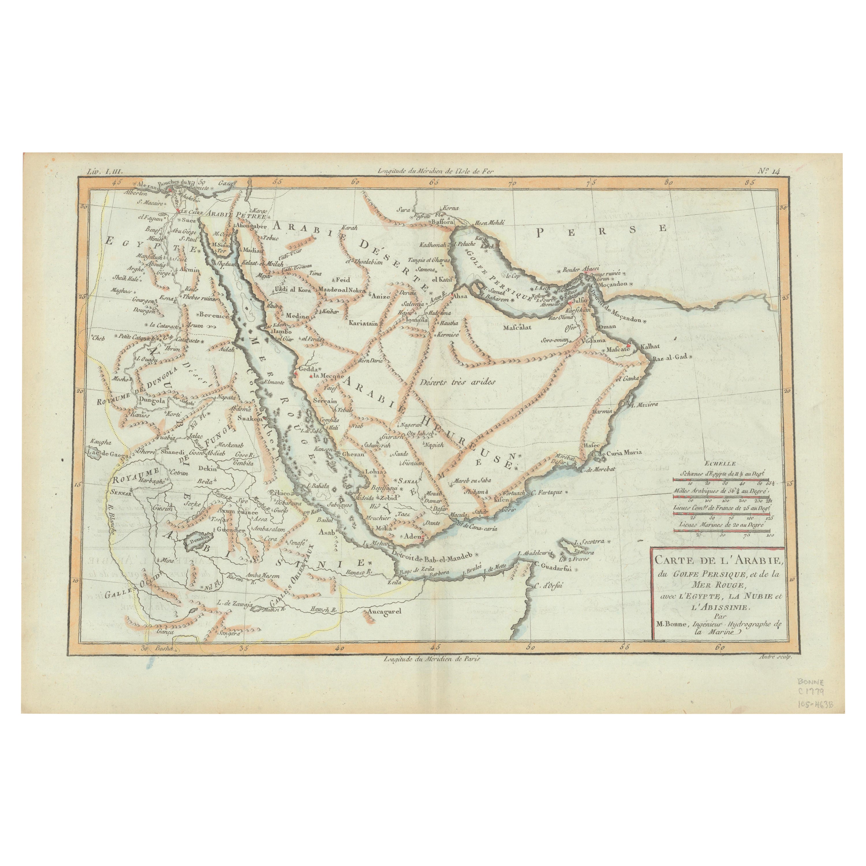
"Carte de l'Arabie, du Golfe Persique, et de la Mer Rouge, avec l'Egypte, la Nubie et l'Abissinie", Bonne, Rigobert
Subject: Arabia
Period: 1780 (circa)
Publication: Atlas de Toutes...
Category
Antique 1780s Maps
Materials
Paper
$362 Sale Price
20% Off
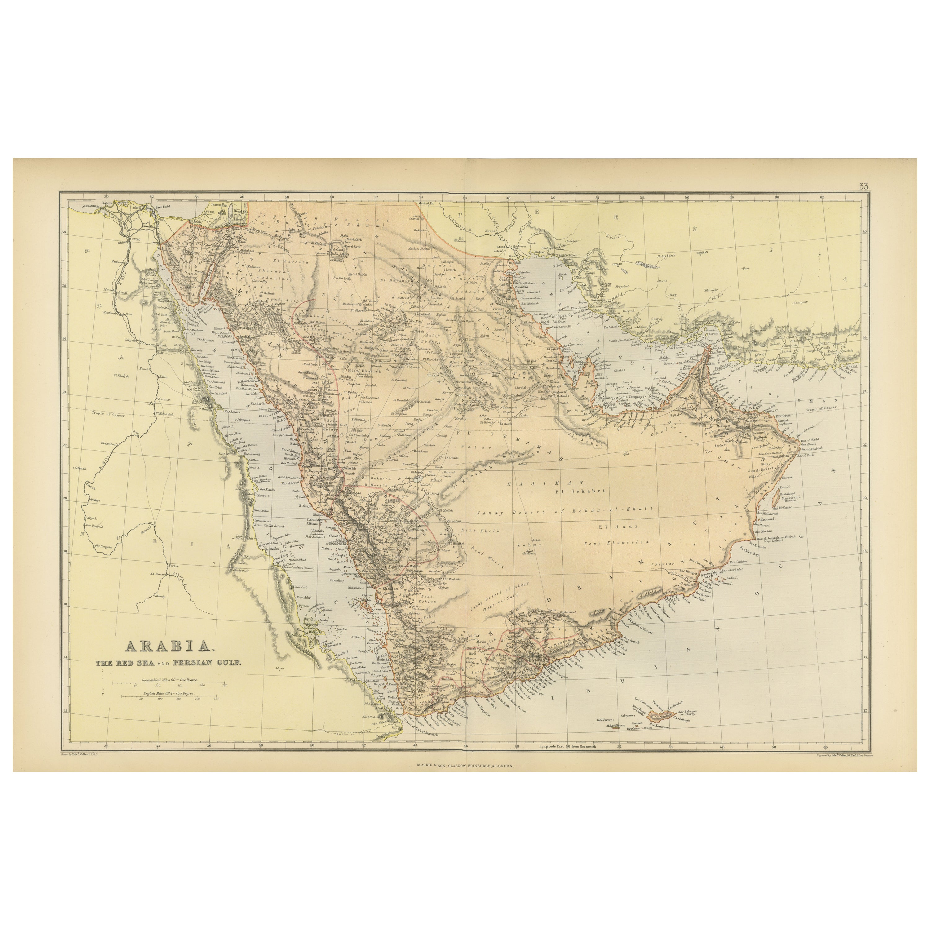
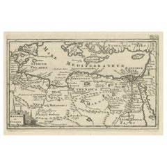
Original 1882 Map of Arabia, Red Sea & Persian Gulf
Located in Langweer, NL
This print is a historically significant map titled "Arabia, the Red Sea, and the Persian Gulf," originally published in 1882 as part of the 'Comprehensive Atlas and Geography of the...
Category
Antique 1880s Maps
Materials
Paper
$334 Sale Price
20% Off
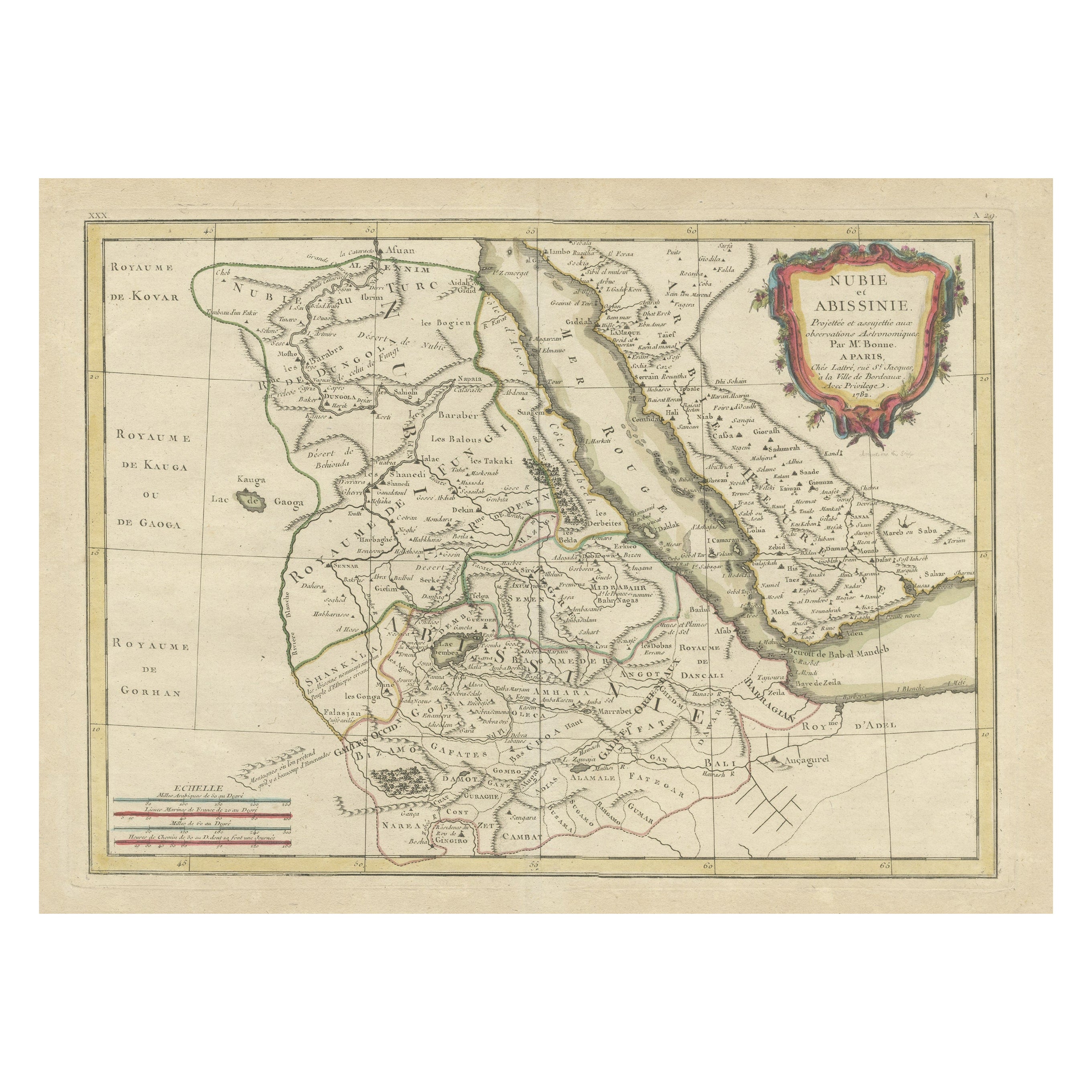
Antique Map of Arabia including Nubia and Abyssinia, also shows the Red Sea
Located in Langweer, NL
Antique map titled 'Nubie et Abissinie'. Original antique map of Nubia, a region along the Nile river, and Abyssinia or the Ethiopian Empire. This map o...
Category
Antique Late 18th Century Maps
Materials
Paper

$820 Sale Price
20% Off
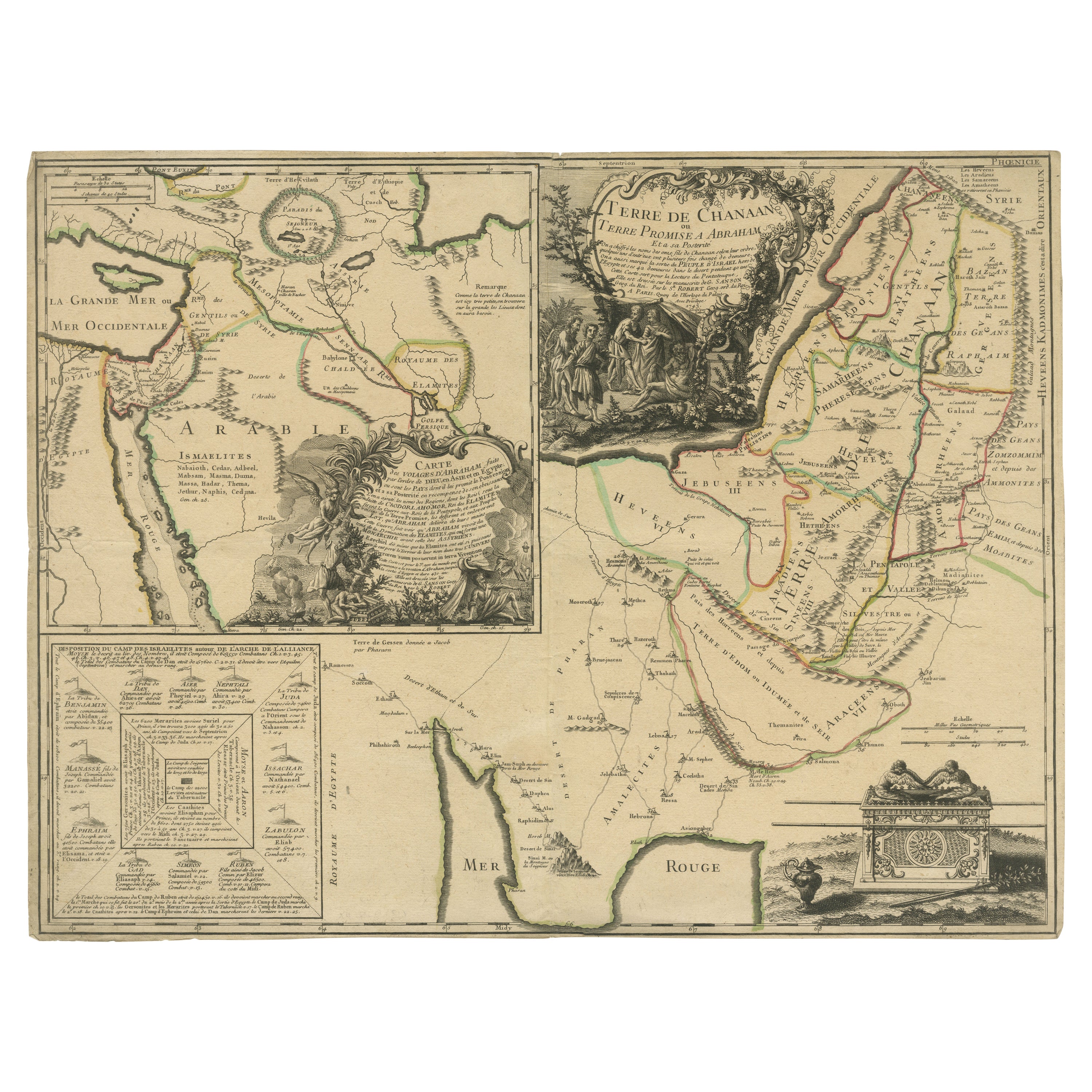
Old Map of Arabian Peninsula and Canaan, Highlighting Biblical Territories, 1750
Located in Langweer, NL
This antique map, titled "Terre de Chanaan ou Terre Promise a Abraham," is a finely detailed copper-engraved map created around 1750 by Delamarche in Paris, based on earlier works by...
Category
Antique 1750s French Maps
Materials
Paper
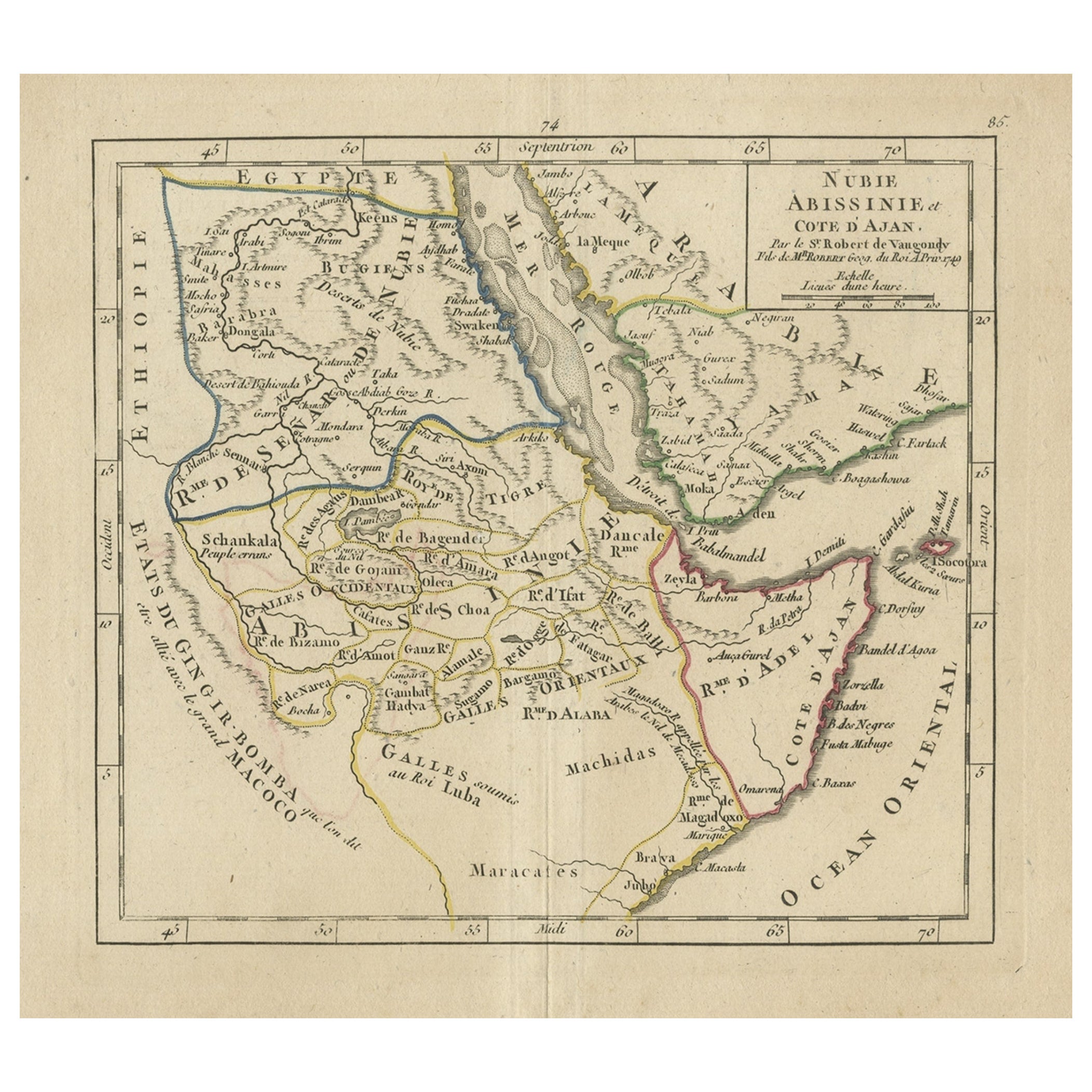
Original Antique Map of Abyssinia, Sudan and the Red Sea, 1749
Located in Langweer, NL
Antique map titled 'Nubie, Abissinie et Cote d'Ajan'.
Map of Abyssinia, Sudan and the Red Sea by Robert Vaugondy. Covers from Arabia and Egypt south to M...
Category
Antique 1740s Maps
Materials
Paper
$324 Sale Price
20% Off
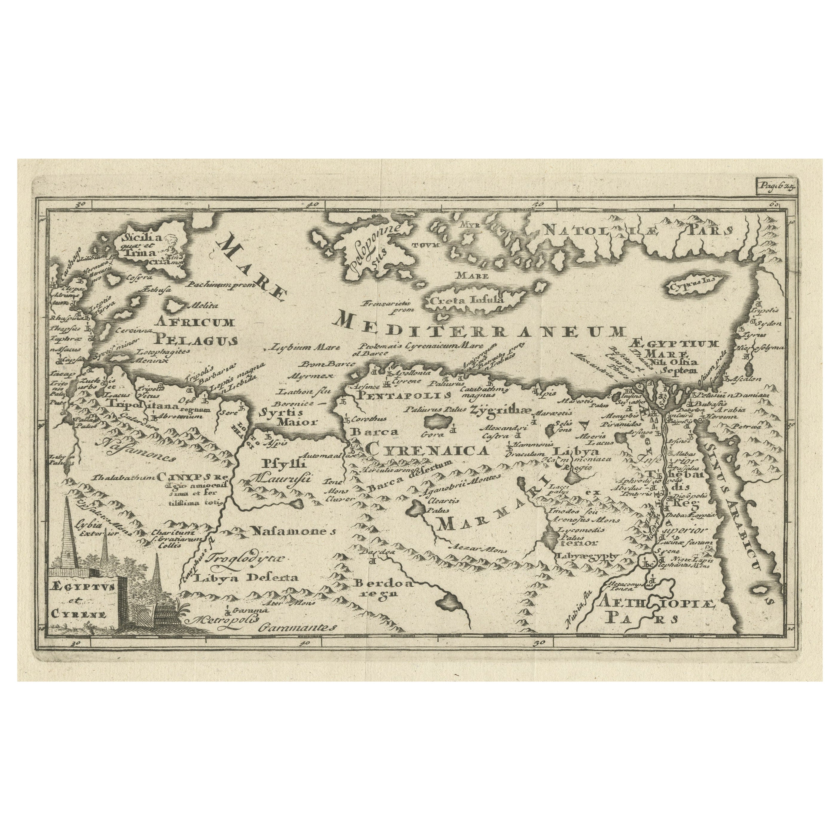
Original Antique Map of the Region Between the Gulf of Lybia and the Red Sea
Located in Langweer, NL
Original antique map titled 'Aegyptus et Cyrene'. Detailed ancient map of the region between the Gulf of Lybia and the Red Sea, with marvelous detail along the Mediterranean Coastline and the Nile, Egypt. This map originates from 'Philippi Cluveri Introductionis in universam geographiam (..)' by P. Clüver. Published 1729.
Philipp Clüver was an Early Modern German geographer and historian. Cluver's Geography was one of the most enduring works of the 17th & 18th Centuries, issued by several different publishers with many different sets of maps...
Category
Antique Early 18th Century Maps
Materials
Paper
$400 Sale Price / item
20% Off
You May Also Like
Large Original Antique Map of Morocco. Edward Weller, 1861
Located in St Annes, Lancashire
Great map of Morocco
Lithograph engraving by Edward Weller
Original colour
Published, 1861
Unframed
Good condition.
Category
Antique 1860s English Victorian Maps
Materials
Paper

Map of the Holy Land "Carte de la Syrie et de l'Egypte" by Pierre Lapie
By Pierre M. Lapie
Located in Alamo, CA
This is an early 19th century map of ancient Syria and Egypt entitled "Carte de la Syrie et de l'Egypte anciennes/dressée par M. Lapie, Colonel d'Etat M...
Category
1830s Landscape Prints
Materials
Engraving

Antique 1803 Italian Map of Asia Including China Indoneseia India
Located in Amsterdam, Noord Holland
Antique 1803 Italian Map of Asia Including China Indoneseia India
Very nice map of Asia. 1803.
Additional information:
Type: Map
Country of Manufacturing: Europe
Period: 19th centu...
Category
Antique 19th Century European Maps
Materials
Paper

$584 Sale Price
20% Off
London 1744 Published Watercolour Antique Map of East Africa by Eman Bowen
Located in West Sussex, Pulborough
We are delighted to offer for sale this New and Accurate Map of Nubia & Abissinia, together with all the Kingdoms Tributary Thereto, and bordering upon them published in 1744 by Emanuel Bowen
This is a decorative antique engraved map of East Africa...
Category
Antique 1740s English George III Maps
Materials
Paper

$917 Sale Price
30% Off
Africa. North-East Part. Century Atlas antique vintage map
Located in Melbourne, Victoria
'The Century Atlas. Africa. North-East Part'
Original antique map, 1903.
Inset map of 'Nile Delta and Suez Canal'.
Central fold as issued. Map name and nu...
Category
Early 20th Century Victorian More Prints
Materials
Lithograph

Antique French Map of Asia Including China Indoneseia India, 1783
Located in Amsterdam, Noord Holland
Very nice map of Asia. 1783 Dedie au Roy.
Additional information:
Country of Manufacturing: Europe
Period: 18th century Qing (1661 - 1912)
Condition: Overall Condition B (Good Used)...
Category
Antique 18th Century European Maps
Materials
Paper

$648 Sale Price
20% Off