Items Similar to Original Antique Map of Fez and Morocco


Want more images or videos?
Request additional images or videos from the seller
1 of 6
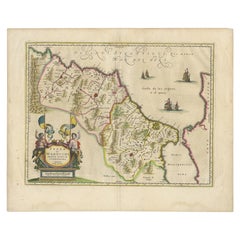
Original Antique Map of Fez and Morocco
About the Item
Antique map titled 'Karte von Fes und Marócos (..)'. Original old map of Fez (or Fes) and Morocco. Also shows the Strait of Gibraltar. By Friedrich Gottlieb Canzler, published 1799.
- Dimensions:Height: 13.31 in (33.8 cm)Width: 14.85 in (37.7 cm)Depth: 0.02 in (0.5 mm)
- Materials and Techniques:
- Period:
- Date of Manufacture:1799
- Condition:General age-related toning. Shows some wear and soiling and a few small weak spots (for example bottom right). Blank verso. Please study image carefully.
- Seller Location:Langweer, NL
- Reference Number:
About the Seller
5.0
Platinum Seller
These expertly vetted sellers are 1stDibs' most experienced sellers and are rated highest by our customers.
Established in 2009
1stDibs seller since 2017
1,946 sales on 1stDibs
Typical response time: <1 hour
- ShippingRetrieving quote...Ships From: Langweer, Netherlands
- Return PolicyA return for this item may be initiated within 14 days of delivery.
More From This SellerView All
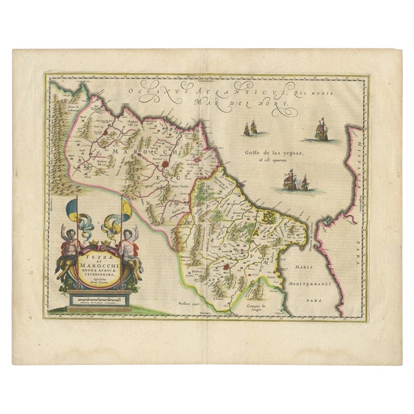
- Antique Map of Morocco Showing Towns of Marakesh, Taradant and Fez, 1636Located in Langweer, NLAntique map titled 'Fezzae et Marocchi regna Africae Celeberrima'. Map of Morocco, showing large fortified towns of Marakesh, Taradante and Fez, towns, mountains, rivers, lakes, etc....Category
Antique 17th Century Maps
MaterialsPaper
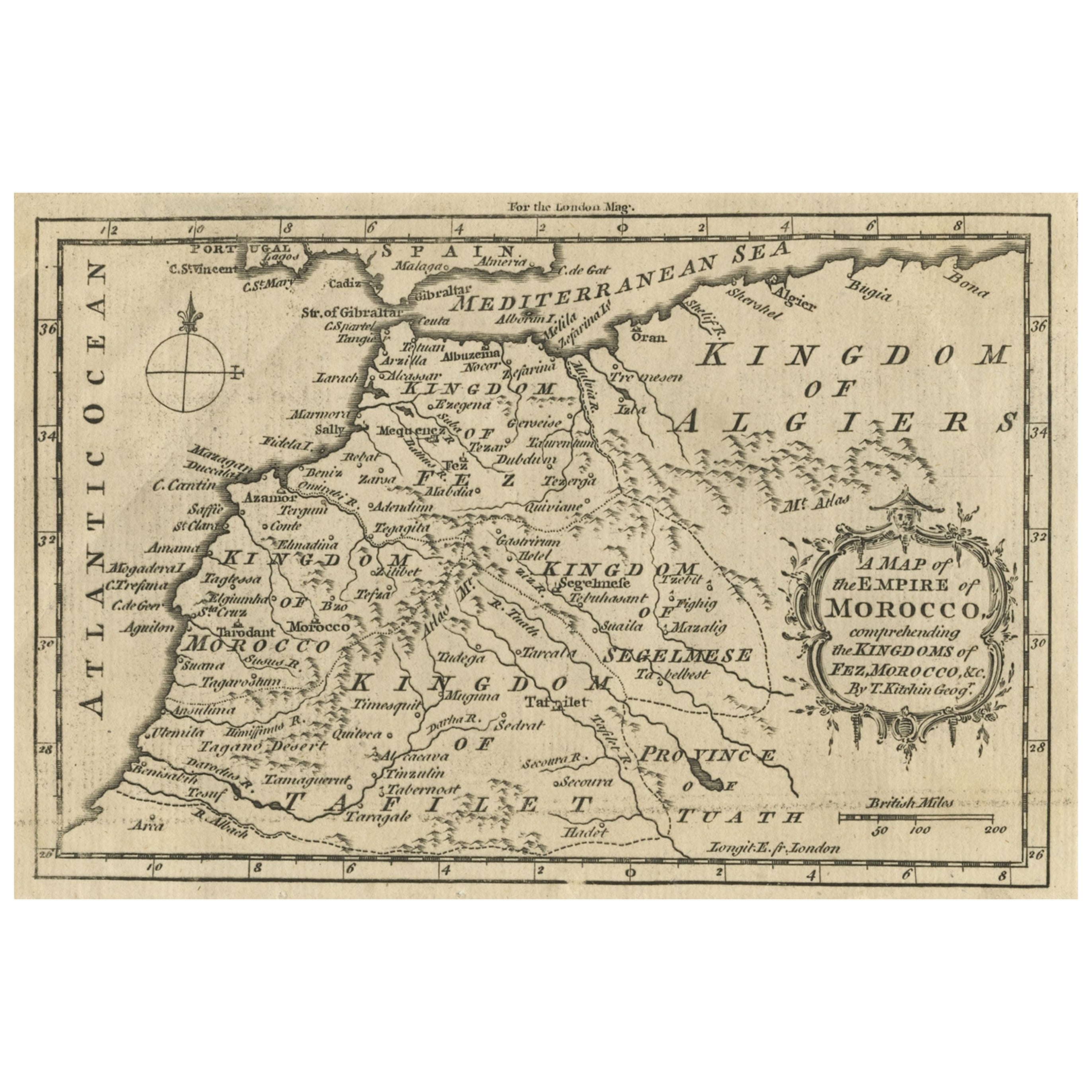
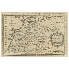
- Old Map of the Kingdoms of Fez, Algiers, Segelmese, Tafilet and Morocco, ca.1760Located in Langweer, NLAntique map titled 'A Map of the Empire of Morocco Comprehending the Kingdoms of Fez, Morocco'. Original antique map of the kingdoms of Fez, Algiers, Segelmese, Tafilet and Moroc...Category
Antique 1760s Maps
MaterialsPaper
- Original Antique Map of England and WalesLocated in Langweer, NLAntique map titled 'A New and Correct Map of England and Wales from the Latest and Best Improvements'. Original antique map of England and Wales. Printed by Alex Hogg, London for George Henry Millar's 'New, Complete and Universal System...Category
Antique Late 18th Century Maps
MaterialsPaper
- Original Antique Map of AfricaLocated in Langweer, NLAntique map titled 'Afrika'. Original antique map of Africa, drawn by Van Beusekom. Published by 'Seyffardt's Boekhandel' in Amsterdam, circa 1870.Category
Antique Late 19th Century Maps
MaterialsPaper
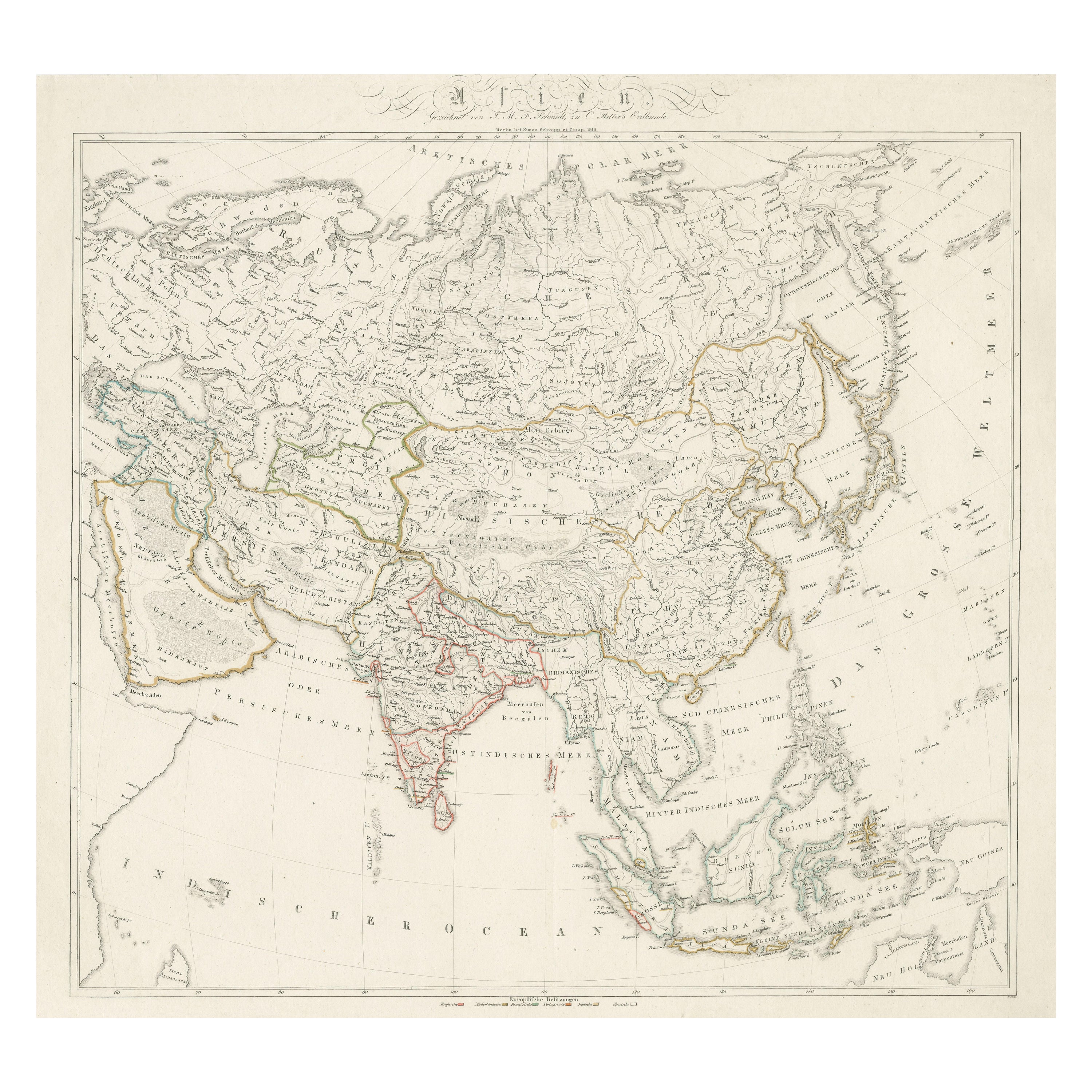
- Original Antique Map of AsiaLocated in Langweer, NLAntique map titled 'Asien'. Original old map of Asia. Published in Berlin by Simon Schropp et Comp, 1819.Category
Antique Early 19th Century Maps
MaterialsPaper
- Original Antique Map of Greece and part of TurkeyLocated in Langweer, NLOriginal antique map titled 'La Grece ou partie meridionale de la Turquie d'Europe'. Small map of Greece and part of Turkey. This map originates from 'Le nouveau et curieux Atlas Geo...Category
Antique Early 18th Century Maps
MaterialsPaper


You May Also Like
- Original Antique Map of Ireland- Tipperary and Waterford. C.1840Located in St Annes, LancashireGreat map of Tipperary and Waterford Steel engraving Drawn under the direction of A.Adlard Published by How and Parsons, C.1840 Unframed.Category
Antique 1840s English Maps
MaterialsPaper
- Original Antique Map of Spain and Portugal, circa 1790Located in St Annes, LancashireSuper map of Spain and Portugal Copper plate engraving by A. Bell Published, circa 1790. Unframed.Category
Antique 1790s English Other Maps
MaterialsPaper
- Original Antique Map of Italy. Arrowsmith. 1820Located in St Annes, LancashireGreat map of Italy Drawn under the direction of Arrowsmith Copper-plate engraving Published by Longman, Hurst, Rees, Orme and Brown, 1820 Unframed.Category
Antique 1820s English Maps
MaterialsPaper
- Original Antique Map of Ireland- Kerry. C.1840Located in St Annes, LancashireGreat map of Kerry Steel engraving Drawn under the direction of A.Adlard Published by How and Parsons, C.1840 Unframed.Category
Antique 1840s English Maps
MaterialsPaper
- Original Antique Map of Europe, Arrowsmith, 1820Located in St Annes, LancashireGreat map of Europe Drawn under the direction of Arrowsmith. Copper-plate engraving. Published by Longman, Hurst, Rees, Orme and Brown, 1820 ...Category
Antique 1820s English Maps
MaterialsPaper
- Original Antique Map of Canada, Arrowsmith, 1820Located in St Annes, LancashireGreat map of Canada. Drawn under the direction of Arrowsmith. Copper-plate engraving. Published by Longman, Hurst, Rees, Orme and Brown, 1820 ...Category
Antique 1820s English Maps
MaterialsPaper


