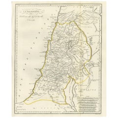
Original Antique Map of Palestine, 1800
View Similar Items


Want more images or videos?
Request additional images or videos from the seller
1 of 5
Auction endedBrowse Current Auctions
Original Antique Map of Palestine, 1800
About the Item
- Dimensions:Height: 15.56 in (39.5 cm)Width: 12.8 in (32.5 cm)Depth: 0.02 in (0.5 mm)
- Materials and Techniques:
- Period:
- Date of Manufacture:1800
- Condition:General age-related toning. Original folding lines. Minor wear, blank verso. Please study image carefully.
- Seller Location:Langweer, NL
- Reference Number:Seller: BG-12359-311stDibs: LU3054320941652
About the Seller
5.0
Platinum Seller
These expertly vetted sellers are 1stDibs' most experienced sellers and are rated highest by our customers.
Established in 2009
1stDibs seller since 2017
1,933 sales on 1stDibs
More From This SellerView All
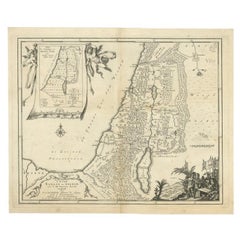
- Antique Map of Biblical Palestine with Inset of Israel's 12 Tribes, 1758Located in Langweer, NLAntique map titled 'De IIIde Landkaart 't land Kanaan en Gilead onder de XII stammen Israëls verdeelt.' Map of biblical Palestine. Inset map of the land of Israel divided in 12 tribes...Category
Antique 18th Century Maps
MaterialsPaper
- Original Antique Map of AfricaLocated in Langweer, NLAntique map titled 'Afrika'. Original antique map of Africa, drawn by Van Beusekom. Published by 'Seyffardt's Boekhandel' in Amsterdam, circa 1870.Category
Antique Late 19th Century Maps
MaterialsPaper
 $298 Sale Price20% Off
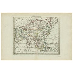
 - Original Antique Map of AsiaLocated in Langweer, NLAntique map titled 'Asien'. Original old map of Asia. Published in Berlin by Simon Schropp et Comp, 1819.Category
Antique Early 19th Century Maps
MaterialsPaper
- Antique Map of Asia by A. Blondeau, circa 1800Located in Langweer, NLThis is a fine circa 1800 map of Asia by Alexandre Blondeau. It covers the entire continent from Africa and the Mediterranean east to the Bering Sea and south as far as Java and New ...Category
Antique Early 19th Century Maps
MaterialsPaper
 $215 Sale Price30% Off
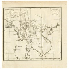
 - Antique Map of the Burmese Empire by Symes, '1800'Located in Langweer, NLAntique map titled 'Empire Birman d'après une carte'. Map of the Burmese Empire. This map originates from 'Relation de l'Ambassade Anglaise, envoyée en 1795 dans le Royaume d'Ava, ou...Category
Antique Early 19th Century Maps
MaterialsPaper
- Original Antique Map of Northern IndiaBy Jakob van der SchleyLocated in Langweer, NLAntique map titled 'Carte de l'Indoustan (..) - Kaart van Hindoestan (..)'. Original antique map of northern India. This map originates from 'His...Category
Antique Mid-18th Century Maps
MaterialsPaper


You May Also Like
- Antique Map of Principality of MonacoBy Antonio Vallardi EditoreLocated in Alessandria, PiemonteST/619 - "Old Geographical Atlas of Italy - Topographic map of ex-Principality of Monaco" - ediz Vallardi - Milano - A somewhat special edition ---Category
Antique Late 19th Century Italian Other Prints
MaterialsPaper
 $228 Sale Price74% Off
 - Large Antique 1859 Map of North AmericaLocated in Sag Harbor, NYThis Map was made by Augustus Mitchell in 1859 It is in amazing condition for being 163 years old. This price is for the rolled up easy to ship version of this piece. I will be Frami...Category
Antique Mid-19th Century American Maps
MaterialsCanvas, Paper

- Antique Map of Italy by Andriveau-Goujon, 1843By Andriveau-GoujonLocated in New York, NYAntique Map of Italy by Andriveau-Goujon, 1843. Map of Italy in two parts by Andriveau-Goujon for the Library of Prince Carini at Palazzo Carini i...Category
Antique 1840s French Maps
MaterialsLinen, Paper
 $3,350 / set
 - "San Francisco, Upper California” 1851 Antique Map of San FranciscoLocated in Colorado Springs, COThis is a pictorial lettersheet view of the city and harbor of San Francisco. This lithograph was printed on grey wove paper, across a double sheet, by famed lithographers Britton & ...Category
Antique 1850s American Prints
MaterialsPaper
 $1,200 Sale Price20% Off
 - Antique 18th Century Map of the Province of Pensilvania 'Pennsylvania State'Located in Philadelphia, PAA fine antique of the colony of Pennsylvania. Noted at the top of the sheet as a 'Map of the province of Pensilvania'. This undated and anonymous map is thought to be from the Gentleman's Magazine, London, circa 1775, although the general appearance could date it to the 1760's. The southern boundary reflects the Mason-Dixon survey (1768), the western boundary is placed just west of Pittsburgh, and the northern boundary is not marked. The map has a number of reference points that likely refer to companion text and appear to be connected to boundaries. The western and southern boundaries are marked Q, R, S, for example. A diagonal line runs from the Susquehanna R to the Lake Erie P. A broken line marked by many letters A, B, N, O, etc., appears in the east. There are no latitude or longitude markings, blank verso. Framed in a shaped contemporary gilt wooden frame and matted under a cream colored matte. Bearing an old Graham Arader Gallery...Category
Antique 18th Century British American Colonial Maps
MaterialsPaper
- Map of the Republic of GenoaLocated in New York, NYFramed antique hand-coloured map of the Republic of Genoa including the duchies of Mantua, Modena, and Parma. Europe, late 18th century. Dimension: 25...Category
Antique Late 18th Century European Maps

