Items Similar to Original Map of the East Indies Including Sumatra, Java, Borneo & Malaysia, 1747


Want more images or videos?
Request additional images or videos from the seller
1 of 5
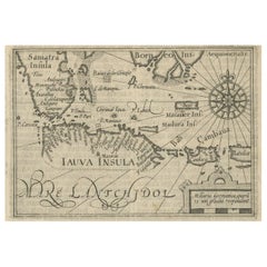
Original Map of the East Indies Including Sumatra, Java, Borneo & Malaysia, 1747
About the Item
Antique map titled 'Carte des Isles Java, Sumatra, Borneo (..) - Kaart van de Eilanden van Iava, Sumatra, Borneo (..)'.
Map of the East Indies including Sumatra, Java, Borneo and Malaysia. This map originates from a Dutch edition of 'Histoire générale des voyages' by Antoine-François Prévost.
Artists and Engravers: Engraved by J. van Schley. Jakob van der Schley (Amsterdam, 1715-1779) was a Dutch draughtsman and engraver, who studied under Bernard Picart, and whose style he subsequently copied.
Condition:
Good, general age-related toning. Image trimmed, minor wear. Original folding lines, blank verso. Please study image carefully.
- Dimensions:Height: 9.65 in (24.5 cm)Width: 13 in (33 cm)Depth: 0 in (0.02 mm)
- Materials and Techniques:
- Period:1740-1749
- Date of Manufacture:1747
- Condition:Wear consistent with age and use.
- Seller Location:Langweer, NL
- Reference Number:
About the Seller
5.0
Platinum Seller
These expertly vetted sellers are 1stDibs' most experienced sellers and are rated highest by our customers.
Established in 2009
1stDibs seller since 2017
1,929 sales on 1stDibs
Typical response time: <1 hour
- ShippingRetrieving quote...Ships From: Langweer, Netherlands
- Return PolicyA return for this item may be initiated within 14 days of delivery.
More From This SellerView All
- Antique Map of the Sunda Islands Including Sumatra, Java, and Borneo, 1705Located in Langweer, NLTitle: “Antique Map of the Sunda Islands Including Sumatra, Java, and Borneo” This print is a beautifully detailed and relatively rare map of Western Indonesia, encompassing the reg...Category
Antique Early 1700s Maps
MaterialsPaper
- Antique Map of Singapore, Malaysia, Borneo, Sumatra and Java (Indonesia), 1739Located in Langweer, NL"Antique map titled 'Nieuwe kaart van de Sundasche Eilanden als Borneo, Sumatra en Groot Iava & c'. Detailed map of Southeast Asia, extending from the tip of Cambodia to Java. This m...Category
Antique 18th Century Maps
MaterialsPaper
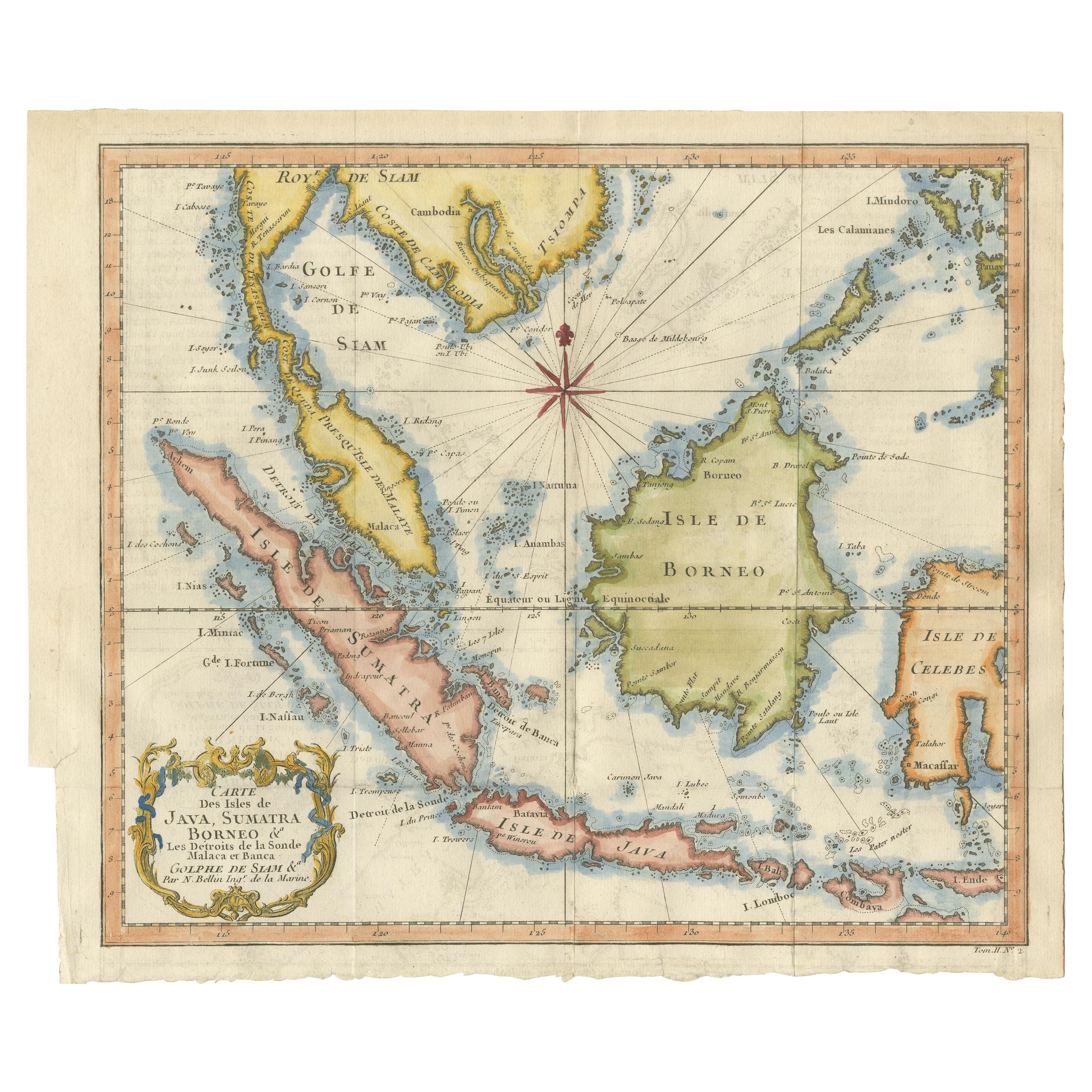
- Antique Engraving of Malaysia, Brunei, Singapore, Java, Borneo, Sumatra, c.1750Located in Langweer, NLNice decorative and detailed map from the Gulf of Siam and Mindoro to Timo, Java and Sumatra Borneo and Roy de Siam. Large compass rose and nice cartouche. Title: Carte des Isles ...Category
Antique Mid-18th Century Maps
MaterialsPaper
- Antique Map of the Sunda Islands Sumatra, Java, Malay Peninsula & Borneo (1739)By Isaak TirionLocated in Langweer, NLAntique map titled 'Nieuwe kaart van de Sundasche Eilanden als Borneo, Sumatra en Groot Iava & c'. Detailed map of the Sunda Islands, Southeast Asia, extending from the tip of Cambod...Category
Antique Mid-18th Century Maps
MaterialsPaper
- Rare Small Map of Sumatra, Java, Borneo, Macassar, Madura, Bali, 1614Located in Langweer, NLOne of the first maps of the Indonesia islands of Java, Bali, Sumbawa etc. in early days of the Dutch Indies. Also showing Banten, Jakarta (Jacatra), Indr...Category
Antique Early 17th Century Maps
MaterialsPaper
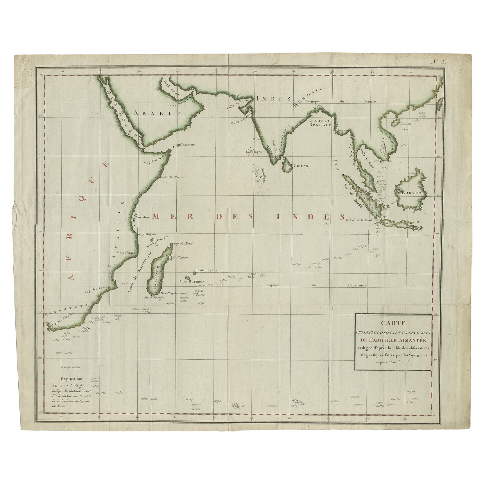
- Old Map of Indian Ocean & Sumatra, Java, Borneo, India, Arabia, Africa, c.1783Located in Langweer, NLAntique map titled 'Carte des Declinaisons et Inclinaisons de L'Aiguille Aimantée redigée d'après la table des observations Magnetiques faites par les Voyageurs depuis l'Année 1775'....Category
Antique 1780s Maps
MaterialsPaper


You May Also Like
- Large Original Antique Map of Java and Borneo, Fullarton, C.1870Located in St Annes, LancashireGreat map of Java and Borneo Wonderful figurative borders From the celebrated Royal Illustrated Atlas Lithograph. Original color. Published by Fullarton, Edinburgh. C.1870 Unfr...Category
Antique 1870s Scottish Maps
MaterialsPaper
- Large Original Vintage Map of The Pacific Islands Including HawaiiLocated in St Annes, LancashireGreat map of The Pacific Islands Unframed Original color By John Bartholomew and Co. Edinburgh Geographical Institute Published, circa 1...Category
Vintage 1920s British Maps
MaterialsPaper
- Large Original Antique Map of The West Indies by Sidney Hall, 1847Located in St Annes, LancashireGreat map of The West Indies Drawn and engraved by Sidney Hall Steel engraving Original colour outline Published by A & C Black. 1847 Unframed Free shipping.Category
Antique 1840s Scottish Maps
MaterialsPaper
- Seminal guide to the East and West Indies, with 42 coloured maps and platesBy Jan Huygen van LinschotenLocated in ZWIJNDRECHT, NLSeminal guide to the East and West Indies, with 42 double-page and folding plates, including 6 maps, all engravings beautifully coloured by a contemporary hand LINSCHOTEN, Jan Huygh...Category
Antique Early 17th Century Dutch Dutch Colonial Books
MaterialsPaper
- Original Antique Map of South East Asia, Arrowsmith, 1820Located in St Annes, LancashireGreat map of South East Asia Drawn under the direction of Arrowsmith Copper-plate engraving Published by Longman, Hurst, Rees, Orme and Brown, 1820 Unframed.Category
Antique 1820s English Maps
MaterialsPaper
- East German MapBy VEB Hermann HaackLocated in Baltimore, MDA brilliantly colourful map of the Leipzig, Karl Marx Stadt and Dresden area in the former German Democratic Republic by VEB Hermann Haack of Gotha.Category
Vintage 1970s German Maps


