Items Similar to Original Old Copper Engraved Map of the Region of Albi, Southern France, 1663

Want more images or videos?
Request additional images or videos from the seller
1 of 5
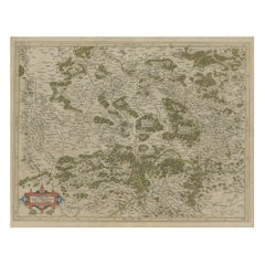
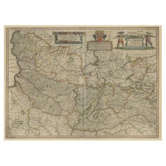
Original Old Copper Engraved Map of the Region of Albi, Southern France, 1663
About the Item
Antique map titled 'Carte du Diocese d'Alby'.
Original antique map of the region of Albi in Southern France. This map originates from 'Topographia Galliae dat is eene algemeene en bysondere naukeurige lant en plaets beschrivinge (..)' published 1663.
Artists and Engravers: Caspar Merian (1627-1686) was one of the most important German topographical engravers and publishers in the Baroque period. He was the son and pupil of his father Matthaeus Merian the elder (1593-1650) and his first wife Maria Magdalena - de Bry. His brother was Matthaeus the younger. The artist Maria Sibylla Merian (1647-1717) was his half sister from his fathers second wife Johanna Sibylla Catharina.
Condition: Good, general age-related toning. Original folding line, minor wear. Blank verso. Please study image carefully.
- Dimensions:Height: 12.6 in (32 cm)Width: 15.16 in (38.5 cm)Depth: 0 in (0.02 mm)
- Materials and Techniques:
- Period:1660-1669
- Date of Manufacture:1663
- Condition:
- Seller Location:Langweer, NL
- Reference Number:
About the Seller
5.0
Platinum Seller
These expertly vetted sellers are 1stDibs' most experienced sellers and are rated highest by our customers.
Established in 2009
1stDibs seller since 2017
1,916 sales on 1stDibs
Typical response time: <1 hour
- ShippingRetrieving quote...Ships From: Langweer, Netherlands
- Return PolicyA return for this item may be initiated within 14 days of delivery.
More From This SellerView All
- Detailed Original Old Map of the Southern Region of the Kingdom of Algiers 1773Located in Langweer, NLAntique map titled 'Kaart van het Zuidelyk Gedeelte van het Ryk Algiers'. Old map of the southern region of the Kingdom of Algiers, Algeria. Originates from the first Dutch edito...Category
Antique 18th Century Maps
MaterialsPaper
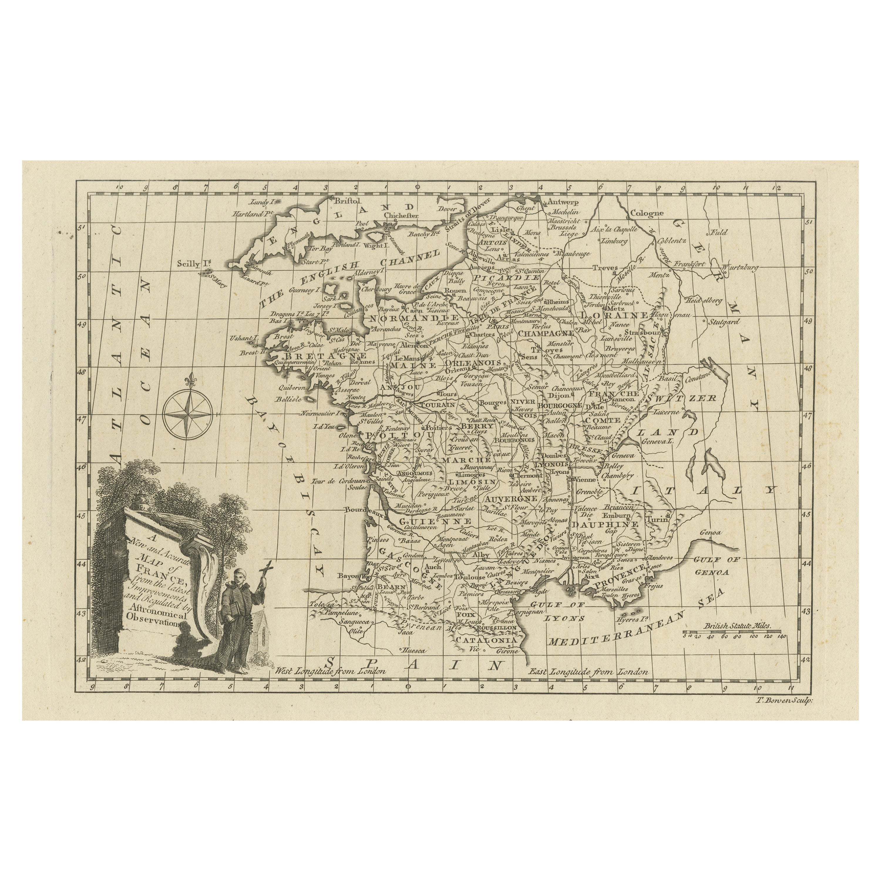
- Original Copper Engraved Map of FranceLocated in Langweer, NLAntique map titled 'New and Accurate Map of France from the latest improvements'. Original copper engraved map of France. Engraved by T. Bowen, published circa 1771.Category
Antique Late 18th Century Maps
MaterialsPaper
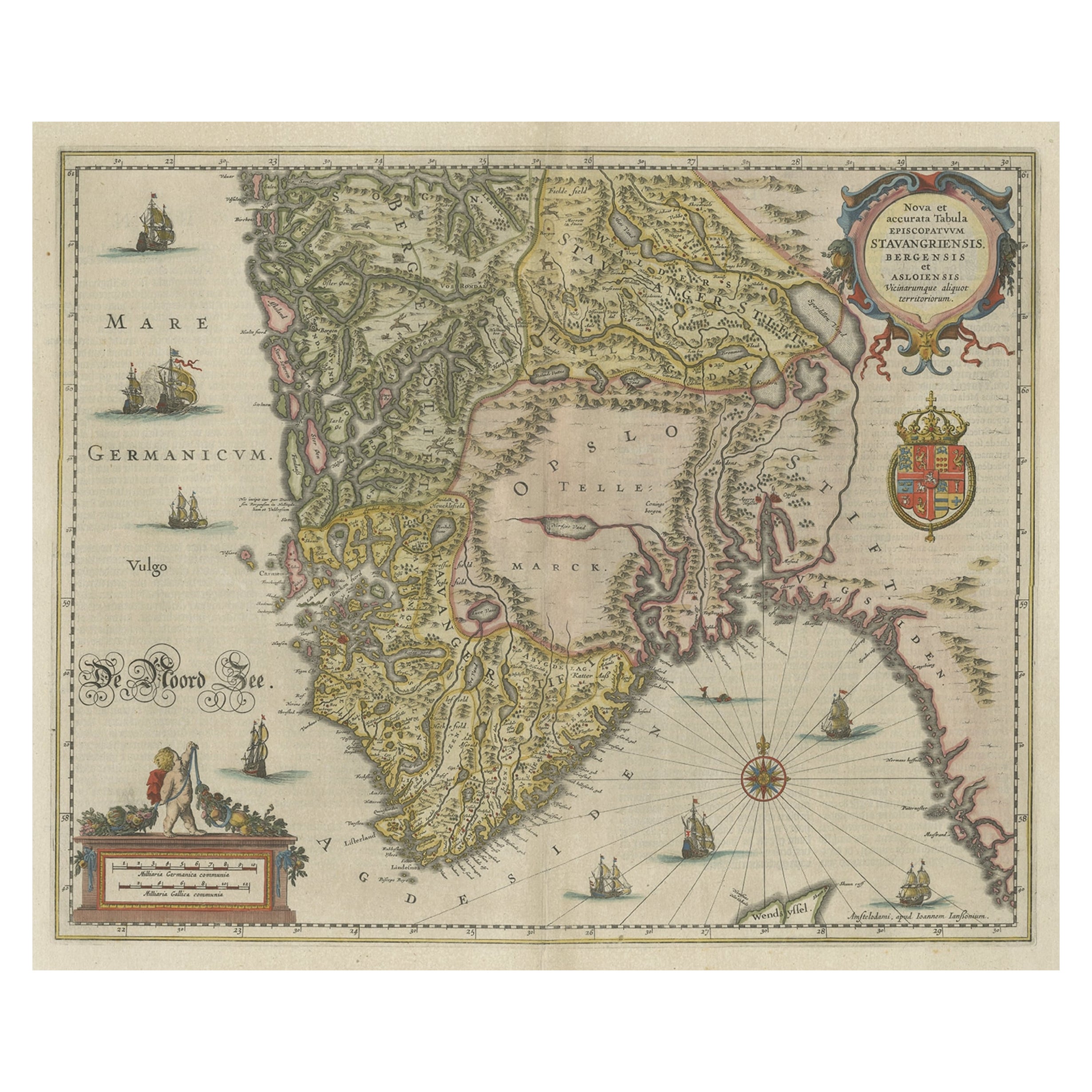
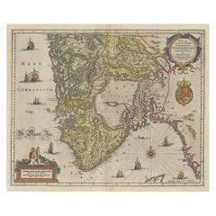
- Old Map of The Southern Part of Norway, Covering the Region Around Bergen, c1650Located in Langweer, NLAntique map titled 'Nova et Accurata Tabula Episcopatuum Stavangriensis et Asloiensis'. Old map of the southern part of Norway, it covers the region around Bergen. Decorated with...Category
Antique 1650s Maps
MaterialsPaper
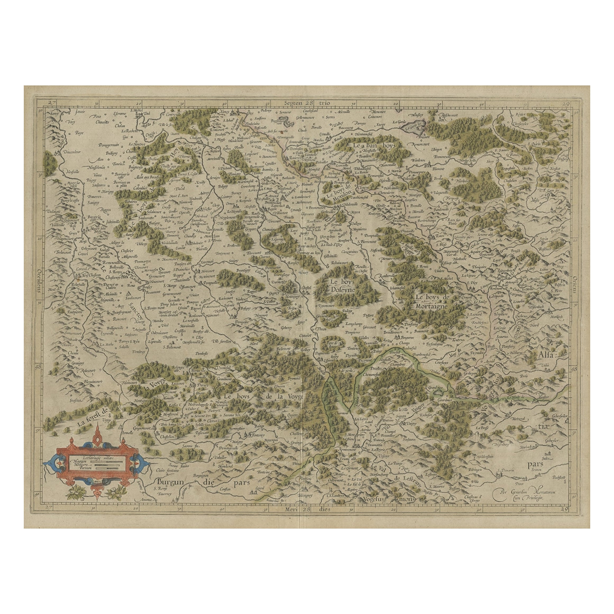
- Antique Map of the Southern Lorraine Region by Mercator, c.1625By Gerard MercatorLocated in Langweer, NLAntique map titled 'Lotharingiae Ducatus'. Old map of the southern portion of the Lorraine region, France. Lorraine is a cultural and historical region in north-eastern France, now l...Category
Antique 17th Century Maps
MaterialsPaper
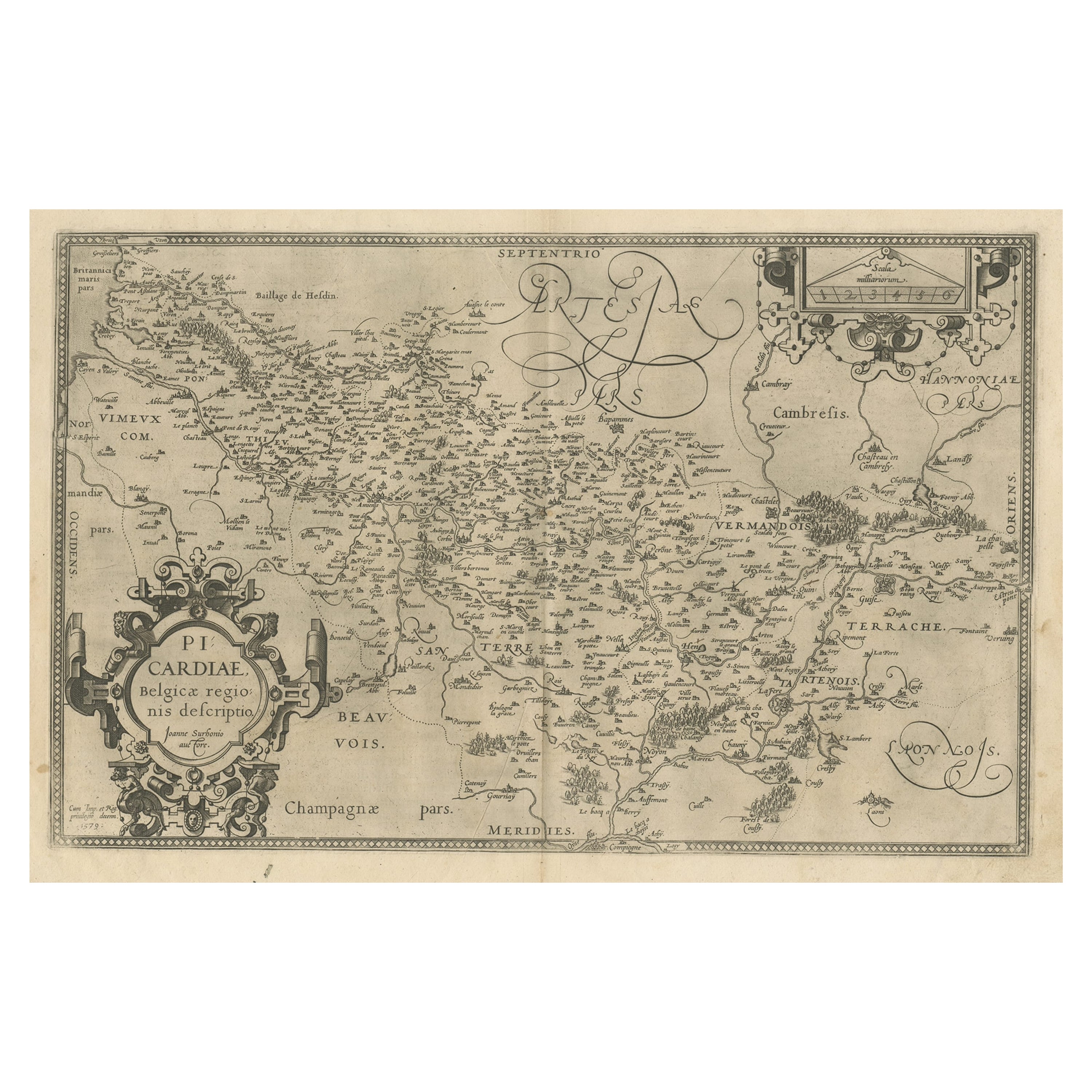
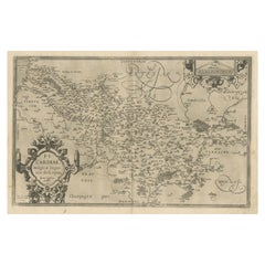
- Original Antique Map of the Region of Picardy, France, ca.1602Located in Langweer, NLAntique map titled 'Picardiae Belgicae regionis descriptio'. Original antique map of the region of Picardy, France. Superb example of the decorative style of Ortelius and filled ...Category
Antique Early 1600s Maps
MaterialsPaper
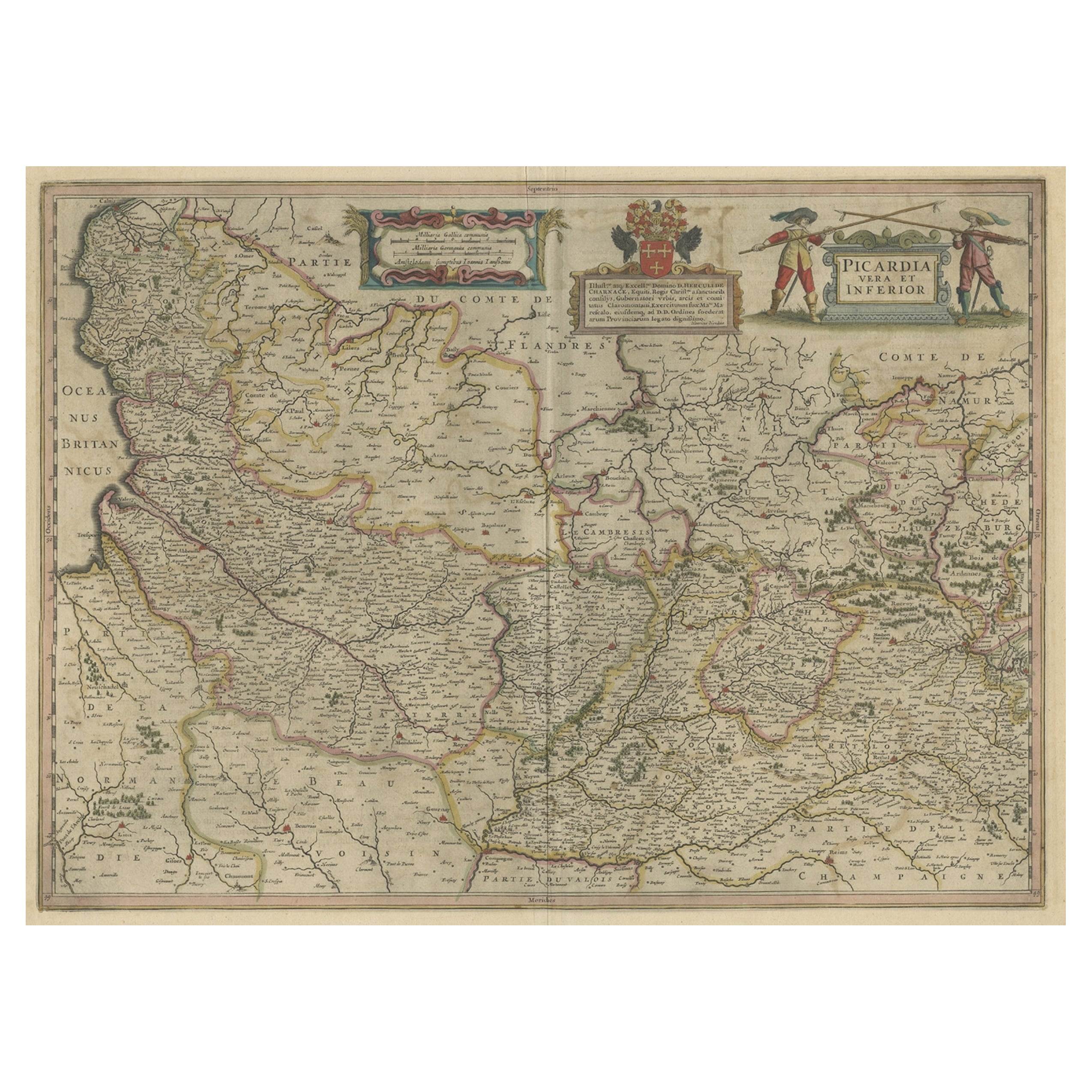
- Detailed Original Antique Map of the Picardy Region of France, 1657Located in Langweer, NLAntique map of France titled 'Picardia vera et inferior'. Detailed map of the Picardy region of France. This map originates from 'Atlas Novus, Sive Theatrum Orbis Orbis Terrarum:...Category
Antique 1650s Maps
MaterialsPaper


You May Also Like
- Original Antique Map of The Netherlands, Engraved by Barlow, Dated 1807Located in St Annes, LancashireGreat map of Netherlands Copper-plate engraving by Barlow Published by Brightly & Kinnersly, Bungay, Suffolk. Dated 1807 Unframed.Category
Antique Early 1800s English Maps
MaterialsPaper
- Original Antique Map of Sweden, Engraved by Barlow, 1806Located in St Annes, LancashireGreat map of Sweden Copper-plate engraving by Barlow Published by Brightly & Kinnersly, Bungay, Suffolk. 1806 Unframed.Category
Antique Early 1800s English Maps
MaterialsPaper
- The Normandy Region of France: A 17th C. Hand-colored Map by Sanson and JaillotBy Nicolas SansonLocated in Alamo, CAThis large hand-colored map entitled "Le Duché et Gouvernement de Normandie divisée en Haute et Basse Normandie en divers Pays; et par evêchez, avec le Gouvernement General du Havre ...Category
Antique 1690s French Maps
MaterialsPaper
- Original Antique Map of Switzerland, Engraved By Barlow, Dated 1807Located in St Annes, LancashireGreat map of Switzerland Copper-plate engraving by Barlow Published by Brightly & Kinnersly, Bungay, Suffolk. Dated 1807 Unframed.Category
Antique Early 1800s English Maps
MaterialsPaper
- Original Antique Map of Spain and Portugal, Engraved By Barlow, 1806Located in St Annes, LancashireGreat map of Spain And Portugal Copper-plate engraving by Barlow Published by Brightly & Kinnersly, Bungay, Suffolk. 1806 Unframed.Category
Antique Early 1800s English Maps
MaterialsPaper
- Old Nautical Map of CorsicaLocated in Alessandria, PiemonteST/556/1 - Old map of Corsica isle, surveyed by Captain Hell, of the French Royal Navy in 1824, engraved and published on 1874, with additions and corre...Category
Antique Early 19th Century English Other Prints
MaterialsPaper


Recently Viewed
View AllMore Ways To Browse
Engraved Copper
Antique Copper Old
Topographical Map
Copper Map
Antique Topographic Maps
Maria Magdalena
Antique Map Of The United States
Antique Maps Of The United States
Antique African American
African American Antique
Antique Furniture East London
Antique Eastern European Furniture
Vintage Map Of The United States
Antique House Plans
Antique Metal Window
Antique Metal Windows
Antique Furniture Rollers
Antiques Compasses