Items Similar to Philips Map of the Seat of War 1854 – Black Sea, Turkey & Russia Antique Map
Want more images or videos?
Request additional images or videos from the seller
1 of 10
Philips Map of the Seat of War 1854 – Black Sea, Turkey & Russia Antique Map
$735.19
£546.56
€620
CA$1,018.84
A$1,135.82
CHF 592.37
MX$13,734.64
NOK 7,446.44
SEK 7,045.82
DKK 4,720.22
About the Item
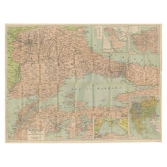
Philips Map of the Seat of War 1854 – Black Sea, Turkey & Russia Antique Map
This folding map, titled “Philips’ Map of the Seat of War”, was published in Liverpool by George Philip & Son in 1854, at the outbreak of the Crimean War (1853–1856). It was produced for the British public eager to follow developments in a conflict that involved Britain, France, the Ottoman Empire, and Sardinia against Russia.
The map focuses on the Black Sea region, the heart of the conflict. It details the frontier provinces of Turkey, Russia, and Austria, including Moldavia, Wallachia, Transylvania, and the Crimea. Towns, fortresses, rivers, and mountain ranges are finely engraved, while borders are highlighted in hand color. The Black Sea is rendered with bold horizontal shading, drawing attention to its strategic significance as the theater of naval operations.
The map’s coverage extends from Vienna and southern Poland in the west to the Caucasus, Armenia, and Persia in the east. Constantinople (Istanbul), the Dardanelles, Sevastopol, Odessa, Trebizond, and other major centers of military interest are clearly shown.
This map is not only a geographical document but also a piece of political propaganda, designed to help the British public visualize the war front. Its practical folding format suggests it was intended for both educational and popular use.
Condition: Good. Original hand color with light age toning. Some spotting and fold wear consistent with age. No Linen backing.
Framing tips: A strong candidate for float-mounting to showcase its linen panels and folding structure. A simple dark frame with cream mat would enhance the period feel while keeping the map’s vibrant hand coloring in focus.
Technique: Engraving with original hand color, dissected and mounted on linen
Maker: George Philip & Son, Liverpool, 1854
Collector’s note: George Philip & Son was one of the leading British map publishers of the mid-19th century. Their “Seat of War” maps, produced during the Crimean War, are highly sought after today as historical artifacts linking Victorian cartography with contemporary world events. This 1854 edition represents one of the earliest printed maps reflecting the unfolding conflict.
- Dimensions:Height: 18.31 in (46.5 cm)Width: 25.79 in (65.5 cm)Depth: 0 in (0.02 mm)
- Materials and Techniques:
- Place of Origin:
- Period:
- Date of Manufacture:1854
- Condition:Condition: Good. Original hand color with light age toning. Some spotting and fold wear consistent with age. No Linen backing.
- Seller Location:Langweer, NL
- Reference Number:Seller: BG-13846-11stDibs: LU3054346393162
About the Seller
5.0
Recognized Seller
These prestigious sellers are industry leaders and represent the highest echelon for item quality and design.
Platinum Seller
Premium sellers with a 4.7+ rating and 24-hour response times
Established in 2009
1stDibs seller since 2017
2,589 sales on 1stDibs
Typical response time: <1 hour
- ShippingRetrieving quote...Shipping from: Langweer, Netherlands
- Return Policy
Authenticity Guarantee
In the unlikely event there’s an issue with an item’s authenticity, contact us within 1 year for a full refund. DetailsMoney-Back Guarantee
If your item is not as described, is damaged in transit, or does not arrive, contact us within 7 days for a full refund. Details24-Hour Cancellation
You have a 24-hour grace period in which to reconsider your purchase, with no questions asked.Vetted Professional Sellers
Our world-class sellers must adhere to strict standards for service and quality, maintaining the integrity of our listings.Price-Match Guarantee
If you find that a seller listed the same item for a lower price elsewhere, we’ll match it.Trusted Global Delivery
Our best-in-class carrier network provides specialized shipping options worldwide, including custom delivery.More From This Seller
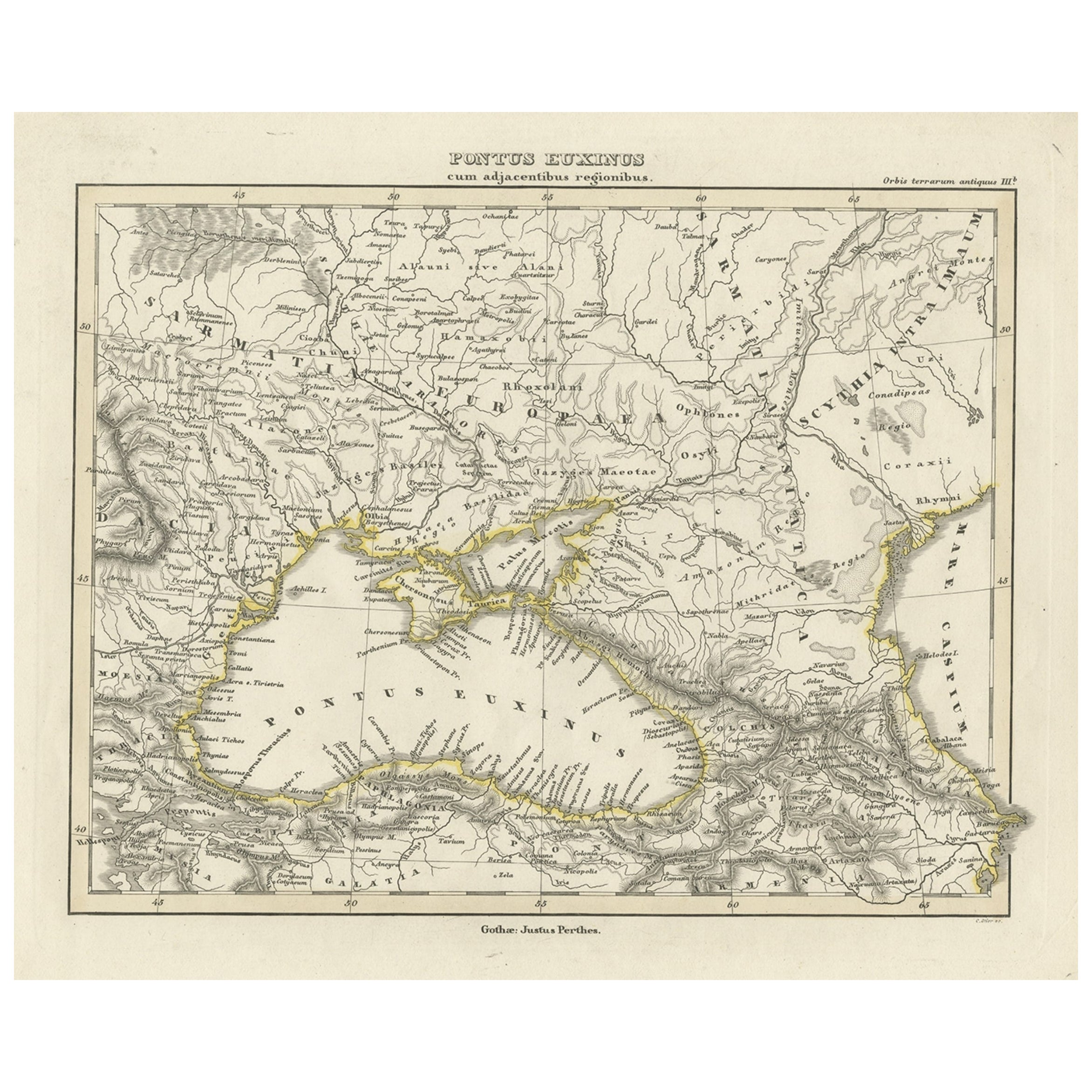
View AllAntique Map of the Black Sea by Perthes, 1848
Located in Langweer, NL
Antique map titled 'Pontus Euxinus'. Old map of the Black Sea and surroundings originating from 'Orbis Terrarum Antiquus in usum Scholarum'. Artists and Engravers: Published by Justu...
Category
Antique 19th Century Maps
Materials
Paper
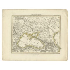
$93 Sale Price
20% Off
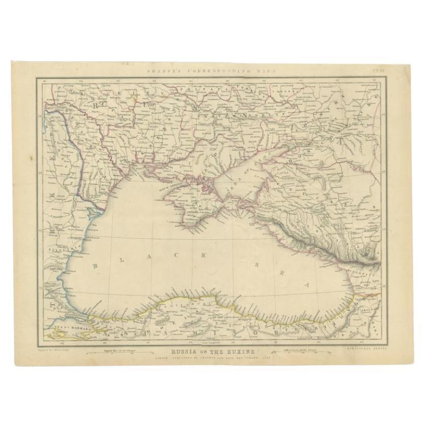
Antique Map of the Black Sea and Surroundings by Sharpe, 1849
Located in Langweer, NL
Antique map titled 'Russia on the Euxine'. Old map of the Black Sea and the surrounding (Russia). This map originates from 'Sharpe's Corresponding Atlas (..)' by J. Sharpe. Artists and Engravers: Published by Chapman and Hall...
Category
Antique 19th Century Maps
Materials
Paper

$90 Sale Price
20% Off
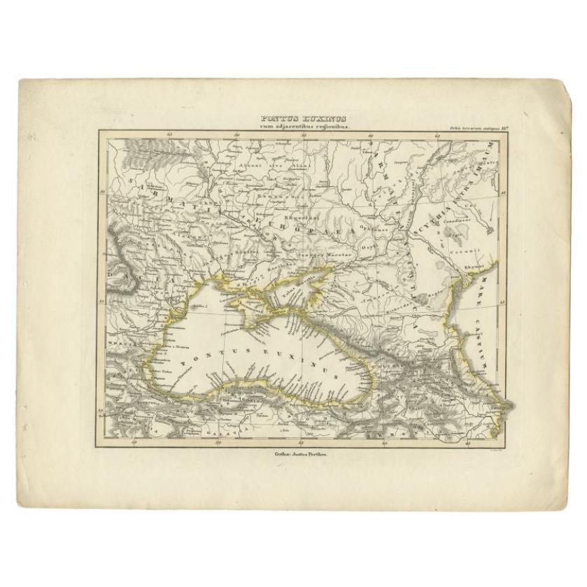
Old Map of the Black Sea, The Krim, Ukraine, Russia, etc in Historic Times, 1848
Located in Langweer, NL
Antique map titled 'Pontus Euxinus'. Old map of the black Sea and surroundings originating from 'Orbis Terrarum Antiquus in usum Scholarum'.
Artists and Engravers: Published by J...
Category
Antique 1840s Maps
Materials
Paper
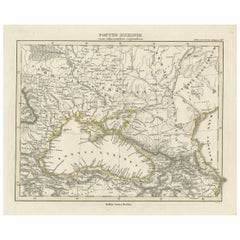
$227 Sale Price
20% Off
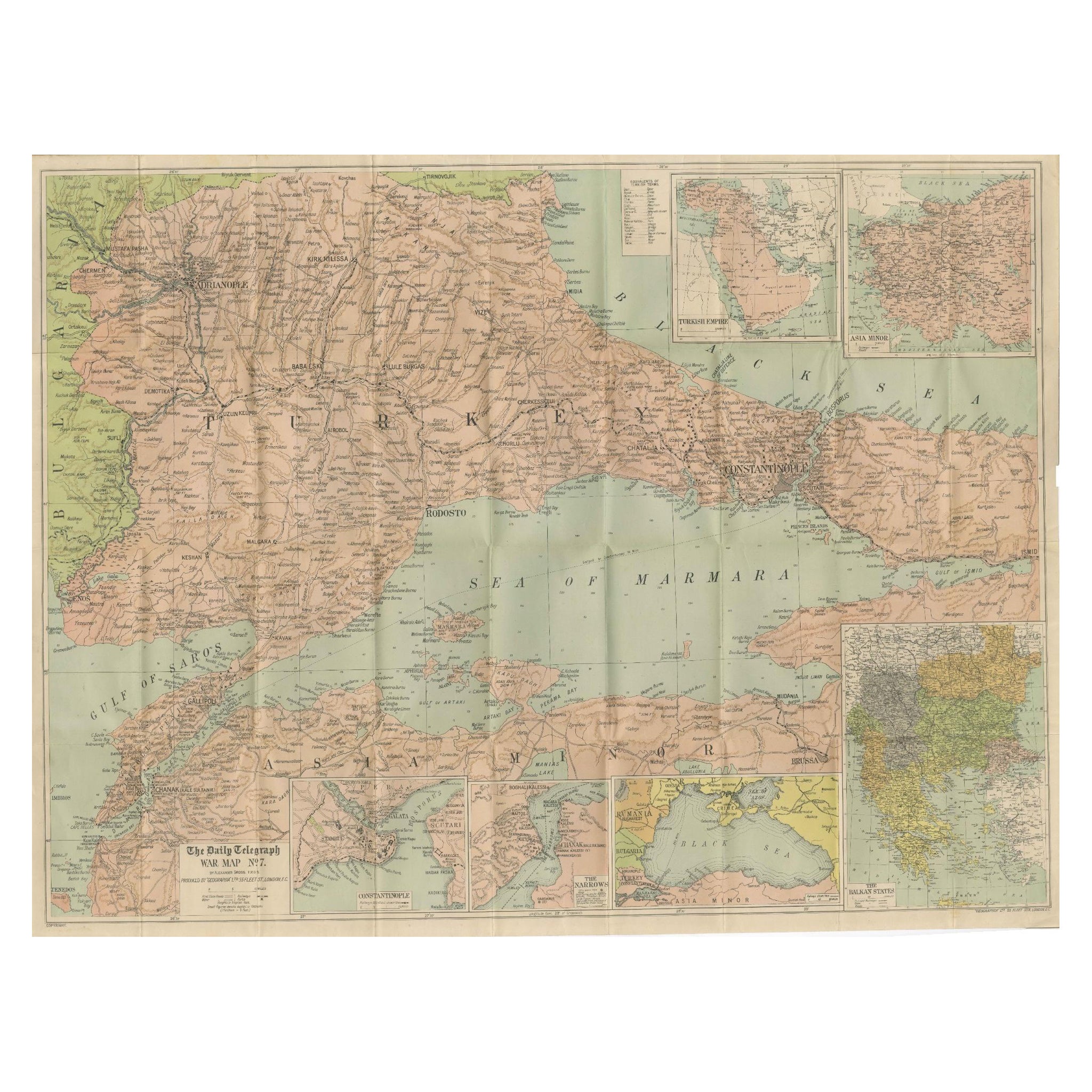
Daily Telegraph War Map 1877 – Ottoman Empire, Balkans & Constantinople Antique
Located in Langweer, NL
Daily Telegraph War Map 1877 – Ottoman Empire, Balkans & Constantinople Antique Map
This large lithographed folding map was published as War Map No. 7 by The Daily Telegraph, London...
Category
Antique 1870s English Maps
Materials
Paper
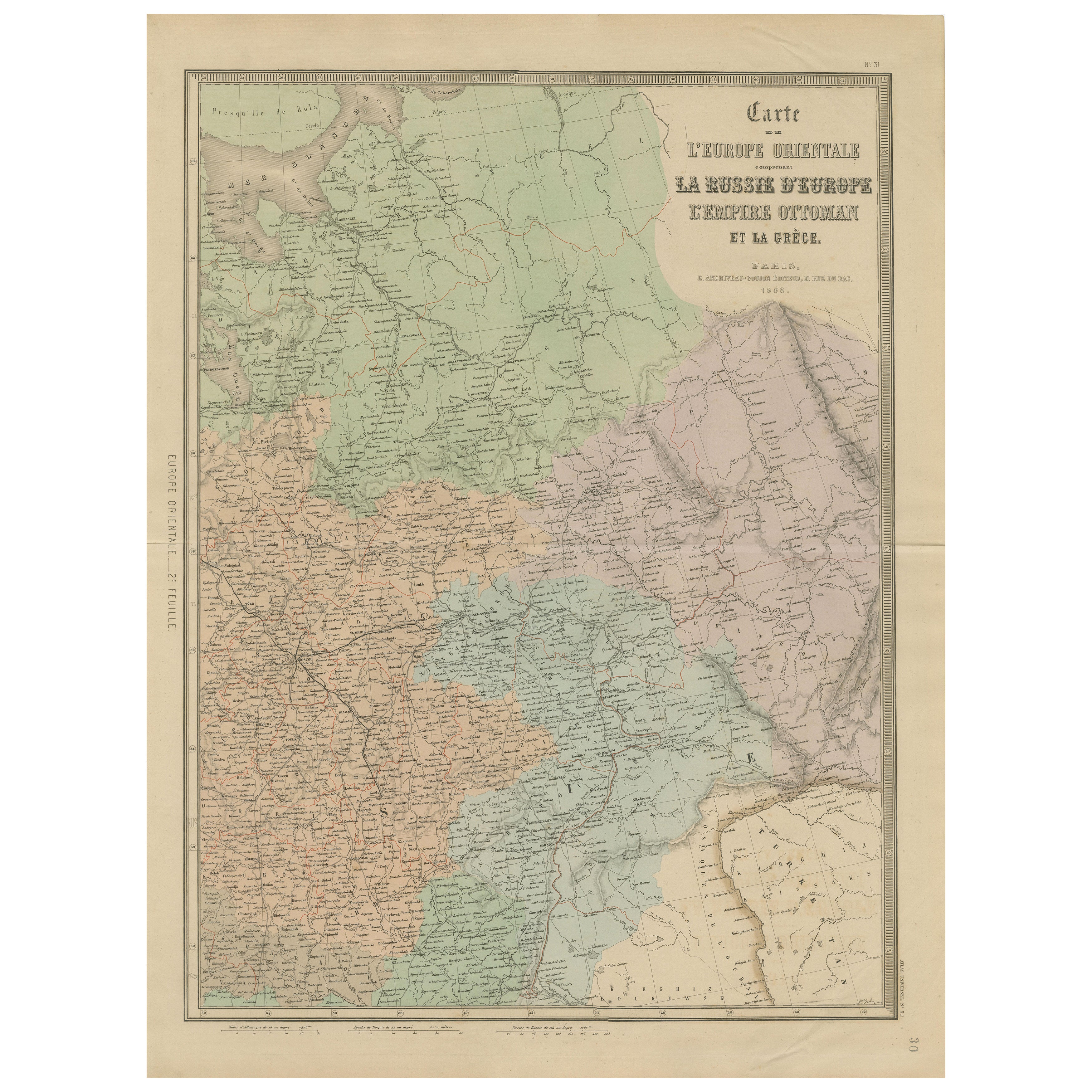
Antique Map of Eastern Europe – Russia, Ottoman Empire & Greece, 1868
Located in Langweer, NL
Antique Map of Eastern Europe – Russia, Ottoman Empire and Greece by Andriveau-Goujon, 1868
This detailed antique map titled “Carte de l’Europe Orientale, la Russie d’Europe, l’Empi...
Category
Antique Mid-19th Century French Maps
Materials
Paper
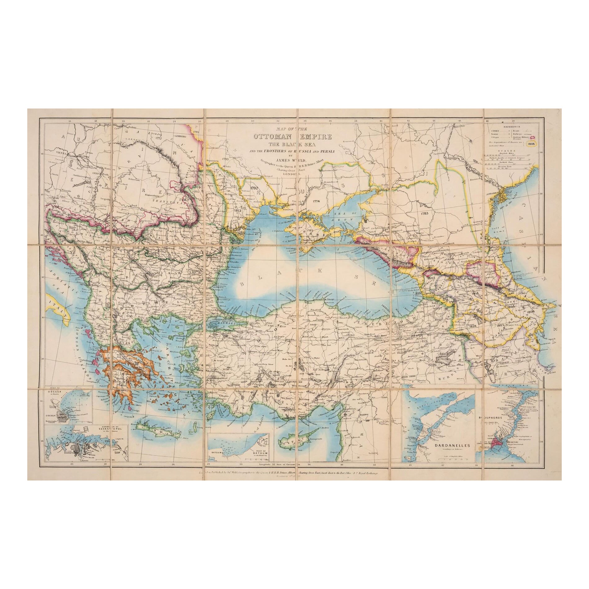
1853 Wyld Map of Turkey in Asia, the Balkans, and the Ottoman Empire
Located in Langweer, NL
James Wyld's 1853 Map of the Ottoman Empire and Adjacent Regions
James Wyld's 1853 map, "Map of the Ottoman Empire, The Black Sea and the Frontiers of Russia and Persia," offers a m...
Category
Antique 1850s English Maps
Materials
Paper

You May Also Like
1849 Map of "Europaische Russland", 'Meyer Map of European Russia', Ric. R017
Located in Norton, MA
1849 Map of
"Europaische Russland"
( Meyer Map of European Russia)
Ric.r017
A lovely map of European Russia dating to 1849 by Joseph Meyer. It covers the European portions of...
Category
Antique 19th Century Unknown Maps
Materials
Paper

Russia, Western and Southern Part. Century Atlas antique vintage map
Located in Melbourne, Victoria
'The Century Atlas. Russia, Western and Southern Part'
Original antique map, 1903.
Inset map tilted 'St Petersburg and Environs'.
Central fold as issued. Map name and number printe...
Category
Early 20th Century Victorian More Prints
Materials
Lithograph

1860 Large Map "Carte De La Siberie Russie D'asie, " Ric.R0001
Located in Norton, MA
Large 1860 map "Carte De La Siberie Russie D'Asie," R-0001
" Authentic" - 1860 map "Carte De La Siberie Russie D'Asie,"
Dimension: Paper: 68 cm W x 51 cm H ; Sight: 51cm W x 4...
Category
Antique 19th Century Unknown Maps
Materials
Paper

Large1852 Map "Russian Empire" Ric.r0011
Located in Norton, MA
Large
1852 map "Russian Empire"
George Phillips & Son 1852
Ric.r0011
Dimension: Paper: 67 cm W x 52 cm H ; Sight: 60cm W x 50 cm H
Condition: Good Condition with aged tonin...
Category
Antique 19th Century Unknown Maps
Materials
Paper

Russia in Europe with Poland and Finland. Century Atlas antique vintage map
Located in Melbourne, Victoria
'The Century Atlas. Russia in Europe with Poland and Finland'
Original antique map, 1903.
Central fold as issued. Map name and number printed on the reverse corners.
Sheet 40cm by ...
Category
Early 20th Century Victorian More Prints
Materials
Lithograph

Map of Eastern Roman Empire -Vintage Offset Print - Early 20th Century
Located in Roma, IT
This map of Eastern Roman Empire is a vintage offset print realized in the early 20th Century.
The state of preservation of the artwork is aged with dif...
Category
Early 20th Century Figurative Prints
Materials
Offset
