Items Similar to Spice Epicenter: Engraving of The Banda Islands in the Age of Exploration, 1753

Want more images or videos?
Request additional images or videos from the seller
1 of 7
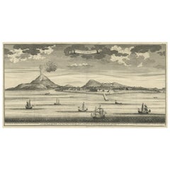
Spice Epicenter: Engraving of The Banda Islands in the Age of Exploration, 1753
About the Item
Title: Isles de Banda / Eylanden van Banda.
Maker: Van der Schley
Map of the Banda islands. Isles de Banda / Eylanden van Banda. Van der Schley based this chart on one contained in 'Het tvveede boeck, iournael oft dagh-register' by Jacob Cornelisz van Neck,.
This original antique engraving provides a detailed map of the Banda Islands, a group of ten small volcanic islands in the Banda Sea, central to the historic spice trade. The map showcases the islands' topography, with lush greenery and hilly terrain, hinting at the once-abundant presence of nutmeg and mace which were native to the islands.
Highlighted on the map is Fort Nassau, a significant Dutch fortress during the spice trade era, indicating its role in the defense and administration of the islands for controlling the valuable spice resources. The map's legend, probably in French, points to various landmarks, including the names of individual islands like Neira, and possibly mentions other smaller forts or points of interest.
The engraving's coloration is muted, with earthy tones for the land and a soft green for vegetation, suggesting the map's age and artistic style. The sea surrounding the islands is left mostly uncolored, drawing attention to the detailed coastline and the strategic positioning of the fortifications.
This map is not just a geographic depiction but also a historical document, revealing the extent of European colonization and its impact on the region. It would have been used for navigation and to assert territorial claims during a time when maps were as much political tools as they were aids to navigation.
The Banda Islands, historically known as the original and sole location for the production of nutmeg and mace, have a rich and tumultuous history marked by colonial ambitions and trade. The earliest European contact was made by the Portuguese in 1511, shortly after conquering Malacca, a major Asian trade hub. The Portuguese expedition, led by António de Abreu, used Malay pilots to navigate to Banda and established the first European contact with the islands in early 1512. The Bandanese were initially resistant to Portuguese attempts to control the trade and did not allow them to build a permanent fort or outpost on the islands.
The Dutch followed, with the Dutch East India Company (VOC) arriving in 1599, aiming to establish a monopoly over the lucrative spice trade. Dutch-Bandanese relations were fraught with tension and conflict. The Bandanese resisted Dutch control, leading to the Dutch conquest of the Banda Islands between 1609 and 1621, during which the Dutch used force and violence to subdue the local population. This resulted in the infamous Banda massacre, where thousands of Bandanese were killed or enslaved, and the remaining population was expelled. The VOC then established a plantation system on the islands, bringing in labor from other parts of Indonesia and beyond to work the nutmeg plantations, thus securing a Dutch monopoly on nutmeg production.
The Banda Islands were also the location of the first Dutch fort in the region, Fort Nassau, built to control the nutmeg trade. The islands changed hands several times through various treaties and conflicts between European powers, most notably in the Treaty of Breda in 1667 when the British exchanged the island of Run, part of the Banda archipelago, for New Amsterdam (now New York City) in North America with the Dutch.
Today, the Banda Islands are recognized for their rich biodiversity, both on land and in the surrounding Coral Triangle, which is renowned for its coral reefs and marine life diversity. The islands are also culturally significant, with traditions such as the Cakalele dance and the Kora-Kora boat races reflecting the islands' history and heritage. The Banda Islands' colonial buildings, forts, and remnants of the plantation system are a testament to their historical importance as a center of spice trade and colonial exploitation.
- Dimensions:Height: 11.03 in (28 cm)Width: 11.62 in (29.5 cm)Depth: 0 in (0.02 mm)
- Materials and Techniques:Paper,Engraved
- Period:1750-1759
- Date of Manufacture:circa 1753
- Condition:Very good .A few flattened folding lines. Later Hand-Coloring.
- Seller Location:Langweer, NL
- Reference Number:Seller: BG-13268-31stDibs: LU3054337747582
About the Seller
5.0
Recognized Seller
These prestigious sellers are industry leaders and represent the highest echelon for item quality and design.
Gold Seller
Premium sellers maintaining a 4.3+ rating and 24-hour response times
Established in 2009
1stDibs seller since 2017
2,452 sales on 1stDibs
Typical response time: <1 hour
- ShippingRetrieving quote...Shipping from: Langweer, Netherlands
- Return Policy
Authenticity Guarantee
In the unlikely event there’s an issue with an item’s authenticity, contact us within 1 year for a full refund. DetailsMoney-Back Guarantee
If your item is not as described, is damaged in transit, or does not arrive, contact us within 7 days for a full refund. Details24-Hour Cancellation
You have a 24-hour grace period in which to reconsider your purchase, with no questions asked.Vetted Professional Sellers
Our world-class sellers must adhere to strict standards for service and quality, maintaining the integrity of our listings.Price-Match Guarantee
If you find that a seller listed the same item for a lower price elsewhere, we’ll match it.Trusted Global Delivery
Our best-in-class carrier network provides specialized shipping options worldwide, including custom delivery.More From This Seller
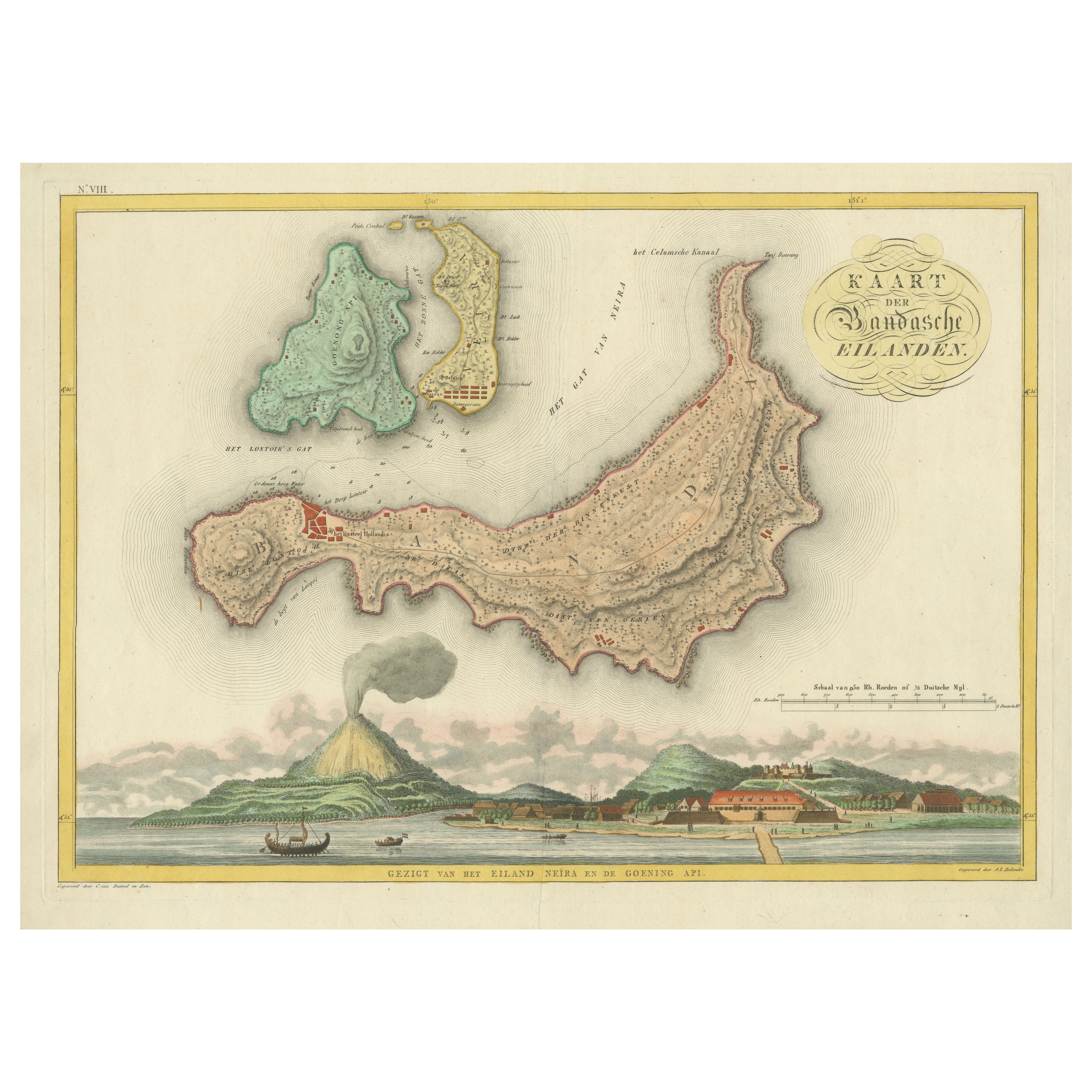
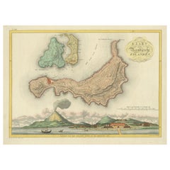
View AllColonial Cartography: The Banda Islands - the Epicenter of the Spice Trade, 1818
Located in Langweer, NL
Antique map titled 'Kaart der Bandasche Eilanden' with a view titled 'Gezigt van het Eiland Neira en de Goening Api'. Rare and attractive map of the Banda Islands with a large view of Banda Neira and Gunung Api. One of 12 maps from ‘Atlas van Overzeesche bezittingen’ (Atlas of Oversea Possessions) by J.S. van den Bosch. J.S. van den Bosch (1780 – 1844), Major General, Knight of the 3rd Class of the Military William Order.
It is a rare and visually appealing representation of the Banda Islands, a group of ten small volcanic islands in the Banda Sea, part of present-day Indonesia.
The map is one of twelve from the “Atlas van Overzeesche bezittingen” (Atlas of Overseas Possessions) by J.S. van den Bosch, who was a Major General and a Knight of the Military William Order. Johannes van den Bosch, who lived from 1780 to 1844, had a significant military and administrative career, including serving as Governor-General of the Dutch East Indies. His works and collections are reflective of the Dutch colonial interest and administration in the region.
The Banda Islands, depicted in this map, are particularly famous for being the sole source of nutmeg and mace before the mid-19th century. Nutmeg was highly valued in European cuisine, as a preservative, and as a medicine. The monopoly on these spices made the Banda Islands extremely important during the age of spice trade, which also led to intense colonial competition and conflict, notably between the Dutch and the British.
The map itself provides a detailed topographical representation of the Banda Islands, possibly with depth soundings and navigational hazards indicated, which would have been essential information for the ships of the Dutch East India Company and other seafarers. The large view of Banda Neira and Gunung Api (literally "Fire Mountain...
Category
Antique Early 19th Century Maps
Materials
Paper
$784 Sale Price
20% Off
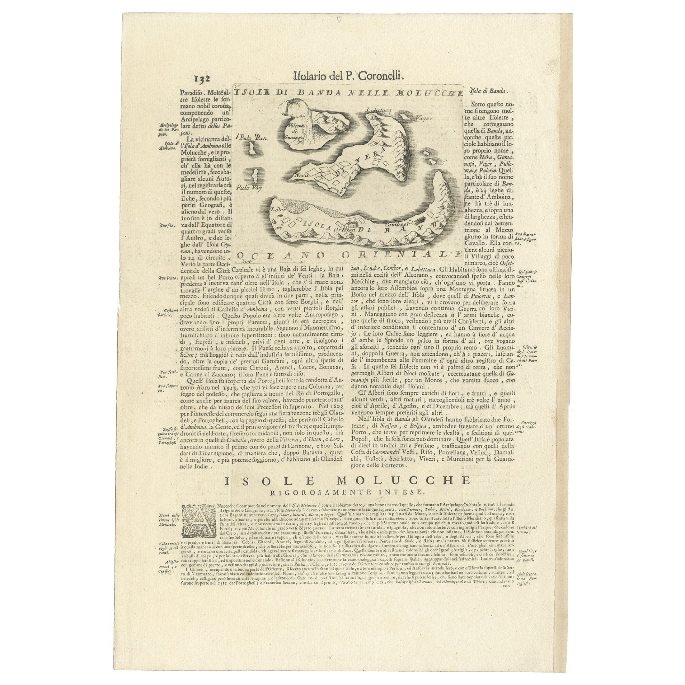
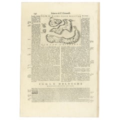
Antique Map of the Banda Islands or Spice Islands, Moluccas, Indonesia, 1697
Located in Langweer, NL
Antique map titled 'Isole di Banda Nelle Molucche'.
Engraved map of Isola di Banda, Nelle, Molucche. On verso: 'Isola di Solor'.
Artists and Engravers: Vincenzo Maria (Padre)...
Category
Antique 17th Century Maps
Materials
Paper
$420 Sale Price
20% Off
Original Antique Map Southeast of the Banda or Spice Islands, Indonesia, 1726
Located in Langweer, NL
Antique map titled 'Kaart van de Zuyd-Ooster Eylanden van Banda'.
Map of the southeastern part of the Banda islands. This map originates from 'Oud en Nieuw Oost-Indiën' by F. Valen...
Category
Antique 1720s Maps
Materials
Paper

$718 Sale Price
20% Off
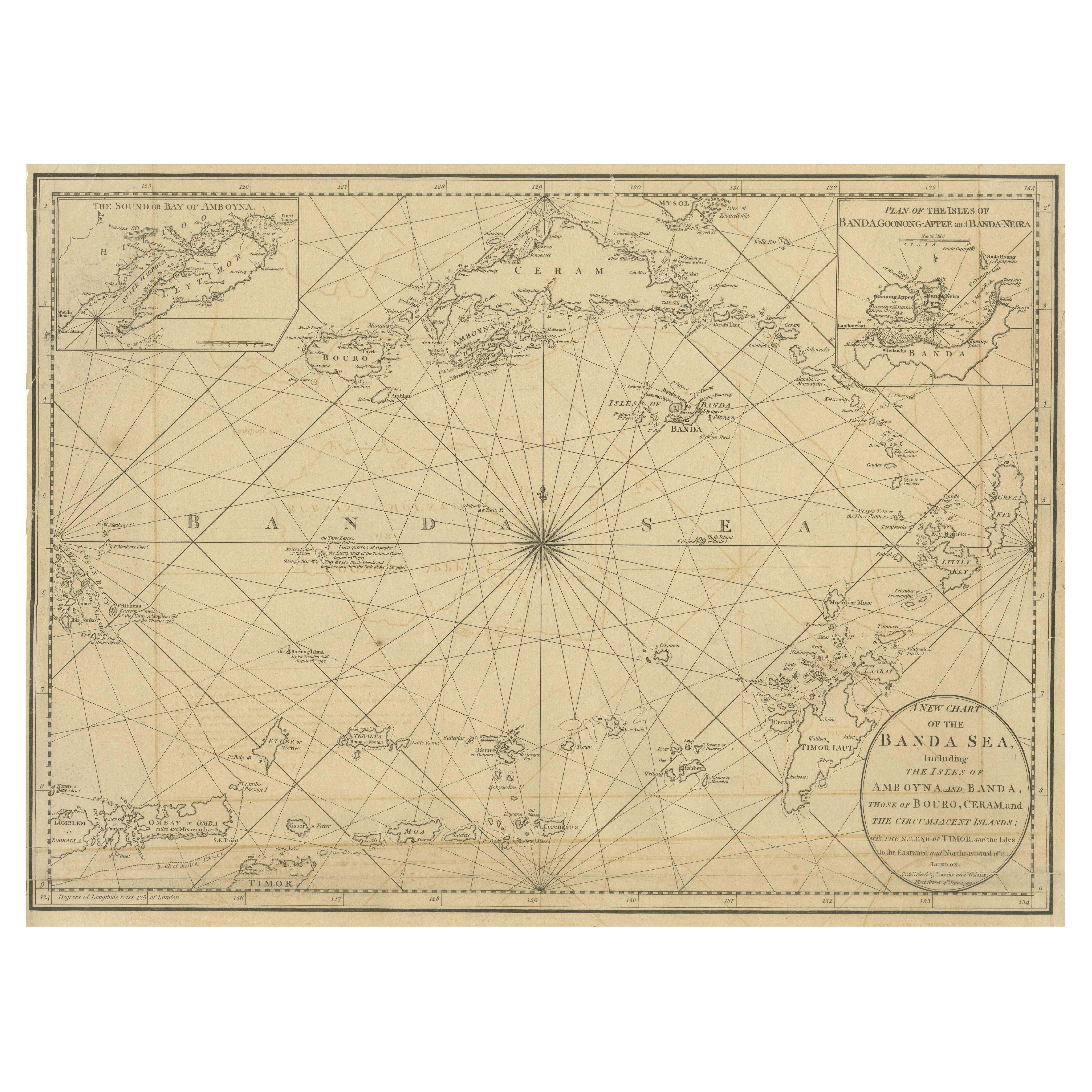
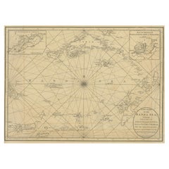
Navigating the Spice Trade: A Maritime Chart of the Banda Sea, 1799
Located in Langweer, NL
This original antique map is an 18th-century nautical chart by Laurie & Whittle, a well-known British firm that was involved in the publication of maps, charts, and maritime books. ...
Category
Antique Late 18th Century Maps
Materials
Paper
$924 Sale Price
20% Off
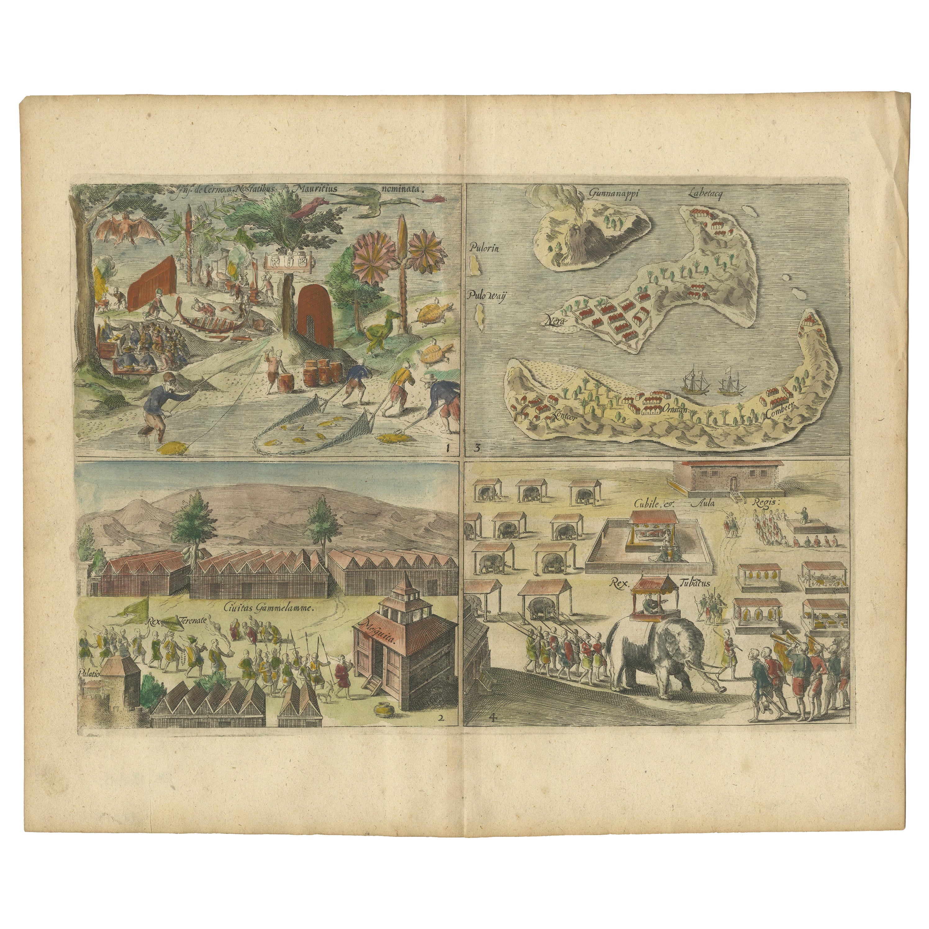
Antique Engravings of Mauritius and Indonesia, incl de Banda Islands, c.1730
Located in Langweer, NL
Title on page: "Ins. de Cerno a. Nostatibus Mauritius Nominata [on sheet with] Gunnanappi Labetacq [and] Civitas Gammelamme [and] Rex Tubatus", Le Clerc, Jean
This sheet includes fo...
Category
Antique 1730s Maps
Materials
Paper

$512 Sale Price
20% Off
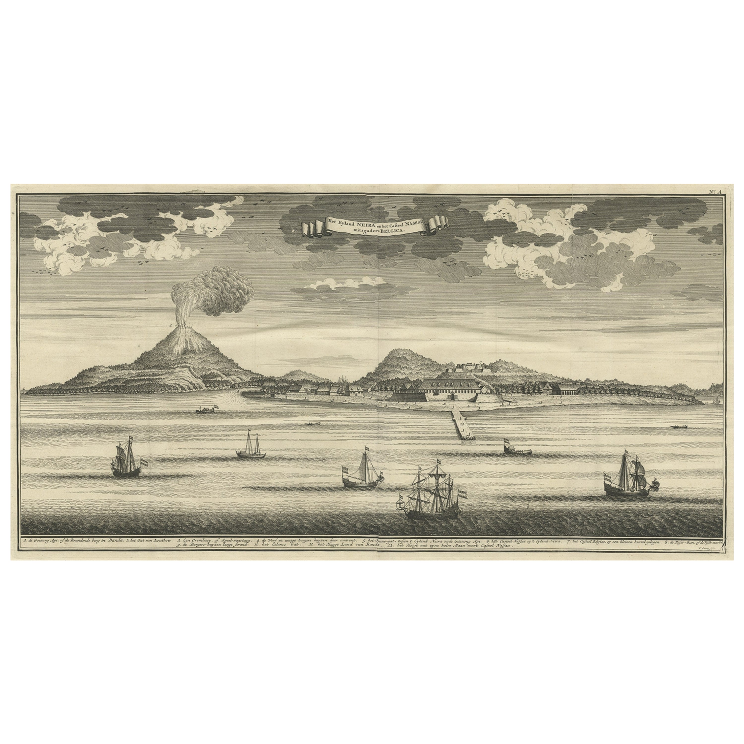
Beautiful Old View of Spice Island Banda Neira with Fort Nassau, Indonesia, 1726
Located in Langweer, NL
Antique print titled 'Het Eyland Neira, en het Casteel Nassau mitsgaders Belgica'.
Beautiful view of Banda Neira with Fort Nassau, Indonesia. This print originates from 'Oud en Nie...
Category
Antique 1720s Maps
Materials
Paper
$886 Sale Price
20% Off
You May Also Like
"The Masterpieces of Engraving"
By Eugene Maxime Vallée
Located in Alessandria, Piemonte
O/7821 - interesting French book that I saved from ruin: they are usually dismembered to make prints to sell individually. This one is intact, with its 24 printed plates. Nice to ...
Category
Antique Mid-19th Century French Other Books
Materials
Paper
1865 Chart of the Islands of Madeira
Located in Norwell, MA
Rare James Imray chart from 1865 titled "Chart of the Islands of Madeira, Porto Santo and Dezerea" drawn from the survey made by Captain Ate Vidal Royal Navy, London. Published by Ja...
Category
Antique 1860s European Maps
Materials
Paper

Vintage Exploration: Realms of the Persian Gulf, 1970, USSR, 1J141
Located in Bordeaux, FR
Embark on a journey of exploration with this vintage book titled "Княжества Персидского залива" (Realms of the Persian Gulf). Originating from Moscow in the USSR and dating back to 1...
Category
Vintage 1970s Books
Materials
Paper
Asia in Amsterdam: The Culture of Luxury in the Golden Age by Karina Corrigan
Located in valatie, NY
Asia in Amsterdam: The Culture of Luxury in the Golden Age by Karina Corrigan. 1st Ed hardcover exhibition catalog. Published by Peabody Essex Museum / Yale University, 2015. Hardcov...
Category
21st Century and Contemporary American Books
Materials
Paper

Picasso and the Age of Iron
Located in Richmond, VA
Vintage hardback coffee table book that discusses the artist’s bold experimentation with industrial materials during the mid-20th century. Essays by Pablo Picasso and other leading a...
Category
1990s Books
Materials
Paper
“The Restaurant of the House of Representatives” Engraving by Harper's Weekly
Located in Colorado Springs, CO
This original wood engraving is titled “The Restaurant of the House of Representatives, Washington, DC.” It was published as a double-page image, in the August 12, 1893 issue of the famous 19th century newspaper Harper’s Weekly. The print was illustrated by Charles Stanley Reinhardt.
The House Restaurant, a unique part of life in the Capitol, has been in the same location since the 1857 Capitol Expansion. Congressional members’ busy work schedule made the availability of food on site a necessity. But the restaurant also served as an informal meeting spot for members to continue conversations and deal making.
This 1893 print illustrates the convivial atmosphere. Details including elegantly dressed tables...
Category
Antique 1890s American Prints
Materials
Paper

Recently Viewed
View AllMore Ways To Browse
Silver Plate Art Deco Cocktail Shaker
Small Dining Table With Extension
Square Club Chair
Sterling Condiment
Sugar Creamer Tray
Swivel Ottomans
Tavolino Coffee Table
Three Seat Leather Danish Sofa
Tooled Leather Chairs
Trestle Chair
Trophy Silver Cup
Turkish Textile Framed
Tweed Upholstery
Twist Pedestal Table
Vintage 1950s Hat
Vintage Limestone Table
Vintage Louis Vuitton Trunks
Vintage Rattan Tray