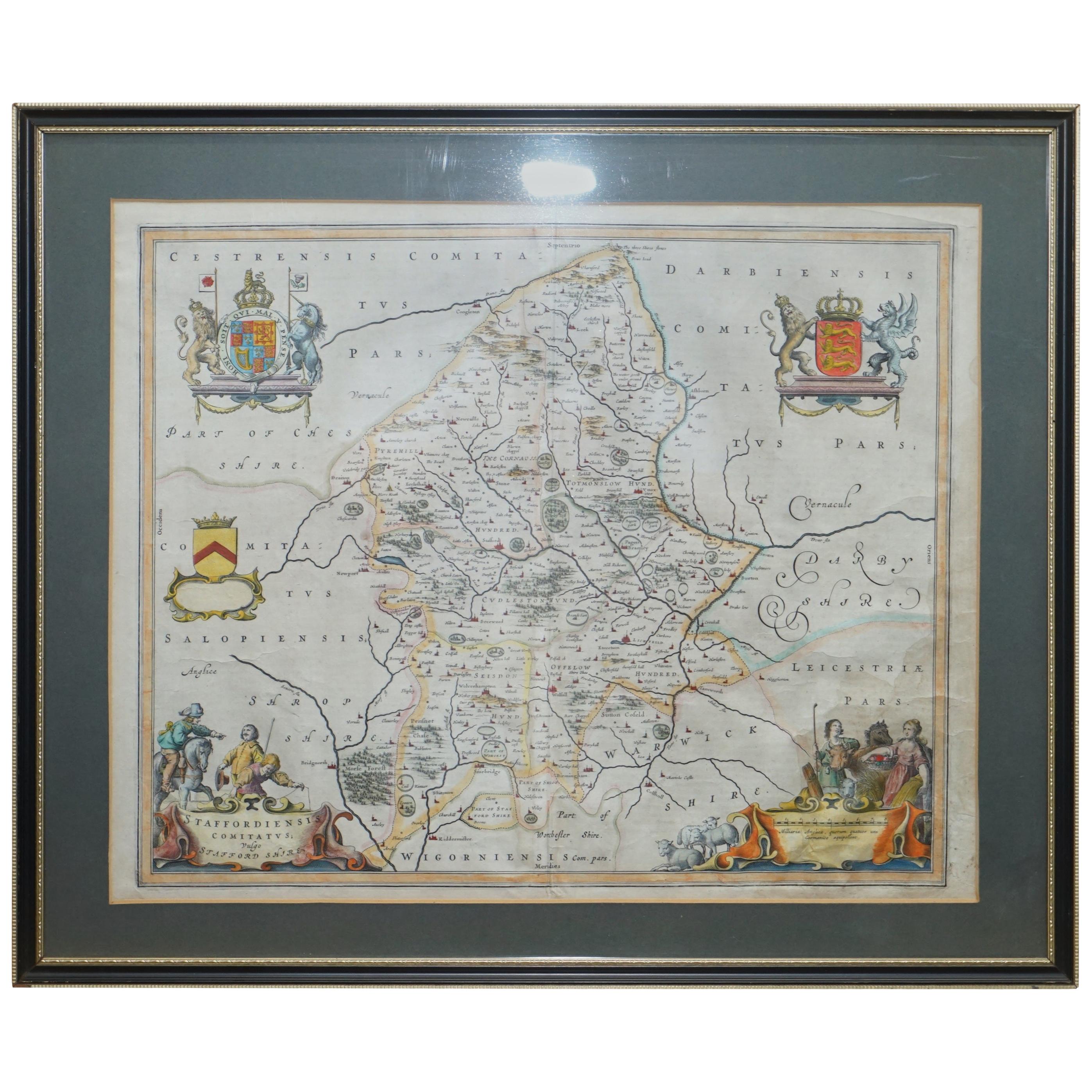
Items Similar to Staffordshire 1645 Hand Colored Antique Print Staffordiensis Comitatvs Map


Want more images or videos?
Request additional images or videos from the seller
1 of 14
Staffordshire 1645 Hand Colored Antique Print Staffordiensis Comitatvs Map
$493.46
$616.8220% Off
£360
£45020% Off
€429.10
€536.3720% Off
CA$674.27
CA$842.8420% Off
A$760.13
A$950.1720% Off
CHF 402.89
CHF 503.6220% Off
MX$9,371.30
MX$11,714.1320% Off
NOK 4,897.67
NOK 6,122.0920% Off
SEK 4,707.44
SEK 5,884.3120% Off
DKK 3,200.32
DKK 4,000.4020% Off
Shipping
Retrieving quote...The 1stDibs Promise:
Authenticity Guarantee,
Money-Back Guarantee,
24-Hour Cancellation
About the Item
We are delighted to offer for sale this lovely antique Atlas page map of Staffordshire printed in 1645 Amsterdam Staffordiensis Comitatvs Vulgo
This one is two pages from an antique atlas, it has been plate printed and hand coloured, the detail is exquisite, you can see the plate print impression around the edges and hand written notation number
I have no idea on the age, it looks circa 1800 to me, it was originally printed in 1645 by Joan Bleau so could be older
Dimensions
Height 57cm
Width 64.3cm
Depth 2.5cm
Please note all measurements are taken at the widest point
This item is available for collection from our Wimbledon warehouses
Condition
Please view the very detailed pictures as they form part of the description around condition
Please note vintage period and original items such as leather seating will always have natural patina in the form of cracking creasing and wear, we recommend regular waxing to ensure no moisture is lost, also hand dyed leather is not recommended to sit in direct sunlight for prolonged periods of time as it will dry out and fade.
- Dimensions:Height: 22.45 in (57 cm)Width: 25.32 in (64.3 cm)Depth: 0.99 in (2.5 cm)
- Style:Georgian (Of the Period)
- Materials and Techniques:
- Place of Origin:
- Period:
- Date of Manufacture:1800
- Condition:Wear consistent with age and use. Minor fading.
- Seller Location:West Sussex, GB
- Reference Number:1stDibs: LU2823320358872
About the Seller
4.7
Platinum Seller
Premium sellers with a 4.7+ rating and 24-hour response times
Established in 2012
1stDibs seller since 2017
1,980 sales on 1stDibs
Typical response time: 1 hour
- ShippingRetrieving quote...Shipping from: West Sussex, United Kingdom
- Return Policy
Authenticity Guarantee
In the unlikely event there’s an issue with an item’s authenticity, contact us within 1 year for a full refund. DetailsMoney-Back Guarantee
If your item is not as described, is damaged in transit, or does not arrive, contact us within 7 days for a full refund. Details24-Hour Cancellation
You have a 24-hour grace period in which to reconsider your purchase, with no questions asked.Vetted Professional Sellers
Our world-class sellers must adhere to strict standards for service and quality, maintaining the integrity of our listings.Price-Match Guarantee
If you find that a seller listed the same item for a lower price elsewhere, we’ll match it.Trusted Global Delivery
Our best-in-class carrier network provides specialized shipping options worldwide, including custom delivery.More From This Seller
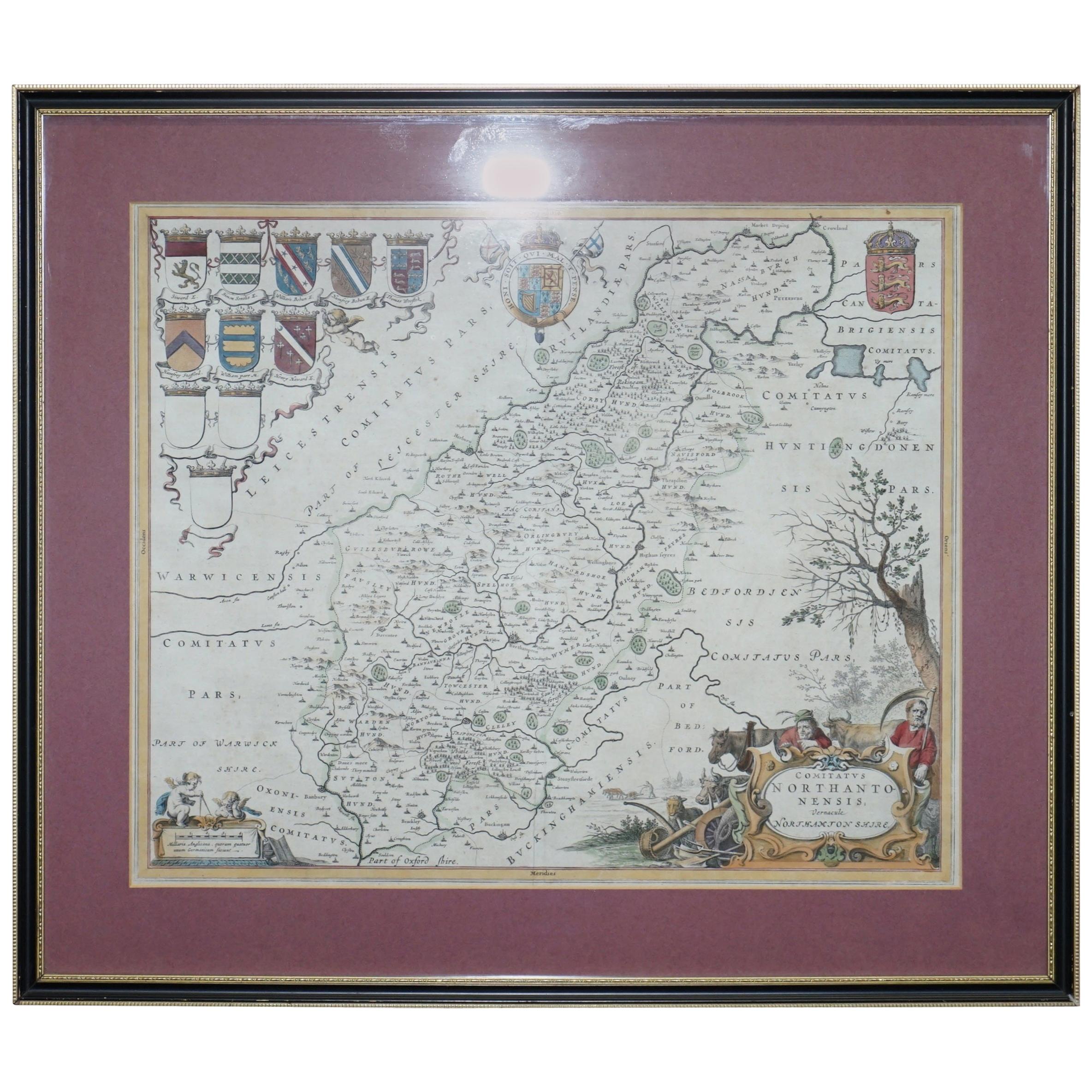
View AllDouble Sided Northamptonshire 1645 Hand Colored Antique Print Map Rare Find
Located in West Sussex, Pulborough
We are delighted to this lovely antique Atlas page map of Northamptonshire printed in 1645 Amsterdam Staffordiensis Comitatvs Vulgo
I have three of th...
Category
Antique Early 1800s English Georgian Maps
Materials
Paper

$493 Sale Price
20% Off
Double Sided and Glazed Cheshire 1645 Hand Colored Antique Print Map Rare Find
Located in West Sussex, Pulborough
We are delighted to offer for sale this lovely antique Atlas page map of Cheshire printed in 1645 Amsterdam Staffordiensis Comitatvs Vulgo
I have thre...
Category
Antique Early 1800s English Georgian Maps
Materials
Paper
$493 Sale Price
20% Off
Fine French Antique 1856 Hand Watercolour Map of Dept Des Hautes Pyrenees
Located in West Sussex, Pulborough
We are delighted to offer for sale this stunning 1856 hand watercolour map of the Austrian Alps titled Dept Des Hautes Pyrenees taken from the Atlas Nat...
Category
Antique 1850s French Early Victorian Maps
Materials
Paper

$822 Sale Price
20% Off
Beautiful Colour French Antique 1856 Hand Watercolour Map of Dept Des La Corse
Located in West Sussex, Pulborough
We are delighted to offer for sale this stunning 1856 hand watercolour map of the Austrian Alps titled Dept Des La Course taken from the Atlas National ...
Category
Antique 1850s French Early Victorian Maps
Materials
Paper

$932 Sale Price
20% Off
Fine Antique 1856 Hand Watercolour Map of Dept Des Hautes Alpes by Levasseur's
Located in West Sussex, Pulborough
We are delighted to offer for sale this stunning 1856 hand watercolour map of the Austrian Alps titled Dept Des Hautes Alpes taken from the Atlas National...
Category
Antique 1850s French Early Victorian Maps
Materials
Paper

$822 Sale Price
20% Off
London 1744 Published Watercolour Antique Map of East Africa by Eman Bowen
Located in West Sussex, Pulborough
We are delighted to offer for sale this New and Accurate Map of Nubia & Abissinia, together with all the Kingdoms Tributary Thereto, and bordering upon them published in 1744 by Emanuel Bowen
This is a decorative antique engraved map of East Africa...
Category
Antique 1740s English George III Maps
Materials
Paper

$1,041 Sale Price
20% Off
You May Also Like
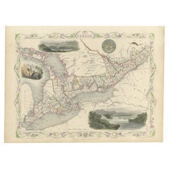
Beautiful Decorative Hand-Colored Antique Map of West Canada, 1851
Located in Langweer, NL
Description: Antique map of Canada titled 'West Canada'.
With decorative vignettes titled Kingston and Falls of Niagara. Originates from 'The Illustrated Atlas, And Modern History Of The World Geographical, Political, Commercial & Statistical, Edited By R. Montgomery Martin'. Published; John Tallis London, New York, Edinburgh & Dublin. 1851.
Drawn and Engraved by J. Rapkin.
Artists and Engravers: John Tallis (1817-1876) was a British map...
Category
Antique 1850s Maps
Materials
Paper
$891 Sale Price
20% Off
Antique Hand-Colored Map of France by J.B. Elwe, 1792
Located in Langweer, NL
Antique map titled 'Carte Nouvelle du Royaume de France'. Beautiful antique map of France, including the Southern part of England. Decorated with cartouche and 12 coats of arms.
Category
Antique Late 18th Century Maps
Materials
Paper

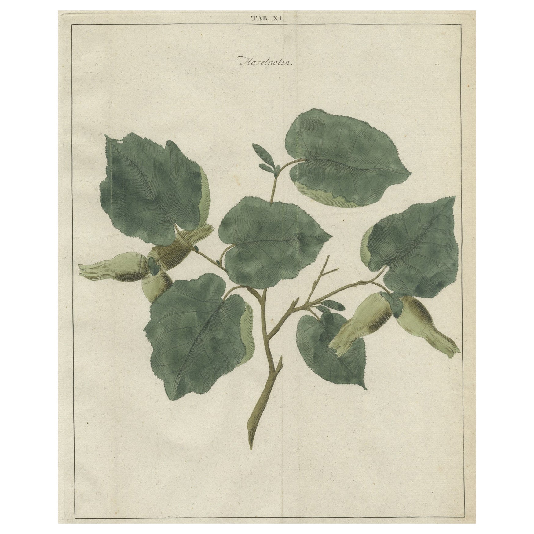
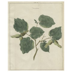
Antique Hand-Colored Print of the Common Hazel, 1758
Located in Langweer, NL
Antique print of the common hazel. Originates from 'Pomologia' by J. H. Knoop.
Artists and Engravers: Published by Johann Hermann Knoop (c.1700-1769).
Condition: Good, general ...
Category
Antique 18th Century Maps
Materials
Paper
$309 Sale Price
20% Off
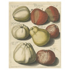
Original Antique Hand-Colored Print of Various Apples, 1758
Located in Langweer, NL
Antique print depicting apple variaties including Witte Kruid-Appel, Rode Somer-Calville, Rode Jopen, Witte Somer-Calville, Somer Citroen Appel, Somer Kroon, Engelse Carolyn, Roos-Ap...
Category
Antique 18th Century Maps
Materials
Paper
$300 Sale Price
20% Off
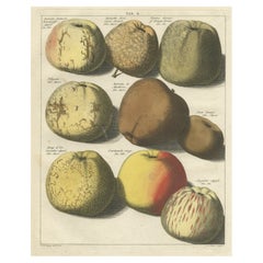
Original Hand-Colored Antique Print of Various Apples, 1758
Located in Langweer, NL
Antique print depicting apple variaties including the Borsdorsser Appel, Goud-Reinet, Krappe-Kruin, Nelguin, Reinette de Montbron, Caracter Appel, Soete Veentje, Courtpendu Rouge, An...
Category
Antique 18th Century Maps
Materials
Paper
$300 Sale Price
20% Off
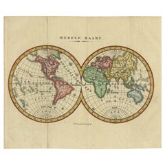
Small Antique World Map in Decorative Old Hand-Colouring, circa 1840
Located in Langweer, NL
Antique map titled 'Wereld Kaart'. Small and very decorative double hemisphere world map. Source unknown, to be determined. Published c.1840.
Artists and Engravers: Daniel Veelwaa...
Category
Antique 19th Century Maps
Materials
Paper
$206 Sale Price
20% Off
More Ways To Browse
Milo Baughman Chrome Stools
Milo Baughman Patchwork
Mobler Bench
Mocha Pot
Mogensen Hunting Chair
Moorish Fretwork
Moorish Side Table Mother Of Pearl
Morelato Bellagio
Moroccan Tile Table
Morrocan Moorish Hexagonal Table
Moulins Des Loups
Mueller Furniture Mid Century
Murano Glass Etched Tray
Mushroom Wallpaper
Nachtmann Crystal
Nakashima Cushion
Narra Wood Furniture
Narra Wood