Items Similar to Utrecht Province Map 1907 – Antique Dutch Topographic Kuyper Lithograph

Want more images or videos?
Request additional images or videos from the seller
1 of 10
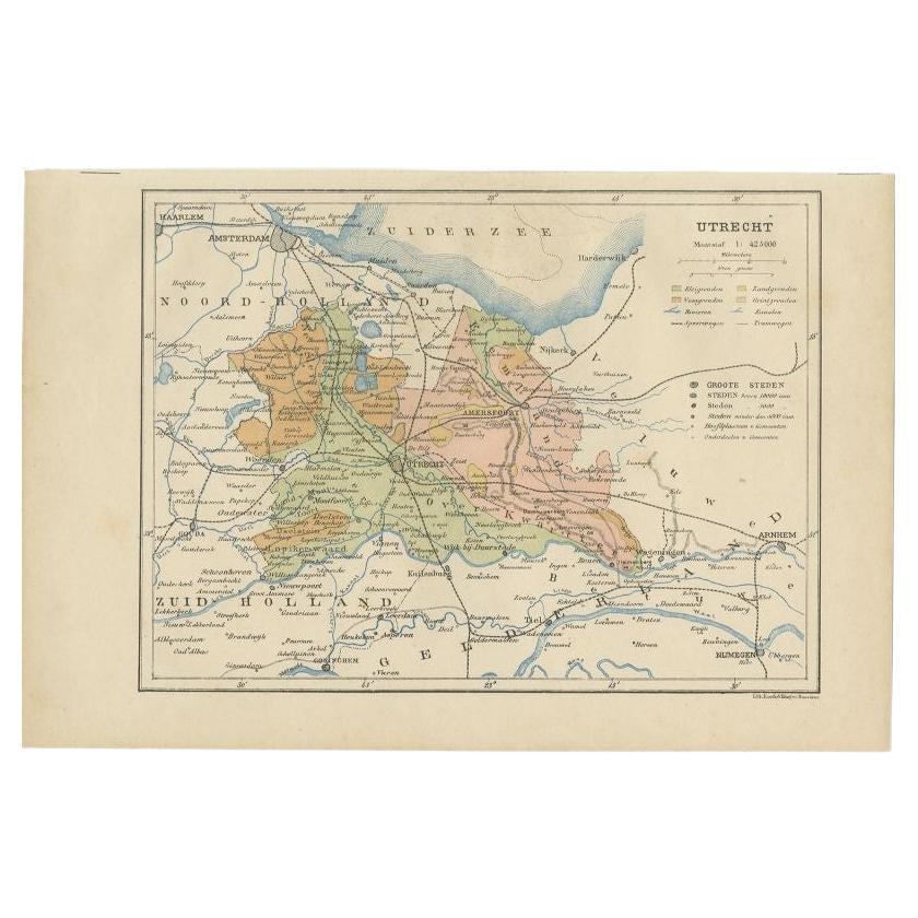
Utrecht Province Map 1907 – Antique Dutch Topographic Kuyper Lithograph
$391.31
£290.77
€330
CA$541.60
A$603.11
CHF 314.90
MX$7,307.79
NOK 3,971.19
SEK 3,747.13
DKK 2,512.68
About the Item
Utrecht Province Map 1907 – Antique Dutch Topographic Kuyper Lithograph
This antique map of the province of Utrecht, titled “Utrecht. Uitgegeven en getekend door J. Kuyper”, was published in 1907 by W\.E.J. Tjeenk Willink in Zwolle. It is a highly detailed lithographed map of one of the Netherlands’ central provinces, known for its rich history, medieval cities, and varied landscapes.
The map shows the entire province of Utrecht in remarkable detail, with boundaries, waterways, railroads, and settlements clearly marked. Cities such as Utrecht, Amersfoort, and Zeist are shown with surrounding towns, villages, and rural areas, making the map a valuable geographic record from the early 20th century. The province’s dense network of canals, dikes, and rivers is finely engraved, emphasizing Utrecht’s role within the Dutch system of water management.
Shaded areas highlight woodlands, heathlands, and other natural features, with the Utrechtse Heuvelrug (Utrecht Hill Ridge) prominently marked. Railroads and tram lines are also carefully delineated, reflecting the increasing modernization of Dutch transport infrastructure at the beginning of the 20th century. The Zuiderzee (now the IJsselmeer) is shown along the northern border, predating the Afsluitdijk (1932) and subsequent land reclamation that reshaped the Netherlands in the 20th century.
Kuyper’s maps, published by W\.E.J. Tjeenk Willink, were known for their clarity and accuracy, widely used in schools and administration. Today, they provide a historical window into Dutch geography before major 20th-century transformations, such as the Zuiderzee Works and post-war urban expansion.
Condition: Good, with light age toning and fold lines as issued. Some small marginal tears and handling creases, but image remains clean and paper stable.
Framing tips: A simple black or dark oak frame with a cream mat will emphasize the fine cartographic detail. A secondary green mat could highlight the provincial borders and natural areas.
Technique: Lithograph with printed color
Maker: J. Kuyper, published by W\.E.J. Tjeenk Willink, Zwolle, 1907
- Dimensions:Height: 17.72 in (45 cm)Width: 23.63 in (60 cm)Depth: 0.01 in (0.2 mm)
- Materials and Techniques:
- Place of Origin:
- Period:
- Date of Manufacture:1907
- Condition:Condition: Good, with light age toning and fold lines as issued. Some small marginal tears and handling creases, but image remains clean and paper stable.
- Seller Location:Langweer, NL
- Reference Number:Seller: BG-070851stDibs: LU3054346391552
About the Seller
5.0
Recognized Seller
These prestigious sellers are industry leaders and represent the highest echelon for item quality and design.
Platinum Seller
Premium sellers with a 4.7+ rating and 24-hour response times
Established in 2009
1stDibs seller since 2017
2,589 sales on 1stDibs
Typical response time: <1 hour
- ShippingRetrieving quote...Shipping from: Langweer, Netherlands
- Return Policy
Authenticity Guarantee
In the unlikely event there’s an issue with an item’s authenticity, contact us within 1 year for a full refund. DetailsMoney-Back Guarantee
If your item is not as described, is damaged in transit, or does not arrive, contact us within 7 days for a full refund. Details24-Hour Cancellation
You have a 24-hour grace period in which to reconsider your purchase, with no questions asked.Vetted Professional Sellers
Our world-class sellers must adhere to strict standards for service and quality, maintaining the integrity of our listings.Price-Match Guarantee
If you find that a seller listed the same item for a lower price elsewhere, we’ll match it.Trusted Global Delivery
Our best-in-class carrier network provides specialized shipping options worldwide, including custom delivery.More From This Seller
View AllAntique Map of Utrecht in The Netherlands, 1883
Located in Langweer, NL
Antique map titled 'Utrecht'. Map of Utrecht, a province of the Netherlands. This map originates from 'Atlas van Nederland volgens de nieuwe spelregels' by J. Kuyper.
Artists and En...
Category
Antique 19th Century Maps
Materials
Paper

$208 Sale Price
20% Off
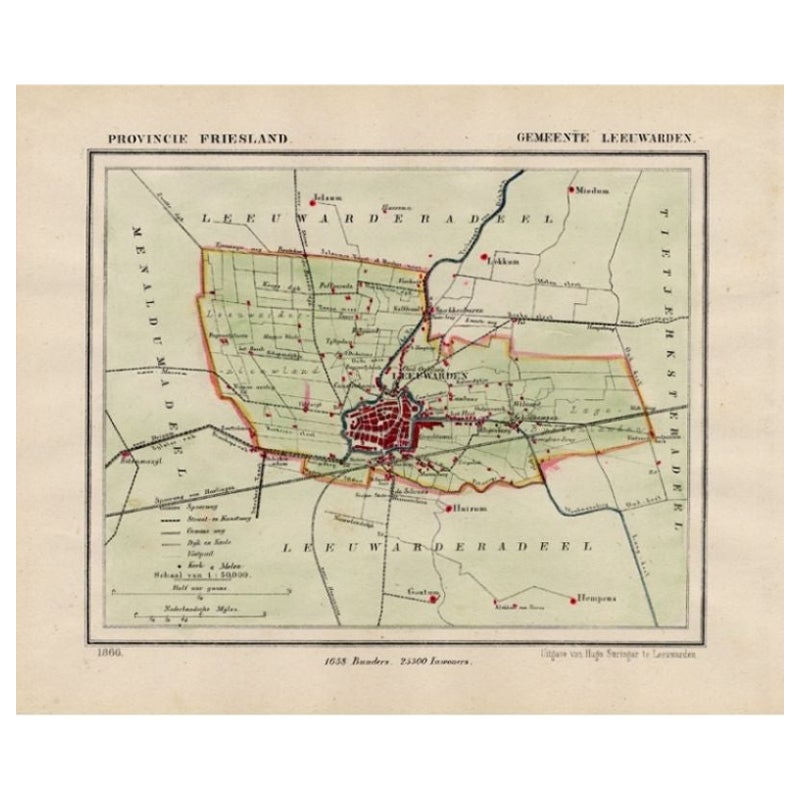
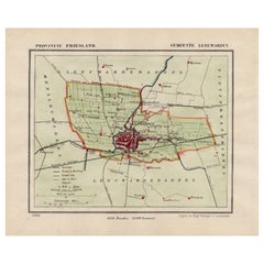
Antique Map of Leeuwarden and Surroundings, in Friesland, the Netherlands, 1865
Located in Langweer, NL
Friesland: Gemeente Leeuwarden. These scarse detailed maps of Dutch Towns originate from the 'Gemeente-atlas' of Jacob Kuyper. This atlas of all towns in the Netherlands was publishe...
Category
Antique 19th Century Maps
Materials
Paper
$208 Sale Price
20% Off
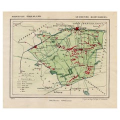
Antique Map of The Dutch Township Rauwerderhem, 1861
Located in Langweer, NL
Antique map titled 'Gemeente Rauwerderhem'. Old map depicting the Rauwerderhem township including cities and villages like Deersum, Poppingawier, Rauwerd and Irnsum. This map orginat...
Category
Antique 19th Century Maps
Materials
Paper

$113 Sale Price
20% Off
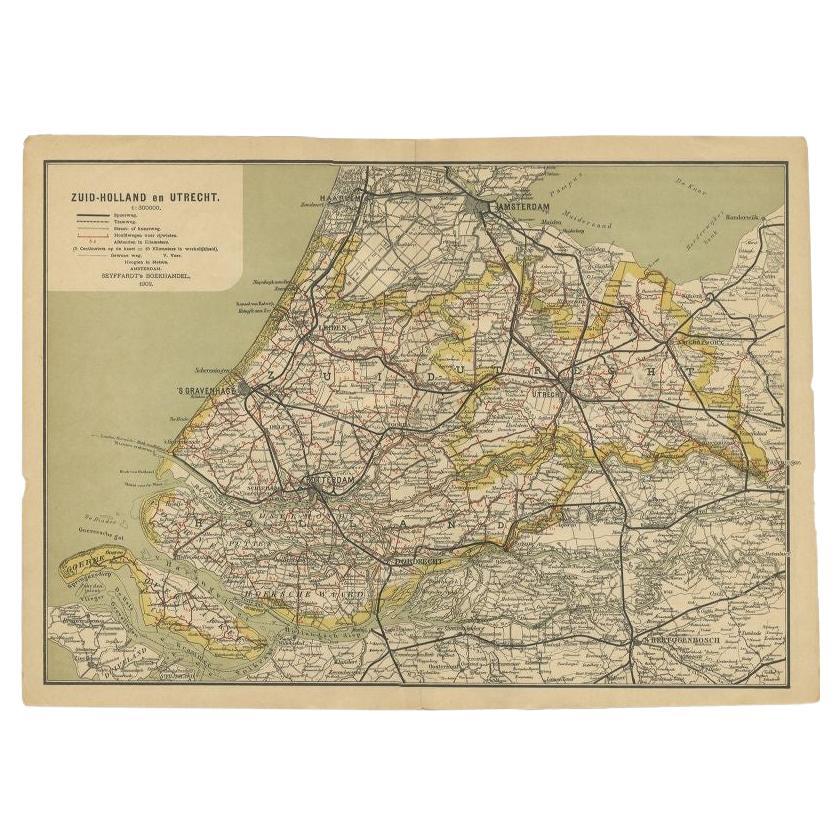
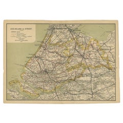
Antique Map of Zuid-Holland and Utrecht in The Netherlands, 1902
Located in Langweer, NL
Antique map titled 'Zuid-Holland en Utrecht'. Lithographed map of the provinces of Zuid-Holland and Utrecht, the Netherlands. This map originates from 'Atlas van Nederland'.
Artist...
Category
20th Century Maps
Materials
Paper
$123 Sale Price
20% Off
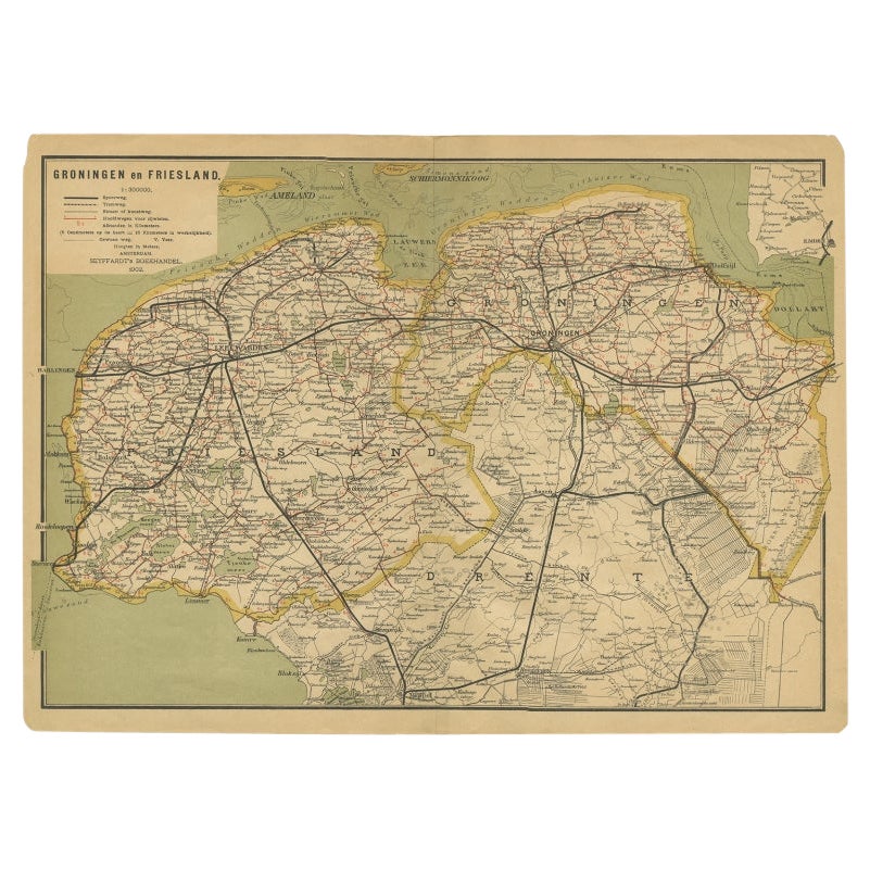
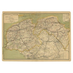
Antique Map of the Dutch Provinces Groningen and Friesland, 1902
Located in Langweer, NL
Antique map titled 'Groningen en Friesland'. Lithographed map of the provinces of Groningen and Friesland, the Netherlands. This map originates from 'Atlas van Nederland'. Artists an...
Category
20th Century Maps
Materials
Paper
$132 Sale Price
20% Off
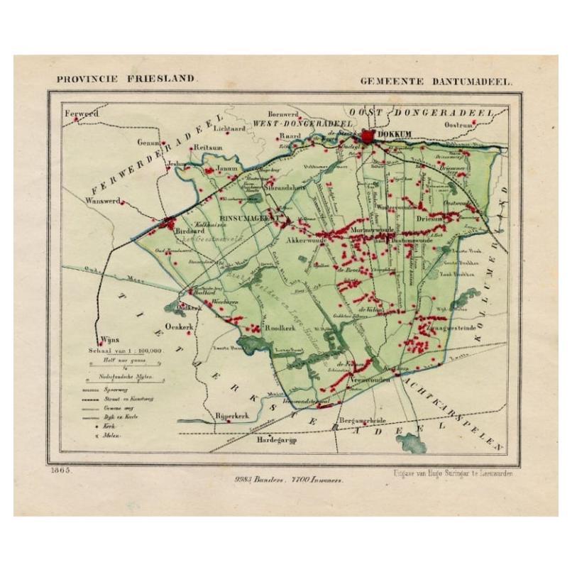
Antique Map of Dantumadeel, Friesland, The Netherlands, 1868
Located in Langweer, NL
Antique map titled 'Provincie Friesland - Gemeente Dantumadeel'. Map of the township of Dantumadeel including Birdaard, Rinsumageest, Veenwouden and many other villages. This map ori...
Category
Antique 19th Century Maps
Materials
Paper
$102 Sale Price
20% Off
You May Also Like
Original Antique Map or City Plan of Amsterdam, Netherlands. Circa 1835
Located in St Annes, Lancashire
Nice map of Amsterdam
Drawn and engraved by J.Dower
Published by Orr & Smith. C.1835
Unframed.
Free shipping
Category
Antique 1830s English Maps
Materials
Paper

The Netherlands (Holland), Belgium and Luxemburg. Century Atlas antique map
Located in Melbourne, Victoria
'The Century Atlas. The Netherlands (Holland), Belgium and Luxemburg.'
Original antique map, 1903.
Inset maps of 'Amsterdam' and 'Brussels'.
Central fold as issued. Map name and num...
Category
Early 20th Century Victorian More Prints
Materials
Lithograph

Utrecht, Antique Map from "Civitates Orbis Terrarum"
By Franz Hogenberg
Located in Roma, IT
Braun G., Hogenberg F., Traiectum or Utrecht, from the collection Civitates Orbis Terrarum, Cologne, T. Graminaeus, 1572-1617.
Very fine B/W aquatint showing a view of Utrecht, with...
Category
16th Century Landscape Prints
Materials
Etching

Utrecht, Netherlands: A Large 17th Century Hand-colored Map by Sanson & Jaillot
By Nicholas Sanson d'Abbeville
Located in Alamo, CA
This large hand-colored map entitled "La Seigneurie d'Utrecht. Dressé sur les memoires les plus nouveaux par le Sr. Sanson" was originally created by Nicholas Sanson d'Abbeville. Thi...
Category
1690s Landscape Prints
Materials
Engraving

1752 Vaugoundy Map of Flanders : Belgium, France, and the Netherlands, Ric.a002
Located in Norton, MA
Large Vaugoundy Map of Flanders:
Belgium, France, and the Netherlands
Colored -1752
Ric.a002
Description: This is a 1752 Didier Robert de Vaugondy map of Flanders. The map de...
Category
Antique 17th Century Unknown Maps
Materials
Paper

Belgium and the Netherlands: A Hand-colored 17th Century Map by Visscher
By Nicolaus Visscher
Located in Alamo, CA
This is an original hand-colored 17th century map of Belgium by Nicolaus (Nicolas) Visscher II entitled "Belgium Foederatum emendate auctum et novissime editum", published in Amsterdam in 1678. The map shows the seven provinces comprising the Belgium federation or the Republic of the Seven United Netherlands or the Dutch Republic as it was also known. The republic was formed when an alliance of seven Dutch provinces in the Spanish Netherlands revolted against rule by Spain in 1579 (the Union of Utrecht) and declared their independence in 1581 (the Act of Abjuration). The seven provinces were Groningen, Frisia, Overijssel, Guelders, Utrecht, Holland and Zeeland. This was a predecessor state to the Netherlands and the first fully independent Dutch nation state. Amsterdam, Delft, Rouen, Utrecht, Brugge, Ghent, and Antwerp are all included on the map. A small inset map in the lower right depicts the course of the Maas River from Maastricht to Wessem. There is a decorative cartouche in the upper left corner and a distance scale cartouche in the lower right corner.
The map is presented in an attractive antiqued medium brown-colored wood frame with gold-colored inner and outer trim and a light tan-colored fabric mat. The frame measures 26.63" high by 30" wide by 0.75" deep. There is some darkening of the red areas in the map, presumably related to oxidation of the original iron containing pigment over time. There are also a few scattered spots. The map is otherwise in very good condition.
The Visscher family were one of the great cartographic families of the 17th century. Begun by Claes Jansz Visscher...
Category
Late 17th Century Other Art Style Landscape Prints
Materials
Engraving
