Items Similar to Vintage Reproduction 17th Century Map of Europe, American, Cartography, Blaeuw


Want more images or videos?
Request additional images or videos from the seller
1 of 11
Vintage Reproduction 17th Century Map of Europe, American, Cartography, Blaeuw
$1,264.58
£914
€1,089.57
CA$1,734.98
A$1,948.25
CHF 1,026.40
MX$24,115.03
NOK 12,707.54
SEK 12,098.12
DKK 8,127.96
Shipping
Retrieving quote...The 1stDibs Promise:
Authenticity Guarantee,
Money-Back Guarantee,
24-Hour Cancellation
About the Item
This is a vintage reproduction map of Europe. An American, paper stock cartography print in frame after the work by Blaeuw, dating to the late 20th century, circa 1970.
Fascinating reproduction of the historic cartography by Guilielmo Blaeuw (1571 - 1638)
Displays a desirable aged patina and in good order throughout
Appealing map print on quality paper stock, behind clear, bright glass
Framed within a quality, attractive wooden frame with beaded detail
After the original from 1630, the map shows 17th century Europe in colour
Annotated with countries, key cities and examples of national dress
Dressed to the eye-catching rear with mounting wire for ease of hanging
Custom framed in California for Lesko & Associates - an educational architecture specialist founded in 1953
This is a charming vintage reproduction map of Europe, with a nicely presented 17th century map of Europe presented in a quality frame. Delivered ready to display.
Under the pseudonym Guilielmo Blaeuw, Dutch cartographer, atlas maker and publisher Willem Janszoon Blaeu had an enviable body of published work. Mapping Europe, the Americas and providing much of the works in the Atlus Maior, Blaeuw was a comprehensive name in 17th century mapping.
Dimensions:
Max Width: 97.5cm (38.5'')
Max Depth: 3.5cm (1.5'')
Max Height: 77cm (30.25'')
Map Width: 48cm (19'')
Map Height: 69.5cm (27.25'')
- Dimensions:Height: 30.32 in (77 cm)Width: 38.39 in (97.5 cm)Depth: 1.38 in (3.5 cm)
- Style:Mid-Century Modern (Of the Period)
- Materials and Techniques:
- Place of Origin:Central America
- Period:
- Date of Manufacture:circa 1970
- Condition:Wear consistent with age and use. Presented in very good vintage condition.
- Seller Location:Hele, Devon, GB
- Reference Number:Seller: 18.98891stDibs: LU2645337996132
About the Seller
5.0
Platinum Seller
Premium sellers with a 4.7+ rating and 24-hour response times
Established in 2005
1stDibs seller since 2017
1,008 sales on 1stDibs
Typical response time: 1 hour
- ShippingRetrieving quote...Shipping from: Hele, Devon, United Kingdom
- Return Policy
Authenticity Guarantee
In the unlikely event there’s an issue with an item’s authenticity, contact us within 1 year for a full refund. DetailsMoney-Back Guarantee
If your item is not as described, is damaged in transit, or does not arrive, contact us within 7 days for a full refund. Details24-Hour Cancellation
You have a 24-hour grace period in which to reconsider your purchase, with no questions asked.Vetted Professional Sellers
Our world-class sellers must adhere to strict standards for service and quality, maintaining the integrity of our listings.Price-Match Guarantee
If you find that a seller listed the same item for a lower price elsewhere, we’ll match it.Trusted Global Delivery
Our best-in-class carrier network provides specialized shipping options worldwide, including custom delivery.More From This Seller
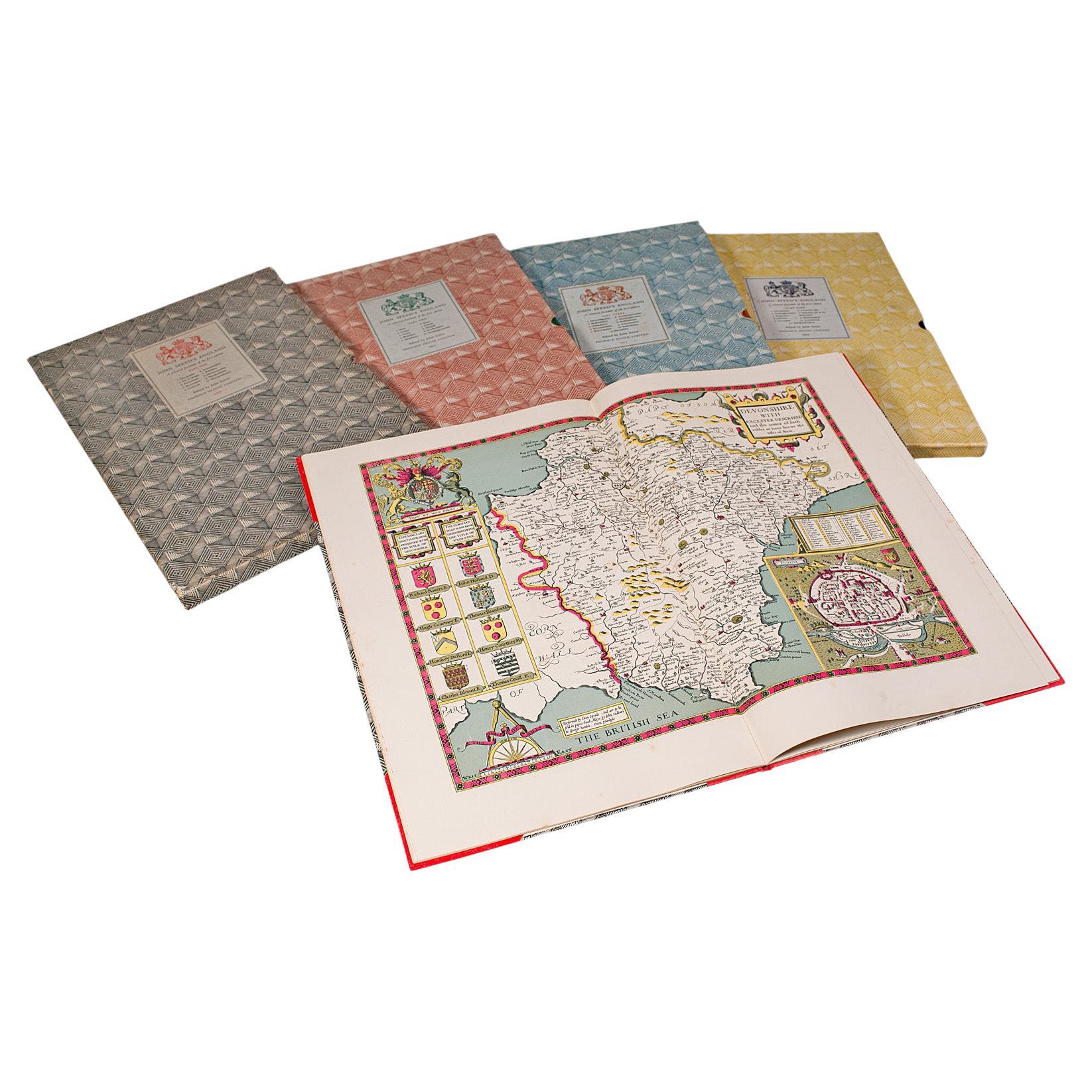
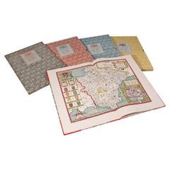
View All4 Vols Vintage English Maps, John Speed, Cartography Folio, Reproduction, C.1953
Located in Hele, Devon, GB
This is a vintage 4 volume compendium atlas of England by John Speed. An English, cartography folio, reproduced and presented in slip cases by John Arlott, dating to the mid 20th ce...
Category
Mid-20th Century British Mid-Century Modern Books
Materials
Paper
Antique Lithography Map, South America, English, Framed, Cartography, Victorian
Located in Hele, Devon, GB
This is an antique lithography map of South America. An English, framed atlas engraving of cartographic interest by John Rapkin , dating to the early Victorian period and later, circ...
Category
Antique Mid-19th Century British Early Victorian Maps
Materials
Wood

Very Large Vintage Map of Canada, German, Education, Institution, Cartography
Located in Hele, Devon, GB
This is a very large vintage map of Canada. A German, quality printed educational or institution map, dating to the mid 20th century, circa 1965....
Category
Mid-20th Century German Maps
Materials
Paper

Antique North America Map, USA, Canada, Mexico, Cartography, Colton, Victorian
Located in Hele, Devon, GB
This is an antique North America map. A USA, framed lithography atlas engraving of the continent by JH Colton, dating to the Victorian period and later, circa 1860.
Fascinating, large framed map...
Category
Antique Mid-19th Century American Victorian Maps
Materials
Paper

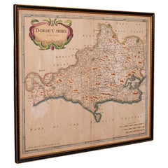
Large Antique 17th Century Dorset Map, Framed Cartography, Atlas, Robert Morden
Located in Hele, Devon, GB
This is an antique county map of Dorset. An English, framed atlas engraving of cartographic interest By Robert Morden, dating to the late 17th century and later.
Superb lithography ...
Category
Antique 1690s British William and Mary Decorative Art
Materials
Glass, Paper
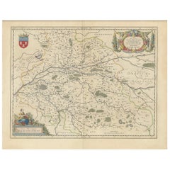
Antique County Map of Cheshire, Dutch, Framed, Cartography, Janssonius, C.1660
Located in Hele, Devon, GB
This is an antique county map of Cheshire. A Dutch, framed atlas engraving by Johannes Janssonius, dating to the 17th century and later.
A treat for the collector or county native,...
Category
Antique Mid-17th Century Dutch Charles II Maps
Materials
Glass, Wood, Paper

You May Also Like
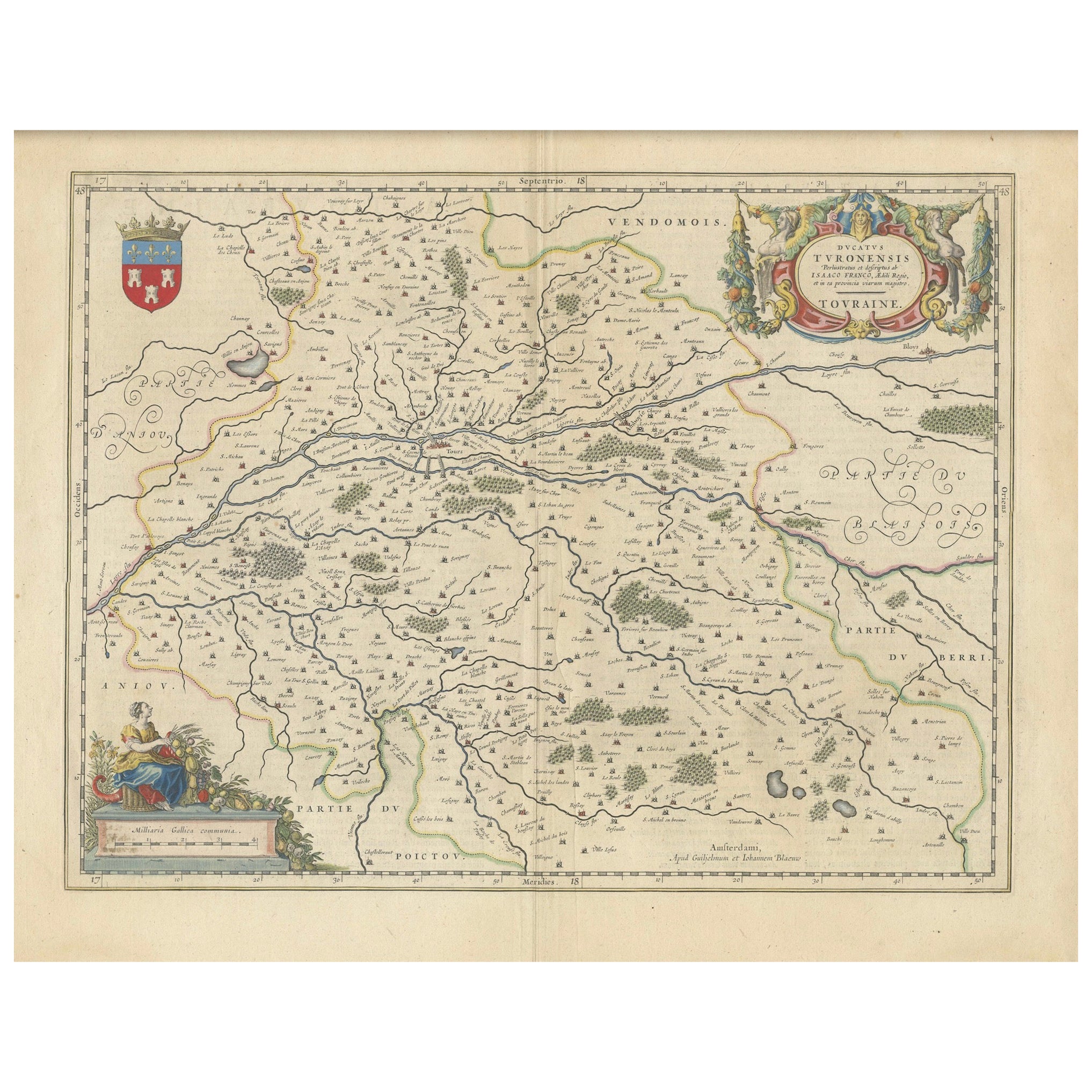
Cartographic Elegance of Touraine: A 17th-Century Map Showing French Heritage
Located in Langweer, NL
"Ducatus Turonensis - Touraine," is a original antique historical map of the Touraine region, which is located in the heart of France, centered...
Category
Antique 1630s Maps
Materials
Paper
$464 Sale Price
20% Off
Free Shipping
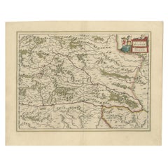
17th Century Nicolas Visscher Map of Southeastern Europe
Located in Hamilton, Ontario
A beautiful, highly detailed map of southeastern Europe by Nicolas Visscher. Includes regions of Northern Italy (showing the cities Bologna, Padua, and Venice), Bohemia, Austria (sho...
Category
Antique 17th Century Dutch Maps
Materials
Paper

$1,350 Sale Price
38% Off
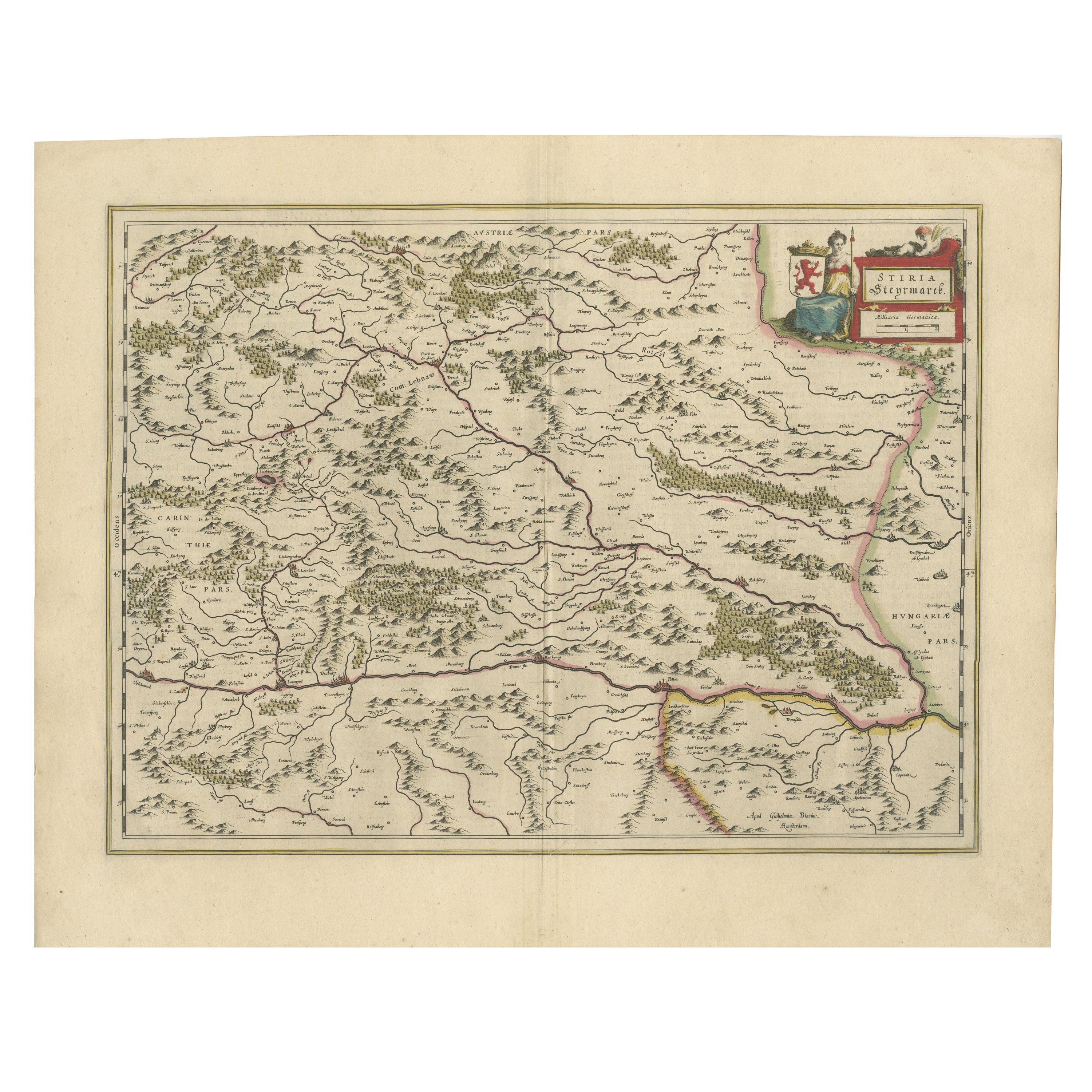
Map of Styria by William Blaeu, 1645: A Masterpiece of 17th-Century Cartography
Located in Langweer, NL
This 1645 map, created by Willem Janszoon Blaeu, represents Styria (Steyrmark), a historical region in present-day Austria, located in the Alpine regions. Blaeu, one of the most sign...
Category
Antique 1640s Maps
Materials
Paper
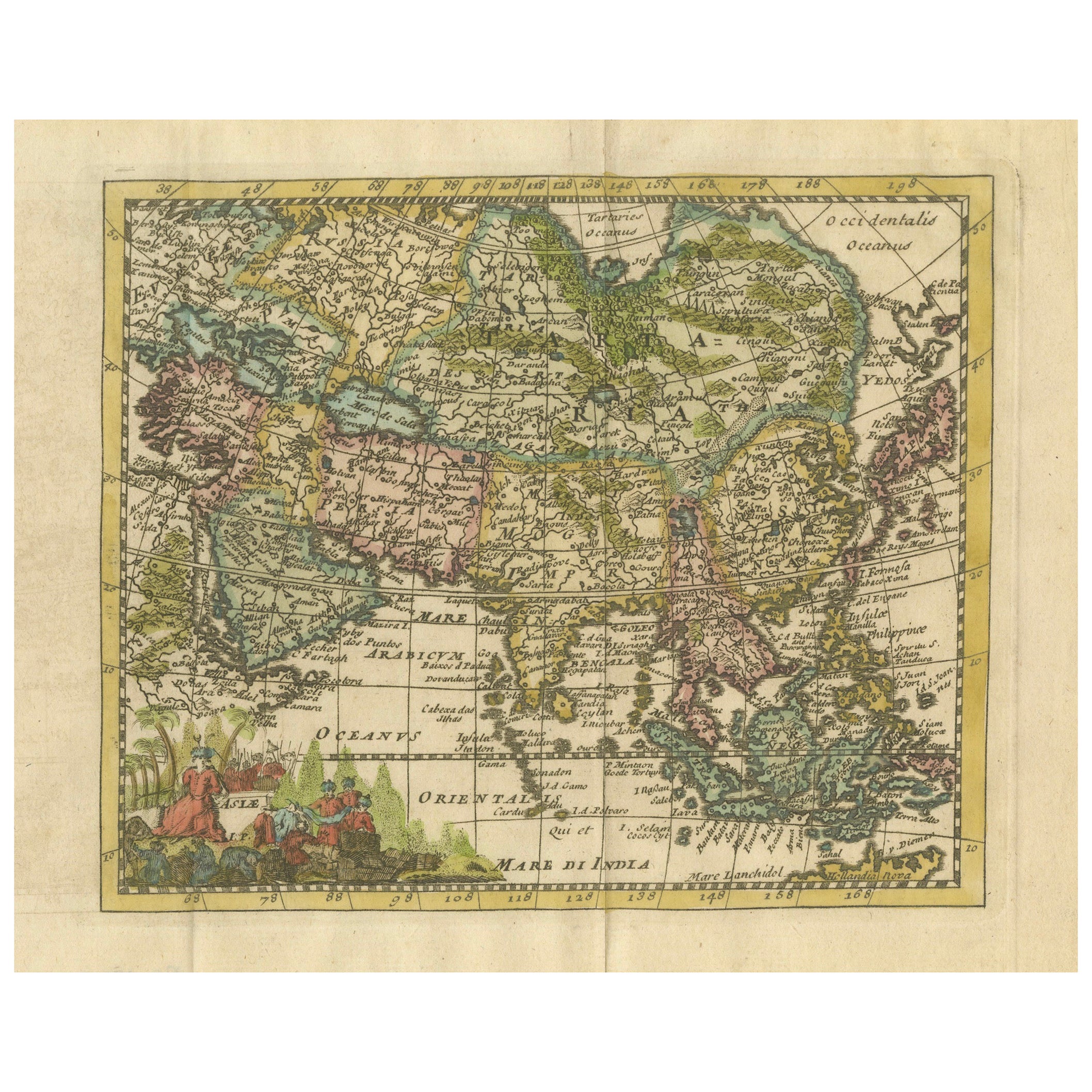
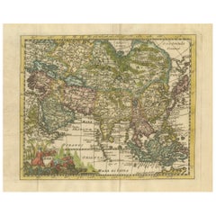
Cartographic Elegance: The Art and Science of 17th-Century Asian Maps, ca.1681
Located in Langweer, NL
This original antique map is an artifact from a pivotal era in cartography, reflecting not only the geographical knowledge of its time but also the intertwining of art and science in...
Category
Antique 1680s Maps
Materials
Paper
$369 Sale Price
20% Off
17th Century Cartographic Marvel: A Detailed Engraving of Guangzhou (Kanton)
Located in Langweer, NL
This engraving of Guangzhou ("Kanton") is from a French edition of Olfert Dapper's work. The French edition titled "Description de l’Empire de la Chine" was published in 1674. It is ...
Category
Antique 1670s Maps
Materials
Paper
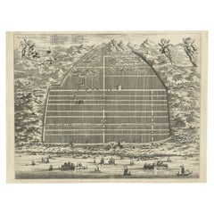
$1,041 Sale Price
20% Off
Free Shipping
The Principality of Dombes: A 17th-Century Cartographic Jewel by Jan Jansson
Located in Langweer, NL
The text on the map "La principaute de Dombes; J. van den Eynde sculpit.; La Principavte de Dombes" indicates that it is a map of the principality of Dombes, engraved by J. van den E...
Category
Antique 1630s Maps
Materials
Paper
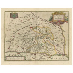
$530 Sale Price
20% Off
Free Shipping
More Ways To Browse
Woven Sling Chair
Wrought Iron Curule Bench
Yellow Ware Seaweed
Yoruba Textile
Yugoslavian Dining Chairs
Zeppelin Airship
10 Cab Chairs
108 Inch Dining Room Table
15 Ft Runner
1770 English Chair
17th Century Cane Chairs
17th Century Dutch Picture Frame
18th Century Oak Refectory Table
18th Century Salon Suite
1900 Bar Cart
1900s Bureau
1930s Birmingham Silver
1930s Upholstery Loveseats