Items Similar to Early 20th c. England and Wales Perrier Motor Map c.1910


Want more images or videos?
Request additional images or videos from the seller
1 of 9
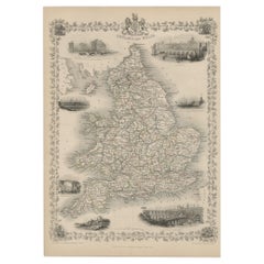
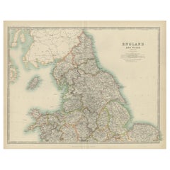
Early 20th c. England and Wales Perrier Motor Map c.1910
$275
£208.49
€240.33
CA$387.29
A$429.48
CHF 225.66
MX$5,247.51
NOK 2,823.31
SEK 2,650.16
DKK 1,794.12
About the Item
ABOUT
Large bright vivid color-printed Perrier Motor Map, featuring the motoring roads of England and Wales. Segmented in two sections and mounted to original linen back, folded into a cloth waterproof slipcase. Manufactured in London, circa 1910.
Perfect for framing. Scotland and Ireland also available.
CREATOR Perrier. London, U.K.
DATE OF MANUFACTURE c.1910.
MATERIALS AND TECHNIQUES Linen, Paper.
CONDITION Good. Wear consistent with age and use.
DIMENSIONS H 57 in. W 46.25 in. (open), Slipcase: 10.25 in. W 8.25 in. D .5 in.
HISTORY
Unknown.
- Dimensions:Height: 57 in (144.78 cm)Width: 46.25 in (117.48 cm)Depth: 0.25 in (6.35 mm)
- Style:Victorian (Of the Period)
- Materials and Techniques:
- Place of Origin:
- Period:
- Date of Manufacture:1910
- Condition:Wear consistent with age and use.
- Seller Location:San Francisco, CA
- Reference Number:Seller: Posters SKU 0521stDibs: LU1280240797102
About the Seller
5.0
Vetted Professional Seller
Every seller passes strict standards for authenticity and reliability
Established in 2014
1stDibs seller since 2015
1,332 sales on 1stDibs
Typical response time: 1 hour
- ShippingRetrieving quote...Shipping from: San Francisco, CA
- Return Policy
Authenticity Guarantee
In the unlikely event there’s an issue with an item’s authenticity, contact us within 1 year for a full refund. DetailsMoney-Back Guarantee
If your item is not as described, is damaged in transit, or does not arrive, contact us within 7 days for a full refund. Details24-Hour Cancellation
You have a 24-hour grace period in which to reconsider your purchase, with no questions asked.Vetted Professional Sellers
Our world-class sellers must adhere to strict standards for service and quality, maintaining the integrity of our listings.Price-Match Guarantee
If you find that a seller listed the same item for a lower price elsewhere, we’ll match it.Trusted Global Delivery
Our best-in-class carrier network provides specialized shipping options worldwide, including custom delivery.More From This Seller
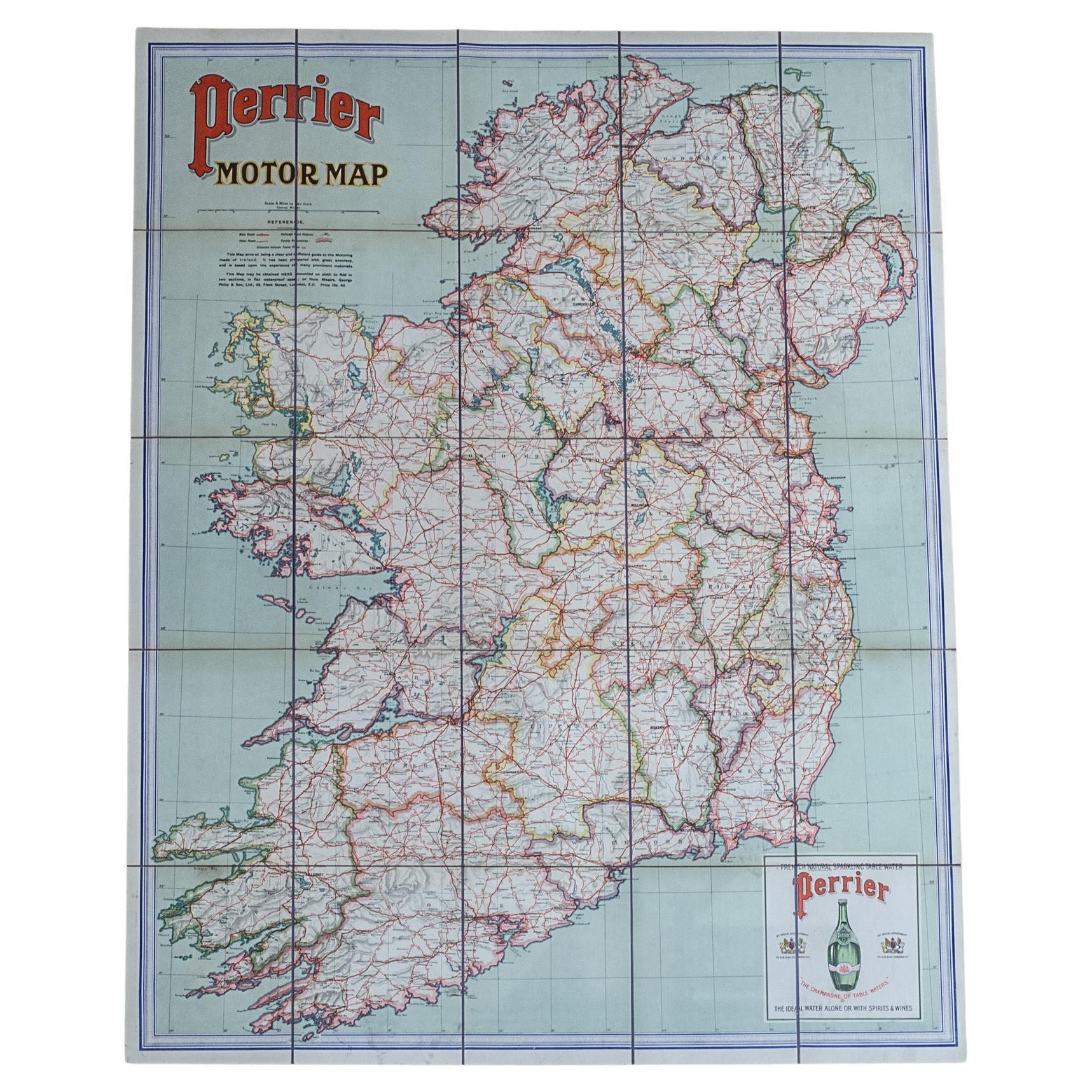
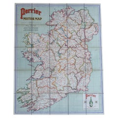
View AllEarly 20th c. Ireland Perrier Motor Map c.1910
Located in San Francisco, CA
ABOUT
Large bright vivid color-printed Perrier Motor Map, featuring the motoring roads of Ireland. Mounted to original linen back, folded into a cloth waterproof slipcase. Manufactu...
Category
Early 20th Century British Victorian Globes
Materials
Linen, Paper
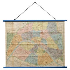
Early 20th c. Plan of Paris Map Hanging Scroll c.1920
Located in San Francisco, CA
ABOUT
An original folding map of the Paris on two dowels and hanging chain. Linen backed.
CREATOR France by L. Guilmin. Paris, France.
DATE OF MANUFACTURE c.1920.
MAT...
Category
Early 20th Century French Art Deco Decorative Art
Materials
Wood, Paper, Linen
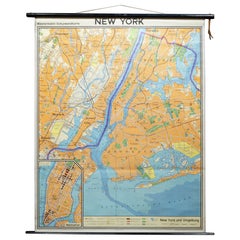
Mid-century German School Wall Map New York City and Vicinity Map c.1962
Located in San Francisco, CA
ABOUT
A mid-century school wall map of NYC and vicinity map in German. Linen backed mounted on two thick black dowels with leather strap.
CREATOR Kartographic und Druck: Georg...
Category
Mid-20th Century German Mid-Century Modern Decorative Art
Materials
Wood, Paper, Linen
19th-Early 20th c. Framed Surgical Instruments Lithographs
Located in San Francisco, CA
ABOUT
A pair of original lithographs of surgical instruments for lithotomy. The artwork has been framed with grey matte.
CREATOR Engraved ...
Category
Antique 19th Century American Victorian Prints
Materials
Paper
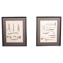
$76 Sale Price
27% Off
Original Restored Lithograph SNCF French Rail Travel Poster, Languedoc c.1956
Located in San Francisco, CA
ABOUT
Original restored SNCF French lithograph rail travel poster and linen backed.
CREATOR Artist: Jean Jules Louis Cavailles (1901 - 1977). Printer: Perceval, Paris.
DAT...
Category
Mid-20th Century French Mid-Century Modern Posters
Materials
Linen, Paper
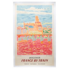
$995 Sale Price
23% Off
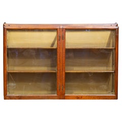
19th/Early 20th c. Mercantile Wall Mount Cabinet c.1880-1920
Located in San Francisco, CA
ABOUT
An antique Oak mercantile wall mount cabinet, possibly a ribbon cabinet or apothecary cabinet. Two large doors with original wavy glass that latc...
Category
Antique Late 19th Century American Victorian Cabinets
Materials
Glass, Oak
You May Also Like
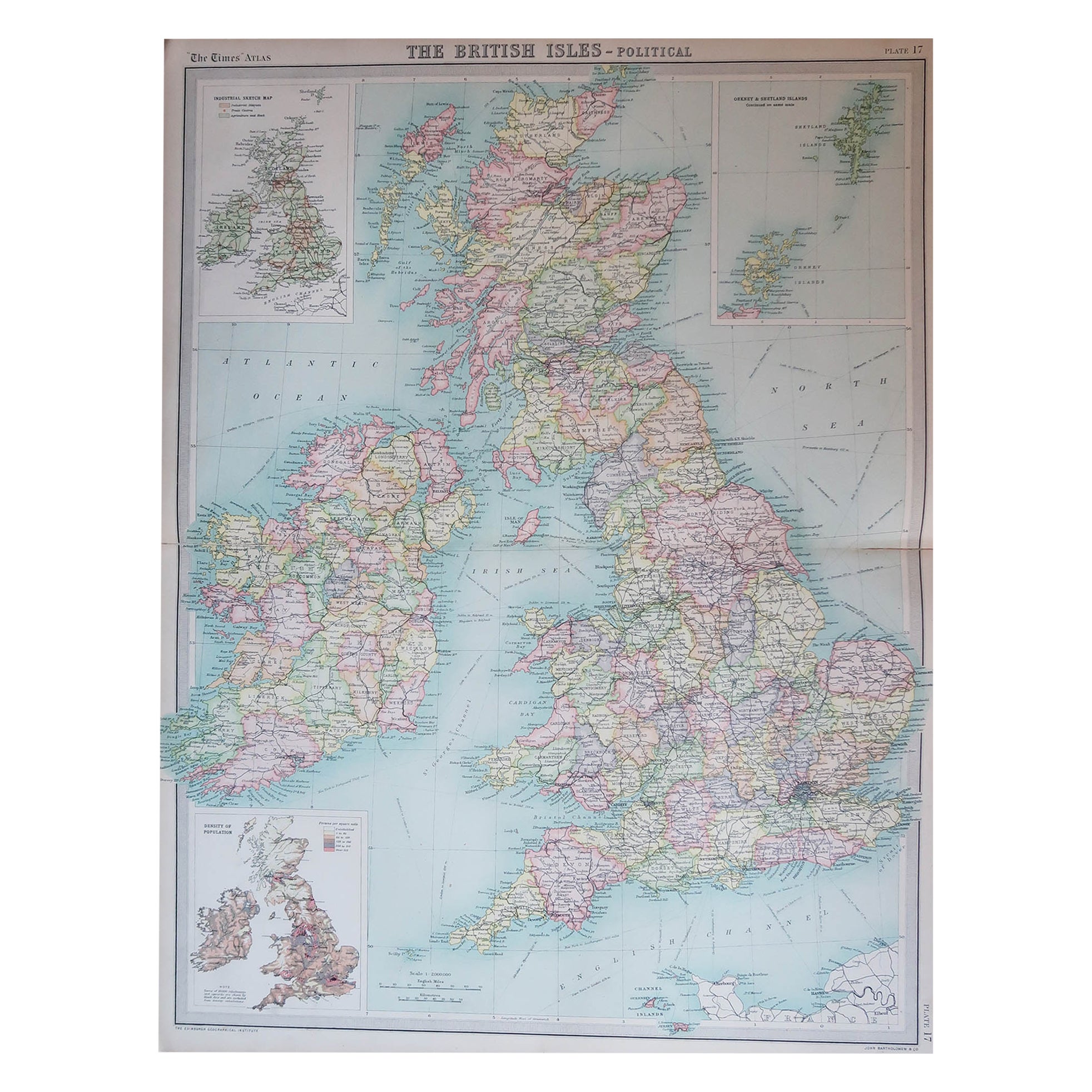
Large Original Vintage Map of the United Kingdom, circa 1920
Located in St Annes, Lancashire
Great map of The United Kingdom
Unframed
Original color
By John Bartholomew and Co. Edinburgh Geographical Institute
Published, circa 1920
Free shipping.
Category
Vintage 1920s British Maps
Materials
Paper

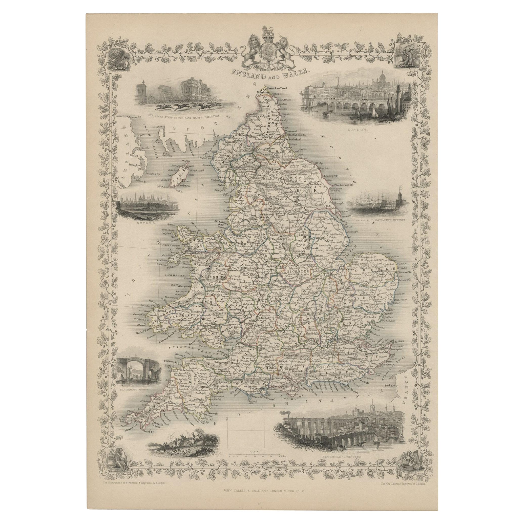
Antique Map of England and Wales with Decorative Vignettes, 1851
Located in Langweer, NL
Antique map titled ‘England and Wales’. Includes decorative vignettes titled The grand stand on the race ground Doncaster, London, Oxford, Entrance to Portsmouth Harbour, Sunderland ...
Category
Antique 19th Century Maps
Materials
Paper
$428 Sale Price
20% Off
Antique Map of, Northern England and Wales by Johnston, 1882
Located in Langweer, NL
Antique map titled 'England and Wales'.
Old map of England and Wales. This map originates from 'The Royal Atlas of Modern Geography, Exhibiting, in a Series of Entirely Original an...
Category
Antique 19th Century Maps
Materials
Paper

Antique Map of England and Wales by Johnston, 1882
Located in Langweer, NL
Antique map titled 'England and Wales'. Old map of England and Wales, with an inset map of Scilly Islands. This map originates from 'The Royal Atlas of Modern Geography, Exhibiting, ...
Category
Antique 19th Century Maps
Materials
Paper

$136 Sale Price
20% Off
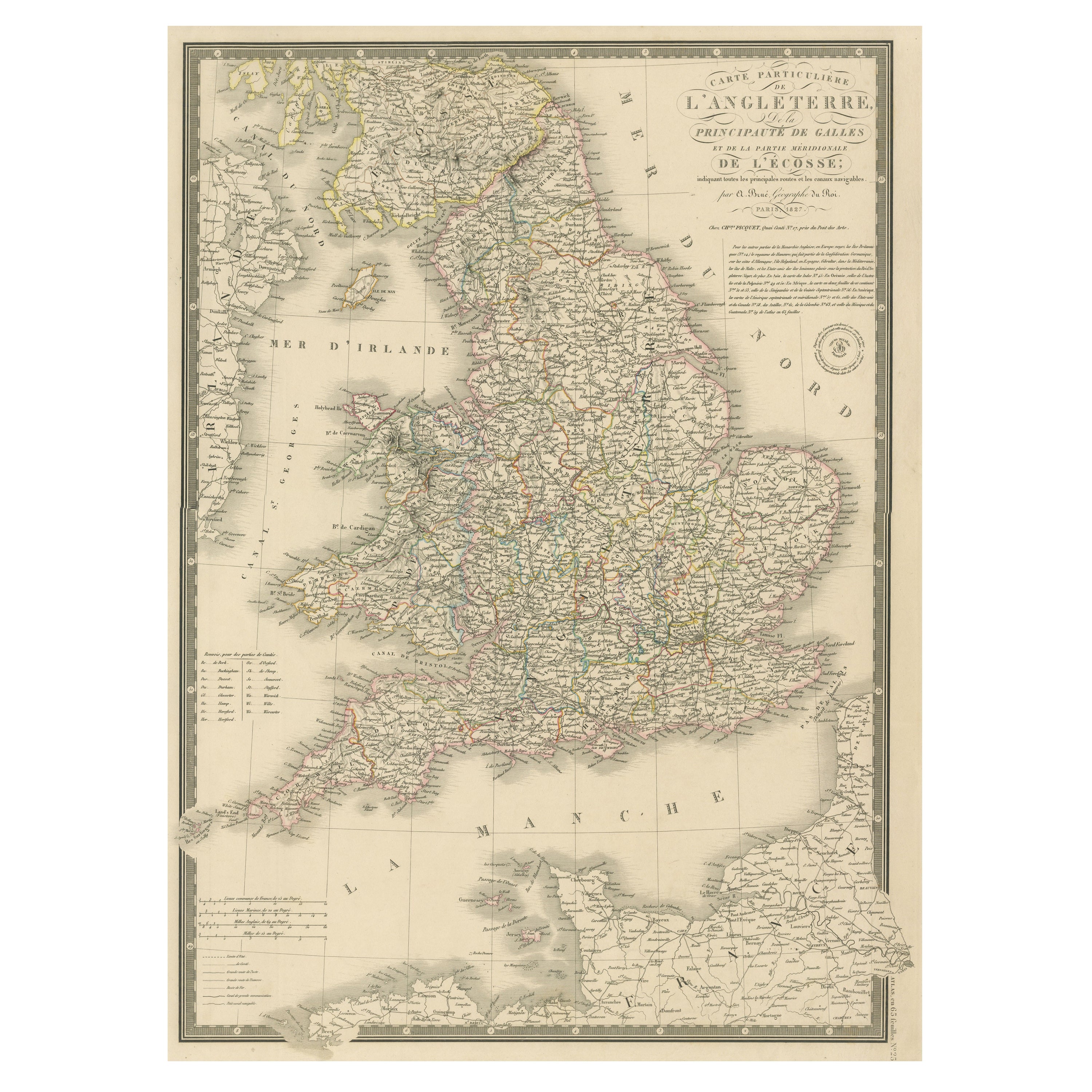
Antique Map of the British Isles and Part of the Coast of France
Located in Langweer, NL
Antique map titled 'Carte Particuliere l'Angleterre (..)'. Original antique map of the British Isles and part of the coast of France. It shows England and part of Wales. Published by...
Category
Antique Mid-19th Century Maps
Materials
Paper
$219 Sale Price
20% Off
Original Antique Map of England and Wales from the 1909 Royal Atlas
Located in Langweer, NL
The antique map titled 'England and Wales' is a historical cartographic representation of these two nations. This original antique map of England...
Category
Early 20th Century Maps
Materials
Paper
$238 Sale Price
20% Off
More Ways To Browse
Wales And Wales Furniture
Antique Linen Paper
J Didier
Desktop Globe
Bellerby Globe
Floor Globes By Replogle
Jro Globe
Weber Costello Globe
Weber Costello
Pearsall Globe
Rand Mcnally Terrestrial Globe
Adrian Pearsall Globe
Arthur Krause
Denoyer Geppert Globe
Repogle Globe
Denoyer Geppert Chalk Globe
Globus Table
Gustav Brueckmann