Items Similar to Antique Chart of Celestial and Scientific Models by Lapie, 1842


Want more images or videos?
Request additional images or videos from the seller
1 of 10
Antique Chart of Celestial and Scientific Models by Lapie, 1842
$711.36
$948.4825% Off
£532.37
£709.8325% Off
€600
€80025% Off
CA$981.38
CA$1,308.5125% Off
A$1,091.33
A$1,455.1125% Off
CHF 573.19
CHF 764.2625% Off
MX$13,342.66
MX$17,790.2225% Off
NOK 7,142.53
NOK 9,523.3725% Off
SEK 6,733.48
SEK 8,977.9725% Off
DKK 4,567.50
DKK 6,09025% Off
About the Item
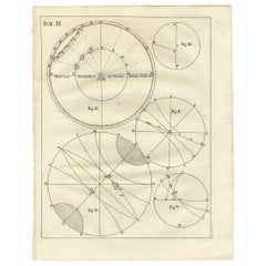
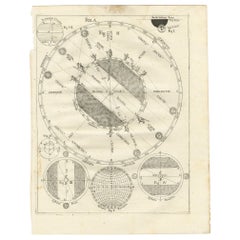
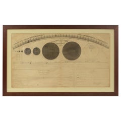
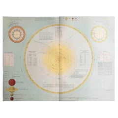
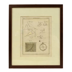
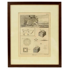
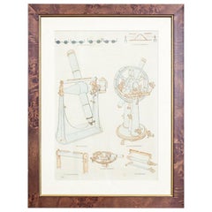
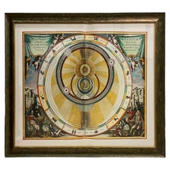
Antique print titled 'Systèmes Planétaires'. Chart of various celestial and scientific models. Includes an armillary sphere and various models of the universe, the season, eclipses, a Copernican, Tycho-Brahe and Ptolomaic model of the solar system and other models. This print originates from 'Atlas universel de géographie ancienne et moderne (..)' by Pierre M. Lapie and Alexandre E. Lapie. Pierre M. Lapie was a French cartographer and engraver. He was the father of cartographer Alexandre Emile Lapie.
- Dimensions:Height: 19.89 in (50.5 cm)Width: 26.78 in (68 cm)Depth: 0.02 in (0.5 mm)
- Materials and Techniques:
- Place of Origin:
- Period:
- Date of Manufacture:1842
- Condition:General age-related toning, original folding line. Blank verso, please study images carefully.
- Seller Location:Langweer, NL
- Reference Number:Seller: BG-12338-11stDibs: LU3054319603692
About the Seller
5.0
Recognized Seller
These prestigious sellers are industry leaders and represent the highest echelon for item quality and design.
Platinum Seller
Premium sellers with a 4.7+ rating and 24-hour response times
Established in 2009
1stDibs seller since 2017
2,609 sales on 1stDibs
Typical response time: <1 hour
- ShippingRetrieving quote...Shipping from: Langweer, Netherlands
- Return Policy
Authenticity Guarantee
In the unlikely event there’s an issue with an item’s authenticity, contact us within 1 year for a full refund. DetailsMoney-Back Guarantee
If your item is not as described, is damaged in transit, or does not arrive, contact us within 7 days for a full refund. Details24-Hour Cancellation
You have a 24-hour grace period in which to reconsider your purchase, with no questions asked.Vetted Professional Sellers
Our world-class sellers must adhere to strict standards for service and quality, maintaining the integrity of our listings.Price-Match Guarantee
If you find that a seller listed the same item for a lower price elsewhere, we’ll match it.Trusted Global Delivery
Our best-in-class carrier network provides specialized shipping options worldwide, including custom delivery.More From This Seller
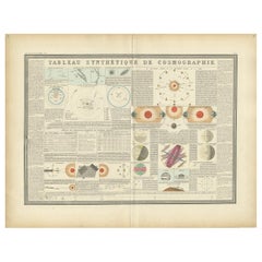
View AllAntique Print of the Planetary Systems of the World by Levasseur, '1875'
Located in Langweer, NL
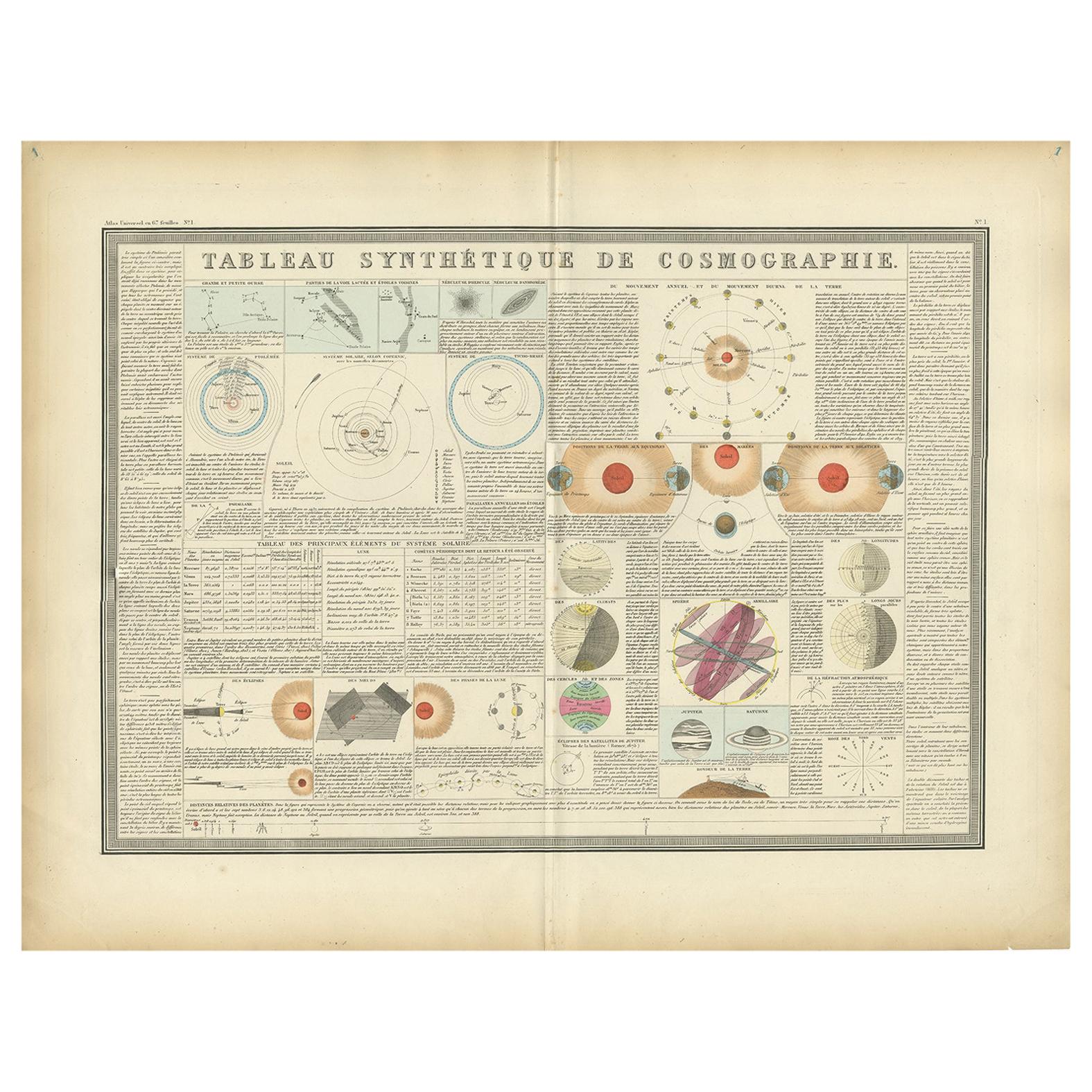
Antique print titled 'Tableau Synthétique de Cosmographie'. Large print depicting the planetary systems of the world. This map originates from 'Atlas de Géographie Moderne Physique e...
Category
Antique Late 19th Century Prints
Materials
Paper
$474 Sale Price
20% Off
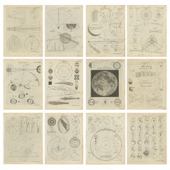
Set of 12 Antique Astronomy Prints by Bell 'c.1797'
Located in Langweer, NL
Set of twelve antique astronomy prints. Published 1787-1797 for 'Encyclopaedia Britannica'. Engraved by A. Bell.
Category
Antique Late 18th Century Prints
Materials
Paper
$948 Sale Price / set
20% Off
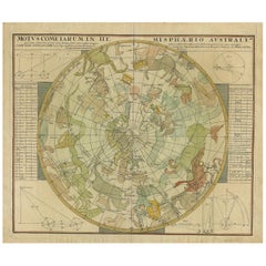
Antique Chart of the Passage of Comets in the Southern Sky, circa 1740
Located in Langweer, NL
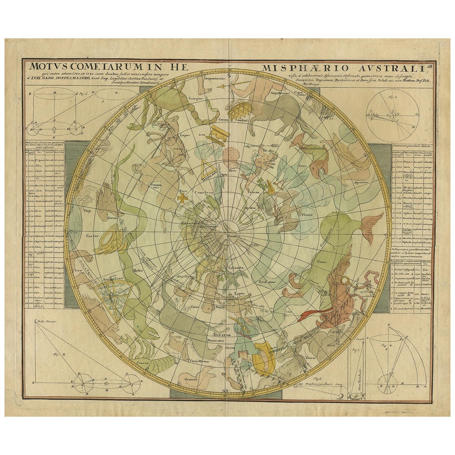
Antique map titled 'Motus Comtarum in Hemispaerio Australi (..)'. This uncommon chart depicts the passage of comets in the southern sky between the years 1530-1704. Centered on the ecliptic poles and shows the constellation figures based on classical mythology, without showing the stars. The paths of dozens of comets are illustrated, eincluding those sighted by Tycho Brahe...
Category
Antique Mid-18th Century Maps
Materials
Paper
$2,222 Sale Price
25% Off
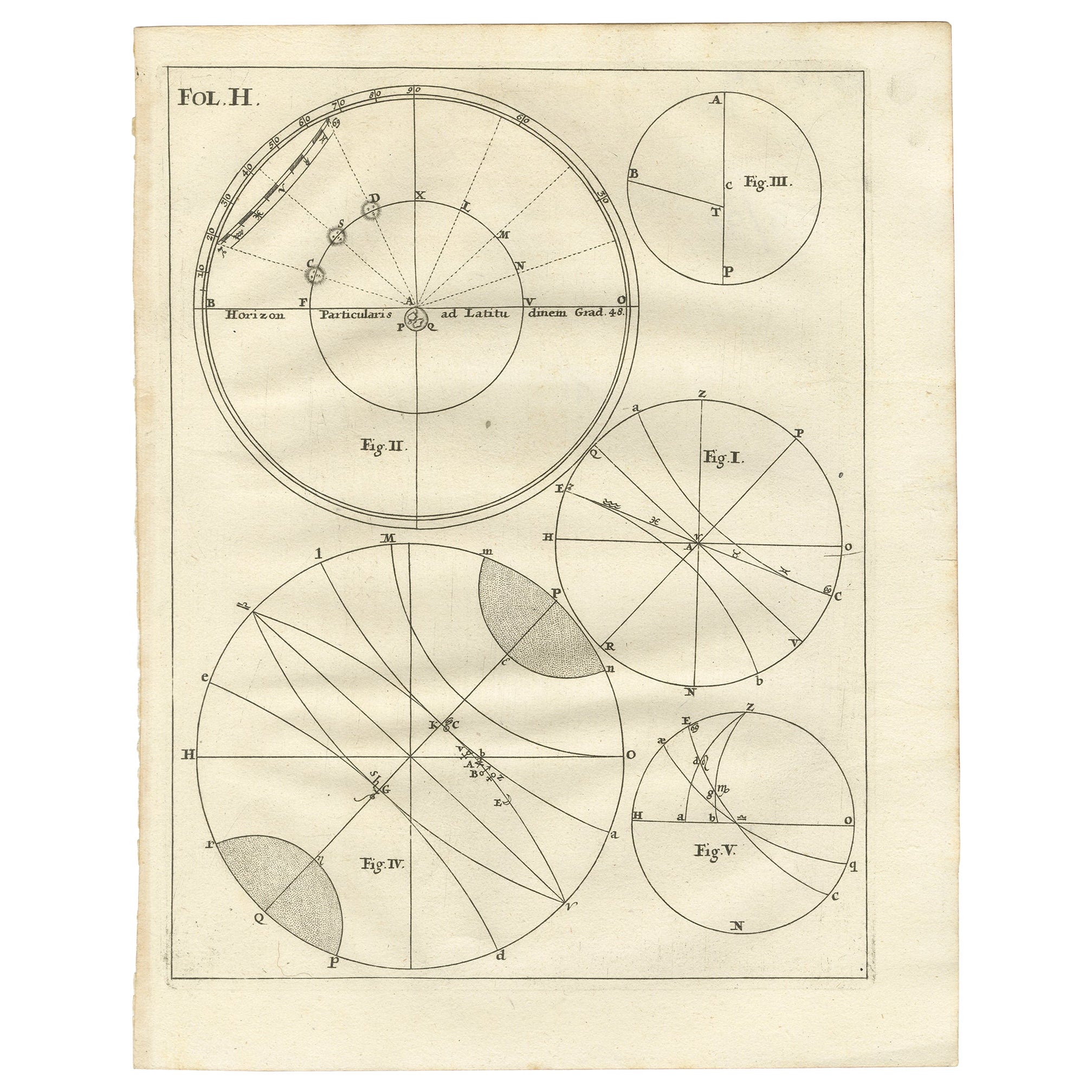
Antique Print with Charts of Hemispheres by Scherer, c.1703
Located in Langweer, NL
Various antique charts of hemispheres illustrating the positioning of the earth. Printed for Scherer's 'Atlas Novus' (1702-1710).
Artists and Engravers: Heinrich Scherer (1628-1704) was a Professor of Hebrew, Mathematics and Ethics at the University of Dillingen until about 1680. Thereafter he obtained important positions as Official Tutor to the Royal Princes...
Category
Antique 18th Century Prints
Materials
Paper
$227 Sale Price
20% Off
Antique Print with Various Antique Figures of Hemispheres by Scherer, c.1703
Located in Langweer, NL
Various antique figures of hemispheres illustrating the positioning of the earth. Printed for Scherer's 'Atlas Novus' (1702-1710).
Artists and Engravers: Heinrich Scherer (1628-1704) was a Professor of Hebrew, Mathematics and Ethics at the University of Dillingen until about 1680. Thereafter he obtained important positions as Official Tutor to the Royal Princes...
Category
Antique 18th Century Prints
Materials
Paper
$208 Sale Price
20% Off
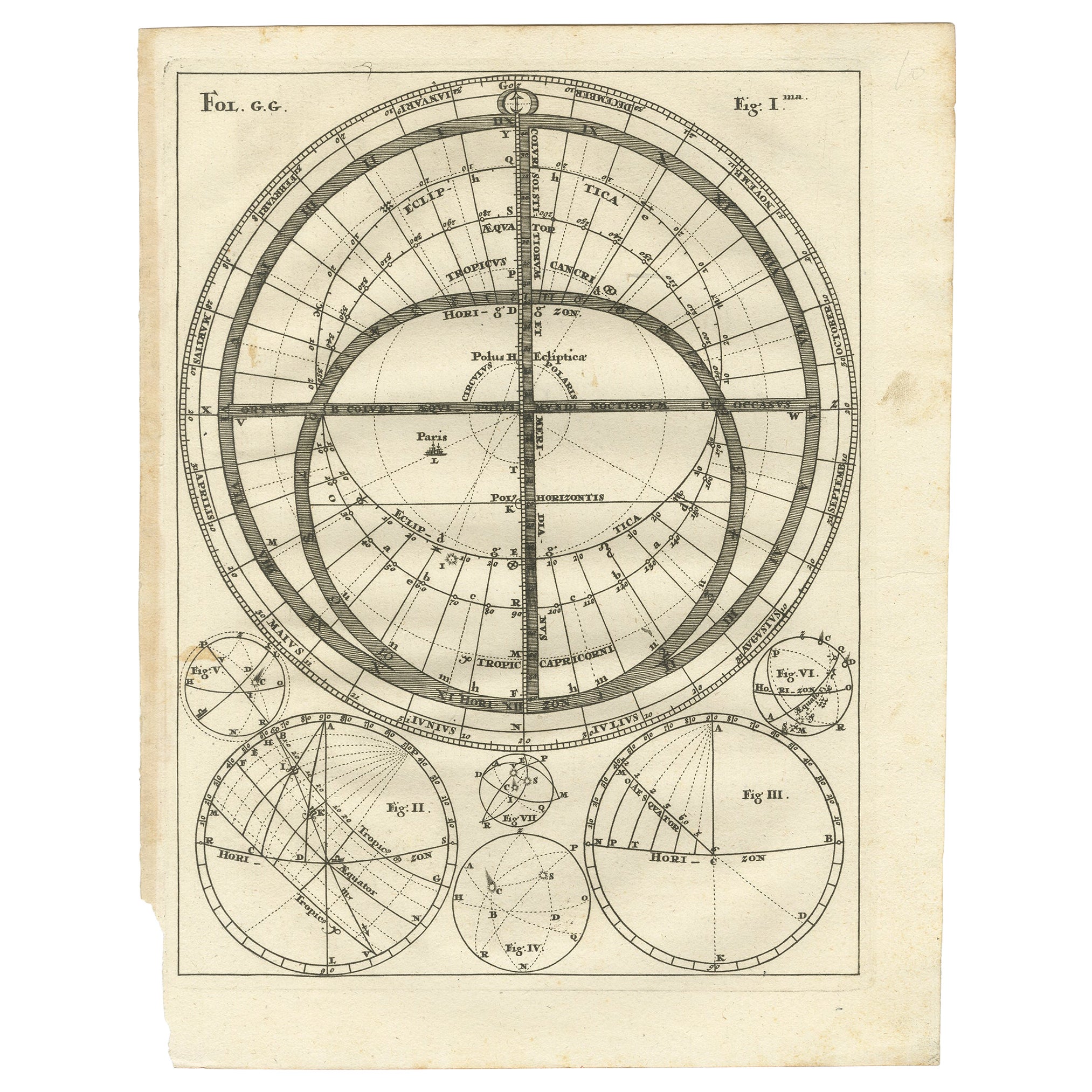
Antique Map Illustrating Solar Eclipses by Scherer, C.1703
Located in Langweer, NL
Antique map of an hemisphere and several figures illustrating the position of the earth, moon and sun. Printed for Scherer's 'Atlas Novus' (1702-1710).
Artists and Engravers: Heinrich Scherer (1628-1704) was a Professor of Hebrew, Mathematics and Ethics at the University of Dillingen until about 1680. Thereafter he obtained important positions as Official Tutor to the Royal Princes...
Category
Antique 18th Century Maps
Materials
Paper
$208 Sale Price
20% Off
You May Also Like
1855 Astronomical Plate of Distance of the Planets by FJ Huntington New York
Located in Milan, IT
Plate of the distance of the planets “Entered according to Act of Congress in the year 1855 by F.J. Huntington in the Clerk's Office of the District Court of the United States for th...
Category
Antique 1850s American Scientific Instruments
Materials
Glass, Wood, Paper
Original Antique Astronomy Print. C.1900
Located in St Annes, Lancashire
Great image of the solar system
Unframed.
Chromo-lithograph
Published, C.1900
The measurement is the paper size of the print
Free shipping.
Category
Antique Early 1900s English Folk Art Prints
Materials
Paper
Engraving on Copper Print from the Volume Navigazione Nautical Subject 1790
Located in Milan, IT
Print by engraving on copper plate Tav III TIX fig. 17-22 from the volume Navigazione; with frame 28 x 33. Some calculations are depicted. Very good condition.
Shipping is insured by...
Category
Antique 1790s Italian Nautical Objects
Materials
Paper
Engraving Print from the Panckoucke Encyclopédie Nautical Subject 1782-1832
Located in Milan, IT
Print by engraving on copper plate from the Panckoucke Encyclopédie méthodique, end of the 18th century, volume Marine Planches (more than 1,500 figures dealing with all subjects on ...
Category
Antique 1790s French Nautical Objects
Materials
Paper
20th Century Colorful Print in Frame Depicting Telescopes
Located in Opole, PL
20th Century Colorful Print in Frame Depicting Telescopes
One of the items from the series of several illustrations on different topics.
The engraving...
Category
20th Century European Prints
Materials
Paper
$130 Sale Price
44% Off
Italian Renaissance Style Framed Print Of A Celestial Map "Tychonic Planisphere"
Located in Queens, NY
Italian Renaissance style framed print of a celestial map depicting the beliefs of the Earth is stationary at the center of the planetary system with the Sun and Moon revolving the E...
Category
20th Century Italian Renaissance Paintings
Materials
Brass
More Ways To Browse
Celestial Sphere
Antique Armillary Sphere
Antique Solar System
H Alken
Herculaneum Engraving
Ivory Triptych
Loon Bird
Antique Anatomical Charts
Antique Bison
Antique Citrus Prints
Ceremonial Vignette
Dior Vargas
Fox Hunt Engraving
Japanese Prints Of Horses
Otto Eerelman
Rene Descartes
Antique Quaker Furniture
Chinese Cigarette Poster