Items Similar to Antique Engravings of Japan incl a Map and the Arrival of the Dutch, 1732


Want more images or videos?
Request additional images or videos from the seller
1 of 10
Antique Engravings of Japan incl a Map and the Arrival of the Dutch, 1732
$574.50
$897.6536% Off
£423.78
£662.1636% Off
€480
€75036% Off
CA$795.99
CA$1,243.7436% Off
A$864.29
A$1,350.4636% Off
CHF 457.71
CHF 715.1736% Off
MX$10,593.78
MX$16,552.7836% Off
NOK 5,664.31
NOK 8,850.4836% Off
SEK 5,352.47
SEK 8,363.2436% Off
DKK 3,654.17
DKK 5,709.6536% Off
About the Item
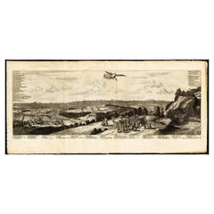
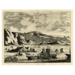
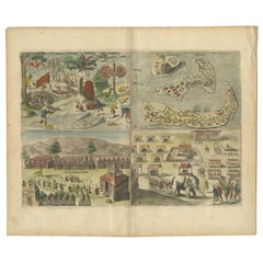
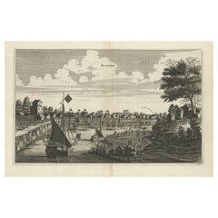
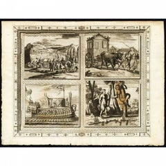
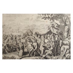
Original antique print titled 'Succession des Empereurs du Japon avec une Description de Meurtre de l'Empereur Cubo et la Reception des Ambassadeurs Hollandois en ce Pays la'. It shows: a central table of the succession of Japanese Emperors, a map of (part of modern-day) Japan, and two engravings: the death of Cubo, and the Dutch ambassador's arrival in Japan. The 2 engravings derived from Montanus: the murder of Emperor Cubo in a rebellion in 1564 and the arrival of Dutch Ambassadors in Japan 1644. This original old antique print / plate originates from the fifth volume of: 'Atlas Historique...' (Historic Atlas...), Published by Zacharie Chatelain, Amsterdam, 1732. The atlas was published in seven volumes between 1705 and 1720, with a second edition appearing in 1732. The maps were accompanied by information pertaining to cosmography, geography, history, chronology, genealogy, topography, heraldry, and costumes of the world. The maps in the Atlas Historique were mainly based on those of the French cartographer, Guillaume De L'Isle, but were presented by the Chatelains in an encyclopaedic form. We do not know the exact edition of this map.
When formal trade relations were established in 1609 by requests from Englishman William Adams, the Dutch were granted extensive trading rights and set up a Dutch East India Company trading outpost at Hirado. They traded exotic Asian goods such as spices, textiles, porcelain, and silk. When the Shimabara uprising of 1637 happened, in which Christian Japanese started a rebellion against the Tokugawa shogunate, it was crushed with the help of the Dutch. As a result, all Christian nations who gave aid to the rebels were expelled, leaving the Dutch the only commercial partner from the West. Among the expelled nations was Portugal who had a trading post in Nagasaki harbor on an artificial island called Dejima. In a move of the shogunate to take the Dutch trade away from the Hirado clan, the entire Dutch trading post was moved to Dejima. Dejima (Japanese: ??, "exit island") was a Portuguese and subsequently Dutch trading post at Nagasaki, Japan, from 1634 to 1854. Dejima was also the location for trade with the Chinese at the time, and thus the only place designated for foreign trade and exchange during the historical Japanese Edo period. (Source: Wikipedia)
Artists and Engravers: Henri Abraham Chatelain (1684-1743), his father Zacharie Chatelain (d.1723) and Zacharie Junior (1690-1754), worked as a partnership publishing the Atlas Historique, Ou Nouvelle Introduction A L'Histoire under several different Chatelain imprints, depending on the Chatelain family partnerships at the time of publication.
Condition: Very good, given age. Original folds from binding with some paper separation at lower fold all backed and restored. General age-related light toning and minimal staining from handling. Some creasing. Paper edges a bit irregular as issued and with ocassional chipping. Please study image carefully.
Date: 1732
Overall size: 47.5 x 42.5 cm.
Image size: 44.5 x 38.5 cm.
We sell original antique maps to collectors, historians, educators and interior decorators all over the world. Our collection includes a wide range of authentic antique maps from the 16th to the 20th centuries. Buying and collecting antique maps is a tradition that goes back hundreds of years. Antique maps have proved a richly rewarding investment over the past decade, thanks to a growing appreciation of their unique historical appeal. Today the decorative qualities of antique maps are widely recognized by interior designers who appreciate their beauty and design flexibility. Depending on the individual map, presentation, and context, a rare or antique map can be modern, traditional, abstract, figurative, serious or whimsical. We offer a wide range of authentic antique maps for any budget.
- Dimensions:Height: 16.74 in (42.5 cm)Width: 18.71 in (47.5 cm)Depth: 0 in (0.01 mm)
- Materials and Techniques:Paper,Engraved
- Place of Origin:
- Period:
- Date of Manufacture:1732
- Condition:Very good, given age. Original folds from binding with some paper separation at lower fold all backed and restored. General age-related light toning and minimal staining from handling. Some creasing.
- Seller Location:Langweer, NL
- Reference Number:Seller: PCT-404001stDibs: LU3054325991542
About the Seller
5.0
Recognized Seller
These prestigious sellers are industry leaders and represent the highest echelon for item quality and design.
Platinum Seller
Premium sellers with a 4.7+ rating and 24-hour response times
Established in 2009
1stDibs seller since 2017
2,623 sales on 1stDibs
Typical response time: <1 hour
- ShippingRetrieving quote...Shipping from: Langweer, Netherlands
- Return Policy
Authenticity Guarantee
In the unlikely event there’s an issue with an item’s authenticity, contact us within 1 year for a full refund. DetailsMoney-Back Guarantee
If your item is not as described, is damaged in transit, or does not arrive, contact us within 7 days for a full refund. Details24-Hour Cancellation
You have a 24-hour grace period in which to reconsider your purchase, with no questions asked.Vetted Professional Sellers
Our world-class sellers must adhere to strict standards for service and quality, maintaining the integrity of our listings.Price-Match Guarantee
If you find that a seller listed the same item for a lower price elsewhere, we’ll match it.Trusted Global Delivery
Our best-in-class carrier network provides specialized shipping options worldwide, including custom delivery.More From This Seller
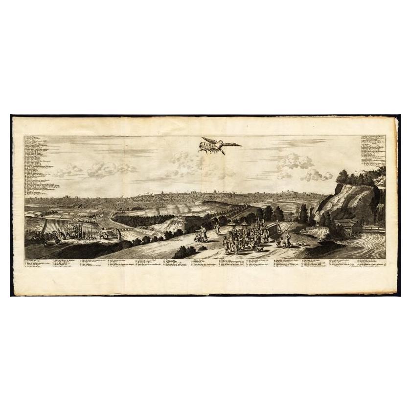
View AllAntique Print of Edo by Van Der Aa, circa 1725
By Pieter Van Der Aa
Located in Langweer, NL
Antique print titled 'Iedo, Capitale du Iapon.' View of Edo / Tokyo, capital of Japan. Extremely rare in this edition. This plate originates from the very scarse: 'La Galerie Agreabl...
Category
Antique 18th Century Prints
Materials
Paper
$947 Sale Price
20% Off
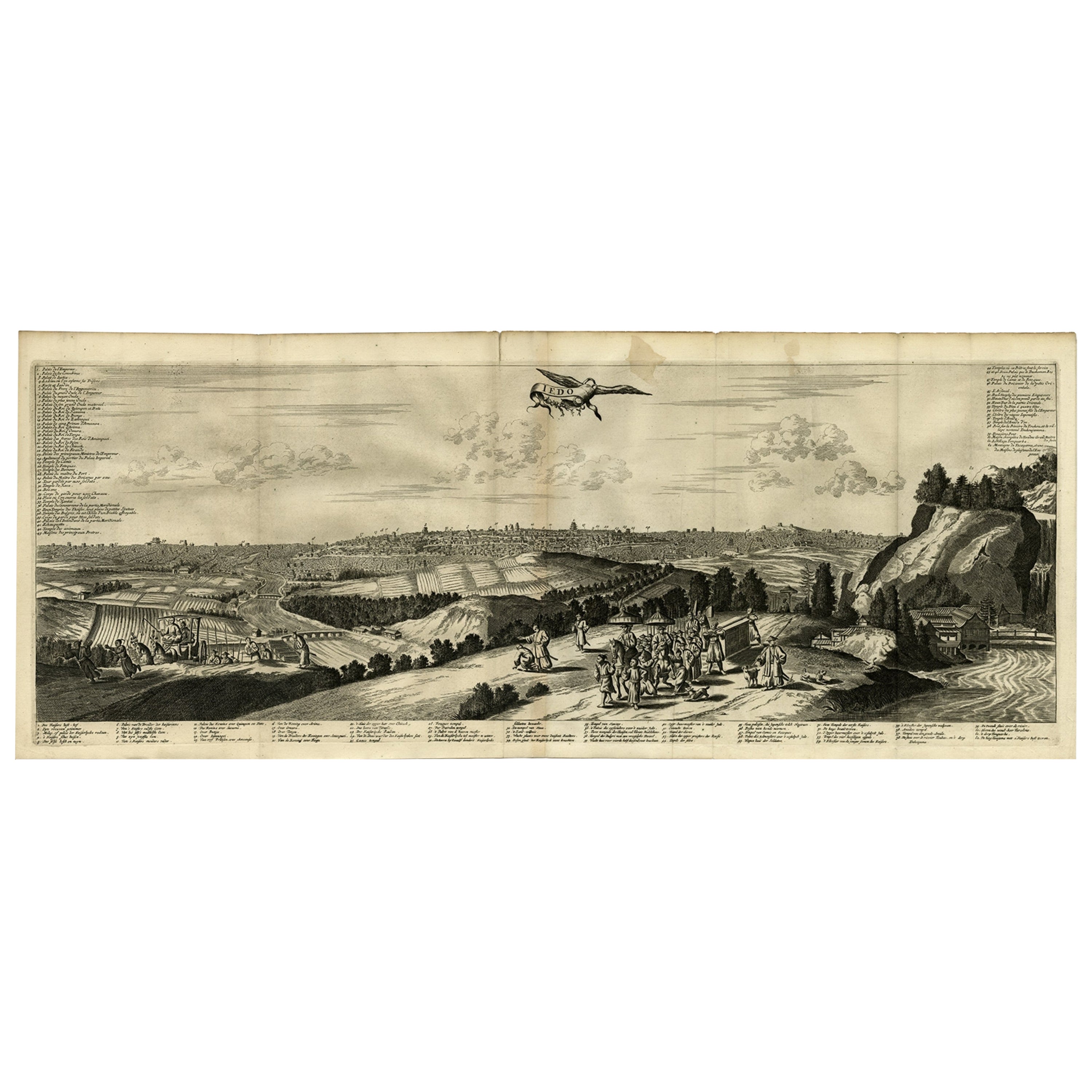
Antique Engraving of Edo 'or Jeddo, Yedo, Now Tokyo', 1669
Located in Langweer, NL
Antique print, titled: 'Iedo'
A bird's eye view of Edo (or Jeddo, Yedo, now Tokyo) as seen from a nearby hill. 62 places are identified in a list (both in French and Dutch). Arno...
Category
Antique 1660s Maps
Materials
Paper

$909 Sale Price
20% Off
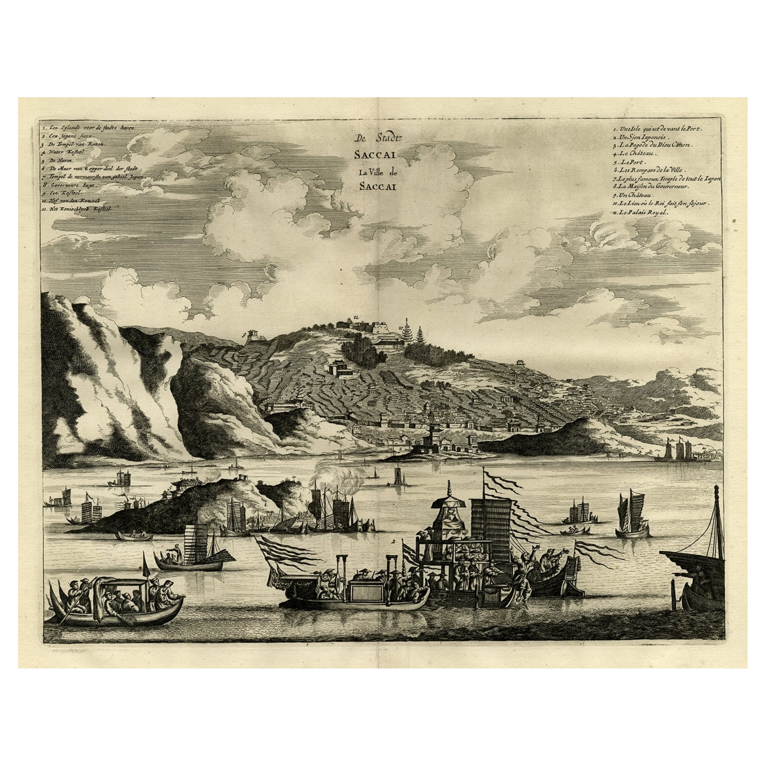
Original Antique Engraving of Sakai in the Osaka Prefecture, Japan, 1669
Located in Langweer, NL
Antique print, titled: 'De Stadt Saccai. La Ville de Saccai.' - ('The City Saccai').
This plate shows a view of Sakai in the Osaka Prefecture, Japan. Sakai has been one of the la...
Category
Antique 1660s Maps
Materials
Paper
$622 Sale Price
20% Off
Antique Engravings of Mauritius and Indonesia, incl de Banda Islands, c.1730
Located in Langweer, NL
Title on page: "Ins. de Cerno a. Nostatibus Mauritius Nominata [on sheet with] Gunnanappi Labetacq [and] Civitas Gammelamme [and] Rex Tubatus", Le Clerc, Jean
This sheet includes fo...
Category
Antique 1730s Maps
Materials
Paper
$526 Sale Price
20% Off
Antique Copper Engraving of the City of Kuchin in China, 1668
By Johannes Nieuhof
Located in Langweer, NL
Antique print China titled 'Kuching'.
Old print depicting a view on the Chinese city of Kuching or Kuchin (Gui Jiang, Kuei Chiang), near the river Gui (Guei). This area is close ...
Category
Antique 17th Century Prints
Materials
Paper
$325 Sale Price
20% Off
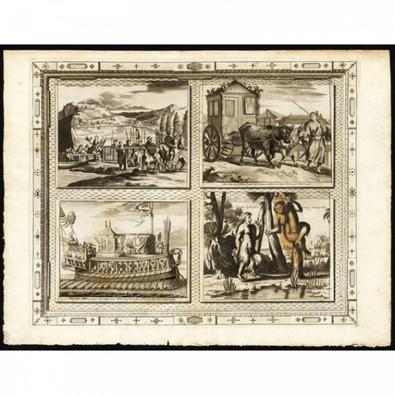
Antique Print with Four Japanese Views by Van Der Aa, 1725
Located in Langweer, NL
Antique print titled 'Japonais voyageant a cheval au litiere et dans leurs navires. - Chariot magnifiques pour les dames nobles du Japon tirez par des boeufs. - Fayfena ou Brigantin ...
Category
Antique 18th Century Prints
Materials
Paper
$517 Sale Price
20% Off
You May Also Like
Antique Voc Print Holland Malaysia Old Map Melaka History, 1663
Located in Amsterdam, Noord Holland
From my own collection I offer this impressive Antique print of the city of Malakka
A very interesting piece for collectors . It is an museum piece from the Dutch Institute of Orien...
Category
Antique 17th Century European Paintings
Materials
Paper

$293 Sale Price
20% Off
17th-18th Century Siege of Graves Mapping Engraving By Willian III
Located in Kingston, NY
RARE French 17th-18th Century Enhanced Siege of Graves Mapping Engraving BY William III, also widely known as William of Orange,
The Siege of Grave in Dutch Brabant started by Monsie...
Category
Antique 17th Century French Prints
Materials
Paper

Original Antique Print After Jan Luyken, Amsterdam, Genesis XXXI, 1724
Located in St Annes, Lancashire
Wonderful copper-plate engraving after Jan Luyken
Published by Marten Schagen, Amsterdam. 1724
Text on verso
The measurement given is the paper size.
Category
Antique 1720s Dutch Renaissance Prints
Materials
Paper
Magnae Tartariae - Etching by Frederick de Wit - 1680ca
By Frederick de Wit
Located in Roma, IT
This double-page etching with contemporary coloring, entitled Magnae Tartariae, was realized by the cartographer Frederick de Wit for the famous Atlas published in Amsterdam in ca. 1...
Category
1680s Modern Figurative Prints
Materials
Etching
Tabula Russia Vulgo Moscovia - Etching by Frederick de Wit - 1680ca
By Frederick de Wit
Located in Roma, IT
This double-page etching with contemporary coloring, entitled Tabula Russia vulgo Moscovia, was realized by the cartographer Frederick de Wit for the famous Atlas published in Amster...
Category
1680s Modern Figurative Prints
Materials
Etching
Accuratissima Totius Asiae Tabula - Etching by Frederick de Wit - 1680 ca
By Frederick de Wit
Located in Roma, IT
This double-page etching with contemporary coloring, entitled Accuratissima totius Asiae Tabula, was realized by the cartographer Frederick de Wit for the famous Atlas published in A...
Category
1680s Modern Figurative Prints
Materials
Etching

More Ways To Browse
East India Trading Company
Vintage Wall Registers
1940s French Prints
1961 Picasso Exhibition
Aaa Lithograph
Alexander Wilson Birds
Antique Painting Pompeii
Arman Boom Boom
Audubon Havell Edition
Audubon Havell
Aurelia In A Red Bonnet
Avi Kiriaty
Bernard Munch
Bjorn Wiinblad Lithograph
Botero Hand Signed
Calder Artist Proof
Carol Summers Vintage Prints
Chagall Circus Signed