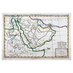
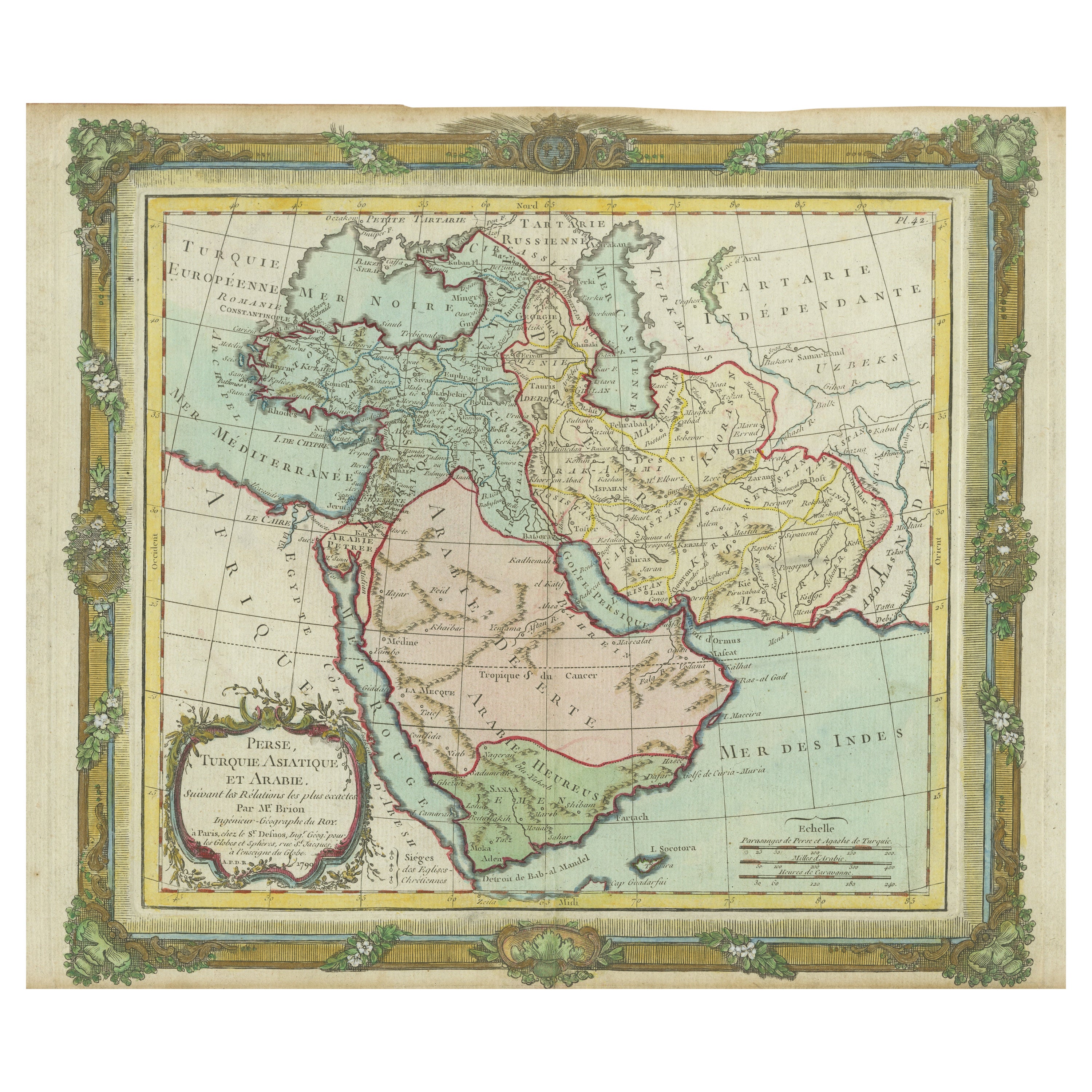
Bonne, Map of Middle East, Persia, Red Sea, Egypt, Nubia Hand Coloured
View Similar Items


Want more images or videos?
Request additional images or videos from the seller
1 of 6
Bonne, Map of Middle East, Persia, Red Sea, Egypt, Nubia Hand Coloured
About the Item
About the Seller
No Reviews Yet
Vetted Professional Seller
Every seller passes strict standards for authenticity and reliability
Established in 1992
1stDibs seller since 2022
10 sales on 1stDibs
Authenticity Guarantee
In the unlikely event there’s an issue with an item’s authenticity, contact us within 1 year for a full refund. DetailsMoney-Back Guarantee
If your item is not as described, is damaged in transit, or does not arrive, contact us within 7 days for a full refund. Details24-Hour Cancellation
You have a 24-hour grace period in which to reconsider your purchase, with no questions asked.Vetted Professional Sellers
Our world-class sellers must adhere to strict standards for service and quality, maintaining the integrity of our listings.Price-Match Guarantee
If you find that a seller listed the same item for a lower price elsewhere, we’ll match it.Trusted Global Delivery
Our best-in-class carrier network provides specialized shipping options worldwide, including custom delivery.More From This Seller
View AllOstrich, Oudart, Large Hand Coloured Stone Lithograph, Rare
Located in Norwich, GB
Autruche
Habits les deserts brulants de l’Afrique, court Alec use vitesse incroyable, et donne plumes du plus beau duvet.
Extremely rare.
Issued in the series:
Histoire naturelle. Ensemble de 41 planches dessinées par Guerin et Lith. en couleurs par E.F. Noel.
Published by Noel aîné, Paris, 1827.
Because the work was never formally completed no title-page nor accompanying letterpress for the series was produced, though the title 'Collection d'Animaux' appears in the publisher's 1827 catalogue of plates available for individual purchase (at a franc each, or 75 centimes uncoloured). The images were produced by Paul-Louis Oudart and P. Guerin, both noted as "dessinateurs-naturalistes" at the Jardin du Roi (the Jardin des Plantes...
Category
Antique 1820s French Prints
Materials
Paper
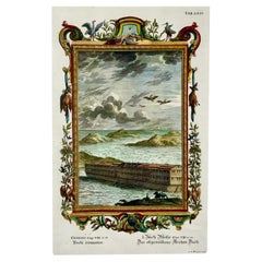
Joh. Jak. Scheuchzer, Bible Engraving, Noah’s Ark, Folio, Hand Coloured
Located in Norwich, GB
Johann Jakob Scheuchzer (1672-1733); engraved by P.A. Kilian.
Bible engraving, Noah’s Ark
Folio.
Dimensions: 38 x 24 cm.
Hand coloured
This fascinating folio engraving is from Johann Jakob Scheuchzer’s Physica Sacra. The work was published in Augsburg und Ulm between 1731 and 1735. Each engraving features highly decorative borders which feature biblical and scientific depictions.
Physica Sacra combined theological and scientific practices in an attempt to reconcile biblical passages with the new sciences of the time. The work is an extraordinary illustrated natural history work, and a great example of the decorative nature of the 18th century copper engraving.
Scheuchzer was a founder of paleobotany and European paleontology, as well as a professor of mathematics and physics. He believed the Old Testament was a factual account of the history of the world...
Category
Antique Early 18th Century German Prints
Materials
Paper
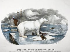
1827 Polar Bear, Mammal, Oudart, Large Hand Coloured Stone Lithograph, Rare
Located in Norwich, GB
Our Blanc de la Mer Glaciale
Tres remarquable par sa tete allongee, et sa blancher….
Dimensions: Height: 10.83 in (27.5 cm) Width: 14.57 in (37 cm)
Extremely rare.
Is...
Category
Antique 1820s French Prints
Materials
Paper
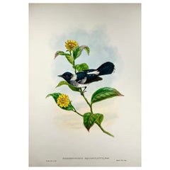
1888 Pied Flycatcher, John Gould 'B1804', Magnificent Hand Coloured Lithograph
Located in Norwich, GB
Gould, John and Richard Bowdler Sharpe.
The Birds of New Guinea and the Adjacent Papuan Islands.
Piezorhynchus Squalmulatus.
London, 1875-1888.
Paper Size:
380mm x 5...
Category
Antique 1880s English Victorian Prints
Materials
Paper
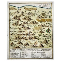
Map of Indonesia, Semarang, Kartasoera, Soerabaya by Schley
By Jakob van der Schley
Located in Norwich, GB
'Carte du Chemin entre Samarang et Cartasoera, kaart van den weg tusschen Samarang en Cartasoera'
Map of the Road between Semarang and Kartasura by Van Schley.
Published 1763.
...
Category
Antique 1760s Indonesian Georgian Prints
Materials
Paper
1750 Schaffhausen, Seutter, Large and Detailed Map Switzerland
By Matthew Seutter
Located in Norwich, GB
Sandrart Joachim, von (1606-1688)
Effigies antiquae Romae. redacta a Pyrrho Ligorio Romano, per XIIII Regiones, in quas Urbem divisit Imp. Caesar August.
Nuremberg, Germany, pu...
Category
Antique 1670s Italian Baroque Prints
Materials
Paper
You May Also Like
Antique Map of the East Indies by Bonne '1776'
Located in Langweer, NL
Antique map titled 'Indes IVe Feuille'. Very decorative original antique map of the East Indies. Covbers from the Gulf of Siam (Gulf of Thailand) and Malacca (Malaysia) eastward to i...
Category
Antique Late 18th Century Maps
Materials
Paper

$511 Sale Price
20% Off
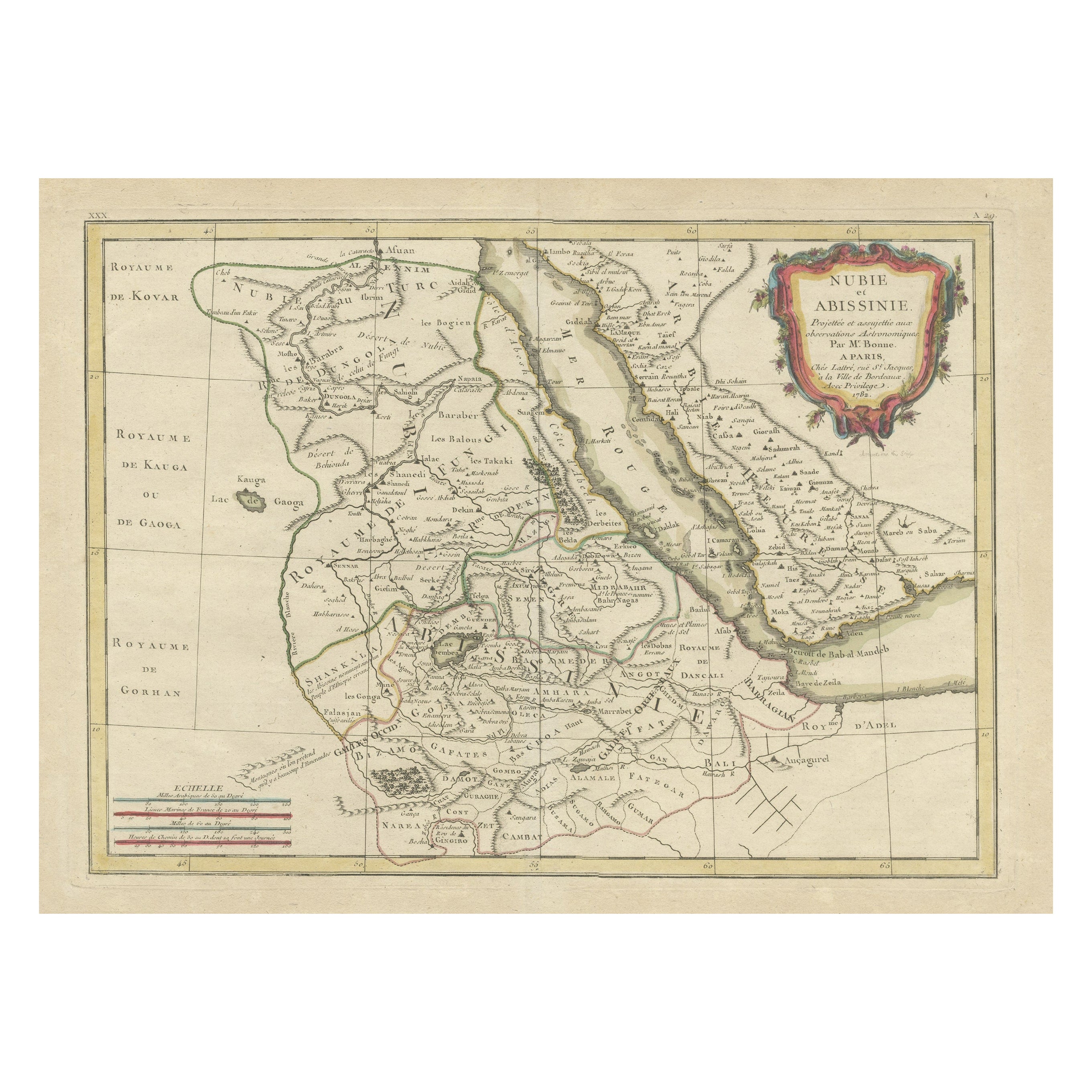
Antique Map of Arabia including Nubia and Abyssinia, also shows the Red Sea
Located in Langweer, NL
Antique map titled 'Nubie et Abissinie'. Original antique map of Nubia, a region along the Nile river, and Abyssinia or the Ethiopian Empire. This map o...
Category
Antique Late 18th Century Maps
Materials
Paper
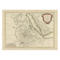
$800 Sale Price
20% Off
Antique Map of Egypt, Arabia Petraea and Lower Nubia by Johnston '1909'
Located in Langweer, NL
Antique map titled 'Egypt, Arabia Petraea and Lower Nubia'. Original antique map of Egypt, Arabia Petraea and Lower Nubia. With inset maps of Alexandriam Cairo and the Suez Canal...
Category
Early 20th Century Maps
Materials
Paper

$218 Sale Price
24% Off
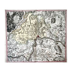
Rare Antique Map of the Middle East, ca.1690
Located in Langweer, NL
Description: Antique print, untitled.
Two decorative maps on one sheet of the middle east in biblical times. Source unknown, to be determined.
Artists and Engravers: Anonymous...
Category
Antique 1690s Prints
Materials
Paper

$334 Sale Price
20% Off
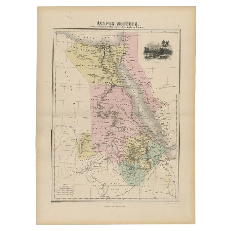
Antique Map of The Nile, Egypt, Nubia and Abyssinia and Inset of Jerusalem, 1880
Located in Langweer, NL
Antique map titled 'Égypte Moderne'. Old map of Egypt, Nubia and Abyssinia (Ethiopia), Kordofan and Darfour (parts of Sudan), as well as part of Arabia. With decorative vignette of J...
Category
Antique 19th Century Maps
Materials
Paper

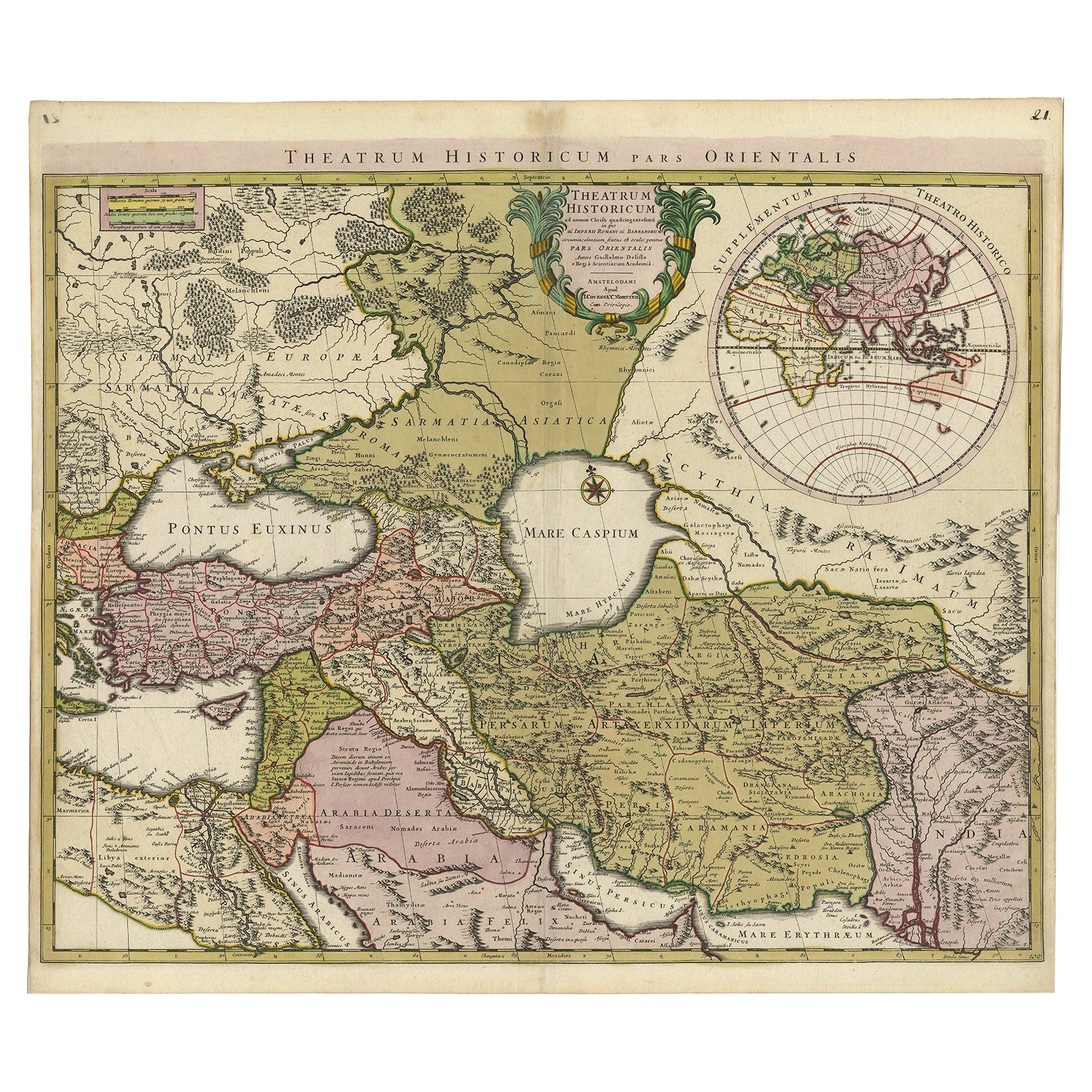
Finely Engraved Historical Map of Middle East and Asia, c.1745
Located in Langweer, NL
Description: Antique map titled'Theatrum Historicum pars Orientalis.'
Finely engraved historical map with a profusion of details. It shows the Middle East and Asia. Decorative ti...
Category
Antique 1740s Maps
Materials
Paper
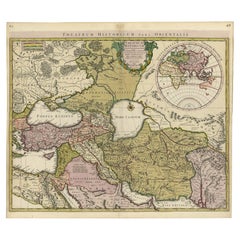
$1,349 Sale Price
20% Off