Items Similar to Finely Engraved Historical Map of Middle East and Asia, c.1745


Want more images or videos?
Request additional images or videos from the seller
1 of 5
Finely Engraved Historical Map of Middle East and Asia, c.1745
About the Item
Description: Antique map titled'Theatrum Historicum pars Orientalis.'
Finely engraved historical map with a profusion of details. It shows the Middle East and Asia. Decorative title cartouche and inset representing the Eastern hemisphere symmetrically shown in upper right corner. Published in Amsterdam by Covens & Mortier.
Artists and Engravers: Made by 'Guillaume de l'Isle' after an anonymous artist. The de L'Isle family was one of the most influential Geographers of the early 18th century in France. Claude de L'Isle, born 1644, had four sons, of which Guillaume was the most notable. Guillaume was born 1675 and became member of the "Academie Royale des Sciences" with the age of twenty-seven, and was honoured later with the title "Premier Geographe du Roi". His largest project, the "Atlas de Geographie", was published until 1774 in Paris and Amsterdam (Covens and Mortier). He died in 1726.
Condition: Good, given age. Edges reinforced on verso with acid free tape. Light vertical crease next to middle fold. Original middle fold as issued. General age-related toning and/or occasional minor defects from handling. Please study image carefully.
- Dimensions:Height: 21.26 in (54 cm)Width: 24.41 in (62 cm)Depth: 0 in (0.02 mm)
- Materials and Techniques:
- Period:1740-1749
- Date of Manufacture:circa 1745
- Condition:
- Seller Location:Langweer, NL
- Reference Number:
About the Seller
5.0
Platinum Seller
These expertly vetted sellers are 1stDibs' most experienced sellers and are rated highest by our customers.
Established in 2009
1stDibs seller since 2017
1,933 sales on 1stDibs
Typical response time: <1 hour
- ShippingRetrieving quote...Ships From: Langweer, Netherlands
- Return PolicyA return for this item may be initiated within 14 days of delivery.
More From This SellerView All
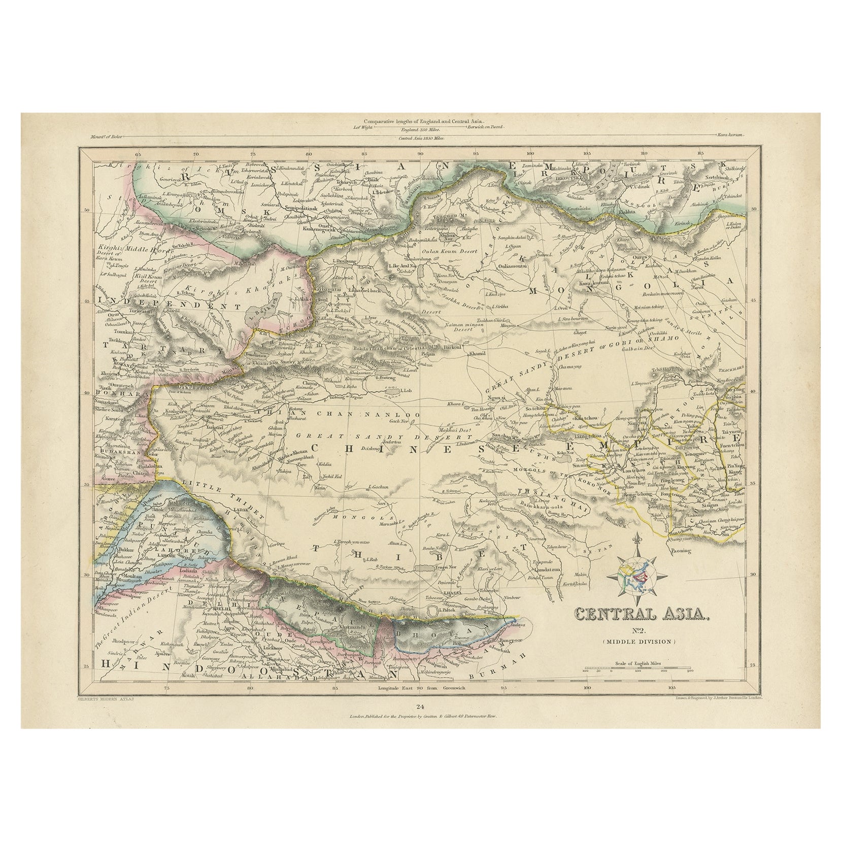
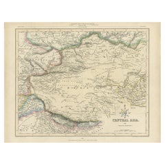
- Antique Map of Central Asia, Finely Engraved, 1841Located in Langweer, NLAntique map titled 'Central Asia, Middle Division'. A finely engraved and attractive mid 19th Century map of Central Asia which was drawn and engraved by Joshua Archer and published ...Category
Antique 19th Century Maps
MaterialsPaper
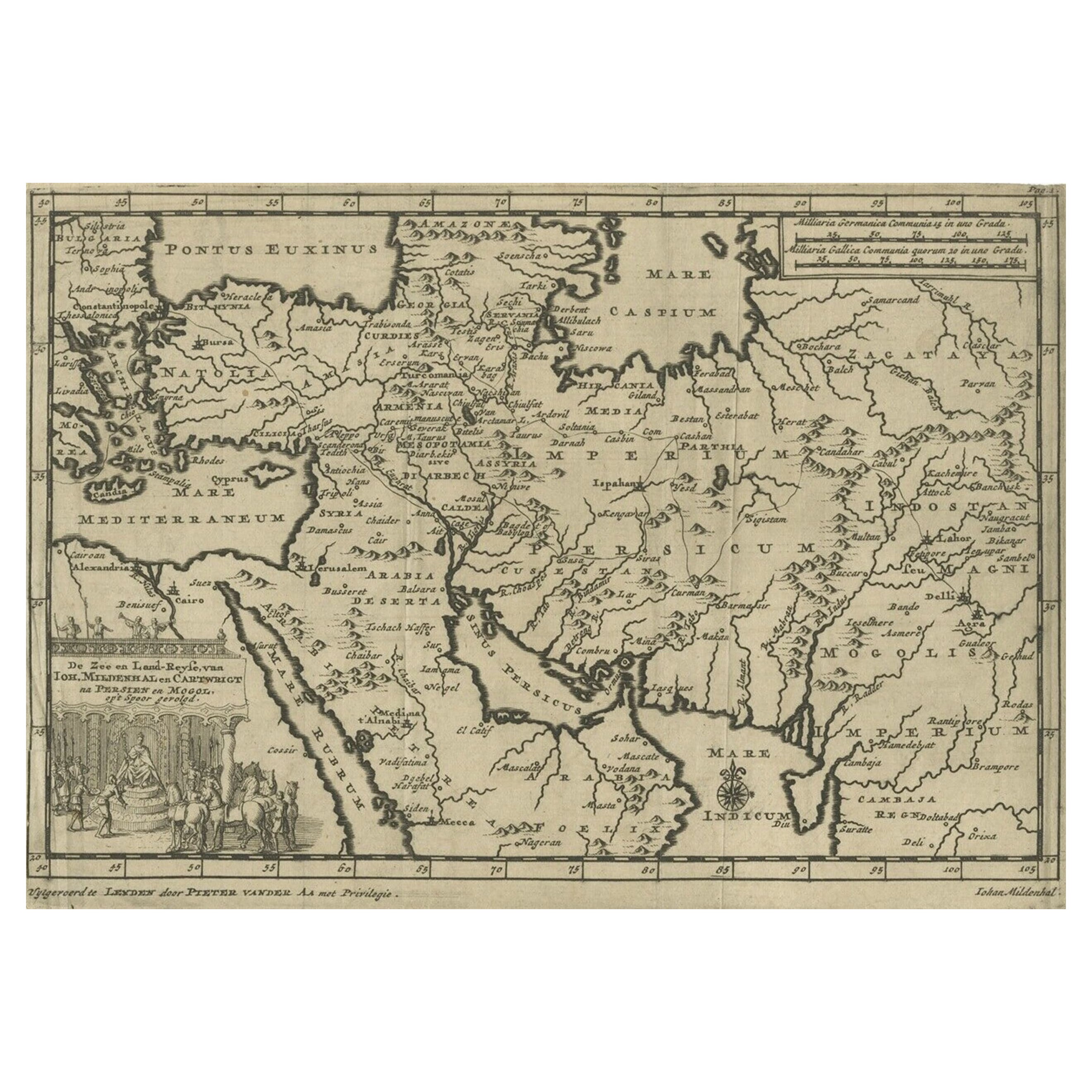
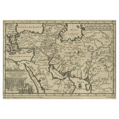
- Old Engraved Map of the Middle East, Arabia and Part of Greece 'Cyprus', 1706Located in Langweer, NLTitle: Antique map titled 'De Zee en Land-Reyse, van Ioh. Mildenhal en Cartwrigt na Persien en Mogol, opt spoor gevolgd'. Old map of the Middle East, also depicting part of Greece ...Category
Antique Early 1700s Maps
MaterialsPaper
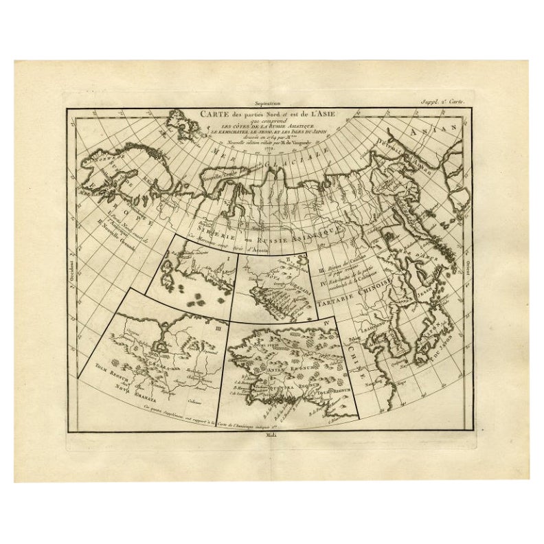
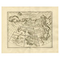
- Antique Map of North and East Asia, 1751Located in Langweer, NLMap 2: 'Carte des parties nord et est de L'Asie'. (Map of the Northern parts and East Asia.) Five maps on one sheet, showing California, Alaska and Siberia, Korea and Japan. South to...Category
Antique 18th Century Maps
MaterialsPaper
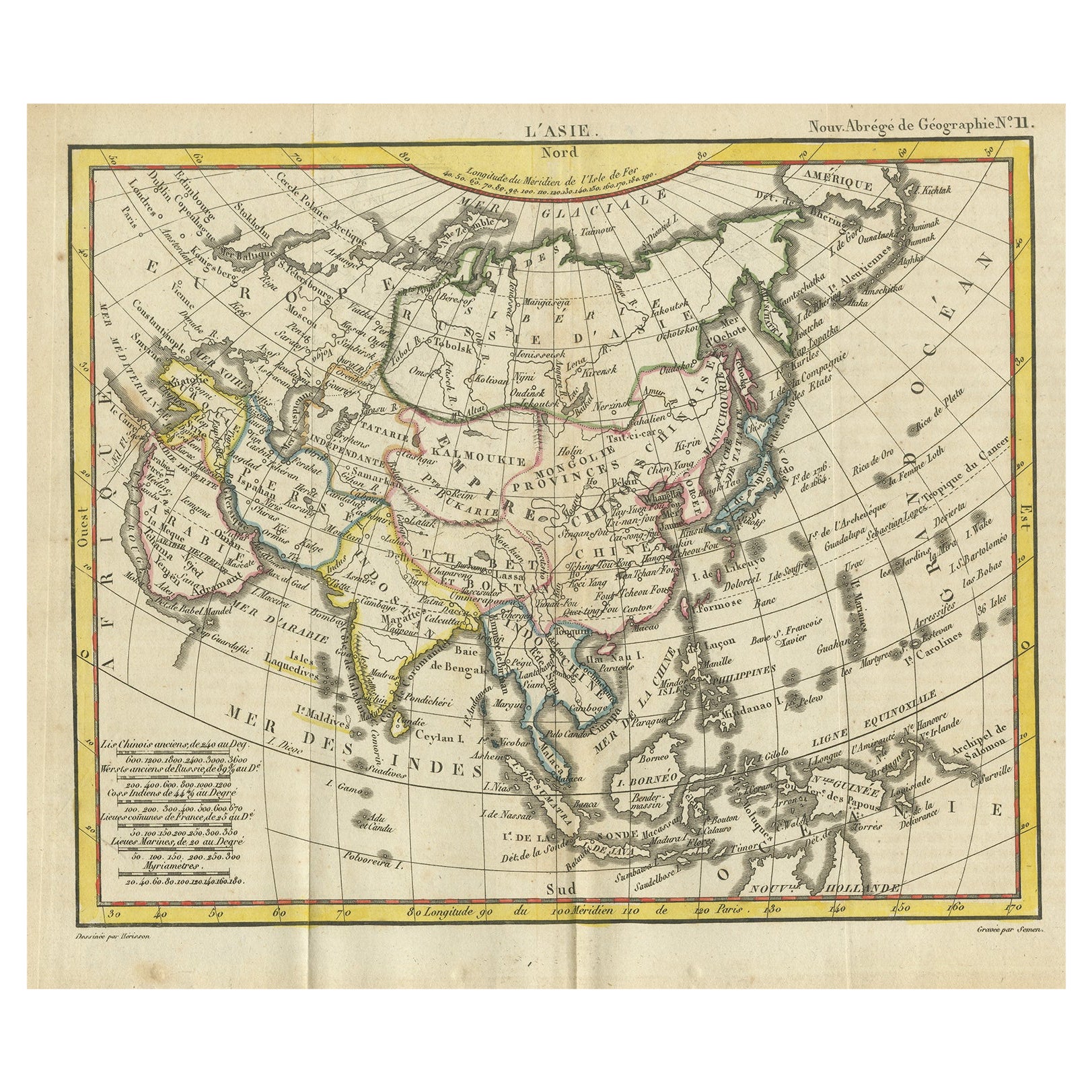
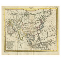
- Antique Map of Asia from the Middle East to the Coast of Alaska, 1816Located in Langweer, NLAntique map titled ‘L’Asie‘. This is an original antique map of Asia, by Hérisson, taken from atlas ""Nouv. Abrége de Géographie"". An engraved map with coloring of Asia from the Mid...Category
Antique 19th Century Maps
MaterialsPaper
- Rare Antique Map of the Middle East, ca.1690Located in Langweer, NLDescription: Antique print, untitled. Two decorative maps on one sheet of the middle east in biblical times. Source unknown, to be determined. Artists and Engravers: Anonymous...Category
Antique 1690s Prints
MaterialsPaper
- Antique Bible Map of the Middle East by A. Schut, 1743Located in Langweer, NLAntique map titled 'De Gelegentheyt van 't Paradys en 't Landt Canaan'. Dutch Bible map covering the region between the Mediterranean and the Persian Gulf, ...Category
Antique Mid-18th Century Maps
MaterialsPaper


You May Also Like
- Original Antique Map of South East Asia, Arrowsmith, 1820Located in St Annes, LancashireGreat map of South East Asia Drawn under the direction of Arrowsmith Copper-plate engraving Published by Longman, Hurst, Rees, Orme and Brown, 1820 Unframed.Category
Antique 1820s English Maps
MaterialsPaper
- Original Antique Map of South East Asia by Becker, circa 1840Located in St Annes, LancashireGreat map of South East Asia Steel engraving with original color outline Engraved by Becker Published by Virtue, circa 1840. Unframed.Category
Antique 1840s English Other Maps
MaterialsPaper
- Original Antique Map of South East Asia by Thomas Clerk, 1817Located in St Annes, LancashireGreat map of South East Asia Copper-plate engraving Drawn and engraved by Thomas Clerk, Edinburgh. Published by Mackenzie And Dent, 1817 Unframed.Category
Antique 1810s English Maps
MaterialsPaper
- Original Antique Map of Asia. C.1780Located in St Annes, LancashireGreat map of Asia Copper-plate engraving Published C.1780 Two small worm holes to right side of map Unframed.Category
Antique Early 1800s English Georgian Maps
MaterialsPaper

- Original Antique Map of Sweden, Engraved by Barlow, 1806Located in St Annes, LancashireGreat map of Sweden Copper-plate engraving by Barlow Published by Brightly & Kinnersly, Bungay, Suffolk. 1806 Unframed.Category
Antique Early 1800s English Maps
MaterialsPaper
- Original Antique Map of The Netherlands, Engraved by Barlow, Dated 1807Located in St Annes, LancashireGreat map of Netherlands Copper-plate engraving by Barlow Published by Brightly & Kinnersly, Bungay, Suffolk. Dated 1807 Unframed.Category
Antique Early 1800s English Maps
MaterialsPaper


Recently Viewed
View AllMore Ways To Browse
Engraved L
Middle East Furniture
Map Light
Twenty Seven
Middle East Antiques
Middle Eastern Antiques
Premier Used Office Furniture
Premier Antiques
Seven Fold
Hemispheres Map
Hemisphere Antiques
Mortier Antique
Antique Hemisphere Maps
Middle East Map
Antique Map Middle East
Middle East Antique Map
Middle East Maps
Map Of Middle East