Items Similar to The Dardanelles in the Age of Sail: A Panoramic Etching, Ca.1765
Want more images or videos?
Request additional images or videos from the seller
1 of 8
The Dardanelles in the Age of Sail: A Panoramic Etching, Ca.1765
$1,145.24
$1,431.5620% Off
£846.59
£1,058.2320% Off
€960
€1,20020% Off
CA$1,588.51
CA$1,985.6420% Off
A$1,731.83
A$2,164.7820% Off
CHF 915.06
CHF 1,143.8320% Off
MX$21,297.40
MX$26,621.7520% Off
NOK 11,378.08
NOK 14,222.6120% Off
SEK 10,710.96
SEK 13,388.7020% Off
DKK 7,309.91
DKK 9,137.3820% Off
About the Item
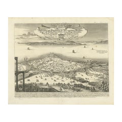
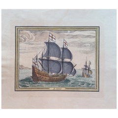
This rare and exquisite view depicts the strategic Dardanelles strait, the narrow passage between the Aegean and the Sea of Marmara with the distant cityscape of Istanbul. Part of the series "Med. Fol. N. 62" as indicated in the bottom left and marked with the number 252 in the top right corner.
The piece showcases the European side with the Kilitbahir Fortress on the left, and the Asian side with the Çimenlik Fortress on the right. Dominating the distant background is the city of Constantinople, situated along the shores of the Sea of Marmara. The etching is animated with the activity of various sailing ships and boats, illustrating the vibrancy of this crucial maritime route.
Published by Georg Balthasar Probst in Augsburg, Germany, and dating from between 1742 and 1801, this colored etching is a testament to the artistic and cartographic skills of the period, as well as to the significance of the Dardanelles in international trade and military history. The work comes with the privilege granted by Joseph II, the German emperor, enhancing its historical value. The watermark inscription suggests a link to Turkish possessions, likely referring to the Ottoman control of the region. This etching is a splendid representation of an era where maritime prowess was pivotal, and it holds both artistic and historical significance.
Technical details:
View of the sea strait the Dardanelles. Prospect of the Sea Narrow at the Dardanelles (title on object). Dardanelles (series title)
Object type: print, optical print
Inscriptions / Brands: watermark inscription, recto bottom left, handwritten: ‘entrance of the / Hellespont or Black Sea / Turkish possession’
Publisher: Georg Balthasar Probst (mentioned on object), printmaker: anonymous, grantor of privilege: Joseph II (German emperor) (mentioned on object)
Place of manufacture: publisher: Augsburg, printmaker: Germany
Date: 1742 - 1801
Physical characteristics: colored etching
Material: paper, watercolor
Technique: etching / brush
The series “Dardanelles”, with the number 62, contains two prints with the numbers 252 and 253, of which this is number 252.
- Dimensions:Height: 12.6 in (32 cm)Width: 17.6 in (44.7 cm)Depth: 0 in (0.02 mm)
- Materials and Techniques:Paper,Engraved
- Period:1760-1769
- Date of Manufacture:circa 1765
- Condition:Good condition. Some browning and soiling, mainly around the edges. Offset in the top (sky), otherwise nice impression with strong colors. Study the image carefully.
- Seller Location:Langweer, NL
- Reference Number:Seller: BG-13643-31stDibs: LU3054338040442
About the Seller
5.0
Recognized Seller
These prestigious sellers are industry leaders and represent the highest echelon for item quality and design.
Platinum Seller
Premium sellers with a 4.7+ rating and 24-hour response times
Established in 2009
1stDibs seller since 2017
2,620 sales on 1stDibs
Typical response time: <1 hour
- ShippingRetrieving quote...Shipping from: Langweer, Netherlands
- Return Policy
Authenticity Guarantee
In the unlikely event there’s an issue with an item’s authenticity, contact us within 1 year for a full refund. DetailsMoney-Back Guarantee
If your item is not as described, is damaged in transit, or does not arrive, contact us within 7 days for a full refund. Details24-Hour Cancellation
You have a 24-hour grace period in which to reconsider your purchase, with no questions asked.Vetted Professional Sellers
Our world-class sellers must adhere to strict standards for service and quality, maintaining the integrity of our listings.Price-Match Guarantee
If you find that a seller listed the same item for a lower price elsewhere, we’ll match it.Trusted Global Delivery
Our best-in-class carrier network provides specialized shipping options worldwide, including custom delivery.More From This Seller
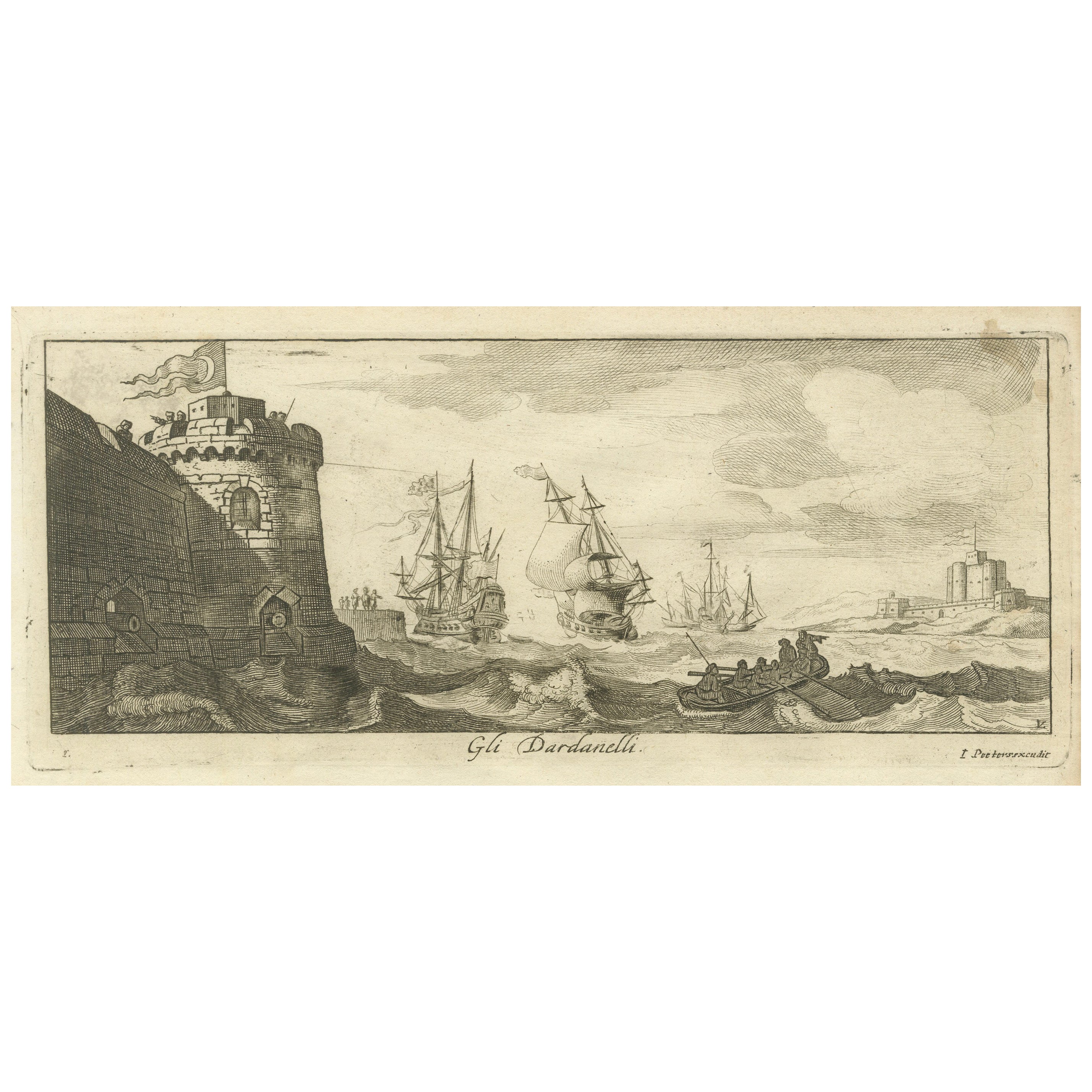
View AllEngraved View of the Dardanelles with Fortifications and Ships, ca. 1680
Located in Langweer, NL
Title: View of the Dardanelles with Fortifications and Ships, ca. 1680
Description: This copperplate engraving offers a detailed view of the Dardanelles Strait, emphasizing its s...
Category
Antique 1680s Prints
Materials
Paper

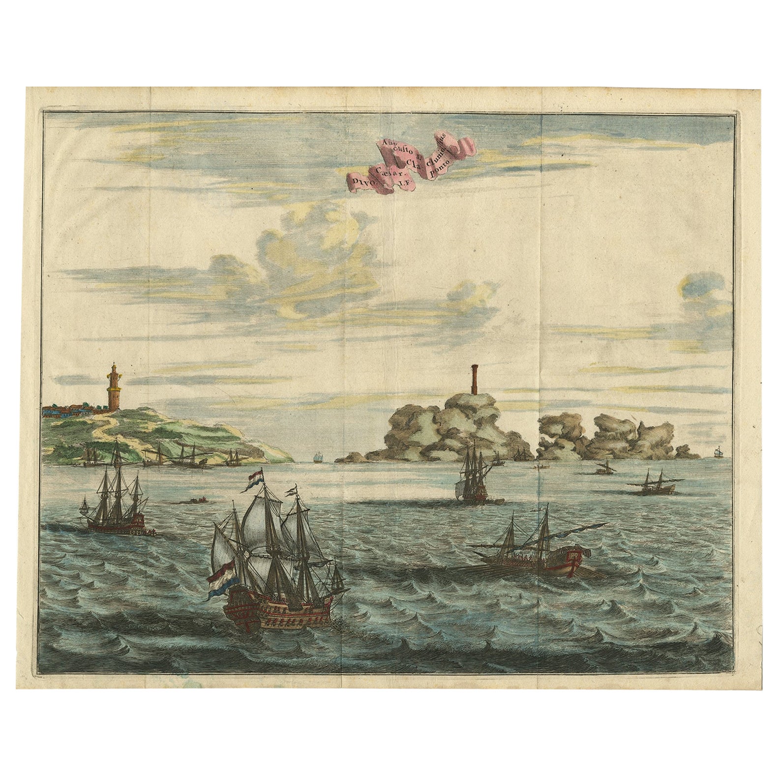
Antique Print of the Dardanelles, Turkey, 1677
Located in Langweer, NL
Antique print titled 'Divo Caesar Augusto L. Clunidius I. F. Cla: ponto'. Original antique print showing a view of the Dardanelles, Turkey, with ships. This print originates from 'Na...
Category
Antique 17th Century Prints
Materials
Paper
$515 Sale Price
20% Off
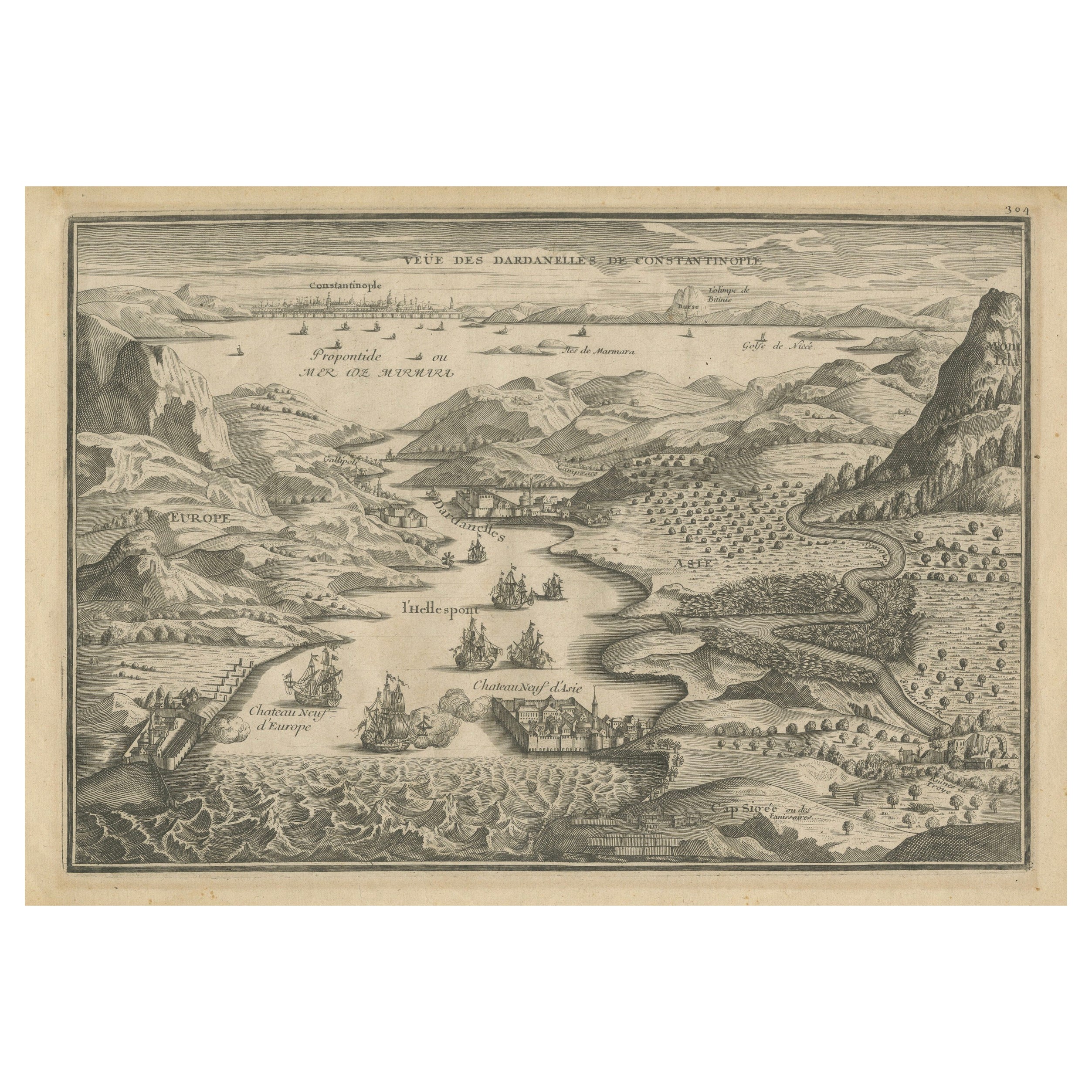
Dardanelles Strait, with a Perspective of the City of Constantinople, 1693
Located in Langweer, NL
Title: "Veue des Dardanelles de Constantinople, 1693"
Description: This historical copper engraving, crafted by Nicholas de Fer between 1646 and 1720 in Paris, is a remarkable depic...
Category
Antique 1690s Prints
Materials
Paper

$324 Sale Price
20% Off
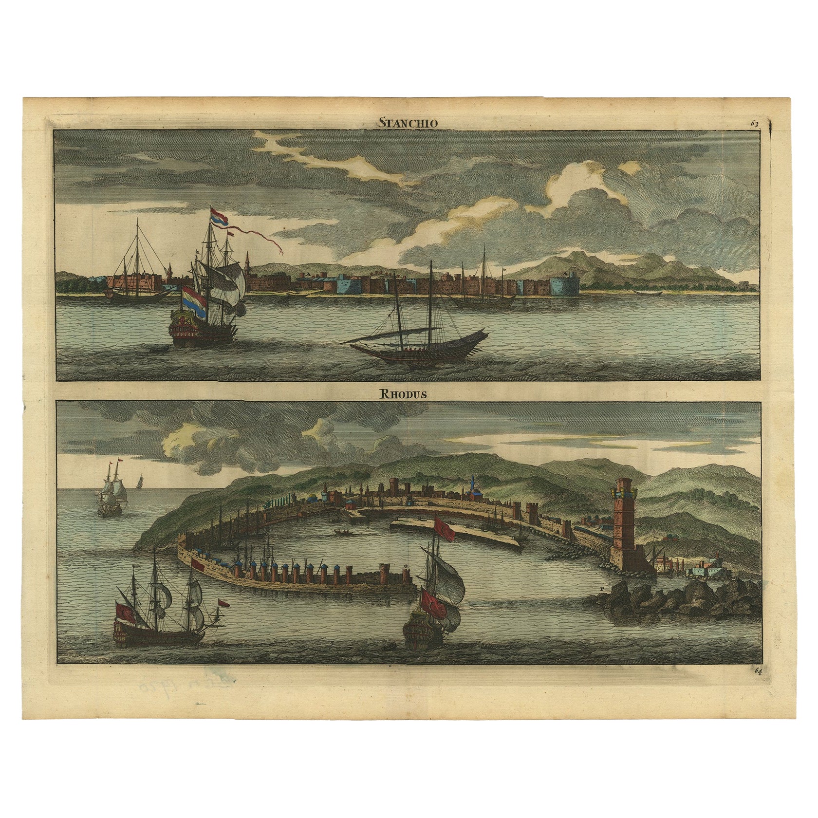
Rare & Old Panoramic Views of Stanchio, Greece and the Island of Rhodes, 1698
Located in Langweer, NL
Antique print titled Stanchio Rhodus.
Original antique print showing panoramic views of Stanchio, Greece and the Island of Rhodes, both with ships.
First edition in French, firs...
Category
Antique 1690s Dutch Prints
Materials
Paper
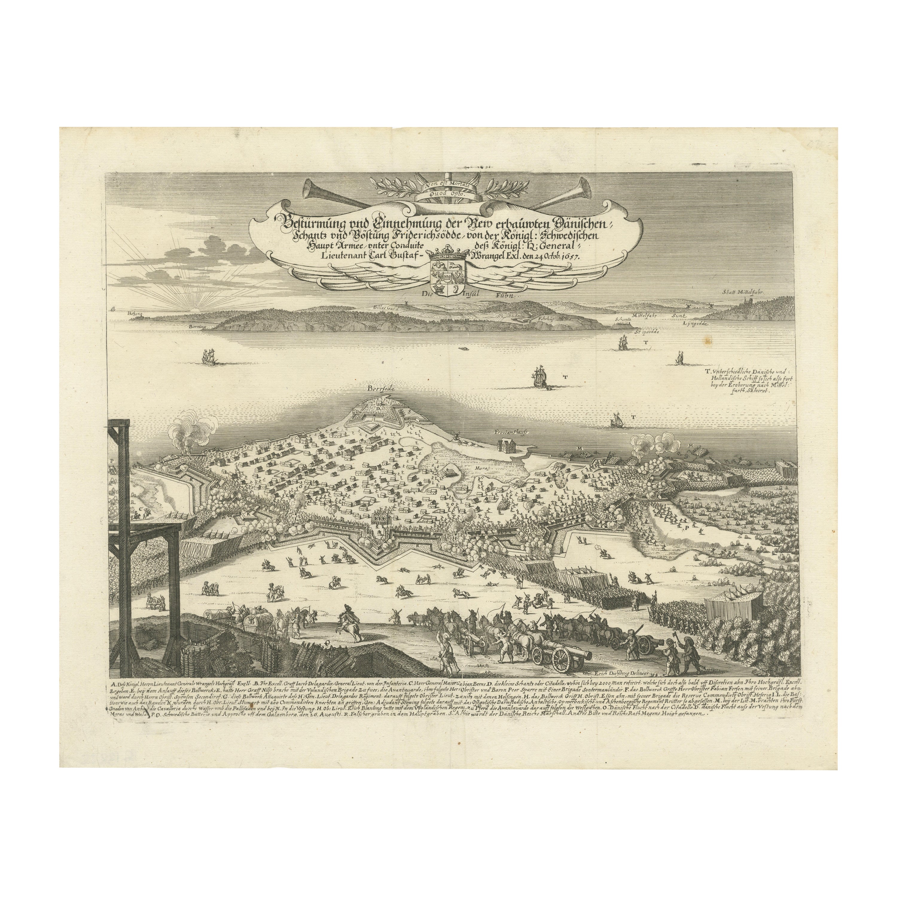
Prince Henry's Naval and Land Battle during the Seven Years' War Engraved, 1667
Located in Langweer, NL
The engraving depicts the assault and capture of the Danish fortress Friderichsodde (now known as Fredericia) located on the island of Fyn. The scene, captured on October 24, 1657, vividly illustrates the Swedish main army's takeover under the command of General Carl Gustaf Wrangel. This historical event is meticulously documented in the artwork, which showcases not only the military action but also the strategic landscape and fortifications characteristic of the time.
Erik Jönsson Graf von Dahlberg, the artist behind this work, was a prominent Swedish field marshal, architect, and fortress builder. Born in 1625 and passing in 1703, Dahlberg's contributions to military and architectural fields were significant. He was renowned for his detailed and artistically valuable drawings which served as the basis for large-scale copperplate engravings. These engravings are of substantial topographical and architectural historical importance as they provide a detailed visual account of Swedish territories during the era.
In 1661, Dahlberg began work on his magnum opus—a comprehensive geographical and historical depiction of Swedish territories, which received royal privileges. His journey in 1667-1668 to Paris for the engraving of the initial plates reflects the international scope and ambition of his project. However, the work was intermittently paused when Dahlberg was tasked in 1674 with overseeing all Swedish fortress constructions, a role that significantly impacted his career and works. The project resumed and was published in 1684, highlighting a significant period of Swedish history and military achievements under his visual documentation.
MORE ABOUT THE BATTLE:
The image is an intricate engraving depicting a battle scene. Based on the details and the text in the cartouche, the scene illustrates a significant historical battle involving Prussian forces. The presence of multiple ships and extensive fortifications suggests a combined land and naval engagement.
Key Features in the Engraving:
1. Land Battle: The forefront of the image shows numerous troops, artillery pieces, and cavalry in action, depicting the intensity and scale of the land combat.
2. Naval Elements: Ships in the background indicate that this battle had a naval component, which would have been crucial for controlling trade routes or strategic waterways.
3. Fortifications: Extensive fortifications, including bastions and protective walls, suggest a well-defended location, possibly a city or a significant stronghold.
Historical Context:
From the text, it appears the battle involves "Prinz Heinrich," referring to Prince Henry of Prussia, who was an influential military leader during the reign of his brother, Frederick the Great. Under Frederick’s rule, Prussia engaged in several key conflicts, including the Seven Years' War (1756-1763), which saw major battles across Europe and involved complex alliances.
Given the level of detail and the era suggested by the style of ships and fortifications, the battle was of the significant engagements during the Seven Years' War, where Prince Henry played a critical role. His campaigns often involved maneuvering to protect Prussia from multiple fronts, including naval engagements in the Baltic.
Interpretation:
This engraving serves not only as a historical document but also as a piece of propaganda, likely glorifying the prowess and strategic capabilities of the Prussian military...
Category
Antique 1670s Prints
Materials
Paper
$439 Sale Price
20% Off
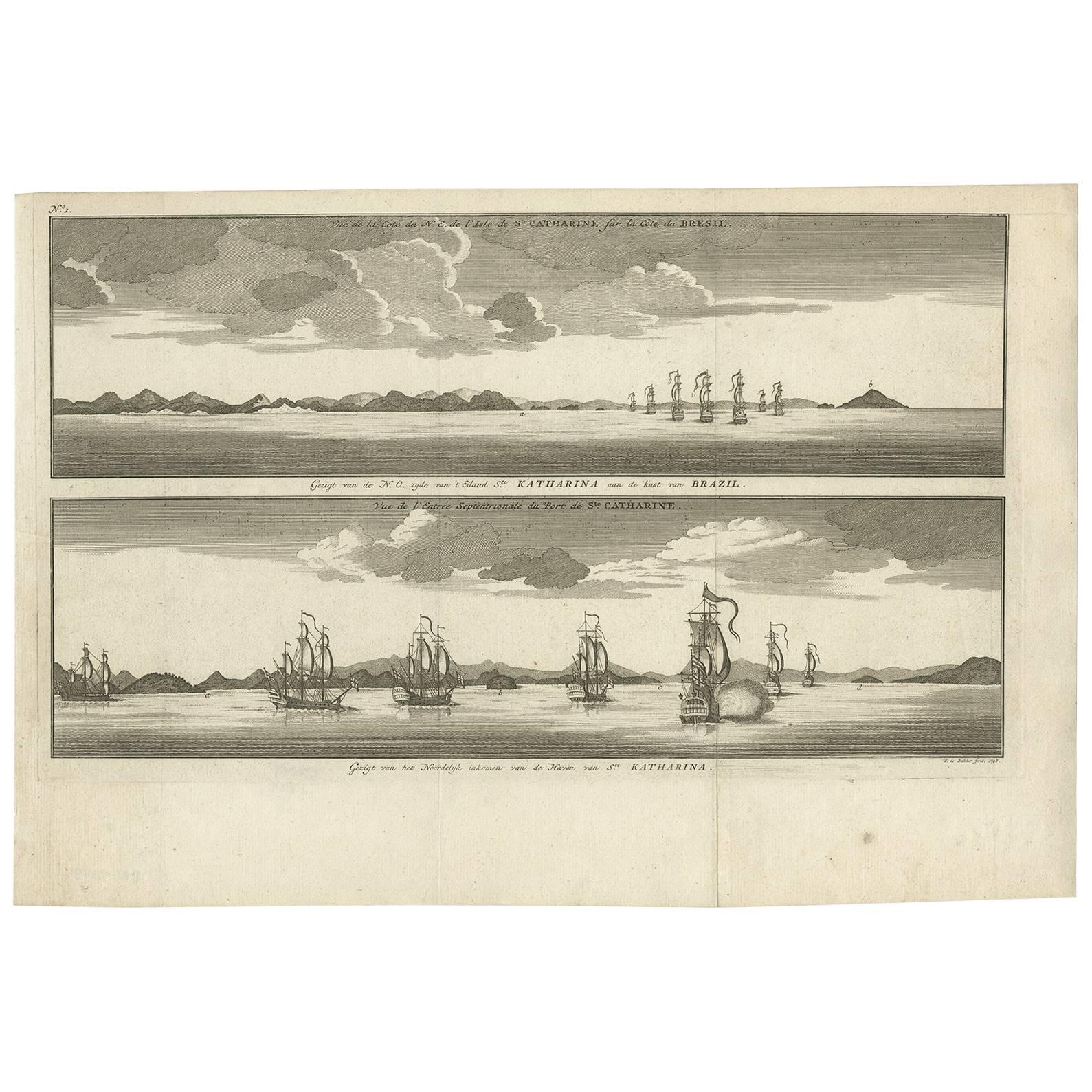
Antique Print with views of Santa Catarina Island by Anson (c.1760)
Located in Langweer, NL
Plate no.1: 'Vue de la cote de N.E. de l'Isle de Ste. Catharine sur la cote du Bresil.' - 'Vue de l'entree septentrionale du port de Ste. Catharine.' (View of the coast of the N.E. o...
Category
Antique Mid-18th Century Prints
Materials
Paper
$200 Sale Price
20% Off
You May Also Like
Antique Voc Print Holland Malaysia Old Map Melaka History, 1663
Located in Amsterdam, Noord Holland
From my own collection I offer this impressive Antique print of the city of Malakka
A very interesting piece for collectors . It is an museum piece from the Dutch Institute of Orien...
Category
Antique 17th Century European Paintings
Materials
Paper

$293 Sale Price
20% Off
Early 18th Century Engraving of the Northern Whale Fishery, circa 1720
Located in Nantucket, MA
Very early 18th century Dutch woodblock engraving of the Northern Whale Fishery, circa 1720, a hand colored engraving illustrating the Dutch whaling flee...
Category
Antique 1720s Dutch Baroque Prints
Materials
Paper
Lithograph View on Nieuw Amsterdam J . Vingboons 1660s
Located in Den Haag, NL
Afther a gouache by J Vingboons 1660s Beautiful Lithograph from 1910/20
Nieuw Amsterdam ofte nue nieuw Lorx opt Teyland Man .
Very nice fresh colors . Comes with a old label on the...
Category
Antique 1650s Dutch American Colonial Prints
Materials
Paper
18th Century Color Engraving Print by Pieter F.H. Bruegel, Le Depart
Located in Miami, FL
Original 18th century color engraving print by renowned artist Pe. F.H. Bruegel.
A fine crisp impression of great rarity; it is particularly unusual to find color engravings of th...
Category
Antique 18th Century French Prints
Materials
Paper
Engraving Print from the Panckoucke Encyclopédie Nautical Subject 1782-1832
Located in Milan, IT
Print by engraving on copper plate from the Panckoucke Encyclopédie méthodique, end of the 18th century,volume Marine Planches (more than 1,500 figures dealing with all subjects on the marina: planes, construction, carpentry, tree trunks, armaments of maneuvers, ropes, sails, artillery, ship maneuvers and combat tactics). This is the plate no. n. 24, pag. 69 fig. 341 ; with frame cm 38.3 x 31.5. Ship ropes are depicted. The Print has the "Benard direxit...
Category
Antique 1790s French Nautical Objects
Materials
Paper
A View of Cape Rouge, Quebec, Canada, Mazell after Capt. Hervey Smyth, c.1760s
Located in Savannah, GA
A View of Cape Rouge, or Carouge, on the Saint Lawrence River, north of Quebec.
Engraving by Peter Mazell after a drawing by Captian Hervey Smyth, published c.1760's, London.
T...
Category
Antique 1760s Canadian British Colonial Prints
Materials
Paper
More Ways To Browse
Virgin Mary Italy
Walter Bosse Elephant
Water Buffalo Horns
Wavy Drawers
Wedgwood Jasperware Plaque
Wedgwood Used
Welsh Wales Art
White Cockatoo
White Elephant Sculpture
White Lacquer Asian
White Marble Top Commode
White Queen Anne
White Tara
Wide Chest Drawers
Wood And Painted Elephant
Wood Caryatids
Wood Skeleton Skeleton
Wooden Monkeys