Items Similar to Hand-colored lithograph map and view of the Chincha Islands, Peru – 1865

Video Loading
Want more images or videos?
Request additional images or videos from the seller
1 of 11
Hand-colored lithograph map and view of the Chincha Islands, Peru – 1865
$640.22
£479.14
€540
CA$883.24
A$982.20
CHF 515.87
MX$12,008.40
NOK 6,428.28
SEK 6,060.13
DKK 4,110.75
About the Item
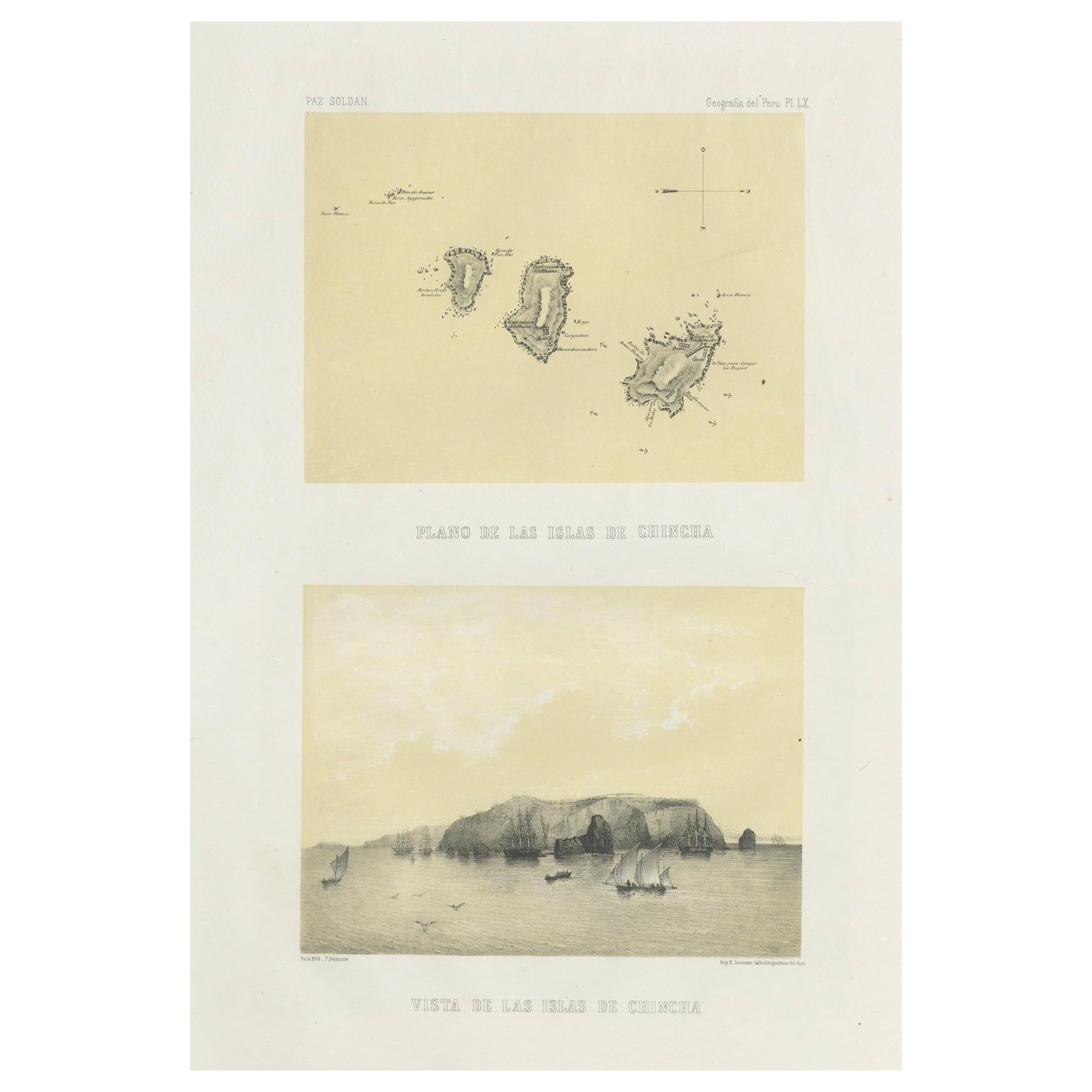
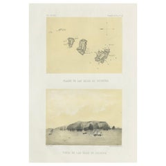
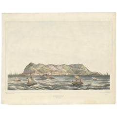
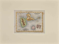
Hand-colored lithograph map and view of the Chincha Islands, Peru – 1865
This original hand-colored lithograph sheet presents both a map (Plano de las Islas de Chincha) and a panoramic coastal view (Vista de las Islas de Chincha), published in 1865 in Mariano Felipe Paz Soldán’s Atlas Geográfico del Perú. Printed in Paris by Lemercier, this atlas was the first national atlas of Peru and remains one of the most important illustrated works on the country from the 19th century.
The upper section shows a delicately hand-colored map of the three Chincha Islands, highlighting their rugged coastlines and navigational features. The lower section presents a lively coastal scene: ships and smaller sailing vessels move across calm waters, with the rocky mass of the islands rising dramatically in the background. The application of color enhances the naturalistic qualities of the sea, sky, and rock formations, lending depth and visual vibrancy to the composition.
The Chincha Islands were of immense historical importance in the mid-19th century due to their vast guano deposits, a resource that transformed Peru into a major global exporter of fertilizer. Revenue from guano exports funded infrastructure, modernization, and public works across Peru, making the Chincha Islands central to both economic prosperity and international diplomacy.
This hand-colored plate is especially desirable, as most examples of Paz Soldán’s atlas were issued in plain tint stone. Collectors of Latin American history, economic history, and maritime art will appreciate this print both for its rarity and its documentary value.
Condition report:
Good condition. Original hand-coloring well preserved and fresh. Vertical flattened crease visible. Light foxing in the margins, typical for 19th-century paper, not affecting the images. Wide margins intact with plate mark visible.
Framing tips:
This double composition should be framed vertically, allowing both the map and the coastal view to be fully appreciated. A cream or off-white mat will bring out the subtle hand-coloring, while a dark wood or black frame will add contrast. A thin inner mat in muted sea green or ochre could complement the natural tones of the lithograph.
Technique: Hand-colored lithograph with tint stone
Maker: Mariano Felipe Paz Soldán, Paris, 1865
- Dimensions:Height: 20.04 in (50.9 cm)Width: 13.39 in (34 cm)Depth: 0.01 in (0.2 mm)
- Materials and Techniques:
- Place of Origin:
- Period:
- Date of Manufacture:circa 1865
- Condition:Good condition. Original hand-coloring well preserved and fresh. Vertical flattened crease visible. Light foxing in the margins, typical for 19th-century paper, not affecting the images. Wide margins intact with plate mark visible.
- Seller Location:Langweer, NL
- Reference Number:Seller: BG-14032-201stDibs: LU3054346484772
About the Seller
5.0
Recognized Seller
These prestigious sellers are industry leaders and represent the highest echelon for item quality and design.
Platinum Seller
Premium sellers with a 4.7+ rating and 24-hour response times
Established in 2009
1stDibs seller since 2017
2,607 sales on 1stDibs
Typical response time: <1 hour
- ShippingRetrieving quote...Shipping from: Langweer, Netherlands
- Return Policy
Authenticity Guarantee
In the unlikely event there’s an issue with an item’s authenticity, contact us within 1 year for a full refund. DetailsMoney-Back Guarantee
If your item is not as described, is damaged in transit, or does not arrive, contact us within 7 days for a full refund. Details24-Hour Cancellation
You have a 24-hour grace period in which to reconsider your purchase, with no questions asked.Vetted Professional Sellers
Our world-class sellers must adhere to strict standards for service and quality, maintaining the integrity of our listings.Price-Match Guarantee
If you find that a seller listed the same item for a lower price elsewhere, we’ll match it.Trusted Global Delivery
Our best-in-class carrier network provides specialized shipping options worldwide, including custom delivery.More From This Seller
View AllChincha Islands Antique Lithograph 1865 – Map & Coastal Scene, Peru
Located in Langweer, NL
Antique lithograph map and view of the Chincha Islands, Peru – 1865
This lithograph sheet presents both a map (Plano de las Islas de Chincha) and a coastal view (Vista de las Islas ...
Category
Antique 1860s French Prints
Materials
Paper
Antique Engraved Map with Original Hand Colour of French Guiana, 1876
Located in Langweer, NL
The 1876 map of French Guiana from the "Grand Atlas Départemental de la France de L'Algérie et des colonies" by H. Fisquet, published by A. Le Vasseur in Paris, is a significant piec...
Category
Antique Late 19th Century Maps
Materials
Paper
$265 Sale Price
20% Off
Antique Map of Taluti Bay by Stemler, C.1875
Located in Langweer, NL
Antique map titled 'Kaart der Teloeti Baai op Ceram.' This scarce map shows the Taluti Bay on the Moluccan island of Ceram. Originates from 'Tijdschrift Aardrijkskundig Genootschap',...
Category
Antique 19th Century Maps
Materials
Paper

$116 Sale Price
20% Off
Antique Map of Eastern Polynesia, 1849
Located in Langweer, NL
Antique map titled 'Ost-Polynesien'. Interesting variant issue, with large detailed insets top right of Hawaii volcanos near Kilauea. Insets lower right of Honolulu harbour, island o...
Category
Antique Mid-19th Century Maps
Materials
Paper

$165 Sale Price
30% Off
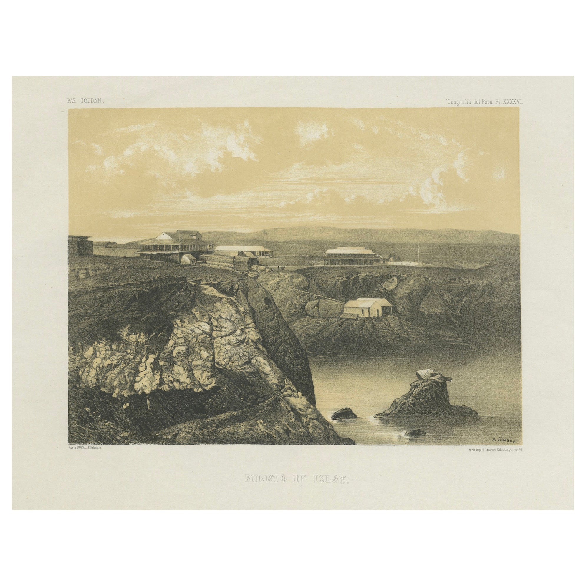
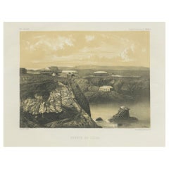
Puerto de Islay Peru – Antique Coastal Port Lithograph c.1865
Located in Langweer, NL
Antique lithograph view of Puerto de Islay, Peru – 1865
This original lithograph presents a striking 19th-century view of Puerto de Islay, the coastal settlement in southern Peru th...
Category
Antique 1860s French Prints
Materials
Paper
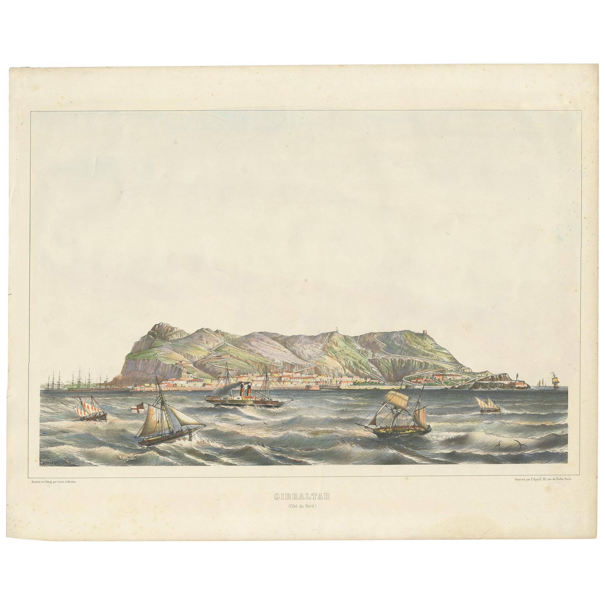
Antique Print of the North Coast of Gibraltar by F. Appel 'c.1890'
Located in Langweer, NL
Antique print titled 'Gibraltar (Côte du Nord)'. View of Gibraltar. Published by F. Appel after a painting by Louis Lebreton. Published circa 1890.
Category
Antique Late 19th Century Prints
Materials
Paper
$474 Sale Price
20% Off
You May Also Like
Large Original Antique Map of The Canary Islands. 1894
Located in St Annes, Lancashire
Superb Antique map of The Canary Islands
Published Edward Stanford, Charing Cross, London 1894
Original colour
Good condition
Unframed.
Free shipping
Category
Antique 1890s English Maps
Materials
Paper

Map of Guadalupe - Lithograph - 19th Century
Located in Roma, IT
Map of Guadalupe is a Lithograph realized by Various artists in the 19th Century, part of the suite "France Pittoresque".
Good conditions.
Category
Late 19th Century Modern Figurative Prints
Materials
Lithograph
A Hand Colored 18th Century Framed Map of South America by Thomas Jefferys
Located in Alamo, CA
This detailed hand colored map of South America by Thomas Jefferys was published in London in 1750. The map shows countries, early colonial possessions, towns, rivers, mountains, and...
Category
Mid-18th Century Other Art Style Landscape Prints
Materials
Engraving

Hand Colored Framed Map Print of North Africa
By Abraham Ortelius
Located in Barcelona, ES
Original antique map of North Africa
Antique framed map print titled 'Barbariae et Biledulgerid Nova Descriptio'.
Artist: Abraham Ortelius (1527 -1598)
Published by A. Ortelius, ci...
Category
20th Century European Spanish Colonial Prints
Materials
Giltwood, Paper

1865 Chart of the Islands of Madeira
Located in Norwell, MA
Rare James Imray chart from 1865 titled "Chart of the Islands of Madeira, Porto Santo and Dezerea" drawn from the survey made by Captain Ate Vidal Royal Navy, London. Published by Ja...
Category
Antique 1860s European Maps
Materials
Paper

View of the Island of San Mauro - Lithograph by Giuseppe Ruo- 1880s
Located in Roma, IT
Lithograph hand watercolored, realized by Giuseppe Ruo in 1880s.
Good condition.
Category
1880s Modern Landscape Prints
Materials
Lithograph
$160 Sale Price
25% Off