Items Similar to Old Horizontal Map of England


Want more images or videos?
Request additional images or videos from the seller
1 of 10
Old Horizontal Map of England
$718.02
£533.37
€600
CA$990.56
A$1,088.90
CHF 572.28
MX$13,223.20
NOK 7,138.99
SEK 6,763.69
DKK 4,567.51
About the Item
ST/520 - Old rare Italian map of England, dated 1826-1827 - by Girolamo Tasso, editor in Venise, for the atlas of M.r Le-Sage.
- Creator:Tasso (Author)
- Dimensions:Height: 15.75 in (40 cm)Width: 21.26 in (54 cm)Depth: 0.04 in (1 mm)
- Style:Other (In the Style Of)
- Materials and Techniques:Paper,Other
- Place of Origin:
- Period:
- Date of Manufacture:1827
- Condition:
- Seller Location:Alessandria, IT
- Reference Number:1stDibs: LU1379223166822
About the Seller
4.8
Vetted Professional Seller
Every seller passes strict standards for authenticity and reliability
Established in 1984
1stDibs seller since 2015
373 sales on 1stDibs
Typical response time: 12 hours
- ShippingRetrieving quote...Shipping from: Alessandria, Italy
- Return Policy
Authenticity Guarantee
In the unlikely event there’s an issue with an item’s authenticity, contact us within 1 year for a full refund. DetailsMoney-Back Guarantee
If your item is not as described, is damaged in transit, or does not arrive, contact us within 7 days for a full refund. Details24-Hour Cancellation
You have a 24-hour grace period in which to reconsider your purchase, with no questions asked.Vetted Professional Sellers
Our world-class sellers must adhere to strict standards for service and quality, maintaining the integrity of our listings.Price-Match Guarantee
If you find that a seller listed the same item for a lower price elsewhere, we’ll match it.Trusted Global Delivery
Our best-in-class carrier network provides specialized shipping options worldwide, including custom delivery.More From This Seller
View AllMap "Estuary- Mouth of the Thames"
Located in Alessandria, Piemonte
ST/426 - Antique French Map of the estuary of the Thames, map dated 1769 -
"Mape of the entrance of the Thames. Designed by filing of Navy cards fo...
Category
Antique Mid-18th Century French Other Prints
Materials
Paper

Ancient National Atlas of France with Marengo
Located in Alessandria, Piemonte
Ancient National Atlas of France with the department of Marengo: a rare French etching dated 1806.
ST/178.
Category
Antique Early 19th Century French Other Prints
Materials
Paper

Geographical Map of Italy
Located in Alessandria, Piemonte
BOLIS Publishing House - Bergamo.
A beautiful large map of Italy, on paper but suitably reinforced to preserve it correctly. The maps were usually p...
Category
Mid-20th Century Italian Other Prints
Materials
Paper

Antique Map of Principality of Monaco
By Antonio Vallardi Editore
Located in Alessandria, Piemonte
ST/619 - "Old Geographical Atlas of Italy - Topographic map of ex-Principality of Monaco" -
ediz Vallardi - Milano -
A somewhat special edition ---
Category
Antique Late 19th Century Italian Other Prints
Materials
Paper

Geographical Antique Map of Principality of Monaco
By Bruno Santini
Located in Alessandria, Piemonte
ST/609 - Interesting antique color map of Monaco Principality in French language : "Carte qui contient le Principauté de Piémont, le Monferrat et la comté de...
Category
Antique Late 18th Century Italian Other Maps
Materials
Paper

Frontespice "The Mansions of England in the Olden Time"
By Joseph Nash
Located in Alessandria, Piemonte
ST/218-1 - Antique English print by Joseph Nash (1809-1878), famous British painter, member of the Gothic Revival Group. In 1838 he published the Revival Lithographic Collection "Medieval...
Category
Antique Mid-19th Century English Other Prints
Materials
Paper

You May Also Like
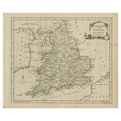
Antique Map of England & Wales by Wyld '1845'
Located in Langweer, NL
Antique map titled 'England & Wales'. Original antique map of England & Wales. This map originates from 'An Atlas of the World, Comprehending Se...
Category
Antique Mid-19th Century Maps
Materials
Paper

$136 Sale Price
24% Off
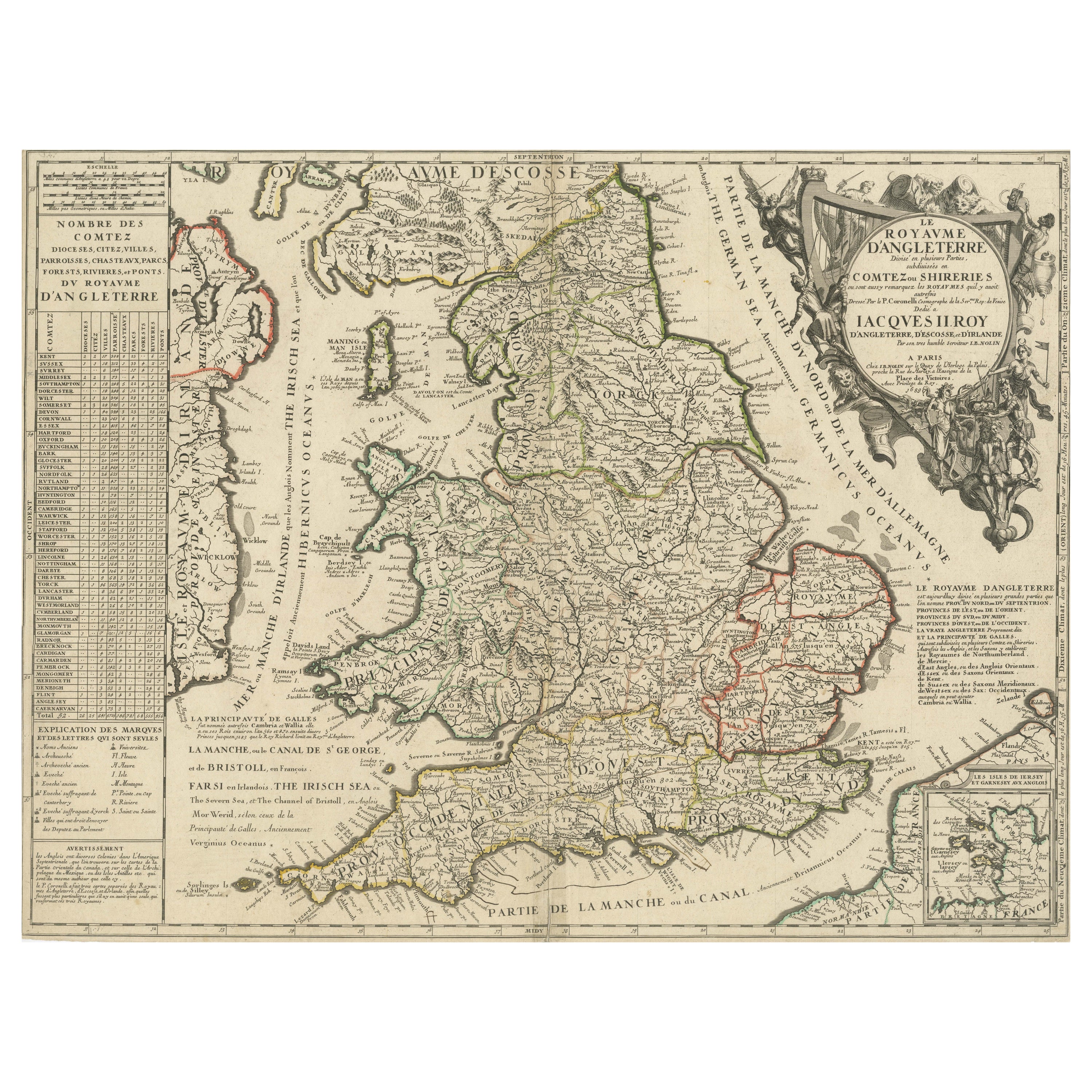
Original Antique Map of England and Wales with Large Cartouche
Located in Langweer, NL
Antique map titled 'Le Royaume d'Angleterre divisé en plusieurs Parties (..)'. Large and rare map of England and Wales by J.B. Nolin after Coronelli. With decorative cartouche, table...
Category
Antique Late 17th Century Maps
Materials
Paper

$423 Sale Price
20% Off
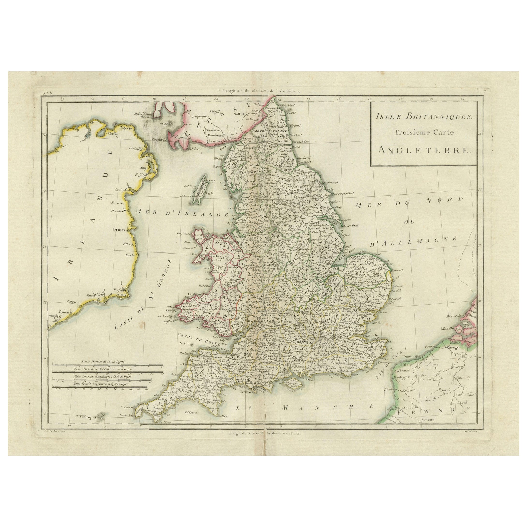
Map of England and Surrounding Regions: Early 19th Century - 1802 Tardieu Atlas
Located in Langweer, NL
Title: Isles Britanniques. Troisieme Carte, Angleterre
Publication Details:
- **Atlas Title:** Nouvel Atlas Universel de Géographie Ancienne et Moderne
- **Purpose:** For the Nouve...
Category
Antique Early 1800s Maps
Materials
Paper
$366 Sale Price
20% Off
Original Antique Map of England and Wales, with Decorative Cartouche
Located in Langweer, NL
Antique map titled 'England and Wales from the best Authorities'. Original antique map of England and Wales, with decorative cartouche. Engraved by T. Conder. Published circa 1790.
Category
Antique Late 18th Century Maps
Materials
Paper
$154 Sale Price
20% Off
Antique Map of England and Wales, with References to the Counties
Located in Langweer, NL
Antique map titled 'England and Wales'. Original antique map of England and Wales, with references to the counties. Source unknown, to be determined. Published circa 1820.
Category
Antique Early 19th Century Maps
Materials
Paper
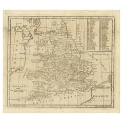
$134 Sale Price
20% Off
Original Antique Map of England with Hand Coloring
Located in Langweer, NL
Antique map titled 'Engand'. Original old map of England. Engraved by W. Milton. Published by John Mc. Gowan, circa 1829.
Category
Antique Mid-19th Century Maps
Materials
Paper
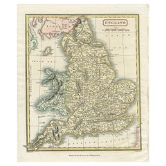
$211 Sale Price
20% Off
More Ways To Browse
Paul Wood Etching
Pierre Bouillon
Prints From The Louvre
Queen Victoria Print
Racehorse Engraving
Tanzania Antique Map
Toulouse Lautrec Signed Lithograph
Turner Flamingo
Vertes Dancing
Vintage Air Race
Vintage Boardwalk
Vintage German Shepherd Prints
Weaver Bird Print
Wharton Esherick Print
18th Century Nautical Engraving
1950 Skira Ceramic Print
Abraham Lincoln Engraving
Acinonyx Jubatus