Items Similar to View of Frankenberg: Braun & Hogenberg's Historic Bird's-Eye Map, 1599


Want more images or videos?
Request additional images or videos from the seller
1 of 5
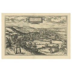
View of Frankenberg: Braun & Hogenberg's Historic Bird's-Eye Map, 1599
$477.19
$596.4820% Off
£352.74
£440.9320% Off
€400
€50020% Off
CA$661.88
CA$827.3520% Off
A$721.59
A$901.9920% Off
CHF 381.28
CHF 476.6020% Off
MX$8,873.92
MX$11,092.4020% Off
NOK 4,740.87
NOK 5,926.0920% Off
SEK 4,462.90
SEK 5,578.6220% Off
DKK 3,045.79
DKK 3,807.2420% Off
About the Item
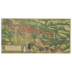
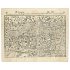
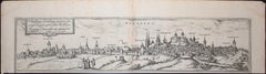
The antique print titled 'Francenbergum, vel ut alij Francoburgum Hassiae Opp', published by Braun & Hogenberg around 1599, is a remarkable historical document offering a bird's-eye view of Frankenberg, a town in the Waldeck-Frankenberg district, Hesse, Germany. This print is part of a rich tradition of city maps and views from the late 16th century.
**Key Characteristics of the Print:**
1. **Bird's-Eye View**: The print provides a detailed aerial perspective of Frankenberg, a popular style in the late Renaissance for depicting cities. This perspective allows for a comprehensive view of the town's layout, architecture, and surrounding landscape.
2. **Architectural Detail**: Significant buildings, such as churches, public buildings, and notable residences, are likely rendered with great detail. The print may showcase the architectural styles prevalent in Frankenberg during the late 16th century.
3. **Urban Layout**: The map provides insights into the urban design of Frankenberg at the time, including street patterns, city walls, gates, and possibly the arrangement of public spaces and marketplaces.
4. **Surrounding Landscape**: The depiction of the surrounding landscape, such as rivers, forests, and fields, provides context to the town’s geographical setting and its relationship with the environment.
5. **Braun & Hogenberg's Work**: Georg Braun and Franz Hogenberg were notable figures in cartography and their work, particularly in the 'Civitates Orbis Terrarum', is renowned for its artistic quality and historical value. This series was one of the first attempts to systematically document cities across the world.
6. **Historical and Cultural Significance**: The print is a valuable historical record of Frankenberg as it appeared in the late 16th century, reflecting the town's history, urban development, and architectural heritage.
7. **Artistic Merit**: The print is also significant for its artistic execution, typical of the Renaissance period, with attention to detail, perspective, and aesthetic composition.
This antique print of Frankenberg is not just a cartographic artifact but also a piece of art, reflecting the skill and craftsmanship of late Renaissance mapmakers. It provides valuable insights into the historical urban landscape of Frankenberg and serves as an important document for understanding the town's development and architecture in the context of 16th-century Germany.
- Dimensions:Height: 15.16 in (38.5 cm)Width: 20.08 in (51 cm)Depth: 0.02 in (0.5 mm)
- Materials and Techniques:
- Period:
- Date of Manufacture:circa 1599
- Condition:Original/contemporary hand coloring. Repair on folding line. Latin text on verso. Shows age-related toning and some wear/creasing. Please study image carefully.
- Seller Location:Langweer, NL
- Reference Number:Seller: BG-079591stDibs: LU3054325226952
About the Seller
5.0
Recognized Seller
These prestigious sellers are industry leaders and represent the highest echelon for item quality and design.
Platinum Seller
Premium sellers with a 4.7+ rating and 24-hour response times
Established in 2009
1stDibs seller since 2017
2,620 sales on 1stDibs
Typical response time: <1 hour
- ShippingRetrieving quote...Shipping from: Langweer, Netherlands
- Return Policy
Authenticity Guarantee
In the unlikely event there’s an issue with an item’s authenticity, contact us within 1 year for a full refund. DetailsMoney-Back Guarantee
If your item is not as described, is damaged in transit, or does not arrive, contact us within 7 days for a full refund. Details24-Hour Cancellation
You have a 24-hour grace period in which to reconsider your purchase, with no questions asked.Vetted Professional Sellers
Our world-class sellers must adhere to strict standards for service and quality, maintaining the integrity of our listings.Price-Match Guarantee
If you find that a seller listed the same item for a lower price elsewhere, we’ll match it.Trusted Global Delivery
Our best-in-class carrier network provides specialized shipping options worldwide, including custom delivery.More From This Seller
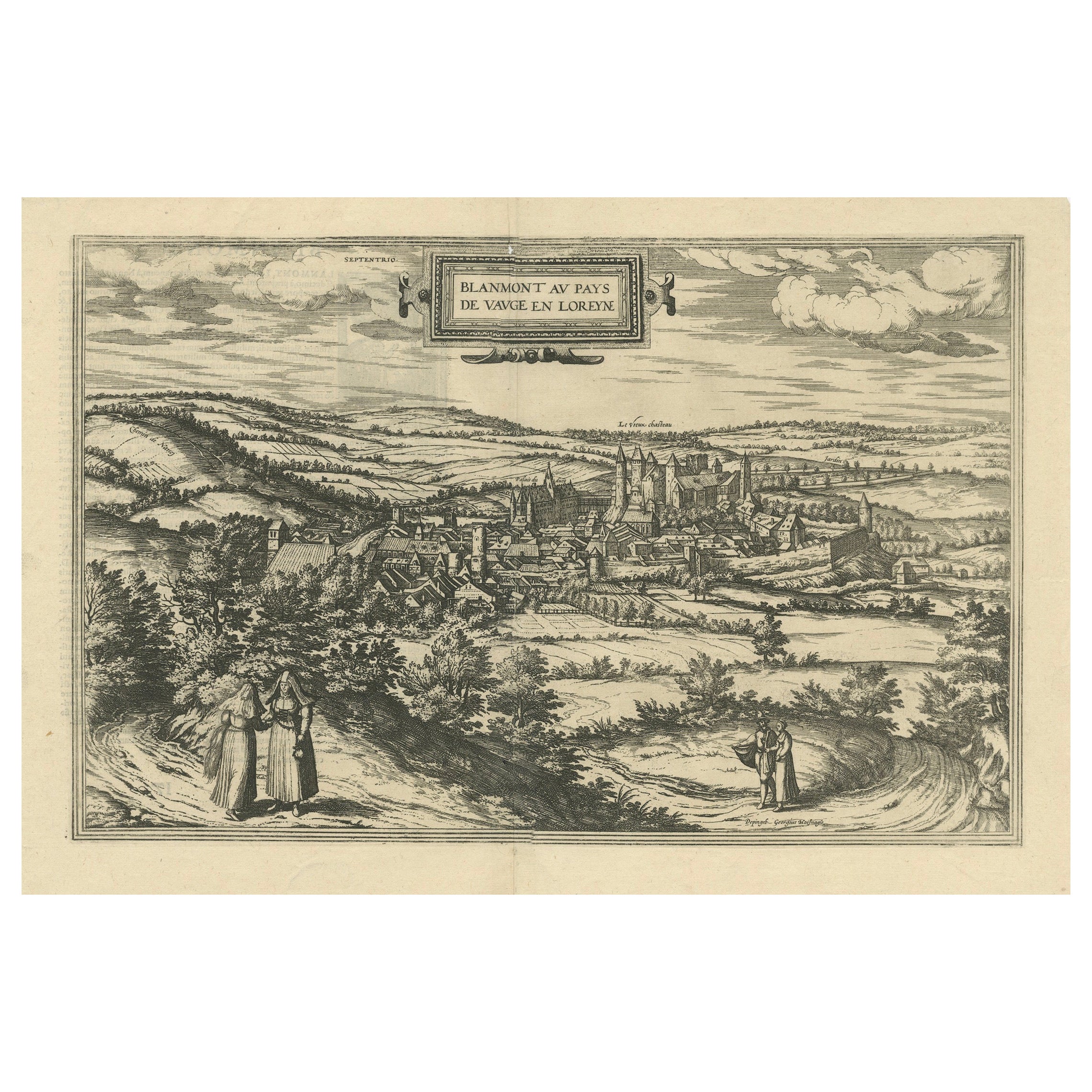
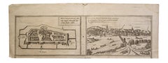
View AllBird's-Eye View of Blâmont in Lorraine by Braun and Hogenberg, 1597
Located in Langweer, NL
Title: Bird's-Eye View of Blâmont in Lorraine by Braun and Hogenberg, 1597
This copperplate engraving, published in 1597 by Braun and Hogenberg, depicts a bird's-eye view of the t...
Category
Antique 16th Century Maps
Materials
Paper
$401 Sale Price
30% Off
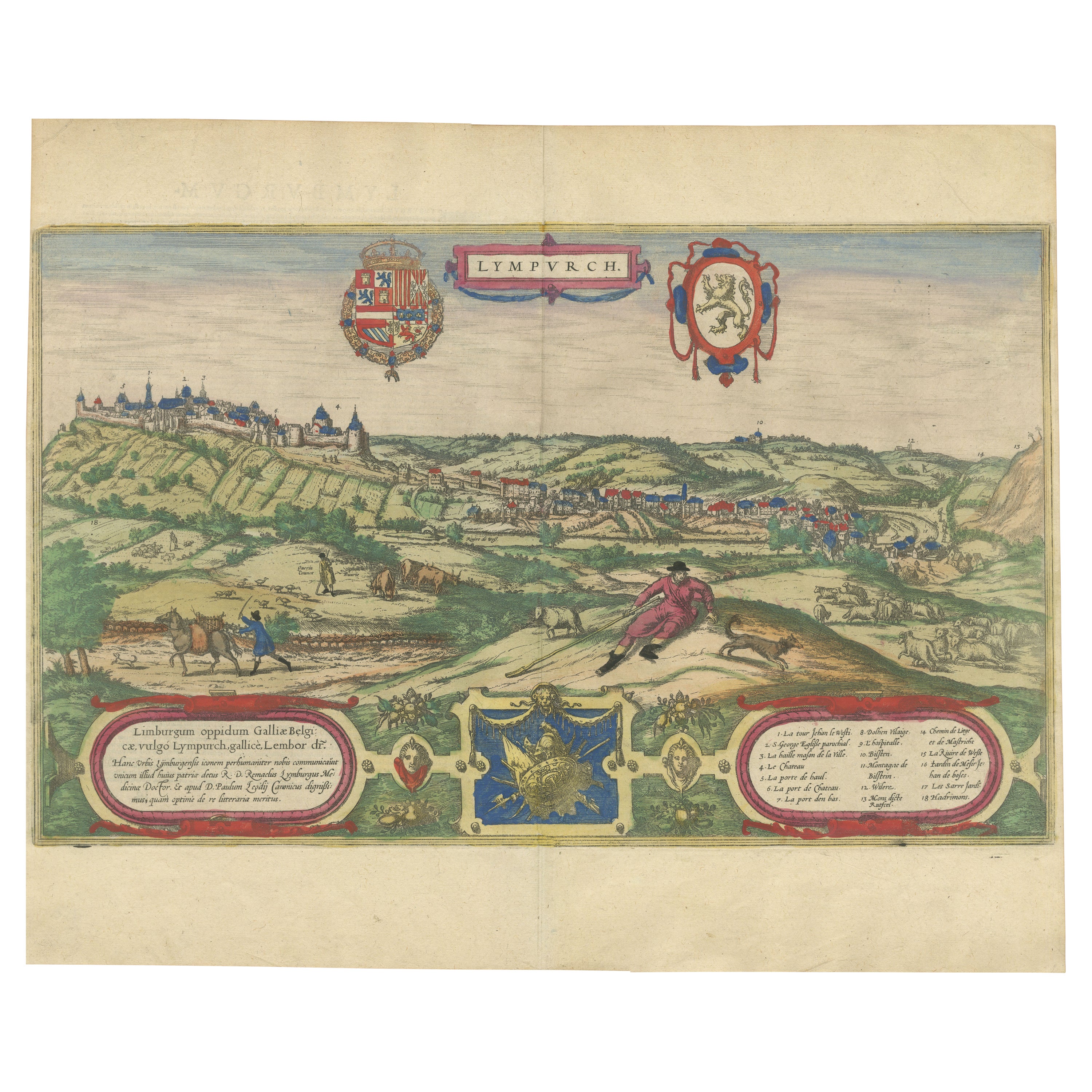
Limburg Cityscape 1580: Historical Copper Engraving by Braun and Hogenberg
Located in Langweer, NL
Title: Limburgum Oppidum Galliae Belgicae, vulgo Lympurch, gallicè, Lembor Dr.
Type: Print (Copper Engraving)
Circa 1580
Technique: Colored Copper Engraving
Medium: Handmade Paper
S...
Category
Antique 16th Century German Maps
Materials
Paper

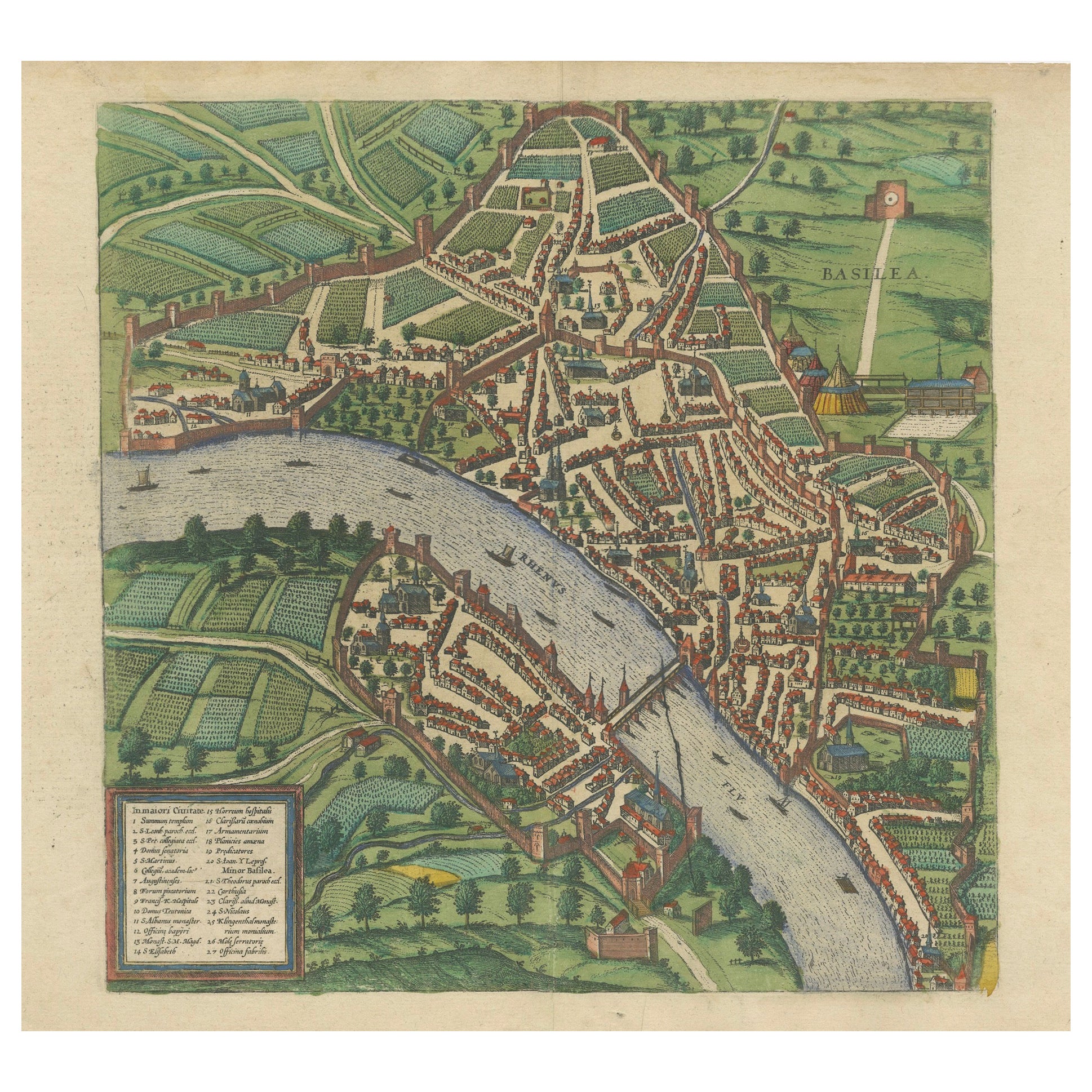
Bird’s-Eye View of Basel from Braun & Hogenberg’s Civitates Orbis Terrarum, 1575
Located in Langweer, NL
Bird’s-Eye View of Basel from Braun & Hogenberg’s "Civitates Orbis Terrarum" (Circa 1572-1617)
This highly detailed map of Basel is a bird's-eye view, originally based on Sebastian Münster’s map...
Category
Antique 16th Century Maps
Materials
Paper
$1,148 Sale Price
20% Off
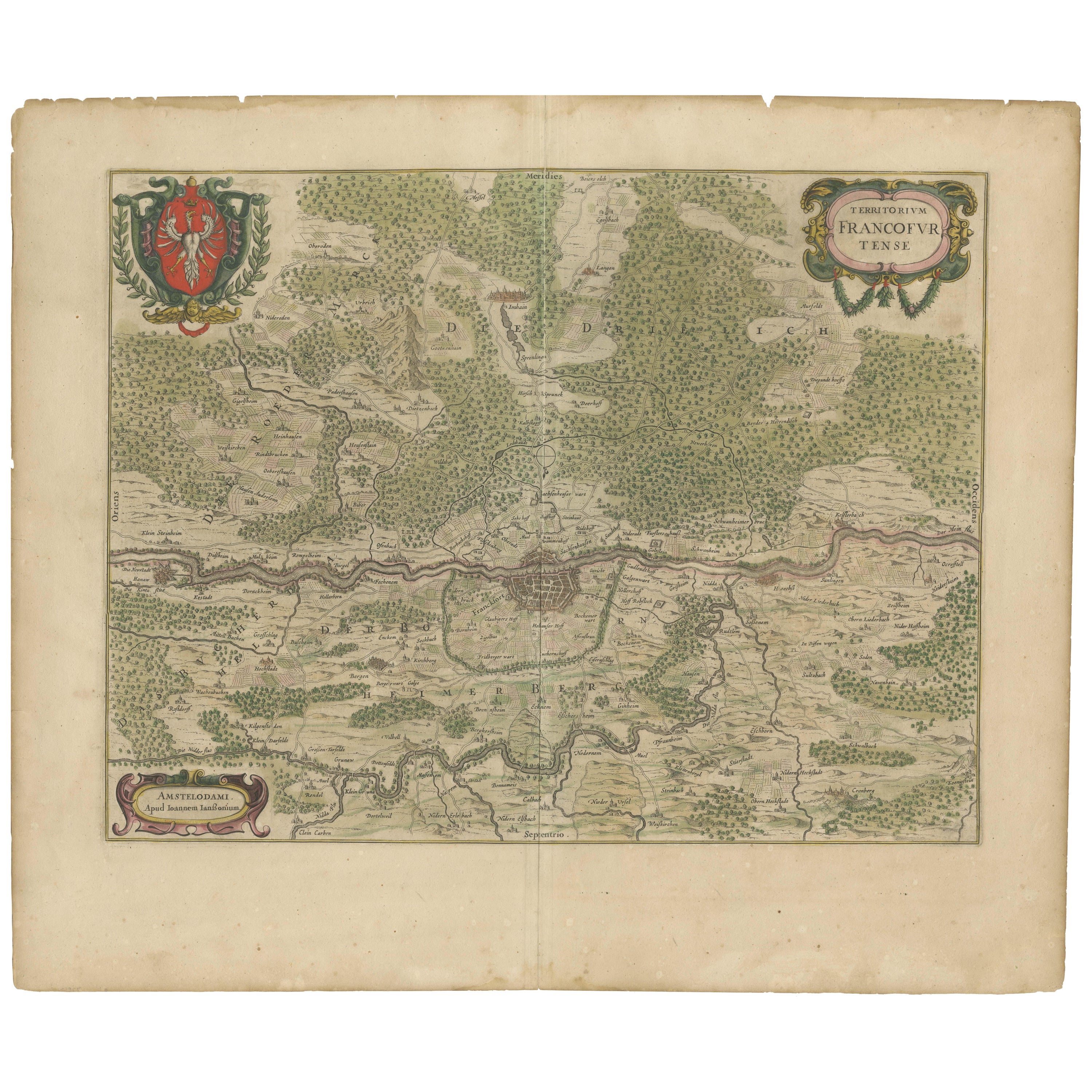
Antique Map of the Frankfurt Region by Johannes Janssonius, Hand-Colored, C.1650
Located in Langweer, NL
Antique Map of the Frankfurt Region by Johannes Janssonius circa 1650 Hand-Colored
This rare and beautifully detailed antique map titled Territorium Francofurtense depicts the reg...
Category
Antique 1650s Maps
Materials
Paper
Engraving of St. Gallen and its Monastery, from Civitates Orbis Terrarum (1575)
Located in Langweer, NL
Description of the Engraving: Braun & Hogenberg’s "S. Galli Opp. et Monasterium Heluetiorum" from Civitates Orbis Terrarum (1575)
This is an original, hand-colored copper engraving ...
Category
Antique 16th Century Maps
Materials
Paper
$658 Sale Price
20% Off
Early Woodcut Bird's Eye View of Rouffach, France, by Sebastian Münster, 1554
Located in Langweer, NL
Early Woodcut Bird's Eye View of Rouffach, France, by Sebastian Münster, 1554
Description: This rare 1554 woodcut is a bird's eye view of Rouffach, a town in the Haut-Rhin departmen...
Category
Antique 16th Century Maps
Materials
Paper
You May Also Like
Frankfort, Germany: A 16th Century Hand-colored Map by Braun & Hogenberg
By Franz Hogenberg
Located in Alamo, CA
This is a 16th century original hand-colored copperplate engraved map of Frankfort, Germany entitled "Francenbergum, vel ut alij Francoburgum Hassiae Opp" by Georg Braun & Franz Hogenberg, from their famous city atlas "Civitates Orbis Terrarum", published in Cologne, Germany in 1595.
This is an English translation of an excerpt from the original text in the atlas:
"Frankenberg or, according to others, Francoburgum, a town in Hesse. Charlemagne vested the town of Frankenberg with many freedoms and privileges, which it still enjoys to this day, and on account of its valiant and victorious soldiers awarded a signet, upon which there formerly appeared a golden castle with a tower, together with the letter F and a golden crown.
Frankenberg, seen here from the northeast, lies on a hill above the River Eder. The hillside is covered with fields neatly separated by bushes and fences. Soaring above the town is the massive Liebfrauenkirche, which was modelled on St Elizabeth's church in Marburg. The New Town was founded in 1335 at the foot of the hill (right) and merged with the Old Town as late as 1556. Frankenberg was founded by Conrad of Thuringia in 1233/34 to prevent the archbishops of Mainz from expanding their sphere of influence...
Category
16th Century Old Masters Landscape Prints
Materials
Engraving

View of Meissen, Germany: A 16th Century Hand-colored Map by Braun & Hogenberg
By Franz Hogenberg
Located in Alamo, CA
This is a 16th century original hand-colored copperplate engraved map of View of View of Meissen, Germany entitled "Misena Hermun Duvorum Urbs" by Georg Braun & Franz Hogenberg, from their famous city atlas "Civitates Orbis Terrarum", published in Cologne, Germany in 1575.
The map depicts a side view and bird's-eye view, looking across the Elbe River (labelled Albis Fluvius on the map; White River in Latin) from the northeast. In the foreground are three women in conversation on a hill above the city, along with a man and a woman in conversation by a road, all dressed in contemporary costumes of the upper class. A coat-of-arms is present in each upper corner. A great castle sits atop a hill in the background on the left. Meissen grew up around Albrechtsburg castle, built by Emperor Henry I around AD 929, and was granted a municipal charter at the end of the 12th century. From 1471 onwards, the castle complex was reconstructed as the residence of the Saxon electors on the northeast corner of the Domberg (Cathedral Hill). Meissen cathedral is a Gothic hall church begun c. 1270; in 1413 a bolt of lightning destroyed its west towers, which were replaced only in the 20th century. Meissen lies to the northwest of Dresden, Germany in Saxony. Meissen is famous for its Meissen porcelain and the Albrechtsburg castle
The following is an English translation of an excerpt from Braun's description of the city: "This city is surrounded by very many rivers, to the east flows the Elbe, to the south the Triebisch, to the west are the mountains, to the north the Meisse, after which the city is said to be named. The city is well-situated in its surroundings, the navigable rivers, the mountains and the healthy air. Around the city there is a good land to grow grain, fertile vineyards on the hillsides and without doubt the mountains are not without ore, for one mile away, up the Elbe, is Scharfenberg, where silver and lead ore are mined.."
References: Van der Krogt 4, 2684; Taschen, Braun and Hogenberg...
Category
16th Century Old Masters Landscape Prints
Materials
Engraving

Map of Wittemberg and Frankfurt- by G. Braun and F. Hogenberg - 16th Century
By Franz Hogenberg
Located in Roma, IT
This Map of Wittemberg and Frankfurt (ancient names: Wittenburga - Francfordiensis) is an original etching realized by George Braun and Franz Hogenberg as part of the famous Atlas "C...
Category
16th Century Modern Figurative Prints
Materials
Etching
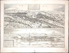
Prague and Egra, Antique Map from "Civitates Orbis Terrarum" - 1572-1617
By Franz Hogenberg
Located in Roma, IT
Braun G. & Hogenberg F., Praga, Egra, from the collection Civitates Orbis Terrarum, Cologne, T. Graminaeus, 1572-1617. Image dimensions: 39.5 x 47.5 cm. Dimensions: 41 x 52.5 cm.
Wo...
Category
16th Century Landscape Prints
Materials
Etching
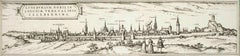
Luneburg, Map from "Civitates Orbis Terrarum" - by F.Hogenberg - 1575
By Franz Hogenberg
Located in Roma, IT
"Luneburg", from the collection "Civitates Orbis Terrarum", Cologne, T. Graminaeus, 1575.
The “Civitates Orbis Terrarum” (Atlas of Cities of the World) was the second oldest print...
Category
16th Century Figurative Prints
Materials
Etching, Aquatint
Nuremberg, Map from "Civitates Orbis Terrarum" - by F. Hogenberg - 1575
By Franz Hogenberg
Located in Roma, IT
Braun G., Hogenberg F., Nurnberg or Nuremberg, from the collection Civitates Orbis Terrarum, Cologne, T. Graminaeus, 1572-1617.
Very fine B/W aquatint showing a view of Nuremberg. Strongly influenced by Hartmann Schedel's Nuremberg Chronicles...
Category
16th Century Figurative Prints
Materials
Etching, Aquatint
More Ways To Browse
G Harvey Prints
Grote Bonte Specht
Group Of Seven Canada
Guangzhou Antique Market
H Herrmann Furniture
Harrison Fisher Antique Prints
Herrings Fox Hunting
Ike Ude
Inagaki Nenjiro
J And E Gould
J Harris Engraving
Jack Youngerman Lithograph
Jean Lurcat Zodiac
John Gould Toucans
John Kelly Lithographs
Jones Toile
Julije Knifer
Kanchou Wallpaper