Items Similar to Von Reilly Map of the Russian Empire, 1796


Want more images or videos?
Request additional images or videos from the seller
1 of 8
Von Reilly Map of the Russian Empire, 1796
$1,200
£902.89
€1,043.12
CA$1,695.91
A$1,841.43
CHF 975.17
MX$22,570.68
NOK 12,068.15
SEK 11,403.76
DKK 7,785.44
About the Item
A map of the Russian Empire in Europe by Von Reilly. Published in Vienna, 1796.
32 inches wide by 24 ½ inches tall
- Dimensions:Height: 24.5 in (62.23 cm)Width: 32 in (81.28 cm)Depth: 0.75 in (1.91 cm)
- Materials and Techniques:
- Place of Origin:
- Period:1790-1799
- Date of Manufacture:1796
- Condition:Wear consistent with age and use. Good overall with some distressing including foxing, toning and paper cockling.
- Seller Location:Savannah, GA
- Reference Number:1stDibs: LU9288243436922
About the Seller
5.0
Platinum Seller
Premium sellers with a 4.7+ rating and 24-hour response times
Established in 2013
1stDibs seller since 2023
91 sales on 1stDibs
Typical response time: <1 hour
- ShippingRetrieving quote...Shipping from: Savannah, GA
- Return Policy
Authenticity Guarantee
In the unlikely event there’s an issue with an item’s authenticity, contact us within 1 year for a full refund. DetailsMoney-Back Guarantee
If your item is not as described, is damaged in transit, or does not arrive, contact us within 7 days for a full refund. Details24-Hour Cancellation
You have a 24-hour grace period in which to reconsider your purchase, with no questions asked.Vetted Professional Sellers
Our world-class sellers must adhere to strict standards for service and quality, maintaining the integrity of our listings.Price-Match Guarantee
If you find that a seller listed the same item for a lower price elsewhere, we’ll match it.Trusted Global Delivery
Our best-in-class carrier network provides specialized shipping options worldwide, including custom delivery.More From This Seller
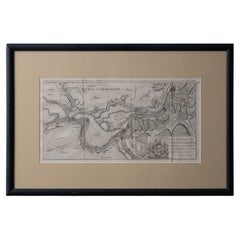
View AllBattle of Grocka Campaign Map, 1753 - James Oglethorpe, John Lindsay, Henry Köpp
Located in Savannah, GA
A campaign map of the Battle of Grocka, 1753.
Drawn and engraved by Henry Köpp for the journals of John Lindsay, 20th Earl of Crawford and dedicated to James Oglethorpe.
sight:...
Category
Antique 1750s British Prints
Materials
Glass, Wood, Paper
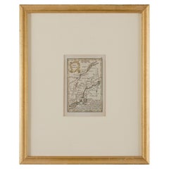
John Gibson - Map of New England
Located in Savannah, GA
A miniature map of New England from John Gibson’s The Atlas Minimus published in 1758.
John Gibson worked in London from 1748-1773 as a geographer and engraver, producing numerous ...
Category
Antique 1750s British Other Prints
Materials
Glass, Paper
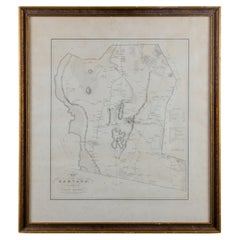
Silas Holman Map of Harvard
Located in Savannah, GA
A framed historic map of Harvard, as surveyed in 1831 by Silas Holman, reproduced circa 1920s.
frame: 29 by 32 inches
Category
Vintage 1920s Other Prints
Materials
Glass, Wood, Paper
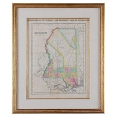
Map of Mississippi Carey & Lea, 1822
Located in Savannah, GA
Published in Philadelphia for the “Complete Historical, Chronological and Geographical American Atlas” by Henry Carey and Issac Lea, the map depicts Mississippi as it existed in 1822...
Category
Antique 1820s American Other Prints
Materials
Glass, Wood, Paper
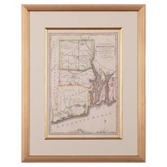
The State of Rhode Island Map - Caleb Harris & Harding Harris, 1818
Located in Savannah, GA
Mathew Carey
(American/Philadelphia, 1760-1839)
The State of Rhode Island compiled from the surveys and observations of Caleb Harris by Harding Harris. Engraving with hand-coloring...
Category
Antique 1810s American Other Prints
Materials
Glass, Wood, Paper
1872 Map of Hudson, Union and Essex Counties, New Jersey
Located in Savannah, GA
A hand-colored topographical map of New Jersey’s Hudson, Union and Essex Counties from the Atlas of New Jersey by F.W. Beers, published in 1872.
sight 15 by 22½ inches
frame 20 by...
Category
Antique 1870s American Prints
Materials
Glass, Wood, Paper

You May Also Like
Antique Map of the Russian Empire in Europe by Vaugondy, 1750
Located in Langweer, NL
Antique map titled 'Partie Occidentale de l'Empire de Russie (..)'. Detailed map of the western part of Russia, extending south to the Caspian and east to Irkurkoy and Ilimskoy.
A...
Category
Antique 18th Century Maps
Materials
Paper

$325 Sale Price
20% Off
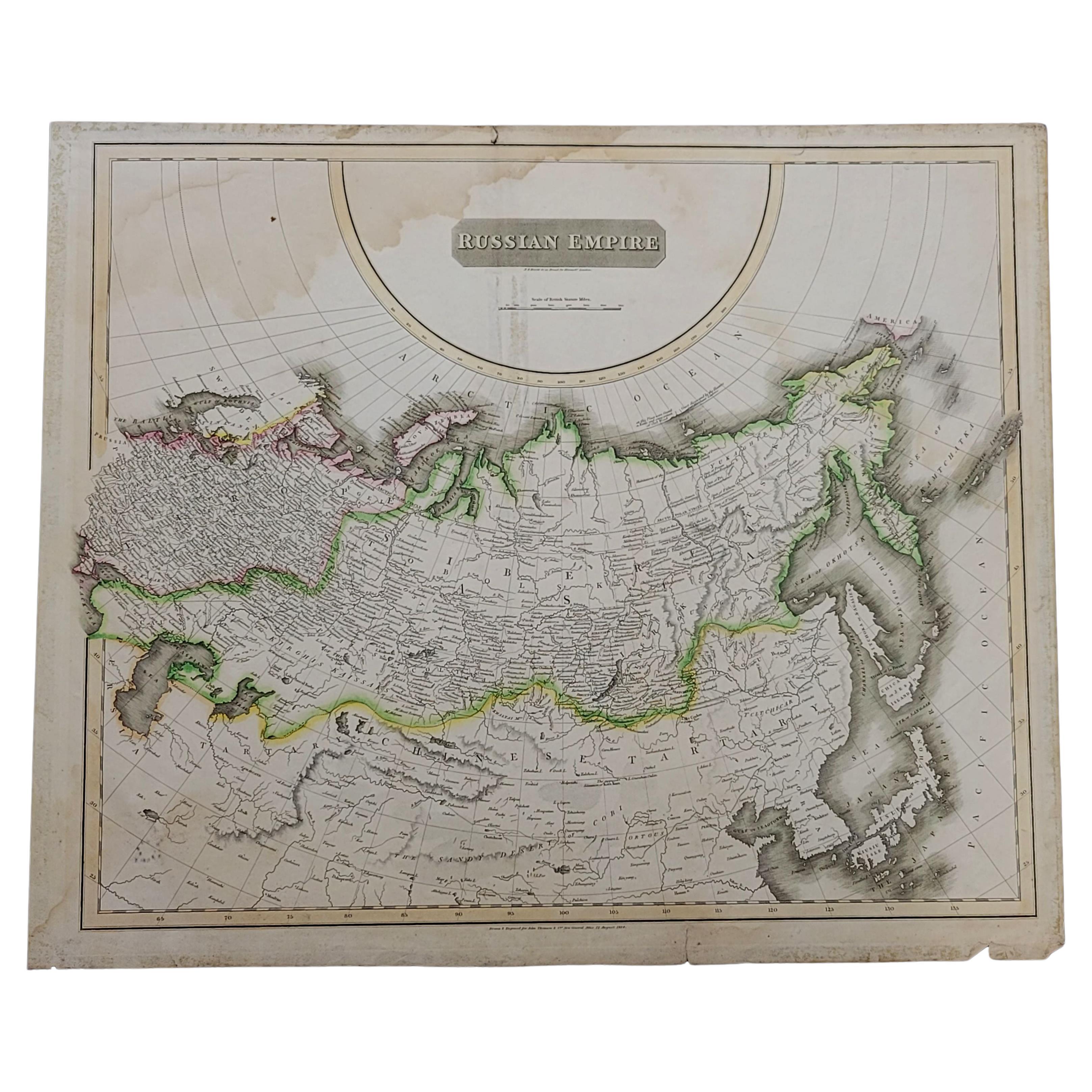
1814 Map of "Russian Empire" Ric.r032
Located in Norton, MA
1814 Map of
"Russian Empire"
Ric.r032
Russian Empire. Description: This is an 1814 John Thomson map of the Russian Empire. The map depicts the region from the Baltic Sea, Prussia, and Sweden to the Aleutian Islands and from the Arctic Ocean to the Yellow River. Highly detailed, myriad cities, towns, and villages are labeled throughout, including St. Petersburg, Moscow, Minsk, Kiev, and Kharkov. Rivers and mountain ranges are also identified, as are islands and numerous locations along the coastlines. It is important to note that the long-disputed sea between Korea and Japan is identified as the 'Sea of Japan.
Historical Context:
In 1815, Tsarist Russia emerged from the Napoleonic Wars economically insolvent and politically fearful of the Revolutionary fervor that had just swept through Europe. In order to shore up Russia's economic position, the Tsars began an aggressive series of expansions into the Caucuses and Central Asia that would vastly increase the landmass of the Russian Empire.
Publication History
Thomson maps are known for their stunning color, awe inspiring size, and magnificent detail. Thomson's work, including this map, represents some of the finest cartographic art...
Category
Antique 19th Century Unknown Maps
Materials
Paper

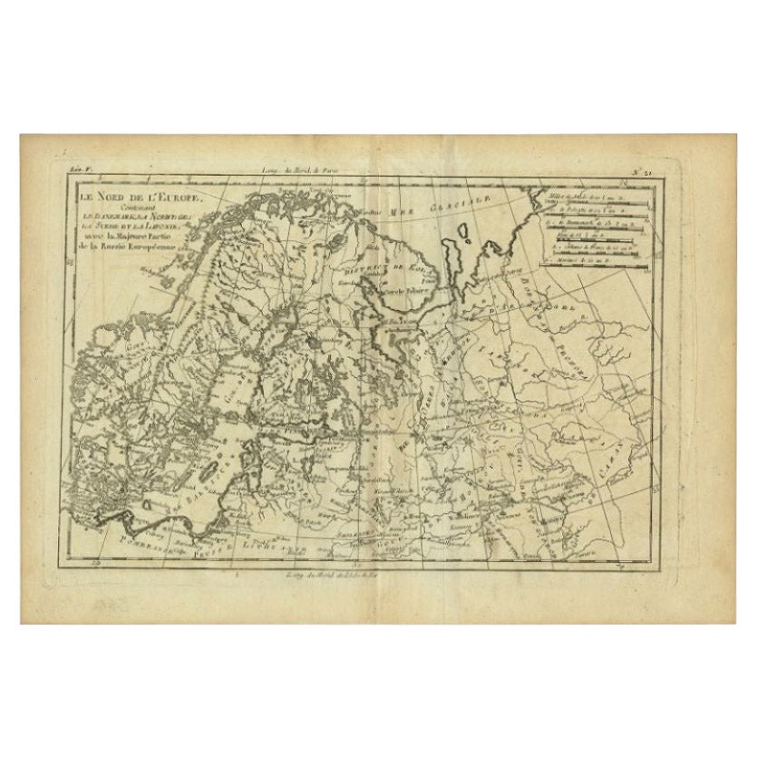
Antique Map of Northern Europe by Bonne, c.1780
Located in Langweer, NL
Antique map titled 'Le Nord de L'Europe, Contenant Le Danemark, La Norwege; La Suede et La Laponie avec la Majeure Partie de al Russie Europeenne.' Map of Northern Europe and Europea...
Category
Antique 18th Century French Maps
Materials
Paper
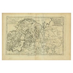
$113 Sale Price
30% Off
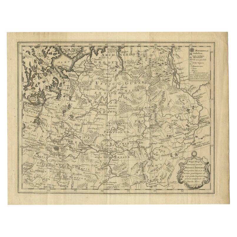
Antique Map of Part of Russia by Spyk, c.1740
Located in Langweer, NL
Antique map titled 'Mappa Geogr: Continens partem Russici Imperii (..)'. Old map of part of Russia including the city of Moscow, Vologda, Tobolsk and others. Source unknown, to be de...
Category
Antique 18th Century Maps
Materials
Paper
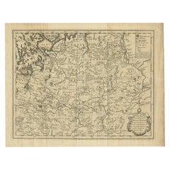
$146 Sale Price
20% Off
Antique Map of Russia in Europe by T. Kitchin, circa 1770
Located in Langweer, NL
Antique map titled 'Russia or Moscovy in Europe, drawn from the latest authorities (..)'. An interesting and attractive early 19th century map of Russia in Europe which was engraved ...
Category
Antique Late 18th Century Maps
Materials
Paper

$153 Sale Price
20% Off
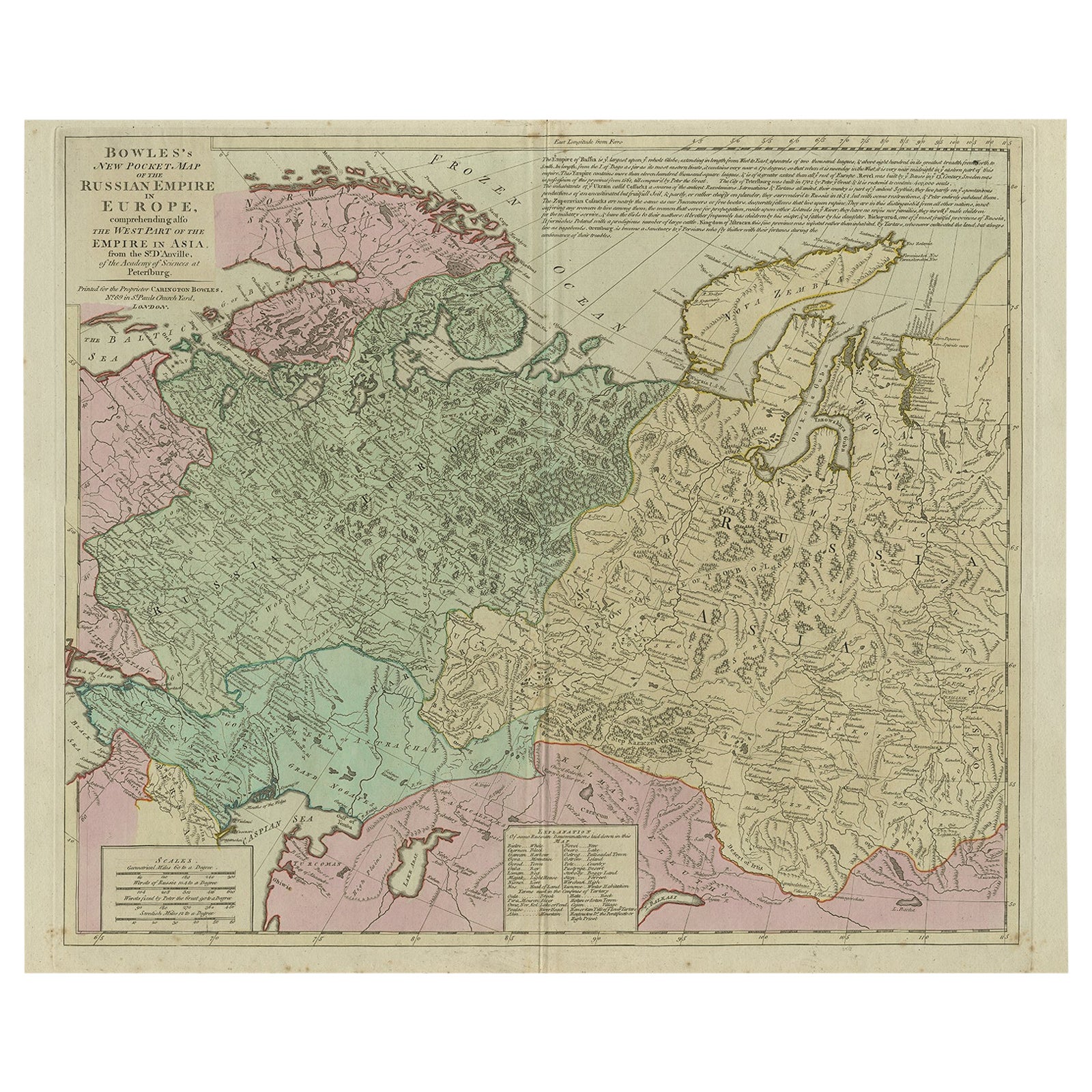
Antique Map of the Russian Empire in Europe, ca.1780
Located in Langweer, NL
Description: Antique map titled 'Bowles's New Pocket Map of the Russian Empire in Europe, Comprehending the West Part of the Empire in Asia' Large and detai...
Category
Antique 1780s Maps
Materials
Paper

$813 Sale Price
20% Off
More Ways To Browse
Maximilian Design
Medici Lion
Medieval Manuscripts
Meeks Vintage
Metal Art Owl
Metal Insects
Metal Pig
Mexican Baroque
Mexican Hardware
Mid Century Wood Deer
Midcentury Mastercraft Chest Of Drawers
Midcentury Modern Homecrest
Military Lamps
Modern Japanese Screen
Monterey Rancho Furniture
Morocco Map
Murano Birds On A Branch
Murano Glass Sculpture Head