Items Similar to Accurata totius Archipelagi et Graeciae...- Etching by Frederick de Wit - 1680ca
Want more images or videos?
Request additional images or videos from the seller
1 of 5
Frederick de WitAccurata totius Archipelagi et Graeciae...- Etching by Frederick de Wit - 1680ca 1680 ca
1680 ca
$1,425.10
£1,054.99
€1,200
CA$1,963.45
A$2,187.56
CHF 1,142.01
MX$26,559.89
NOK 14,354.31
SEK 13,568.31
DKK 9,137.01
About the Item
This double-page etching with contemporary coloring, entitled Accurata totius Archipelagi et Graeciae Universae Tabula, was realized by the cartographer Frederick de Wit for the famous Atlas published in Amsterdam in ca. 1680.
The state of preservation is fair: central fold reinforced in antiquity on the reverse, stains and browning of the paper.
Folio, measures ca. cm 51,5x59,8
Inscription on the reverse "Foglio 23 / Grecia"
Frederick de Wit was a cartographer and map-seller who was best known for his atlases and his Dutch town maps. His maps were known for their accuracy and detail, and contributed significantly to the documentation and understanding of the lands explored and discovered in the 17th century. His work had a considerable influence on the diffusion of geographical and cartographic knowledge of the time.
- Creator:Frederick de Wit (1630 - 1706, Dutch)
- Creation Year:1680 ca
- Dimensions:Height: 20.28 in (51.5 cm)Width: 23.55 in (59.8 cm)Depth: 0.04 in (1 mm)
- Medium:
- Movement & Style:
- Period:1680-1689
- Framing:Framing Options Available
- Condition:Insurance may be requested by customers as additional service, contact us for more information.
- Gallery Location:Roma, IT
- Reference Number:Seller: T-1549021stDibs: LU650316393252
Frederick de Wit
Frederick De Wit (1629-1706) was an engraver, cartographer and map dealer who ran a prominent and productive printing business in Amsterdam, founded in 1654 and initially called The Three Crabs and later The White Chart. He published his first atlas in 1662. In 1695 he purchased a large collection of the plates of the prestigious Blaeu publishing business. After his death in 1706, his wife Maria continued in the business for four years before selling it at the auction. A majority of the plates were purchased by Pieter Mortier. His thriving and growing business eventually became Covens & Mortier, one of the largest and most successful cartography and printing businesses of the eighteenth century.
About the Seller
4.9
Platinum Seller
Premium sellers with a 4.7+ rating and 24-hour response times
1stDibs seller since 2017
7,680 sales on 1stDibs
Typical response time: 3 hours
- ShippingRetrieving quote...Shipping from: Grasse, France
- Return Policy
Authenticity Guarantee
In the unlikely event there’s an issue with an item’s authenticity, contact us within 1 year for a full refund. DetailsMoney-Back Guarantee
If your item is not as described, is damaged in transit, or does not arrive, contact us within 7 days for a full refund. Details24-Hour Cancellation
You have a 24-hour grace period in which to reconsider your purchase, with no questions asked.Vetted Professional Sellers
Our world-class sellers must adhere to strict standards for service and quality, maintaining the integrity of our listings.Price-Match Guarantee
If you find that a seller listed the same item for a lower price elsewhere, we’ll match it.Trusted Global Delivery
Our best-in-class carrier network provides specialized shipping options worldwide, including custom delivery.More From This Seller
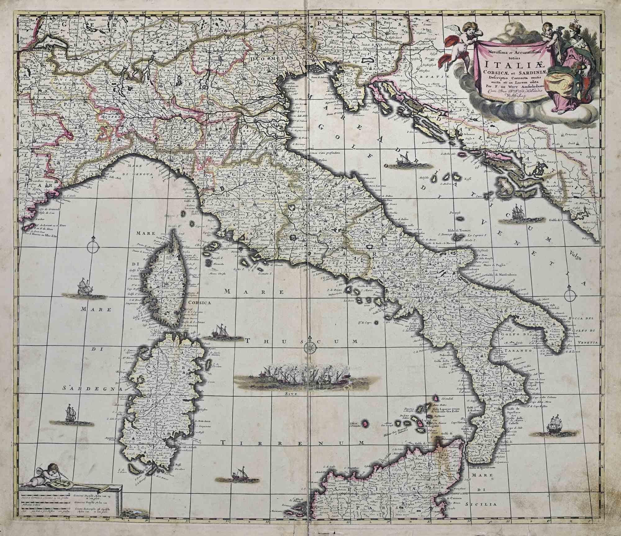
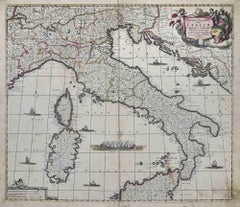
View AllNovissima et Accuratissima Totius.. - Etching by Frederick de Wit - 1680ca
By Frederick de Wit
Located in Roma, IT
This double-page etching with contemporary coloring, entitled Novissima et Accuratissima totius Italiae, Corsicae et Sardiniae, was realized by the cartographer Frederick de Wit for ...
Category
1680s Modern Figurative Prints
Materials
Etching
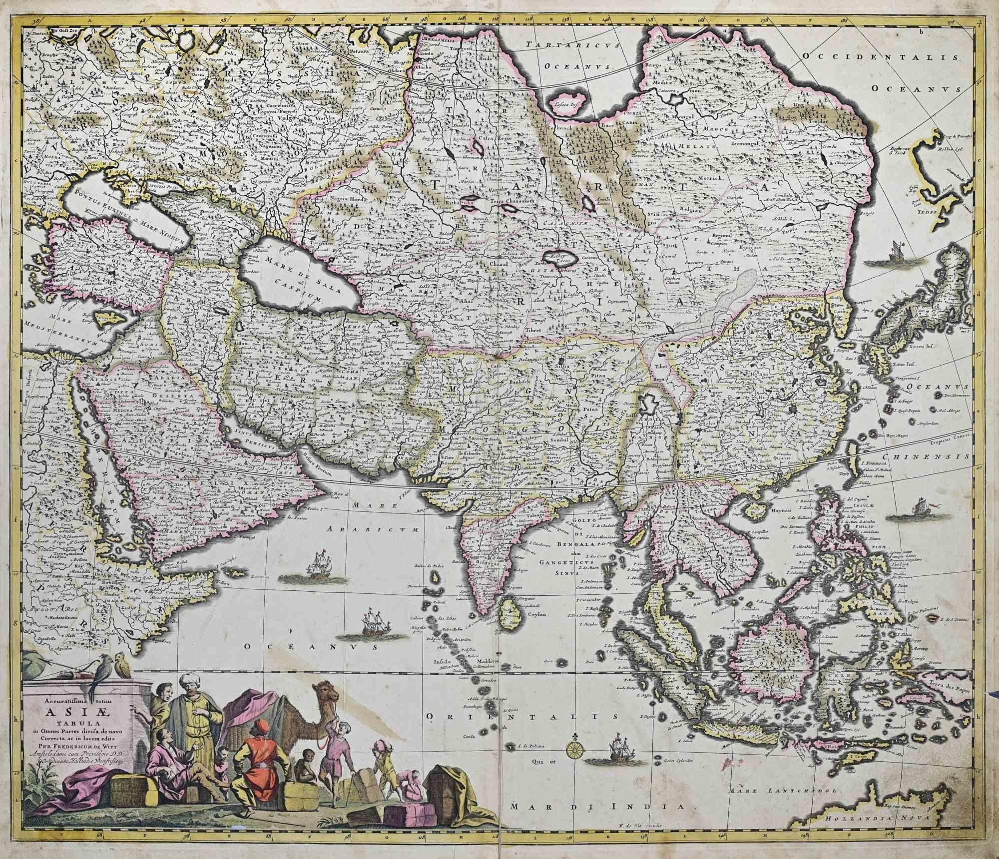
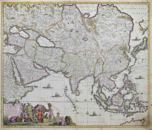
Accuratissima Totius Asiae Tabula - Etching by Frederick de Wit - 1680 ca
By Frederick de Wit
Located in Roma, IT
This double-page etching with contemporary coloring, entitled Accuratissima totius Asiae Tabula, was realized by the cartographer Frederick de Wit for the famous Atlas published in A...
Category
1680s Modern Figurative Prints
Materials
Etching

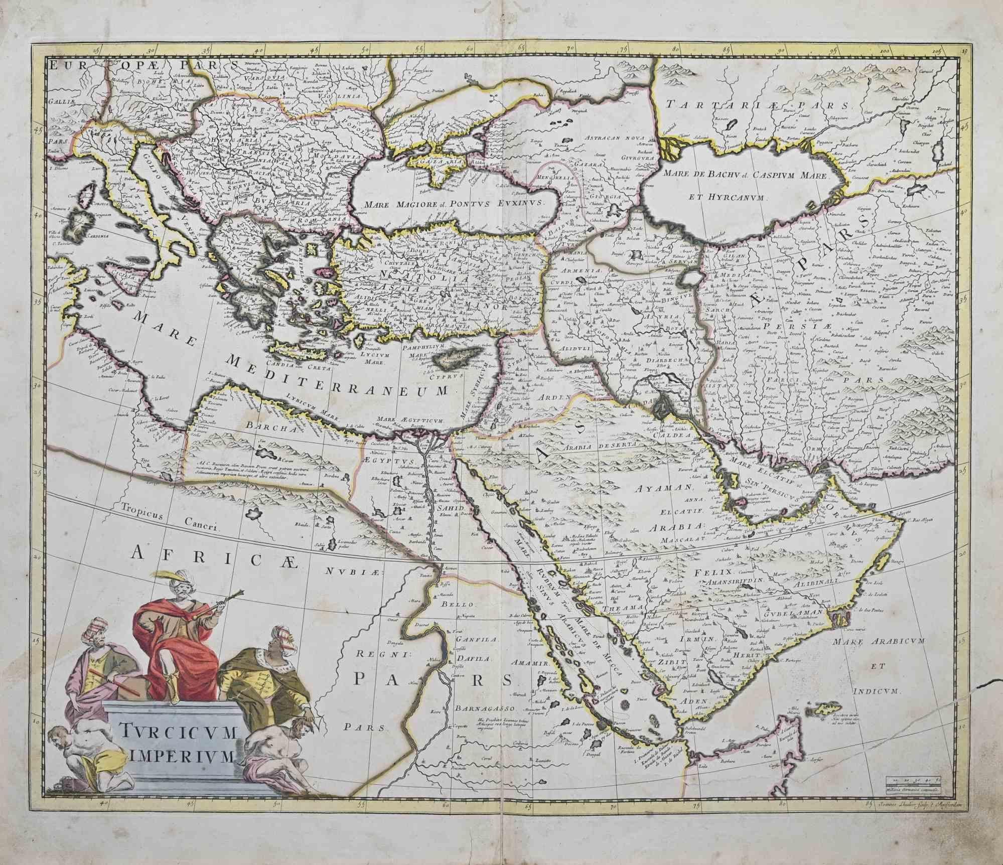
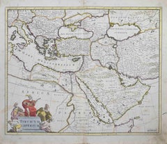
Turcicum Imperium - Etching by Frederick de Wit - 1680ca
By Frederick de Wit
Located in Roma, IT
This double-page etching with contemporary coloring, entitled Turcicum Imperium, was realized by the cartographer Frederick de Wit for the famous Atlas published in Amsterdam in ca. ...
Category
1680s Modern Figurative Prints
Materials
Etching
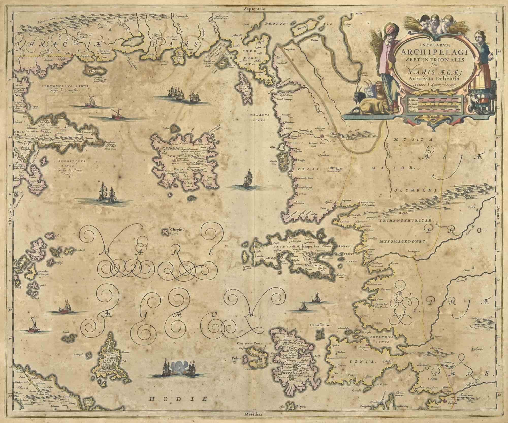
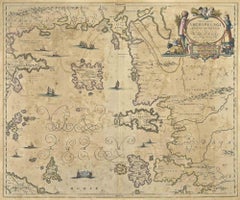
Archipelagus Septentrionalis - Etching by Johannes Janssonius - 1650s
By Johannes Janssonius
Located in Roma, IT
Archipelagus Septentrionalis is an ancient map realized in 1650 by Johannes Janssonius (1588-1664).
Good conditions.
From Atlantis majoris quinta pars, Orbem maritimum [Novus Atlas...
Category
1650s Modern Figurative Prints
Materials
Etching
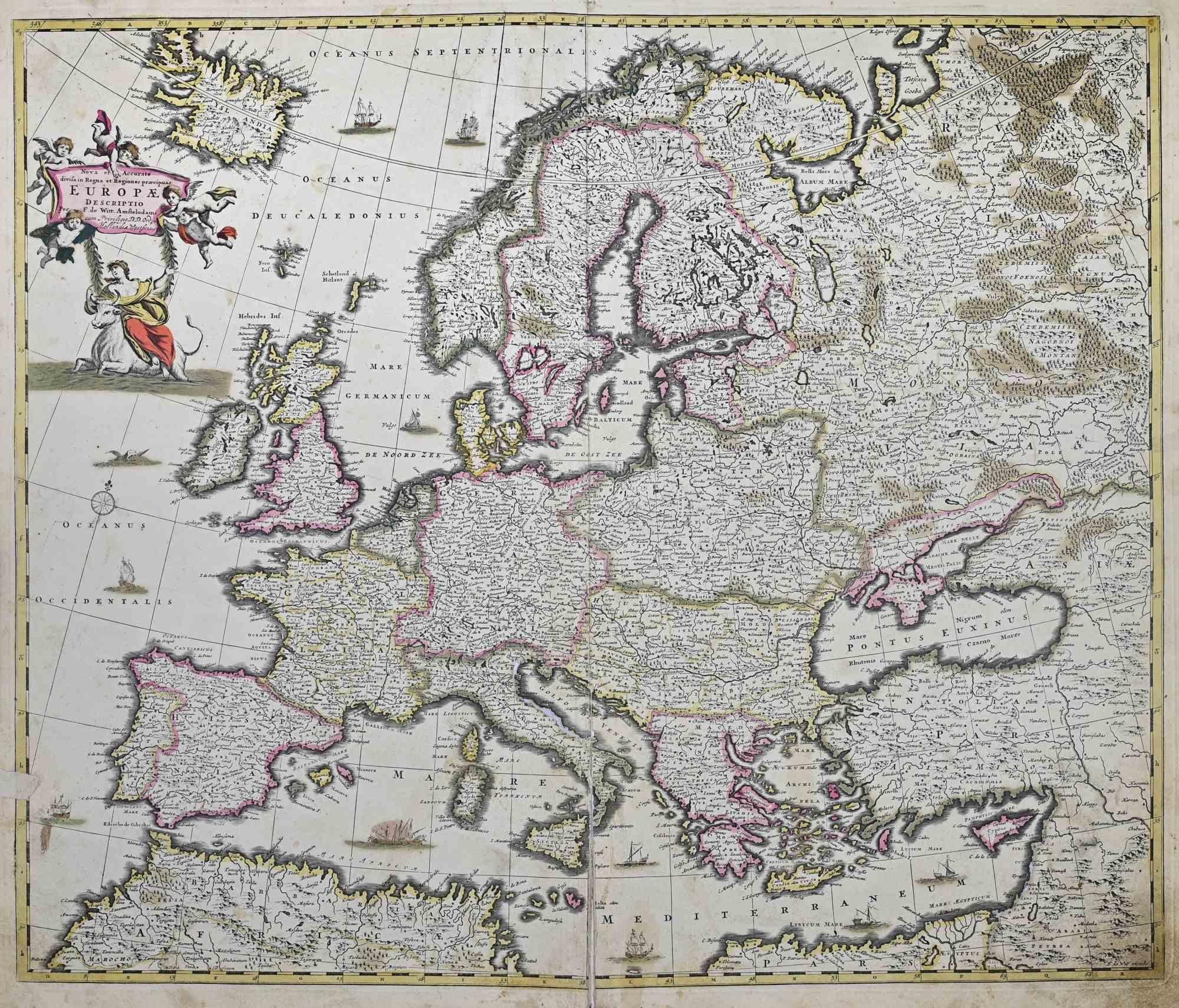
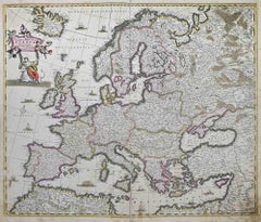
Nova et Accurata Totius Europae Descriptio- Etching by Frederick de Wit - 1680ca
By Frederick de Wit
Located in Roma, IT
This double-page etching with contemporary coloring, entitled Nova et Accurata Totius Europae Descriptio, was realized by the cartographer Frederick de Wit for the famous Atlas publi...
Category
1680s Modern Figurative Prints
Materials
Etching
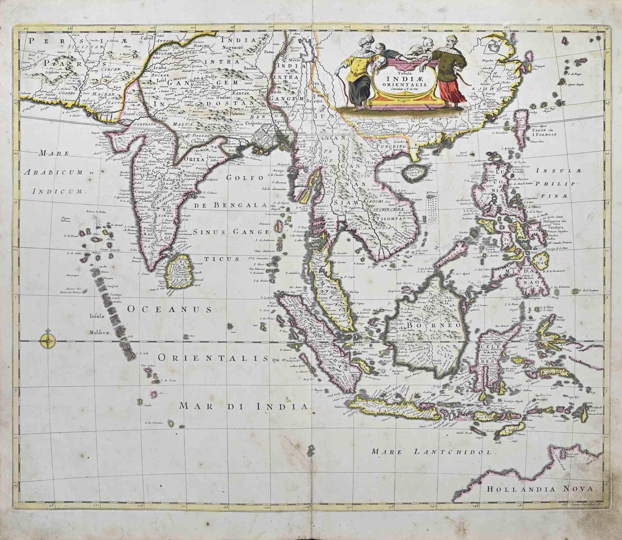
Tabula Indiae Orientalis - Etching by Frederick de Wit - 1680ca
By Frederick de Wit
Located in Roma, IT
This double-page etching with contemporary coloring, entitled Tabula Indiae orientalis, was realized by the cartographer Frederick de Wit for the famous Atlas published in Amsterdam ...
Category
1680s Modern Figurative Prints
Materials
Etching

You May Also Like
Antique Map of Greece by Allard (c.1698)
Located in Langweer, NL
Antique map titled 'Hellas seu Graecia Universa' Detailed map of Greece, with Crete, the Aegean Islands, and part of Turkey. With two cartouches, compass rose and scale. Carolus Alla...
Category
Antique Late 17th Century Maps
Materials
Paper

$931 Sale Price
20% Off
Southern & Eastern Europe: A Large 17th C. Hand-colored Map by Sanson & Jaillot
By Nicholas Sanson d'Abbeville
Located in Alamo, CA
This large hand-colored map entitled "Estats de L'Empire des Turqs en Europe, ou sont les Beglerbeglicz our Gouvernements" was originally created by Nicholas Sanson d'Abbeville and this version was published by Hubert Jaillot in "Atlas Nouveau" in Paris in 1692. It depicts the territories of the Ottoman Empire in Europe, predominantly Eastern Europe. Highlights include, the Mediterranean Sea, the Adriatic Sea, the Black Sea, the Dalmation Coast including present day Croatia, Bosnia and Herzegovina, Montenegro, Serbia, Slovenia, Italy, Greece, North Macedonia, Turkey, Romania, Hungary, Albania, Kosovo, Bulgaria, Transylvania, Moldova and southern portions of France, Switzerland, Germany, and Poland..
The map consists of two sheets joined as one along a vertical joint. The map has original hand-coloring. It is printed on antique hand-made laid, chain-linked paper with wide margins. The sheet measures 24.88" high and 38" wide. There is a central vertical joint, as issued. The map is in very good condition.
Nicholas Sanson d'Abbeville (1600-1667) was one of the greatest French cartographather of French cartography. Sanson opened his first printing business in Paris in 1638. The king recognized his skill and knowledge and made him the official geographer to the court. He eventually served two kings in this capacity. Sanson was succeeded by his sons and son...
Category
1690s Landscape Prints
Materials
Engraving

Indiarum Occidentalium Tractus Littorales cum Insulis Caribicis / Pascaert van W
By Louis Renard
Located in New York, NY
This early 18th-century engraved map was published by Louis Renard in Amsterdam. The image size is 19 x 22 " (48.3 x 55.9 cm) plus margins.
A beautifully engraved Dutch sea chart. Shown is the entire Caribbean basin including the eastern seaboard up to Cape Cod and includes Bermuda. Florida is shown with the classic flattened southeastern coast that was derived by Hessel Gerritz. Noted are the routes taken by the Spanish treasure...
Category
18th Century Other Art Style More Prints
Materials
Engraving

Persiae, Armeniae, Natoliae et Arabiae Descriptio per Frederick deWit 1666 map
Located in Paonia, CO
Map of Persiae, Armeniae, Natoliae et Arabiae Descriptio per F de Wit 1688 engraving from: Atlas Contractus Orbis Terrarum Praecipuas ac Novissimas Complectens Tabulas. Amsterdam, N. Visscher, 1656-77. (Koeman III, Vis5-8) This highly decorative map of the Middle East is by the Dutch engraver, publisher, and map seller...
Category
1660s Realist Landscape Prints
Materials
Engraving

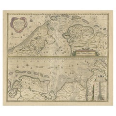
Two Original Antique Engravings with the Dutch and German North Sea Coast, c1650
Located in Langweer, NL
Antique map titled 'Nieuwe Caerte waerinne vertoont wordt de gantsche Vaert van Amsterdam over de Watten tot de stadt Hamborch toe'.
Two maps with the Dutch and German North Sea ...
Category
Antique 1650s Maps
Materials
Paper
$560 Sale Price
20% Off
Antique Map of Eastern Mediterranean and Asia Minor by a Benedictine, c.1725
Located in Langweer, NL
Antique map titled 'Byzondere Afbeelding der Landschappen, van de Apostelen bevaren en doorwandelt om het Evangelium J. C. te Prediken.' Map of the lands travelled by the Apostles to...
Category
Antique 18th Century Maps
Materials
Paper

$285 Sale Price
20% Off
More Ways To Browse
Antique Explorer
Goya Los Desastres De La Guerra
Henry Lemon
Ibrahim Kodra On Sale
J Toller
Jim Dine Bathrobe
John Register Lithographs
Kansas City Chiefs
Klezmer Musicians
Le Mont Saint Michel Vintage
Louis Vuitton 2020 Limited Edition
Max Papart Carborundum
Nike Sneakers
Nura Ulreich
Owi Posters
Picasso Hibou
Picasso La Danse
Picasso Pigeons Lithograph