Items Similar to Circa 1825 original engraving of the map of Syria by Giraldon Bovinet

Want more images or videos?
Request additional images or videos from the seller
1 of 8
Giraldon BovinetCirca 1825 original engraving of the map of Syria by Giraldon BovinetCirca 1825
Circa 1825
$1,083.77
£801.85
€900
CA$1,498.50
A$1,645.17
CHF 858.29
MX$19,908.82
NOK 10,757.30
SEK 10,136.21
DKK 6,852.63
About the Item
The circa 1825 original engraving of "Syrie" by Giraldon Bovinet, based on the work of L. Vivien, is a historically significant map that reflects early 19th-century cartographic techniques and geographic knowledge of the Eastern Mediterranean region. Published as Numéro 47 by Ménard & Desenne, prominent French publishers at the time, this engraving is part of a broader series of maps that depicted the ancient and contemporary regions of the world.
The map shows Syria (Syrie) as understood during the early 19th century, covering a broader region that includes present-day Syria, Lebanon, Israel, Palestine, and parts of Jordan. The area, referred to as Syria Propria in historical texts, was a significant territory in both biblical and classical histories, often associated with the ancient Levant and its civilizations.
Giraldon Bovinet was known for his detailed and precise engraving work, and this map exemplifies the care and craftsmanship that went into such pieces during this period. The engraving outlines various geographic features, including mountain ranges, rivers, and coastal areas. Borders are marked, with an emphasis on the division of territories within this vast region, while cities and significant locations are labeled meticulously.
The use of fine lines and hatching techniques highlights the topography of the area, giving viewers a clear sense of the terrain. The map includes longitude and latitude markers, a common practice in the era’s cartography, assisting in providing accurate geographic context. Additionally, the map is bordered with a decorative frame, which adds to its aesthetic value and reflects the neoclassical design style prevalent in early 19th-century France.
This engraving is not only a functional map but also a work of art, symbolizing the intersection of cartography, geography, and artistic expression during the period. The Ménard & Desenne publication firm played a significant role in disseminating such detailed geographic engravings, contributing to the broader European understanding of Middle Eastern regions.
As an artifact, this map serves as an important reminder of the historical and political dynamics of the time, offering insights into how Europe viewed and represented the lands of the Near East. It remains a valuable piece for both collectors of antique maps and historians interested in the geopolitical and geographic perceptions of the 19th century.
Color engraving
Middle East - Palestine - Geography - Syria
Number 47 - Ménard & Desenne
About the Seller
5.0
Gold Seller
Premium sellers maintaining a 4.3+ rating and 24-hour response times
Established in 2021
1stDibs seller since 2022
174 sales on 1stDibs
Typical response time: 2 hours
- ShippingRetrieving quote...Shipping from: PARIS, France
- Return Policy
Authenticity Guarantee
In the unlikely event there’s an issue with an item’s authenticity, contact us within 1 year for a full refund. DetailsMoney-Back Guarantee
If your item is not as described, is damaged in transit, or does not arrive, contact us within 7 days for a full refund. Details24-Hour Cancellation
You have a 24-hour grace period in which to reconsider your purchase, with no questions asked.Vetted Professional Sellers
Our world-class sellers must adhere to strict standards for service and quality, maintaining the integrity of our listings.Price-Match Guarantee
If you find that a seller listed the same item for a lower price elsewhere, we’ll match it.Trusted Global Delivery
Our best-in-class carrier network provides specialized shipping options worldwide, including custom delivery.More From This Seller
View All1864 Original illustrated planisphere - World Map - Geography
Located in PARIS, FR
Immerse yourself in the epic journey of the past with the Illustrated Historical Planisphere of 1864 by Charpentier! 🗺️ This cartographic treasure transports you through the intrica...
Category
1860s Prints and Multiples
Materials
Linen, Lithograph, Paper

1851 Original map by Maillard - Plan de Paris et ses Fortifications
Located in PARIS, FR
In the world of cartography, maps transcend mere geography; they are historical records and works of art, encapsulating the essence of a place at a specific moment in time. The 1851 ...
Category
1850s Prints and Multiples
Materials
Paper, Lithograph, Linen

1947 original map Gouvernement Généraux du Poitou, du Pays d'Aunis
Located in PARIS, FR
The 1947 original map Gouvernement Généraux du Poitou, du Pays d'Aunis et de Saintonge Angoumois, created by Louis Larmat and printed by Dorel in Paris, is a beautifully detailed cartographic representation of a historically significant region in western France. This map, part of Larmat’s extensive body of work, is known for its artistic craftsmanship and geographical precision, offering a comprehensive view of the historical administrative regions of Poitou, Aunis, Saintonge, and Angoumois, which played key roles in the political and cultural history of France.
Louis Larmat is celebrated for his contributions to cartography, particularly for his ability to merge historical context, topographical detail, and aesthetic elegance in his maps. His works, especially those focusing on the vinicultural regions of France, are highly respected for their accuracy and artistry. This particular map, although focusing on a more political and historical aspect rather than the wine regions he is most famous for, continues his tradition of detailed regional documentation. Larmat’s cartographic works often transcended the realm of simple geographical depiction, becoming historical documents that encapsulate the cultural essence of the regions they portray.
This map illustrates the general governments (administrative divisions) of the provinces of Poitou, Aunis, Saintonge, and Angoumois, regions that are steeped in history. These areas, situated along France’s western coastline, have been integral to the country’s political, economic, and cultural development over centuries. The region of Poitou, for example, is historically known as the birthplace of Eleanor of Aquitaine...
Category
1940s Prints and Multiples
Materials
Lithograph, Paper

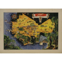
Original map poster by G. Carriat Rolant for AOF (Afrique Occidentale Française)
Located in PARIS, FR
The circa 1950 original map poster by G. Carriat Rolant for AOF (Afrique Occidentale Française) is a notable example of mid-20th-century cartographic art and colonial-era representation. Numbered 584 out of 1000, this limited-edition piece was edited by Paul Bory...
Category
1950s Prints and Multiples
Materials
Lithograph, Paper
Circa 1950 original illustrated map for "Carte France autour de Bordeaux"
Located in PARIS, FR
The circa 1950 original illustrated map for "Carte France autour de Bordeaux" is an excellent representation of mid-20th century cartography, focusing on the area surrounding Bordeau...
Category
1950s Prints and Multiples
Materials
Paper, Linen
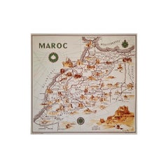
illustrated map of Morocco created in 1950 by Delaye
Located in PARIS, FR
Beautiful illustrated map of Morocco created in 1950 by Delaye. Main roads, car tracks, railroads are represented. This illustrated map is printed by P...
Category
1950s Prints and Multiples
Materials
Lithograph, Paper
You May Also Like
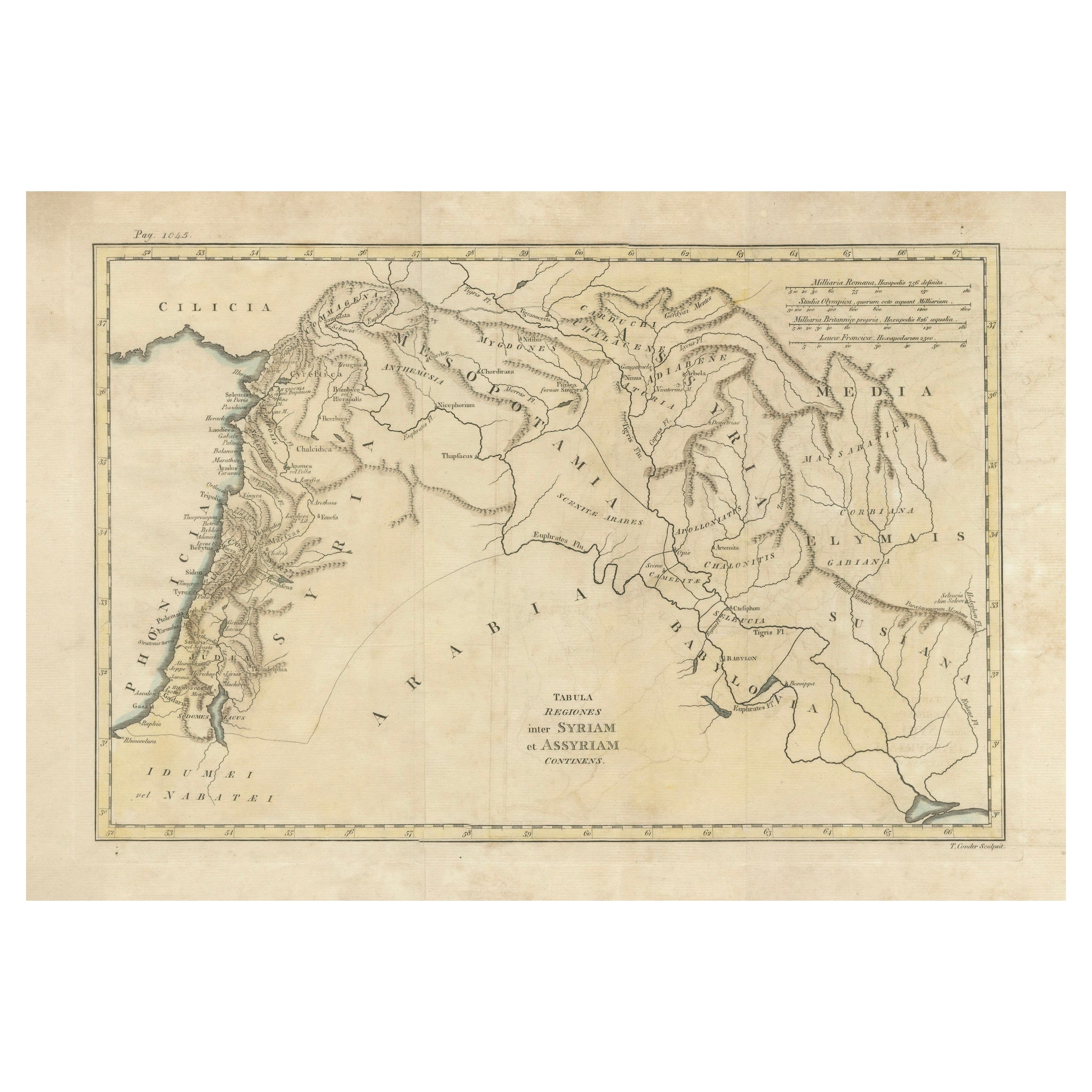
Antique 19th Century Map of Ancient Syria & Assyria - Historical Regions, c.1802
Located in Langweer, NL
19th Century Map of Ancient Syria and Assyria: 'Tabula Regiones inter Syriam et Assyriam continens'"*
This beautifully detailed 18th-century map, titled...
Category
Antique Early 1800s Maps
Materials
Paper
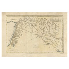
$298 Sale Price
20% Off
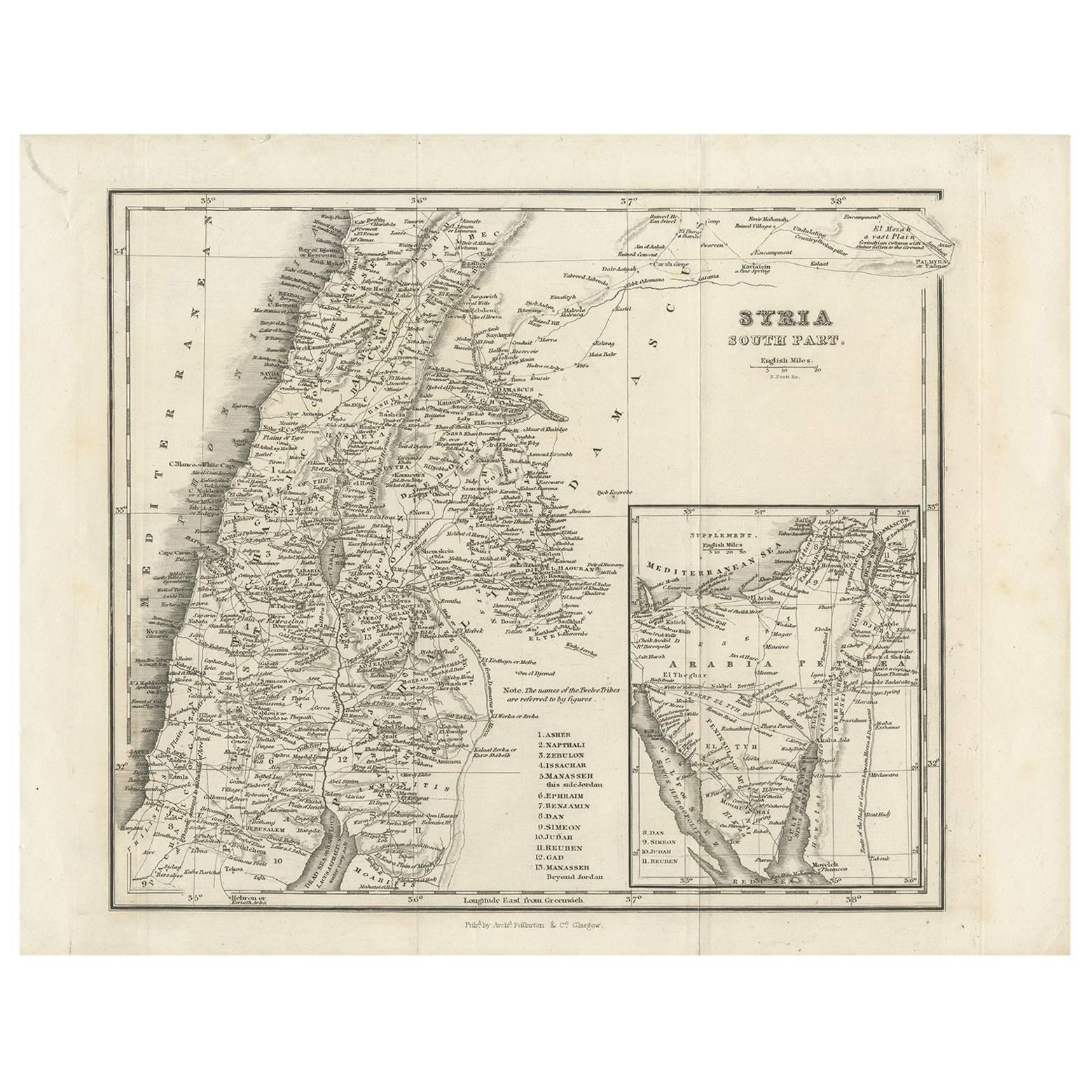
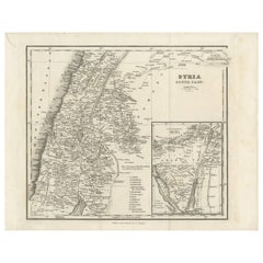
Antique Map of Southern Syria by Fullarton & Co, circa 1860
Located in Langweer, NL
Antique map titled 'Syria south part'. Published by Fullarton & Co, Glasgow, circa 1860.
- Title: Syria South Part
- Publisher: Fullarton & Co, Glasgow
- Date of Publication: Circa ...
Category
Antique Mid-19th Century English Maps
Materials
Paper
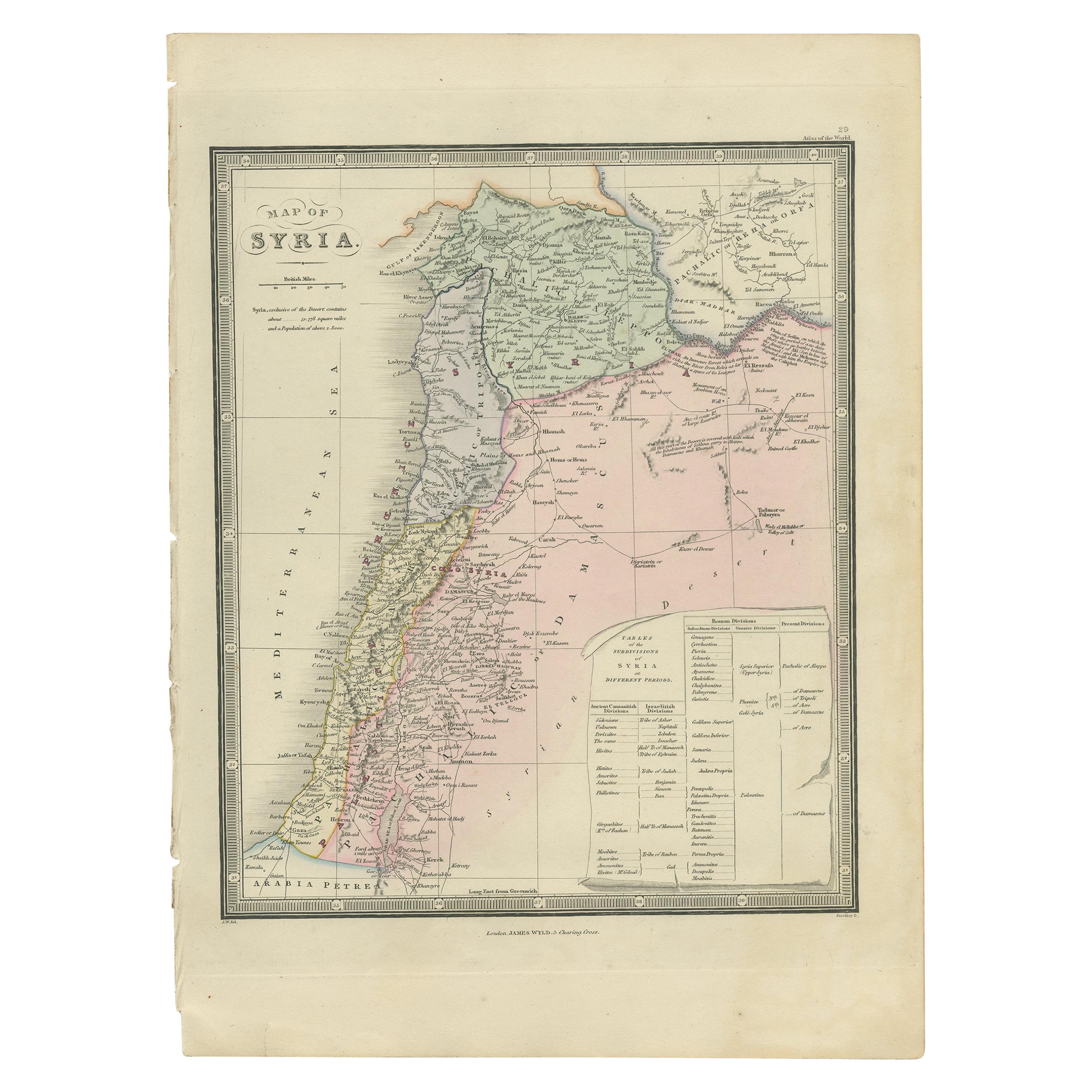
Antique Map of Syria by Wyld '1845'
Located in Langweer, NL
Antique map titled 'Map of Syria'. Original antique map of Syria. This map originates from 'An Atlas of the World, Comprehending Separate Maps of its
Var...
Category
Antique Mid-19th Century Maps
Materials
Paper

$240 Sale Price
20% Off
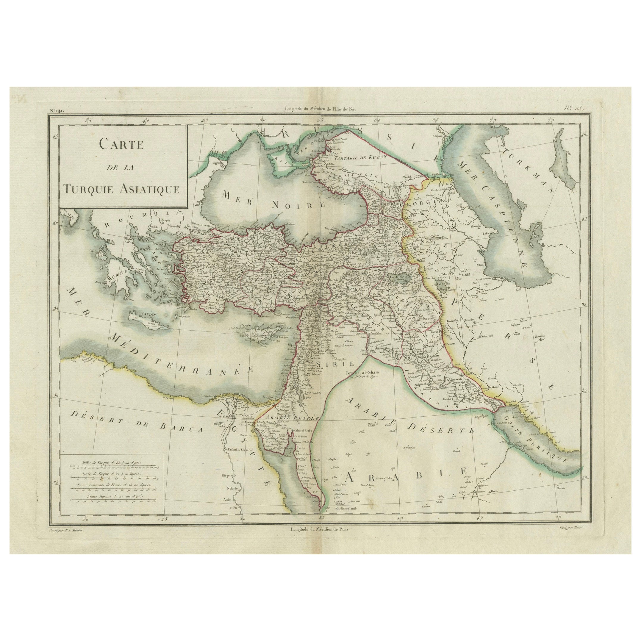
Antique Map of Asian Turkey, Levant, and Mesopotamia by Tardieu, circa 1802
Located in Langweer, NL
This is an original antique map titled "Carte de la Turquie Asiatique," depicting the Asian territories of the Ottoman Empire. Created by Pierre Antoine Tardieu, this map illustrates...
Category
Antique Early 1800s French Maps
Materials
Paper
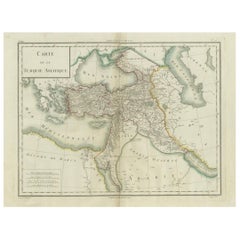
$423 Sale Price
20% Off
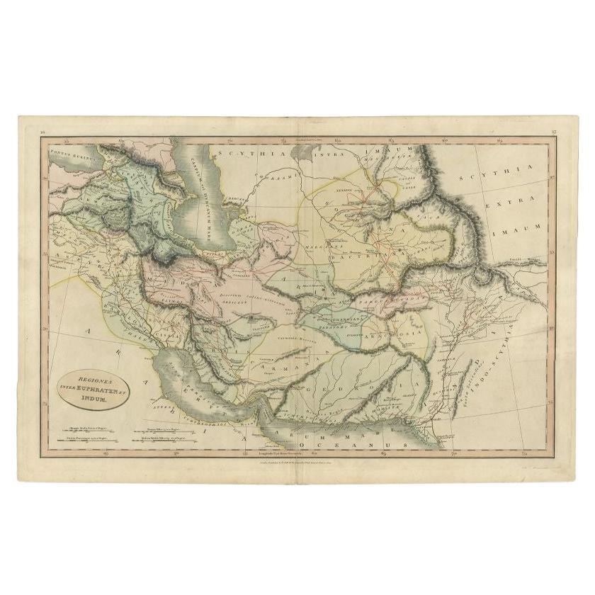
Antique Map of the Middle East by Smith, 1809
Located in Langweer, NL
Antique map titled 'Regiones inter Euphraten et Indum'. Old map of the Middle East showing the region between the Euphrates and Indus river. Ori...
Category
Antique 19th Century Maps
Materials
Paper
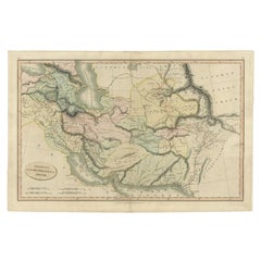
$130 Sale Price
20% Off
Turkey in Asia – Antique Ottoman Empire Map by John Tallis, ca. 1851
Located in Langweer, NL
Turkey in Asia – Antique Ottoman Empire Map by John Tallis, ca. 1851
This decorative 19th-century map titled "Turkey in Asia" was published by John Tallis & Company around 1851. Eng...
Category
Antique Mid-19th Century English Maps
Materials
Paper

More Ways To Browse
Circa 1825
Antique Syrian
Palestine Antique
Antique Map Of Middle East
Claude Le Lorrain
Colin Roberts
Colosseum Print
Communist Art
David Bomberg
David Lemon
Dorothea Rockburne
Edo Period Woodblock
Egon Schiele And Max Jaffe
Erotic 1920
Harriet Tubman
Helen Frankenthaler Lincoln Center Posters
Hercules Print
Homage To Andy Warhol