Items Similar to HOMANN, Johann Baptist (1663-1724) Nova Anglia. Septentrionali Americæ implantat

Want more images or videos?
Request additional images or videos from the seller
1 of 11
HOMANN, Johann BaptistHOMANN, Johann Baptist (1663-1724) Nova Anglia. Septentrionali Americæ implantat1740
1740
$3,500
£2,642.88
€3,046.98
CA$4,939.99
A$5,445.39
CHF 2,849.29
MX$66,813.26
NOK 35,866.90
SEK 33,541.22
DKK 22,744.83
About the Item
Map Sz: 18 3/4"H x 22 5/8"W
Frame Sz: 27 1/2"H x 31"W
Nuremberg: Homann Heirs, [circa 1740]. Copper-engraved map, with full original colour.
A highly fascinating and attractive map that showcases the curious nature of geographical knowledge of the American northeast, as considered by one of the greatest German cartographers.
This very fine map, in magnificent full original colour, focuses on New England, but embraces the entire territory from Philadelphia in the south up to the St. Lawrence Valley in the north. It depicts the region as it was considered before the British government commissioned advanced surveys of the subject. The geographic portrayal of the coast of New England is quite detailed, and features extensive hydrological information off of the coast. Curiously, however, Boston Harbor is shown to be dramatically larger than its actual appearance, and Cape Cod is shown to be an island. In the interior, Lake Champlain is depicted to be dramatically east of its true location, and New York's Lake Seneca is creatively shown to be a massive sea that drains into the Hudson Valley. To the north, the portrayal of New France is equally fanciful, as "Mont Royal" Island, the site of Montreal, takes on a massive, attenuated form immediately adjacent to Lake Ontario. True to Homann's artistic signature, the map features a finely-engraved cartouche in the lower right corner that depicts American scenes of commerce and nature. One of the most celebrated cartographers of his day, Johann Baptist Homann established the most successful German publishing house of the eighteenth century. His prolific business, which was inherited by his family after his death, dominated Germany's map market for over a century, and produced some of the finest maps and atlases of the age. He established himself in Nuremberg, and by 1715 was appointed Geographer to the Emperor. After Homann's death, the business was taken over by his son, Johann Christoph. From 1730, the firm was entrusted to committee of family members, the Homann Heirs, who published maps and atlases for the next two generations, maintaining the high standards set by Johann Baptist.
McCorkle, New England in Early Printed Maps, 724.1; Portinaro & Knirsch, The Cartography of North America, 116, Goss, The Mapping of North America, 50; Sellers & Van Ee, Maps & Charts of North America & West Indies, 807;.
- Creator:HOMANN, Johann Baptist
- Creation Year:1740
- Dimensions:Height: 27.5 in (69.85 cm)Width: 31 in (78.74 cm)
- Medium:
- Period:1740-1749
- Condition:
- Gallery Location:Bristol, CT
- Reference Number:Seller: 431591stDibs: LU1260113221842
About the Seller
4.8
Vetted Professional Seller
Every seller passes strict standards for authenticity and reliability
Established in 2000
1stDibs seller since 2019
131 sales on 1stDibs
Typical response time: <1 hour
- ShippingRetrieving quote...Shipping from: Bristol, CT
- Return Policy
Authenticity Guarantee
In the unlikely event there’s an issue with an item’s authenticity, contact us within 1 year for a full refund. DetailsMoney-Back Guarantee
If your item is not as described, is damaged in transit, or does not arrive, contact us within 7 days for a full refund. Details24-Hour Cancellation
You have a 24-hour grace period in which to reconsider your purchase, with no questions asked.Vetted Professional Sellers
Our world-class sellers must adhere to strict standards for service and quality, maintaining the integrity of our listings.Price-Match Guarantee
If you find that a seller listed the same item for a lower price elsewhere, we’ll match it.Trusted Global Delivery
Our best-in-class carrier network provides specialized shipping options worldwide, including custom delivery.More From This Seller
View AllAmerican Revolution Map Drawn For John Marshall's "Life Of Washington" First Acc
Located in Bristol, CT
A Map Of The Country Which Was The Scene Of Operations Of The Northern Army: Including The Wilderness Through Which Gerneral Arnold Marched To Attack Plate VI
Map Sz: 11"H x 9 1/4"W...
Category
Early 1800s Prints and Multiples
Materials
Paper, Engraving
Plan Of The Northern Part Of New Jersey Showing The Positions Of The American &
By Richard Phillips
Located in Bristol, CT
After Crossing The North River in 1776
Map Sz: 9 7/8"H x 7 1/4"W
Frame Sz: 18 5/8"H x 15 3/4"W
Engraved by J Yeagen
Uncolored map of Northern New Jersey, Staten Island and the lo...
Category
Early 1800s Prints and Multiples
Materials
Lithograph
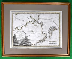
Le Coste Nord Ovest Dell' America E Nord Est Dell' Asia Delineate Sulle Ultime O
Located in Bristol, CT
Map Sz: 14 1/2"H x 19 7/8"W
Frame Sz: 21"H x 26 3/8"W
A fine example of Cassini's 1798 map of Alaska, the Bering Strait, and Siberia. Cassini issued this map in his 1798 atlas to illustrate the discoveries made by James Cook. Cook was the first to accurately chart the Alaskan coastline and provide a detailed mapping of the Aleutian Islands. Cook's zigzagging route is shown as he skirts the Aleutian Islands, passes through the Bering Strait into the Arctic Ocean, and then turns back to sail south along the Siberian Coast. Here the Aleutians are collectively identified as Isole Alessiane, though many of the original islands...
Category
1790s Prints and Multiples
Materials
Paper
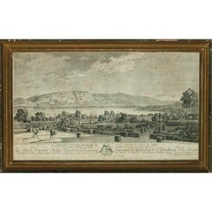
"Premiere Vue Des Environs Du Lac Leman Du Cote Du Midi" c1780
Located in Bristol, CT
Classic c1780 engraving of topiary gardens overlooking Geneve, Switz.
Provenance: a Newport, RI estate
Image Sz: 12 1/8"H x 20 7/8"W
Frame Sz: 16"H x 24"W
w/ gilt wood period frame
Category
1780s More Art
Materials
Engraving
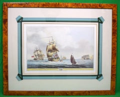
"A Frigate With A View Of The Needles" 1806 Print
Located in Bristol, CT
Print Sz: 11 5/8"H x 17"W
Frame Sz: 22 1/8"H x 27 3/8"W
1806
Dominic Serres RA (1722–1793), also known as Dominic Serres the Elder, was a French-born...
Category
Mid-19th Century Prints and Multiples
Materials
Paper
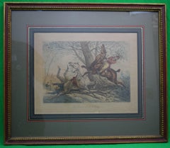
"Les Accidents De La Chasse" By Carle Vernet
By Carle Vernet (Antoine Charles Horace Vernet)
Located in Bristol, CT
Art Sz: 9 1/2"H x 12"W
Frame Sz: 16 1/2"H x 19"W
Custom framed by J. Pocker & Son
Antoine Charles Horace Vernet, better known as Carle Vernet (14 August 1758 – 17 November 1836), ...
Category
18th Century Prints and Multiples
Materials
Paper
You May Also Like
Rare Original Map of New Amsterdam (New York) – “Restitutio”, ca. 1674 –
Located in Dronten, NL
An exceptionally rare and original 17th-century engraving of New Amsterdam, now New York City, published by the renowned Amsterdam cartographer Carel (Carolus) Allard around 1674. Kn...
Category
Antique 17th Century Dutch Maps
Materials
Paper

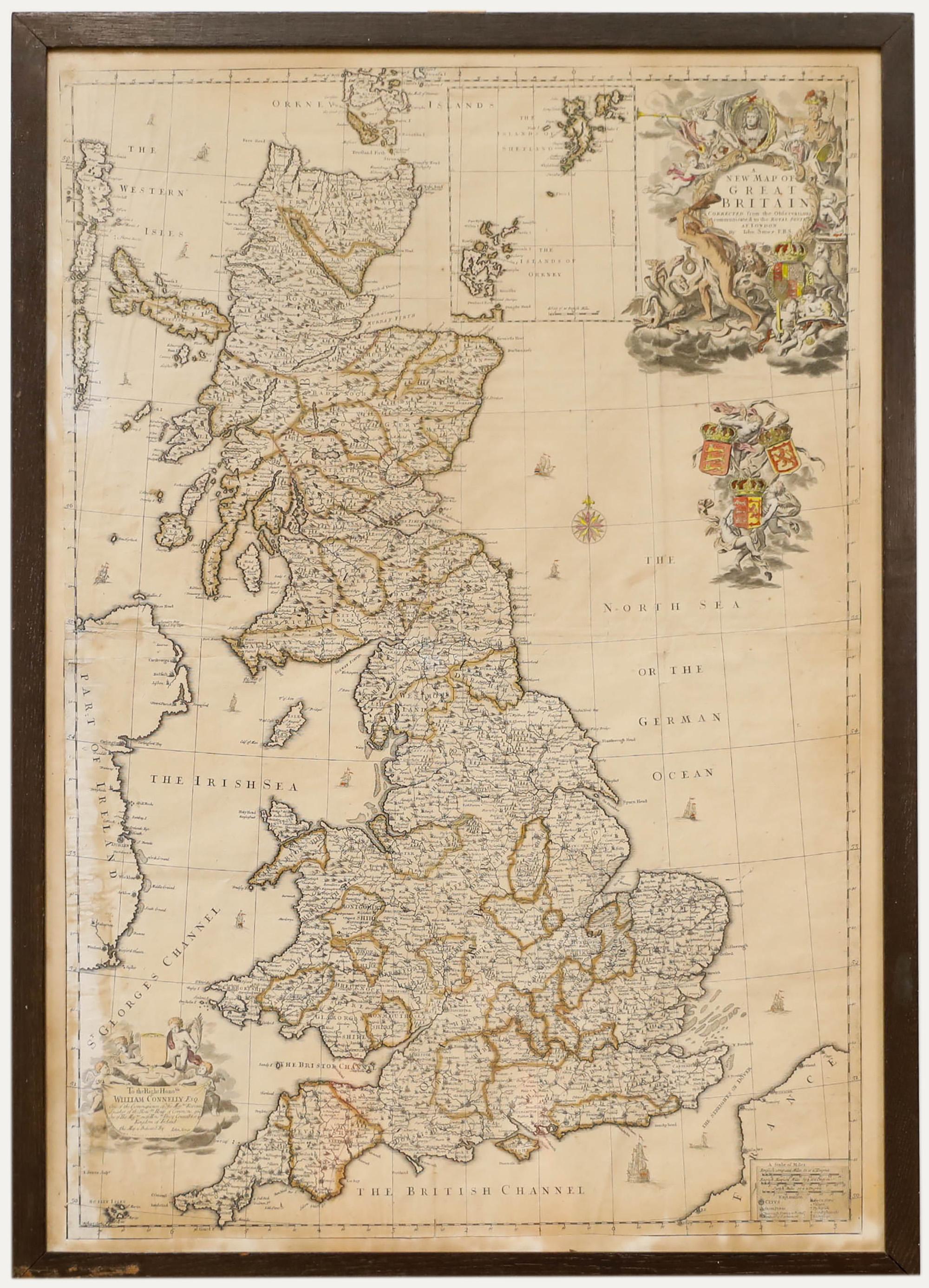
John Senex (1678-1740) - 18th Century Engraving, A New Map of Great Britain
By John Senex
Located in Corsham, GB
A New Map of Great Britain - Corrected from the Observations Communicated to the Royal Society at London. By John Senex F.R.S. A double-page engraved map on 2 sheets joined, with lat...
Category
18th Century More Prints
Materials
Engraving

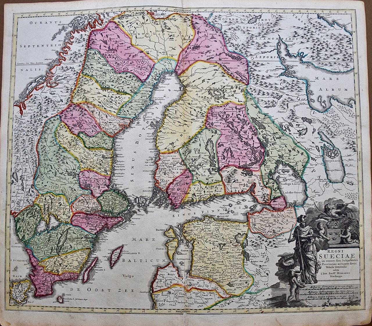
Sweden and Adjacent Portions of Scandinavia: A Hand-colored 18th C. Homann Map
By Johann Baptist Homann
Located in Alamo, CA
This hand-colored copper-plate map of Sweden and adjacent portions of Scandinavia entitled "Regni Sueciae in Omnes suas Subjacentes Provincias accurate divisi Tabula Generalis" was c...
Category
Early 18th Century Old Masters Landscape Prints
Materials
Engraving

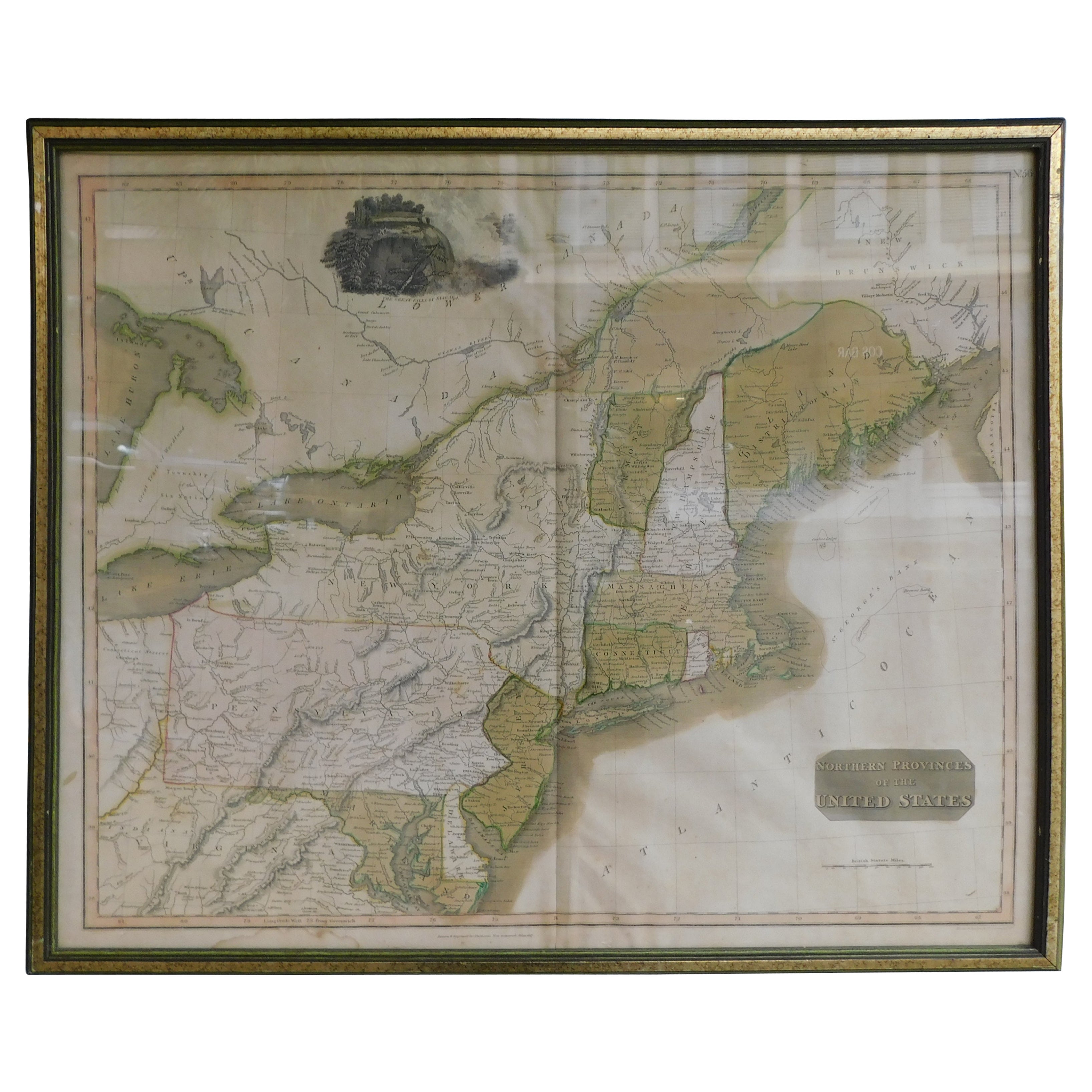
English Engraved Hand Colored Map of the North Eastern United States, circa 1817
Located in Charleston, SC
English copper engraved hand colored map of the North Eastern United States matted under glass in a gilt frame, Early 19th Century. Drawn and Engraved for Thomson's New General Atlas...
Category
Antique 1810s English George III Maps
Materials
Glass, Giltwood, Paint, Paper

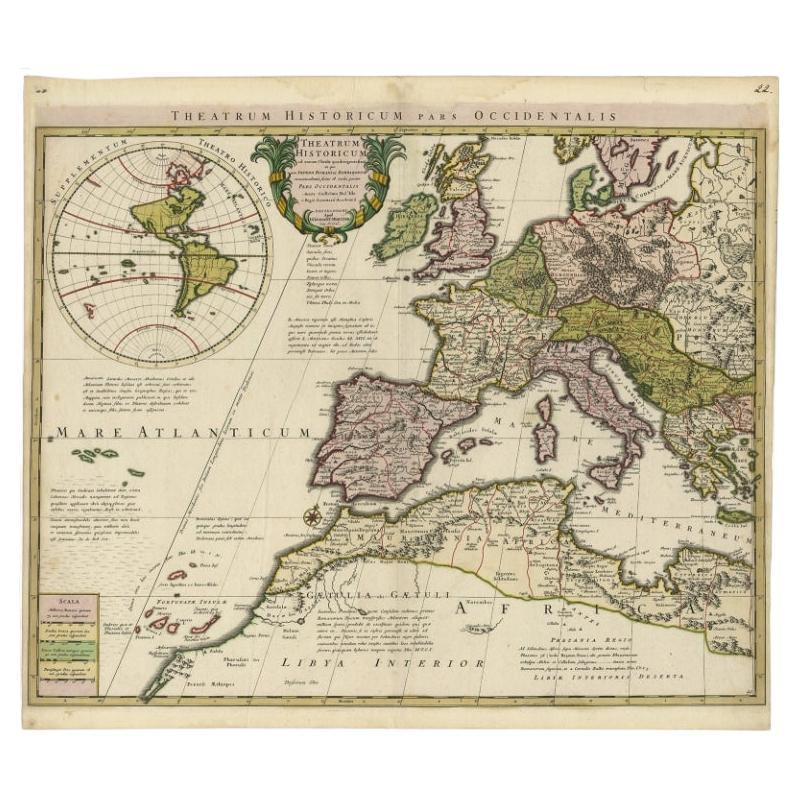
Finely Engraved Antique Map of Europe with inset of America, c.1745
By Guillaume De L'Isle
Located in Langweer, NL
Antique map titled 'Theatrum Historicum pars Occidentalis.' Finely engraved historical map with a profusion of details. It shows western Europe and the northern Mediterranean basin a...
Category
Antique 18th Century Maps
Materials
Paper
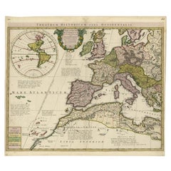
$1,386 Sale Price
20% Off
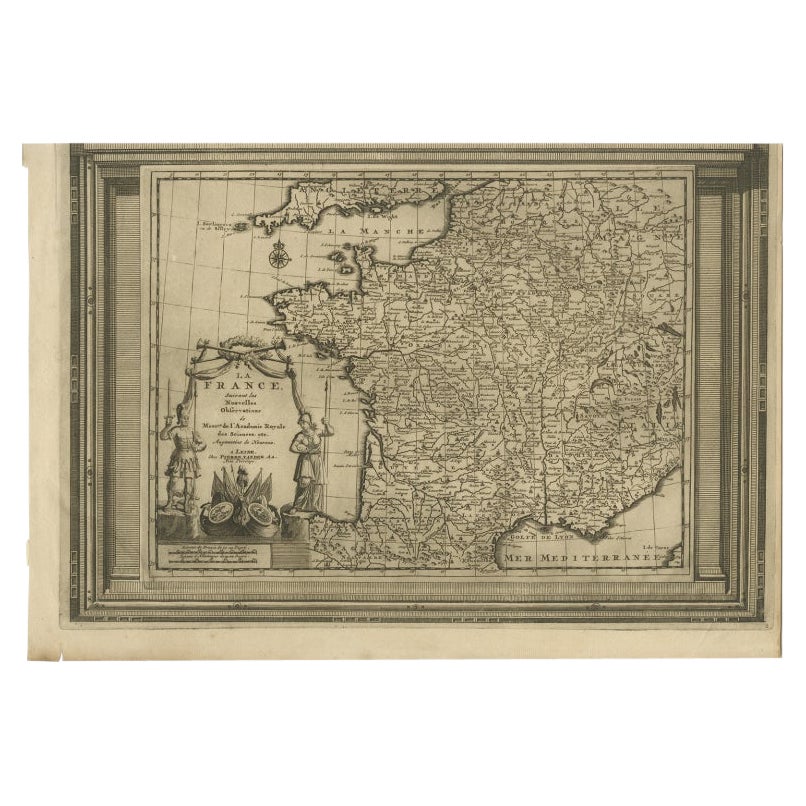
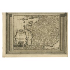
Antique Map of France with Beautiful Title Cartouche and Border, c.1740
Located in Langweer, NL
Antique map titled 'La France suivant les nouvelles Observations de Messrs de l'Academie Royale des Sciences etc.'. Rare map of France with beautiful title cartouche and decorative b...
Category
Antique 18th Century Maps
Materials
Paper
$430 Sale Price
20% Off
More Ways To Browse
Antique Maps Of North America
Antique Maps West Indies
Antique Mushroom Prints
Dessin Picasso
French Riviera Poster
Grace Jones Fashion
Harpers Poster
Intaglio Bird
Jacques Durand
Jean Cocteau Orpheus
John Kennedy Sculpture
Leon Bakst
Lithograph Four Seasons
Marilyn Monroe Lithograph
Mid Century Modern Winter Scene
Picasso Tetes
Vintage Ice Skater
Vintage Rochas