IMPORTANT MAP OF THE N.W. PASSAGE, CALIFORNIA, ASIA - Am. Revolutionary War Time
View Similar Items


Want more images or videos?
Request additional images or videos from the seller
1 of 12
Antonio ZattaIMPORTANT MAP OF THE N.W. PASSAGE, CALIFORNIA, ASIA - Am. Revolutionary War Time1776
1776
About the Item
- Creator:Antonio Zatta (1757 - 1797)
- Creation Year:1776
- Dimensions:Height: 12.5 in (31.75 cm)Width: 16.125 in (40.96 cm)
- Medium:
- Movement & Style:
- Period:1770-1779
- Condition:
- Gallery Location:Santa Monica, CA
- Reference Number:1stDibs: LU411310454332
About the Seller
5.0
Recognized Seller
These prestigious sellers are industry leaders and represent the highest echelon for item quality and design.
Gold Seller
Premium sellers maintaining a 4.3+ rating and 24-hour response times
Established in 1977
1stDibs seller since 2016
286 sales on 1stDibs
Typical response time: 2 hours
Associations
International Fine Print Dealers Association
Authenticity Guarantee
In the unlikely event there’s an issue with an item’s authenticity, contact us within 1 year for a full refund. DetailsMoney-Back Guarantee
If your item is not as described, is damaged in transit, or does not arrive, contact us within 7 days for a full refund. Details24-Hour Cancellation
You have a 24-hour grace period in which to reconsider your purchase, with no questions asked.Vetted Professional Sellers
Our world-class sellers must adhere to strict standards for service and quality, maintaining the integrity of our listings.Price-Match Guarantee
If you find that a seller listed the same item for a lower price elsewhere, we’ll match it.Trusted Global Delivery
Our best-in-class carrier network provides specialized shipping options worldwide, including custom delivery.More From This Seller
View AllWORLD MAP - Planisphaerium Terrestre Sive Terrarum Orbis... 1696
By Carel Allard
Located in Santa Monica, CA
CAREL ALLARD (1648 – 1709)
PLANISPHAERIUM TERRESTRE SIVE TERRARUM ORBIS… 1696 (Shirley 578)
Engraving, 20 ½ x 23 ½”, sheet 21 x 24 1/8". A stunning double hemisphere World Map...
Category
17th Century Old Masters Landscape Prints
Materials
Engraving

New Map of the Terraqueous Globe - WORLD MAP - CALIFORNIA AS AN ISLAND
By Edward Wells
Located in Santa Monica, CA
EDWARD WELLS (British 1667- 1727)
A NEW MAP of the TERRAQUEOUS GLOBE - according to the latest Discoveries and most general Divisions of it into CONTINENTS and OCEANS, 1700-01 (Shirley 609)
Engraved by Michael Burghers, Oxford. Hand-colored, Platemark 14 1/4 x 20 1/8 inches. Central cartouche flanked by figures representing the continents with dedication to William, Duke of Gloucester...
Category
Early 1700s Old Masters Landscape Prints
Materials
Engraving

PERU
By Johannes Jansson
Located in Santa Monica, CA
JOHANNES JANSSON (1588 - 1664)
PERU, engraving with early coloring. Platemark 15 1/8 x 19 3/8 inches, sheet 17 x 20 1/2
A nice example of one of the earliest maps of Peru. From the ...
Category
1630s Old Masters Landscape Prints
Materials
Engraving

AMERICAE - Sive Novi Orbis, Nova Descriptio
By Abraham Ortelius
Located in Santa Monica, CA
ABRAHAM ORTELIUS (1527 - 1598)
AMERICAE SIVE NOVI ORBIS, NOVA DESCRIPTIO, 1587 (1603) (Van Den Broecke 11, Burden 64; Schwartz & Ehrenberg 69)
Engraving. A very good, well printed...
Category
16th Century Old Masters Landscape Prints
Materials
Engraving

AMERICA
By John Speed
Located in Santa Monica, CA
IMPORTANT AMERICAN MAP - ONE OF THE FIRST TO SHOW CALIFORNIA as an ISLAND
JOHN SPEED (1552-1629)
AMERICA - With Those Known Parts In That Unknown Worlde (sic),
1626-(76)
(Burden 217 iv/iv) Engraving, uncolored. Engraved by Abraham Goos and
published by Thomas Basset and Richard Chiswell - 4th state of 4 in 1676
15 1/8 x 20 1/2” From “A Prospect of the Most Famous Parts of the
World”. Generally good condition. A repaired split in lower centerfold. This
is the most common version of this important map...
Category
1620s Old Masters Landscape Prints
Materials
Engraving

$4,000 Sale Price
52% Off
The Deluge - JOSEPH MALLORD WILLIAM TURNER (1775 - 1851)
By Joseph Mallord William Turner
Located in Santa Monica, CA
(after) JOSEPH MALLORD WILLIAM TURNER (1775 - 1851)
THE DELUGE, 1828. Mezzotint, Engraved by I. P. Quilly after a painting by J. M.W. Turner R.A.. Image ...
Category
1820s Old Masters Landscape Prints
Materials
Mezzotint

$3,200 Sale Price
20% Off
You May Also Like
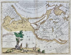
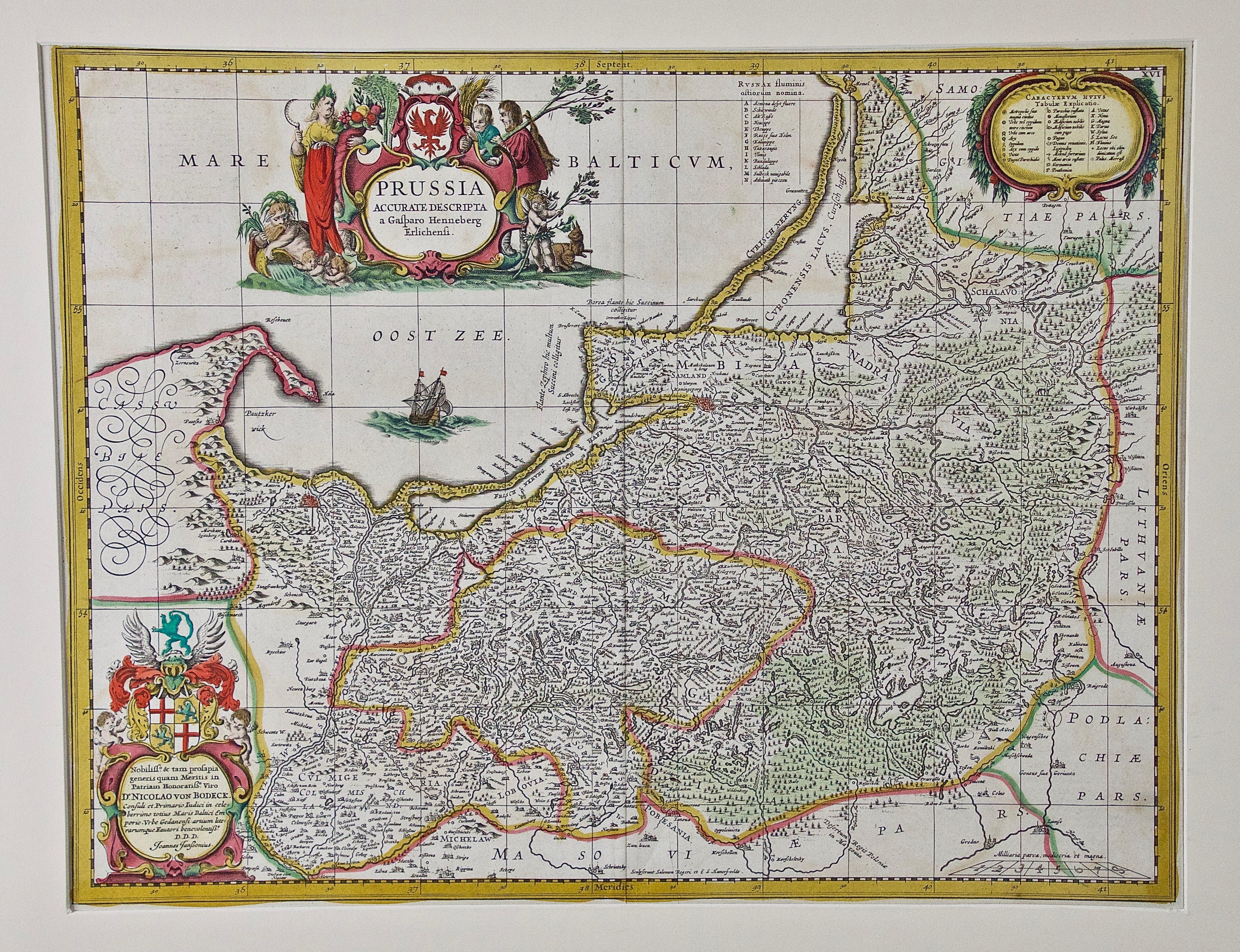
Danube River, Italy, Greece and Croatia: A Hand-colored 18th C. Homann Map
By Johann Baptist Homann
Located in Alamo, CA
"Fluviorum in Europa principis Danubii" is a hand-colored map of the region about the Danube river created by Johann Baptist Homann (1663-1724) in his 'Atlas Novus Terrarum', publish...
Category
Early 18th Century Old Masters Landscape Prints
Materials
Engraving

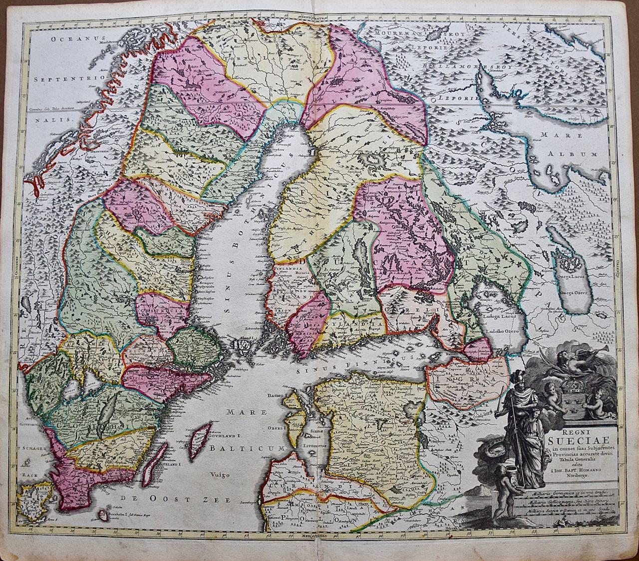
Sweden and Adjacent Portions of Scandinavia: A Hand-colored 18th C. Homann Map
By Johann Baptist Homann
Located in Alamo, CA
This hand-colored copper-plate map of Sweden and adjacent portions of Scandinavia entitled "Regni Sueciae in Omnes suas Subjacentes Provincias accurate divisi Tabula Generalis" was c...
Category
Early 18th Century Old Masters Landscape Prints
Materials
Engraving

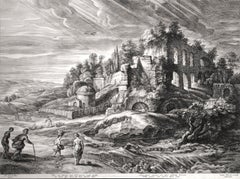
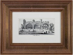
17th century engraving black and white landscape ancient building scene
By Israel Silvestre
Located in Milwaukee, WI
"Tempio Della Pace" is an original engraving by Israel Silvestre. The title is printed below the miniature image. It shows a frontal view of the remains of the Temple of Peace in Rom...
Category
1650s Old Masters Landscape Prints
Materials
Paper, Ink, Engraving
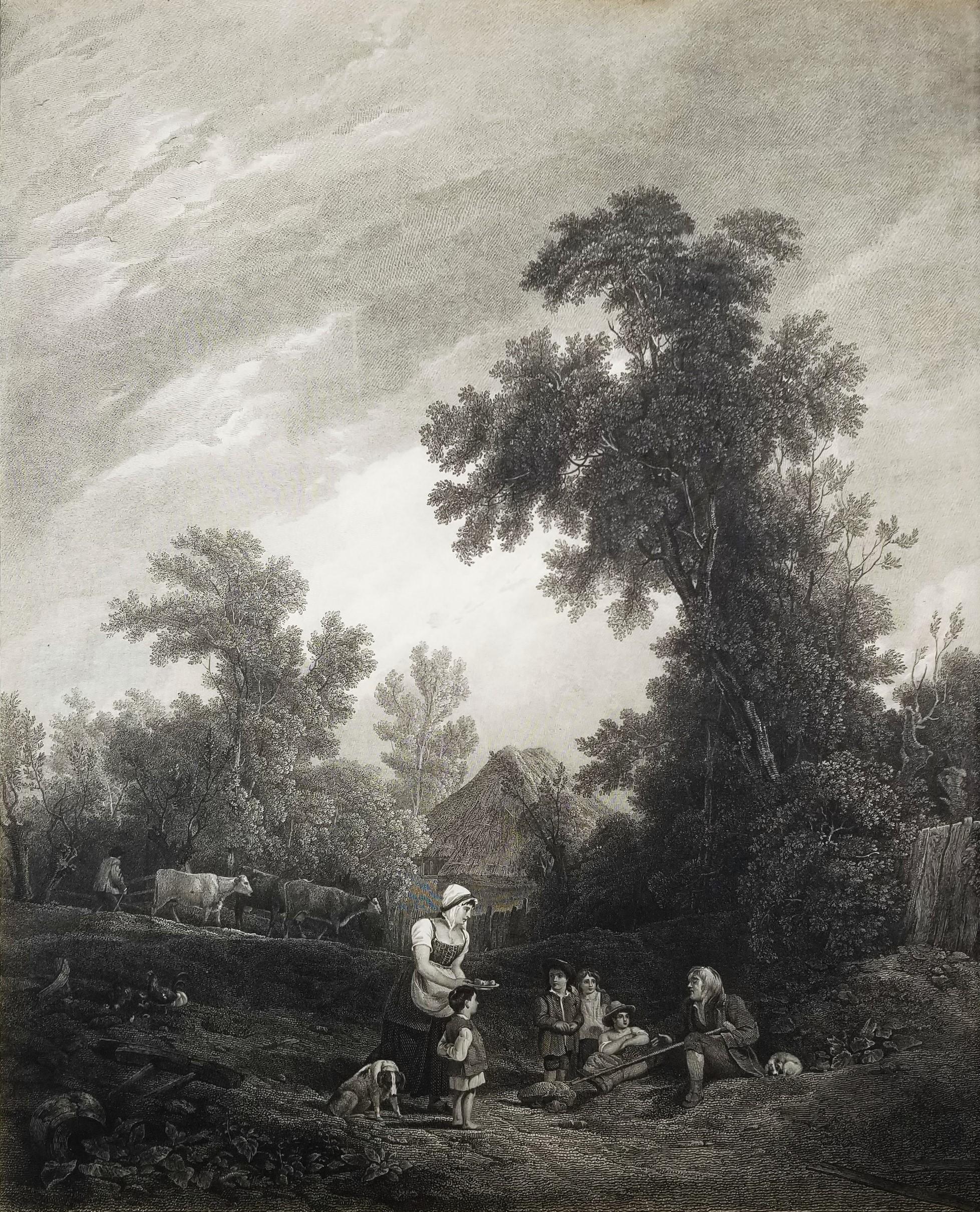
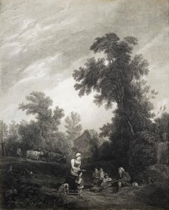
Benevolent Cottagers /// English Landscape Figurative Village Scene Engraving
Located in Saint Augustine, FL
Artist: (after) Sir Augustus Wall Callcott (English, 1779-1844)
Title: "Benevolent Cottagers"
Year: 1816
Medium: Original Etching and Engraving on laid paper
Limited edition: Unknown...
Category
1810s Old Masters Landscape Prints
Materials
Engraving, Etching, Laid Paper, Intaglio
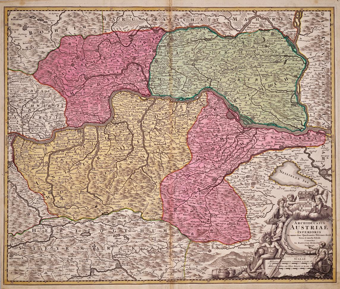
Hand Colored 18th Century Homann Map of Austria Including Vienna & the Danube
By Johann Baptist Homann
Located in Alamo, CA
"Archiducatus Austriae inferioris" is a hand colored map of Austria created by Johann Baptist Homann (1663-1724) and published in Nuremberg, Germany in 1728 shortly after his death. ...
Category
Early 18th Century Old Masters Landscape Prints
Materials
Engraving

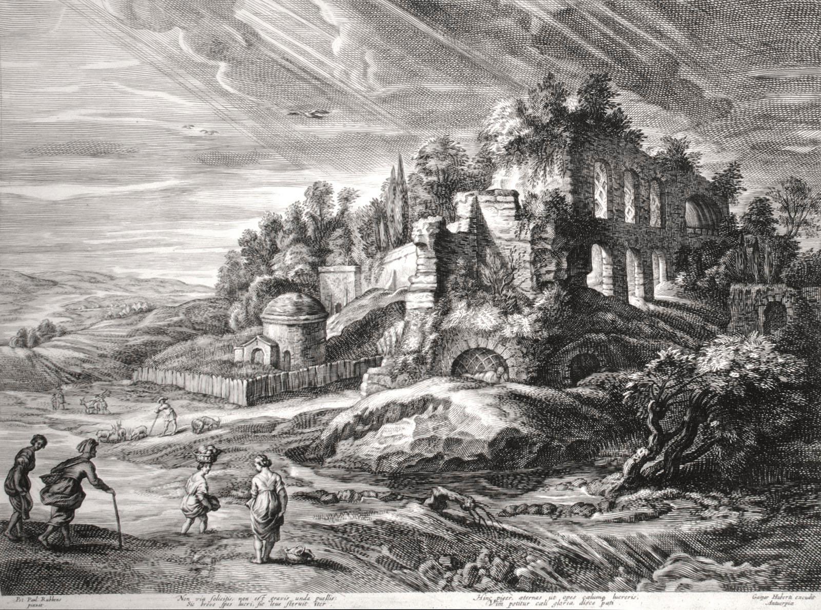
Landscape with Roman Ruins
By (After) Peter Paul Rubens
Located in Chicago, IL
Engraving after Peter Paul Rubens (Siegen 1577 - 1640 Antwerp), executed by Schelte Adams Bolswert (Bolsward c. 1586 -1659 Antwerp).
Bolswert was one of the major printmakers in the ...
Category
17th Century Old Masters Landscape Prints
Materials
Engraving