Items Similar to Ostiakes


Want more images or videos?
Request additional images or videos from the seller
1 of 4
Cornelis de BruijnOstiakes1718
1718
$300
£227.31
€260.82
CA$422.15
A$464.06
CHF 243.89
MX$5,635.35
NOK 3,042.43
SEK 2,882.49
DKK 1,946.54
About the Item
Ostiakes
Engraving, 1718
From: Voyages de Corneille le Brun par la Moscovie, en Perse, et aux Indes Occidentales (French translation, 1718), Chapter XXI
The Ostyak are a member of any of a group of nomadic peoples of western Siberia. The correct spelling is Ostiakes, which refers to an Asian people from Siberia who settled near the Ob River.
The term "Ostyak" was previously used to refer to the Khanty and Ket peoples of Siberia, Russia, as well as the Selkup people, who were called Ostyak-Samoyed.
Condition: Excellent
Image size: 5 3/4 x 6 1/2 inches
Biography
De Bruijn was born in The Hague .
During his first tour, he visited Rome, where he became a member of the Bentvueghels with the nickname Adonis , which is how he signed the bentbrief of Abraham Genoels II . He traveled to Egypt and climbed to the top of a pyramid where he left his signature. De Bruijn made secret drawings of Jerusalem, then part of the Ottoman Empire . His drawings of Palmyra are copies. De Bruijn reached Cyprus and stayed among the Dutch merchants in Smyrna and Constantinople . From 1684 he worked in Venice with the painter Johann Carl Loth , returning in 1693 to The Hague, where he sold his souvenirs. In 1698 he published his book with drawings, which was a success and was translated into several languages. Two examples have colored illustrations, the first color prints in history. Among his drawings were the first pictures of the interior of the Great Pyramid and Jerusalem that became known in Europe.
In 1701 he headed for Archangelsk . During his second tour he visited the Samoyeds in northern Russia. In Moscow he became acquainted with emperor Peter the Great : de Bruijn painted his nieces, and the paintings were sent to possible candidates for marriage.
In late April 1703, De Bruijn left Moscow along with the party of an Armenian merchants from Isfahan whose name he recorded as Jacob Daviedof. De Bruijn and the Armenians sailed down the Moscow River , the Oka and the Volga , eventually reaching Astrakhan . Thanks to de Bruijn's short stopover in Nizhny Novgorod during the Easter holidays, we now have his description of that major center of the Russian Volga trade as it existed in 1703, with its Kremlin , stone churches, and a lively bar ( kabak ) scene.
Leaving the borders of the Russian state, de Bruijn arrived to Persia, where he made drawings of towns like Isfahan and Persepolis (1704–1705). He continued to Java and returned to Persia, Russia, and ultimately the Netherlands.
His drawings of Persepolis , a city destroyed by Alexander the Great , caused a sensation. The mayor of Amsterdam Nicolaes Witsen and a member of the Royal Society probably asked him to draw the city famous for its 40 columns. For a century, they were the best prints available to western scholars. De Bruijn was accused of plagiarism and his second book, Reizen over Moskovie was not such a success. From Amsterdam he fled to Vianen . De Bruijn was invited by a Mennonite silk merchant and died in Utrecht . It is not known when and where he was buried.
De Bruijn, who had read every Greek and Latin source he had been able to obtain, displays a convincing knowledge of subjects, at times going into the humorous. In Persia, he obtained a copy of Firdausi 's Shahnamê , which he summarized and made accessible to the west.
- Creator:Cornelis de Bruijn
- Creation Year:1718
- Dimensions:Height: 5.75 in (14.61 cm)Width: 6.5 in (16.51 cm)
- Medium:
- Movement & Style:
- Period:1710-1719
- Condition:
- Gallery Location:Fairlawn, OH
- Reference Number:Seller: FA95511stDibs: LU14015513552
About the Seller
5.0
Recognized Seller
These prestigious sellers are industry leaders and represent the highest echelon for item quality and design.
Platinum Seller
Premium sellers with a 4.7+ rating and 24-hour response times
Established in 1978
1stDibs seller since 2013
813 sales on 1stDibs
Typical response time: <1 hour
Associations
International Fine Print Dealers Association
- ShippingRetrieving quote...Shipping from: Akron, OH
- Return Policy
Authenticity Guarantee
In the unlikely event there’s an issue with an item’s authenticity, contact us within 1 year for a full refund. DetailsMoney-Back Guarantee
If your item is not as described, is damaged in transit, or does not arrive, contact us within 7 days for a full refund. Details24-Hour Cancellation
You have a 24-hour grace period in which to reconsider your purchase, with no questions asked.Vetted Professional Sellers
Our world-class sellers must adhere to strict standards for service and quality, maintaining the integrity of our listings.Price-Match Guarantee
If you find that a seller listed the same item for a lower price elsewhere, we’ll match it.Trusted Global Delivery
Our best-in-class carrier network provides specialized shipping options worldwide, including custom delivery.More From This Seller
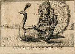
View AllEurito Echione e Etalide Argonote
Located in Fairlawn, OH
Eurito Echione e Etalide Argonote
Etching, 1664
after Remigio Cantagallina
From: La manifique carousel fait sur le fleuve de l"Arne a Florence, pour le Mariage du Grand Duc, (18 plates, this no. 14)
Depicts Three Argonauts conveyed on aquatic peacock
Published by Pierre Giffart, Paris
Note: This image is a record of the celebration on the Arno River in Florence of the marriage of Cosimo II de Medici and Maria Madaglena of Austria, 1608
Condition: Trimmed to the border line of the image
Slight foxing and staining to the sheet
Tipped on an "English Mount"
Image size: 3 9/16 x 4 15/16 inches
Reference: Bartsch XX.63.37 (copy after)
Drugulin 1179
Balthasar Moncornet
printmaker; publisher/printer
Tapissier, engraver and print publisher in Paris, specialist in ornament prints...
Category
1660s Old Masters Animal Prints
Materials
Etching
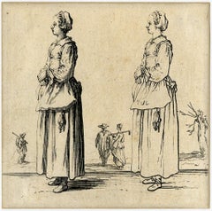
La Paysanne Tournee a Gauche, Les Mains Appuyees L’Une sue L’Autre
By Jacques Callot
Located in Fairlawn, OH
La Paysanne Tournee a Gauche, Les Mains Appuyees L’Une sue L’Autre (Peasant turned left holding her hands)
Etching, 1618
From: Varie Figure (16 plates)
Condition: very good, aging
Im...
Category
1610s Old Masters Figurative Prints
Materials
Etching
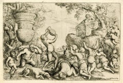
Bacchanal
By Giovanni Andrea Podestà
Located in Fairlawn, OH
Bacchanal
Etching, 1649
Inscribed in the square left: "Magnificentis/simo Principi/Paolo lorda/no. II Bracci/ani Duci/Aud. P.DDD/1640; Inscribed on right: Rome apud Franciscsum Saluucium
Condition: Usual centerfolds from paper manufacture
Plate: 10 3/8 x 15 1/2"
Sheet: 11 1/2 x 16 1/2";
References:
Bartsch XX.4
Sopher Plate 145
An impression of this image is in the collections of the Philadelphia Museum of Art and the National Gallery of Art, Washington
An exceptionally rich impression in excellent condition.
From Wikipedia, the free encyclopedia
Putti as Allegory of Music
Giovanni Andrea Podestà or Giovanni Andrea Podesta (1608 - c. 1674) was an Italian painter and engraver who was principally active in Rome. His principal subject matter is children playing in landscapes with classical objects. His works show the influence of Poussin's Arcadian landscapes and bacchanals, which were ultimately derived from Titian's bacchanals.
Life
Giovanni Andrea Podestà was born in Genoa. He was formed in Genoa with Giovanni Andrea de Ferrari and Domenico Fiasella according to the information provided by the contemporary Genoese biographer Raffaele Soprani. He is also recorded as an apprentice of Giovanni Battista Paggi in 1627.
His presence is documented from in 1634 in Rome where he made drawings after the statues and ancient reliefs at the famous Giustiniani collection. These were subsequently engraved for publication in the 'Galleria Giustiniani'. The artist's career ran a course similar to that of the young Domenico Fiasella. In Rome his art evolved in contact with the works of Poussin, Andrea di Leone, Pietro Testa...
Category
17th Century Old Masters Figurative Prints
Materials
Etching
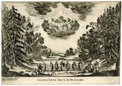
Scene II, Le Nozze Degli Dei
By Stefano Della Bella
Located in Fairlawn, OH
Scene II, Le Nozze Degli Dei
Etching, 1637
Signed in the plate lower left
The scene depicts the initial moment when Diana is revealed, surrounded by her nymphs, celebrating a success...
Category
1630s Old Masters Landscape Prints
Materials
Etching
Napoleon a Bautzen
By Hippolyte Bellangé
Located in Fairlawn, OH
Napoleon a Bautzen
Lithograph, 1822
Signed in the stone (see photo)
From: Arnault, A. V.
Vie Politique et Militaire de Napoleon (120 plates)
Published, Paris, Librairie Historiquem 1...
Category
1820s Romantic Figurative Prints
Materials
Lithograph

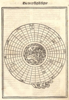
Father Stefan Fridolin, "Schatzbehalter" (Treasury of the True Riches
Located in Fairlawn, OH
Father Stefan Fridolin, "Schatzbehalter" (Treasury of the True Riches of Salvation): The 30th Figure - Astrological Diagram with Scene of the Nativity
Woodcut, 1491
Unsigned, as issued
Published by Anton Koberger
Diagram has Zodiac signs on outer ring, planets in the lower registers, and Nativity in the center.
Condition: Very good for a 15h century woodcut, with the usual slight age stains
Sheet size: 11 1/2 x 8 1/4 inches
Wogelmut was the teacher of Albrecht Durer and employed young Durer in many project of the last decade of the 15th century.
Michel Wolgemut Biography
Wolgemut trained with his father Valentin Wolgemut (who died in 1469 or 1470) and is thought to have been an assistant to Hans Pleydenwurff in Nuremberg. He worked with Gabriel Malesskircher in Munich early in 1471, leaving the city after unsuccessfully suing Malesskircher's daughter for breach of contract, claiming she had broken off their engagement. He then returned to his late father's workshop in Nuremberg, which his mother had maintained since Valentin's death.
In 1472 he married Pleydenwurff's widow and took over his workshop;[3] her son Wilhelm Pleydenwurff worked as an assistant, and from 1491 a partner, to Wolgemut. Some consider Wilhelm a finer artist than Wolgemut, however he died in January 1494, when he was probably still in his thirties. Wilhelm's oeuvre remains unclear, though works in various media have been attributed to him.
Woodcuts
Michael Wolgemut, Danse Macabre, 1493
Two large and copiously illustrated books have woodcuts supplied by Wolgemut and his stepson Wilhelm Pleydenwurff; both were printed and published by Germany's largest publisher, the Nuremberger Anton Koberger, who was also Dürer's godfather. The first is the Schatzbehalter der wahren Reichthumer des Heils (1491); the other is the Historia mundi, by Schedel (1493), usually known as the Nuremberg Chronicle...
Category
15th Century and Earlier Old Masters Figurative Prints
Materials
Woodcut
You May Also Like
The Quacksalver
By Adriaen van Ostade
Located in Middletown, NY
Etching on cream laid paper. 1/4 inch to 1/2 inch margins. In good condition with a band of minor discoloration along top and bottom sheet edge verso. One circular 1.5 inch- sized ar...
Category
Mid-17th Century Old Masters Figurative Prints
Materials
Laid Paper, Etching
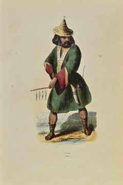
Ainos - Lithograph by Auguste Wahlen - 1844
Located in Roma, IT
Ainos is a lithograph made by Auguste Wahlen in 1844.
Hand colored.
Good condition.
At the center of the artwork is the original title "Ainos".
The work is part of Suite Moeurs, ...
Category
1840s Modern Figurative Prints
Materials
Lithograph
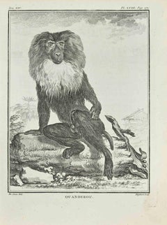
Ouanderou - Etching by A-J De Fehrt - 1771
Located in Roma, IT
Ouanderou is an etching realized in 1771 by A-J De Fehrt.
Signed in plate.
The artwork Belongs to the suite "Histoire naturelle, générale et particulière avec la description du Ca...
Category
1770s Modern Figurative Prints
Materials
Etching
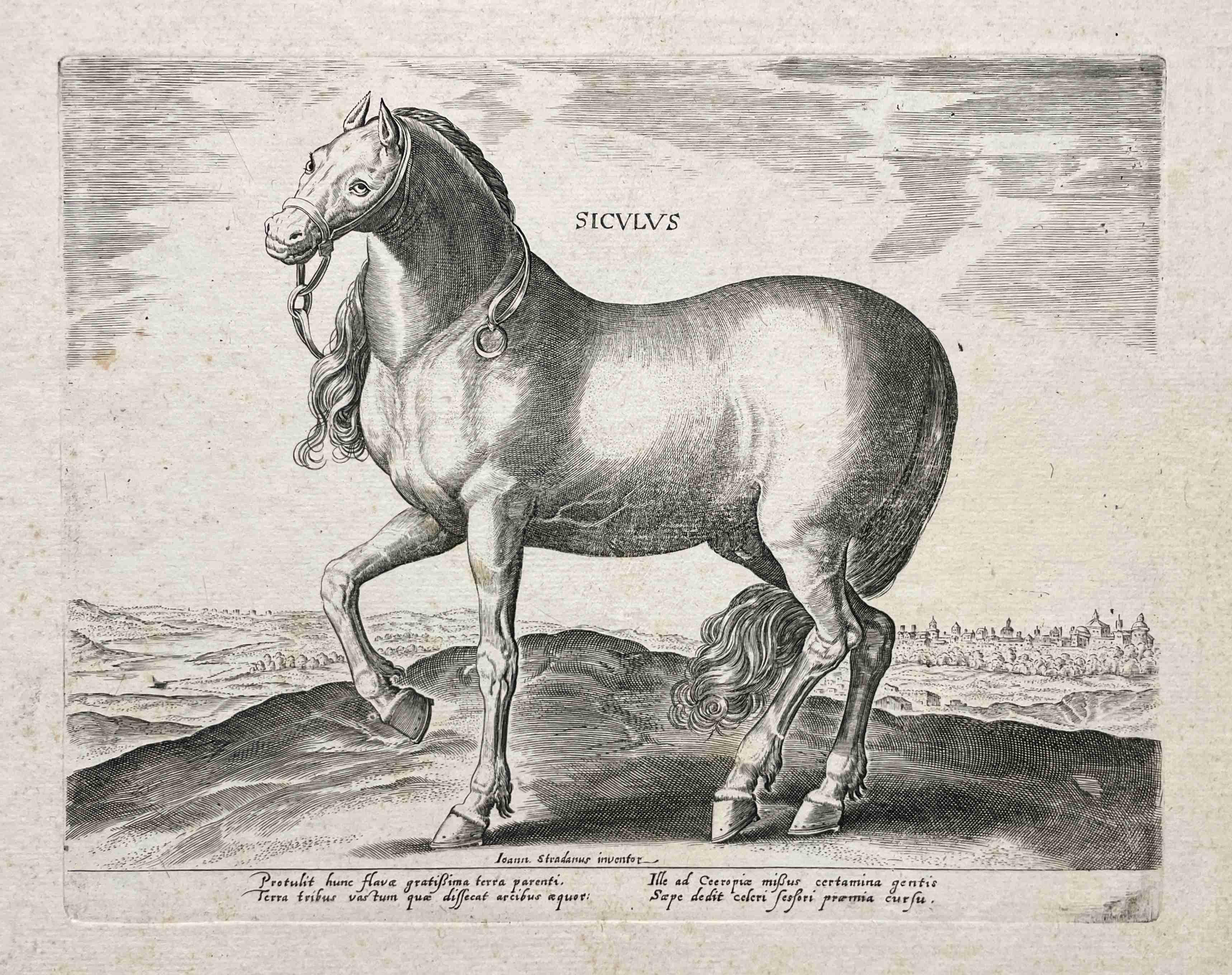
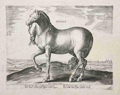
Ca. 1578 Old Master Engraving "Siculus" After Jan vander Straet (Strandanus)
By Jan Van der Straet
Located in Chicago, IL
Ca. 1578, Engraving "Siculus" - from the portfolio “The Stables of Don John of Austria” (Equile Austriaci Caroli V)" After Jan van der Straet (Stradanus).
An Old Master print from the series of 43 engravings depicting horses of different breeds from the stables of John of Austria (1547-1578), son of Emperor Charles V. Each print shows a horse in the foreground on a hilltop overlooking a distant landscape. Each bears it's title breed, centered upper edge, with two columns of brief explanatory Latin texts in the lower margins. Published by Philips Galle...
Category
16th Century Old Masters Animal Prints
Materials
Engraving, Paper
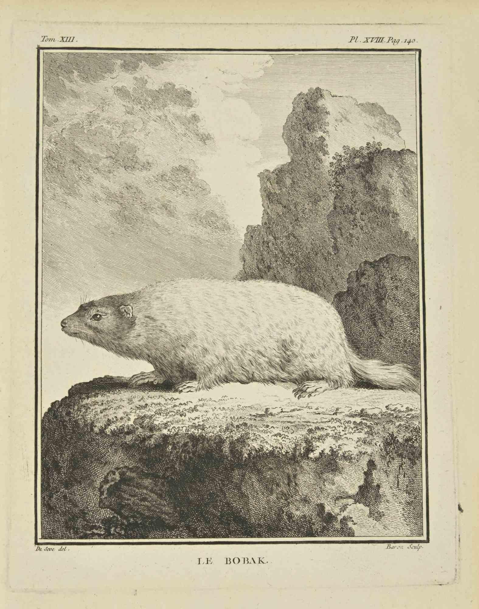
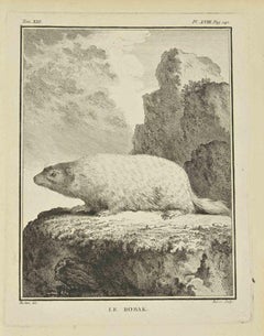
Le Bobak - Etching by Bernard Baron - 1771
Located in Roma, IT
Le Bobak is an etching realized in 1771 by Bernard Baron.
Signed in plate.
The artwork Belongs to the suite "Histoire naturelle, générale et particulière avec la description du Cab...
Category
18th Century Modern Figurative Prints
Materials
Etching
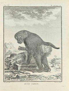
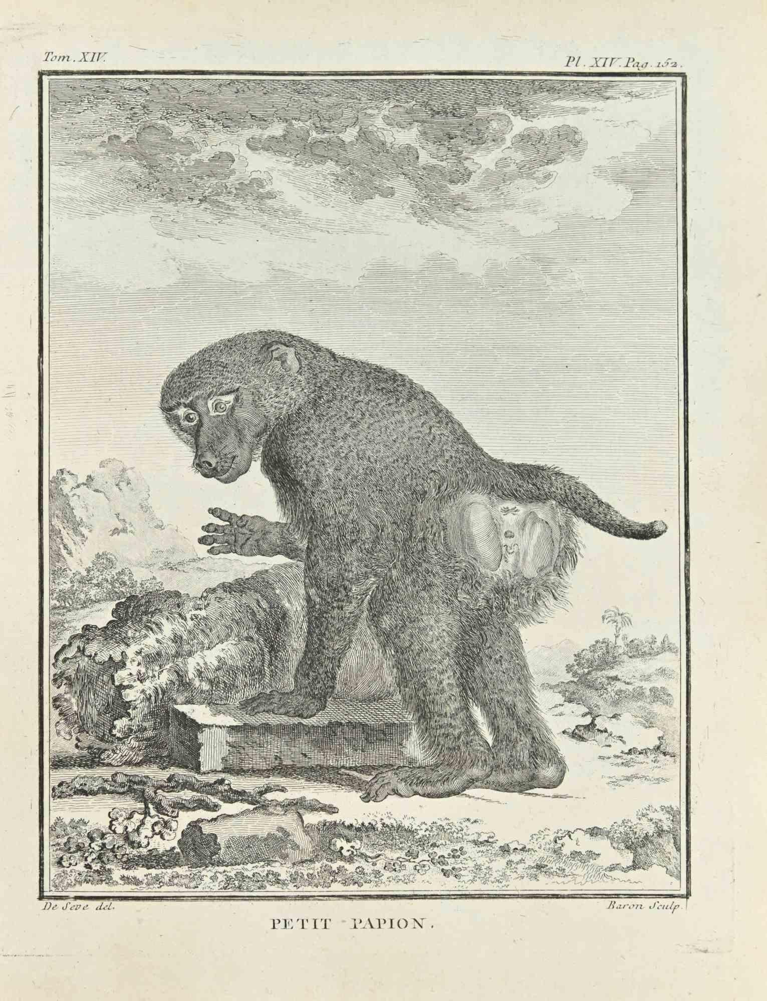
Petit Papion - Etching by Jacques Baron - 1771
Located in Roma, IT
Petit Papion is an etching realized by Jacques Baron in 1771.
The artwork Belongs to the suite "Histoire naturelle, générale et particulière avec la description du Cabinet du Roi". ...
Category
1770s Modern Figurative Prints
Materials
Etching