Items Similar to Asia Declineatio: A 17th Century Hand-colored Map of Asia by Justus Danckerts


Want more images or videos?
Request additional images or videos from the seller
1 of 9
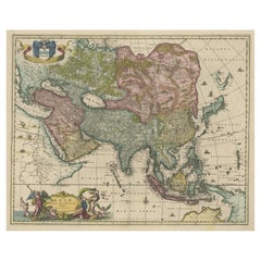
Justus DanckertsAsia Declineatio: A 17th Century Hand-colored Map of Asia by Justus Danckerts1685
1685
$1,580
£1,205.46
€1,378.52
CA$2,226.56
A$2,427.82
CHF 1,288.42
MX$29,351.59
NOK 16,305.90
SEK 14,946.63
DKK 10,296.12
About the Item
This is a scarce 17th century beautifully hand-colored copperplate engraved map of Asia entitled “Exactissima Asiae Delineatio in Praecipuas Regiones Caerterasque Partes divisa et denuo in lucem edita” by the Dutch cartographer Justus Danckerts. It was published in Amsterdam in 1685 in 'Atlas, Tot Amsterdam'. This very rare and attractive late 17th century map depicts Asia, India, Indonesia, the Maldives, East Indies, extending to northern Australia in the south, Japan in the west, the Mediterranean, the Red Sea, Arabia and Asia Minor in the east and Russia and China in the north. It includes a detailed view of Persia, Mongolia, Indonesia and the Philippines. The extent of European knowledge of the region is depicted reflecting the surveys of the Dutch East India Company. The work of the Jesuit missionaries is reflected in the well-documented region of China, while there is less information presented in northern and central Asia. Interesting projection of Japan and nice detail in China. The Philippines and Southeast Asian landmasses are disproportionately large, with the surrounding seas much smaller than actual size. The imaginary landmass "Yedso", also known as "Jesso", is depicted north of Japan. There is a colorful title cartouche in the lower left with a camel, apparent merchants and men working on packaged merchandise.
This rare strikingly attractive hand-colored map is printed on laid, chain-linked paper. The sheet measures 20" high and 23.38." wide. There is a central vertical fold, as issued. There is a short tear at the edge of the sheet in the lower left corner, professionally repaired on the verso and a small amount of color offset and discoloration. The map is otherwise in very good condition.
Justus Danckerts (1635-1701) was a Dutch cartographer and engraver who worked primarily in Amsterdam during the late 17th century. He was the son of the prominent mapmaker and engraver Cornelis Danckerts, and he continued his family's legacy by producing a wide range of maps, atlases, and prints. The Danckerts family of Amsterdam was one of the best known print and map sellers in 17th century Amsterdam. Their business activity covered the period from around 1633 when Cornelis Danckerts the elder (1603-1656) founded the business, to 1727 when the remaining stocks of maps in the shop of Theodorus Danckerts, his grandson, was sold. The house of Danckerts gained its greatest fame from Justus Danckerts (I. Danckerts), the maker of this map and the son of Cornelis. The majority of Danckert’s atlases were published between 1660 and 1720 and are very rare with very few complete copies surviving.
Justus Danckerts was known for his skill in engraving and printing techniques and for his high-quality, detailed and accurate maps, which were highly regarded by navigators, merchants, and scholars around the world. Danckerts produced a number of important maps and atlases during his career, including the "Atlas Novus" and the "Atlas Coelestis". He created maps of Europe, Asia, Africa, and the Americas, as well as city plans of Amsterdam, Paris, and other major European cities. Danckerts was also involved in the art trade and collected a number of valuable paintings, including works by Rembrandt and Vermeer. He was a member of the Amsterdam Guild of Saint Luke and held various civic positions in the city throughout his life. Today, Danckerts' maps and prints are highly sought after by collectors and are held in major museums and archives around the world. His contributions to cartography and printmaking continue to be appreciated and studied by scholars, collectors and enthusiasts alike.
- Creator:Justus Danckerts (1635 - 1701, Dutch)
- Creation Year:1685
- Dimensions:Height: 20 in (50.8 cm)Width: 23.38 in (59.39 cm)
- Medium:
- Movement & Style:
- Period:Late 17th Century
- Framing:Framing Options Available
- Condition:
- Gallery Location:Alamo, CA
- Reference Number:Seller: # 20151stDibs: LU1173211791172
About the Seller
5.0
Platinum Seller
Premium sellers with a 4.7+ rating and 24-hour response times
Established in 2011
1stDibs seller since 2019
298 sales on 1stDibs
Typical response time: 1 hour
- ShippingRetrieving quote...Shipping from: Alamo, CA
- Return Policy
More From This Seller
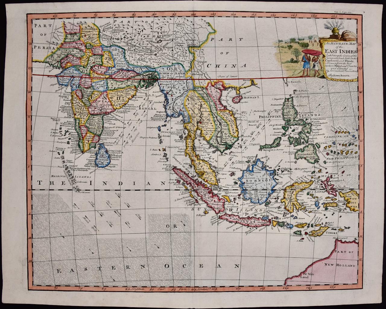
View AllMap of the East Indies: An Original 18th Century Hand-colored Map by E. Bowen
Located in Alamo, CA
This is an original 18th century hand-colored map entitled "An Accurate Map of the East Indies Exhibiting the Course of the European Trade both on the Continent and Islands" by Emanu...
Category
Mid-18th Century Old Masters Landscape Prints
Materials
Engraving

$1,020 Sale Price
20% Off
China: An Original 18th Century Hand-colored Map by E. Bowen
Located in Alamo, CA
This is an original 18th century hand-colored map entitled "A New & Accurate Map of China, Drawn from Surveys made by the Jesuit Missionaries, by order of the Emperor. The whole bein...
Category
Mid-18th Century Old Masters Landscape Prints
Materials
Engraving

Southern & Eastern Europe: A Large 17th C. Hand-colored Map by Sanson & Jaillot
By Nicholas Sanson d'Abbeville
Located in Alamo, CA
This large hand-colored map entitled "Estats de L'Empire des Turqs en Europe, ou sont les Beglerbeglicz our Gouvernements" was originally created by Nicholas Sanson d'Abbeville and this version was published by Hubert Jaillot in "Atlas Nouveau" in Paris in 1692. It depicts the territories of the Ottoman Empire in Europe, predominantly Eastern Europe. Highlights include, the Mediterranean Sea, the Adriatic Sea, the Black Sea, the Dalmation Coast including present day Croatia, Bosnia and Herzegovina, Montenegro, Serbia, Slovenia, Italy, Greece, North Macedonia, Turkey, Romania, Hungary, Albania, Kosovo, Bulgaria, Transylvania, Moldova and southern portions of France, Switzerland, Germany, and Poland..
The map consists of two sheets joined as one along a vertical joint. The map has original hand-coloring. It is printed on antique hand-made laid, chain-linked paper with wide margins. The sheet measures 24.88" high and 38" wide. There is a central vertical joint, as issued. The map is in very good condition.
Nicholas Sanson d'Abbeville (1600-1667) was one of the greatest French cartographather of French cartography. Sanson opened his first printing business in Paris in 1638. The king recognized his skill and knowledge and made him the official geographer to the court. He eventually served two kings in this capacity. Sanson was succeeded by his sons and son...
Category
1690s Landscape Prints
Materials
Engraving

Map of the World: An Original 18th Century Hand-colored Map by E. Bowen
Located in Alamo, CA
This is an original 18th century hand-colored map entitled "A New & Correct Chart of All The Known World Laid down according to Mercator's Projection" by Emanuel Bowen. It was published in 1744 in London in John Harris's "Navigantium atque Itinerantium Bibliotheca" or "A Complete Collection of Voyages and Travels". This highly detailed and colorful map depicts the world. as it was known in the mid 18th century. A majority of the northern and central portions of Canada and America are left blank due to the purity of knowledge at the time this map was published.
The map is embellished with four Compass Roses in the lower left, lower center, lower right and center, along with many rhumb lines. There a is a decorative title cartouche in the upper left. This colorful, attractive, historical and interesting 1744 map presents the entire world on Mercator's projection as it was understood in the middle part of the 18th century, before the landmark explorations of Captain’s Cook, Vancouver, Wilkes and others. It is an example of a nautical chart, a type of map that was designed specifically for use by mariners. The map is centered on the equator and includes both the Eastern and Western Hemispheres. The continents of North America, South America, Europe, Africa, and Asia are depicted, as well as various islands in the Atlantic, Pacific, and Indian Oceans. The map is laid out according to the Mercator projection, a type of cylindrical map projection that was developed in the 16th century by Flemish cartographer Gerardus Mercator. This projection has the advantage of preserving angles and shapes, making it useful for navigation. The map presents a paucity of inland detail, particularly for the Americas, but major cities, geographical landmarks, and regions are included. Ocean currents and Tradewinds are identified, as well as the magnetic declination lines or magnetic variance, which refers to the difference between true north and compass north. The continents are color coded, enhancing the beauty of this map. The three compass roses indicate the directions of the cardinal points.
The depiction of the western coast of America, the Pacific and Australia are interesting. There was very little exploration of Australia between the navigations of William Damper in 1699 and Tobias Furneaux in 1773. Most of the maps detail relies on the 17th century Dutch expeditions to Australia's western coast, by Abel Tasman and William Janszoon. Van Diemen's Land (Tasmania) and New Guinea appear connected to the Australian continent. New Zealand appears as a single landmass. North of New Zealand there is a landmass labelled 'Ter d' St. Esprit' which probably represents the New Hebrides Islands. This map precedes the accurate exploration of the South Pacific and east coast of Australia by Captain James Cook later in the 18th century. The map includes ‘Drakes' Port,' the site where Sir Francis Drake supposedly landed in 1579 during his 1579 circumnavigation of the globe. Here he claimed territory for England, restocked, and repaired his vessels. Drake named the region New Albion. The exact location of Drake's Port is a cartographic mystery. Drake's Harbor is believed to be in the region of San Francisco Bay, Bodega Bay, San Pablo Bay...
Category
Mid-18th Century Old Masters Landscape Prints
Materials
Engraving

Africa: A Large 17th Century Hand-colored Map By Sanson and Jaillot
By Nicholas Sanson d'Abbeville
Located in Alamo, CA
This large original hand-colored copperplate engraved map of Africa entitled "L'Afrique divisee suivant l'estendue de ses principales parties ou sont distingues les uns des autres, L...
Category
1690s Landscape Prints
Materials
Engraving

Map of the Russian Empire: An Original 18th Century Hand-colored Map by E. Bowen
Located in Alamo, CA
This is an original 18th century hand-colored map entitled "A New & Accurate Map of The Whole Russian Empire, As Contain'd Both In Europe and Asia, Drawn from Authentic Journals, Sur...
Category
Mid-18th Century Old Masters Landscape Prints
Materials
Engraving

You May Also Like
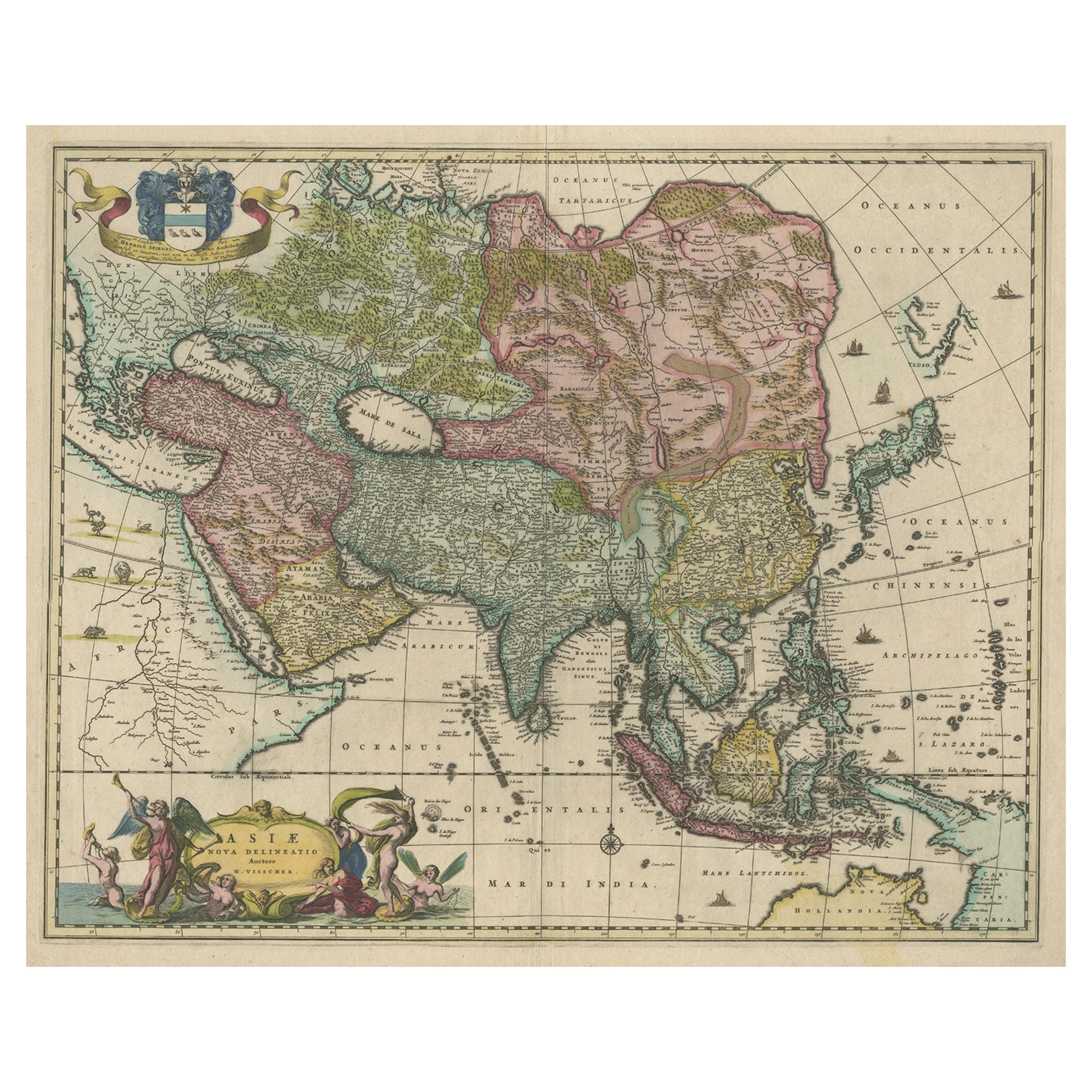
Antique Map of Asia and the East Indies and Korea as a Peninsula, ca.1660
Located in Langweer, NL
Antique map titled 'Asiae nova delineatio'. Decorative map of Asia and the East Indies. The map shows Korea as a peninsula. In China the Great Wall is depicted, as well as a long str...
Category
Antique 17th Century Maps
Materials
Paper
$2,393 Sale Price
20% Off
Free Shipping
Antique Duval Map of East Asia with China, Japan, Korea and the Great Wall, 1663
Located in Langweer, NL
Duval Asia Map 1663 China Japan Korea Great Wall Antique French Cartography
This elegant 17th-century map titled “L’Asie” is a finely executed French representation of the Asian continent by Pierre Duval, one of the foremost cartographers of Louis XIV’s France. Published in Paris in 1663, the map reflects a significant stage in European geographic knowledge, presenting Asia with increasing accuracy at a moment when global exploration, trade, and diplomatic contact were rapidly transforming Western understanding of the East.
Most of the place names shown represent geographical entities that still exist today or once existed historically, giving the map strong continuity between early modern geography and the modern world. Particularly notable is the improved rendering of Japan and the Korean peninsula, both shown with greater accuracy than in earlier 16th-century maps. The lower islands of Japan are better proportioned, and Korea is clearly depicted as a peninsula rather than an island, marking an important correction in European cartography.
China dominates the interior of the continent and is richly detailed with provinces, river systems, and cities. One of the most appealing features is the visible tracing of the Great Wall of China...
Category
Antique Mid-17th Century French Maps
Materials
Paper
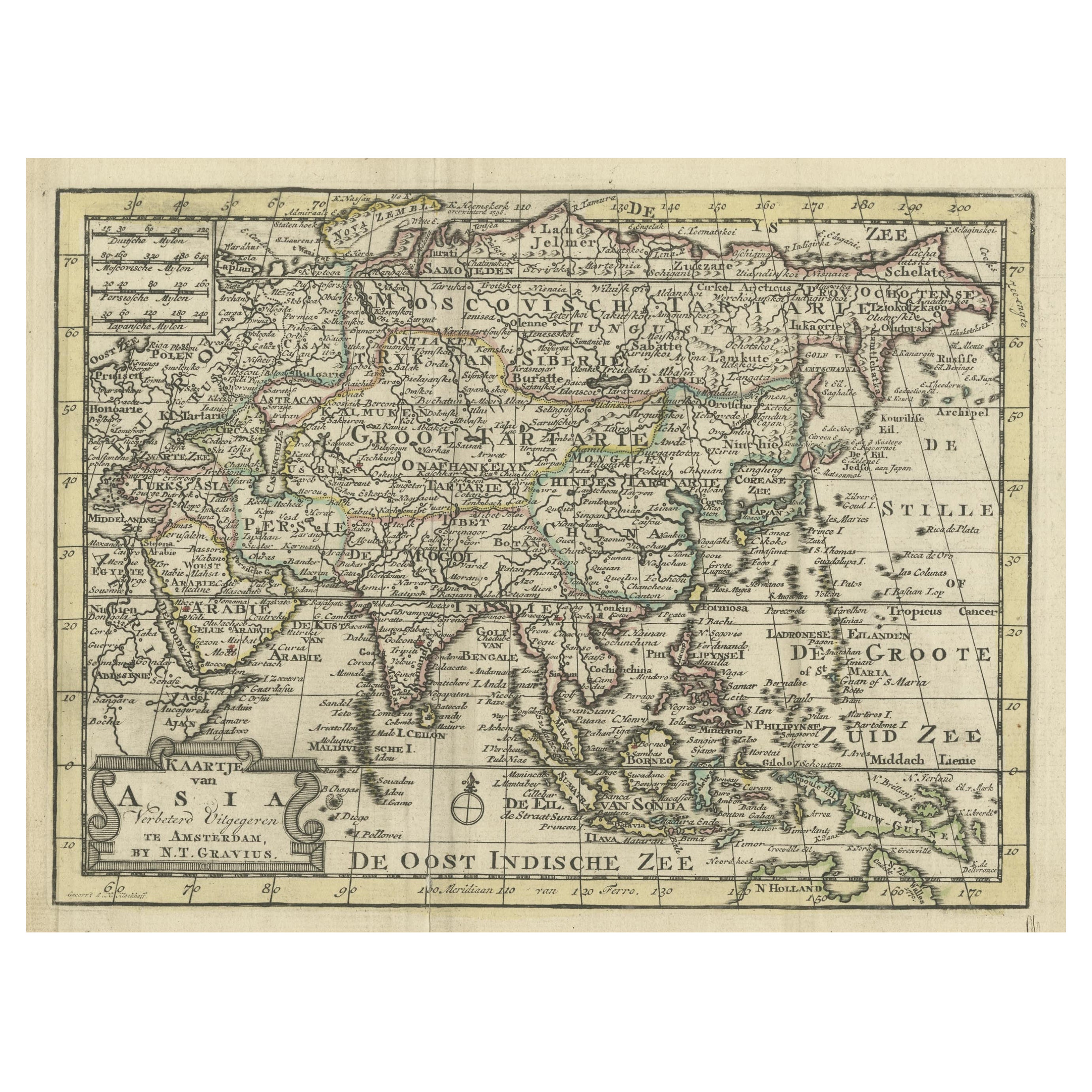
Rare Hand-Colored Antique Map of Asia, 1788
Located in Langweer, NL
Antique map titled 'Kaartje van Asia'.
Original antique map of Asia. This map originates from 'Nieuwe Natuur- Geschied- en Handelkundige Zak- en Reisatlas' by N.T. Gravius, 1788....
Category
Antique 1780s Maps
Materials
Paper
Antique Map of Asia by Tirion 'c.1760'
Located in Langweer, NL
Antique map titled 'Nuova Carta dell Asia'. Decorative map of Asia. Published by I. Tirion, circa 1760.
Category
Antique Mid-18th Century Maps
Materials
Paper

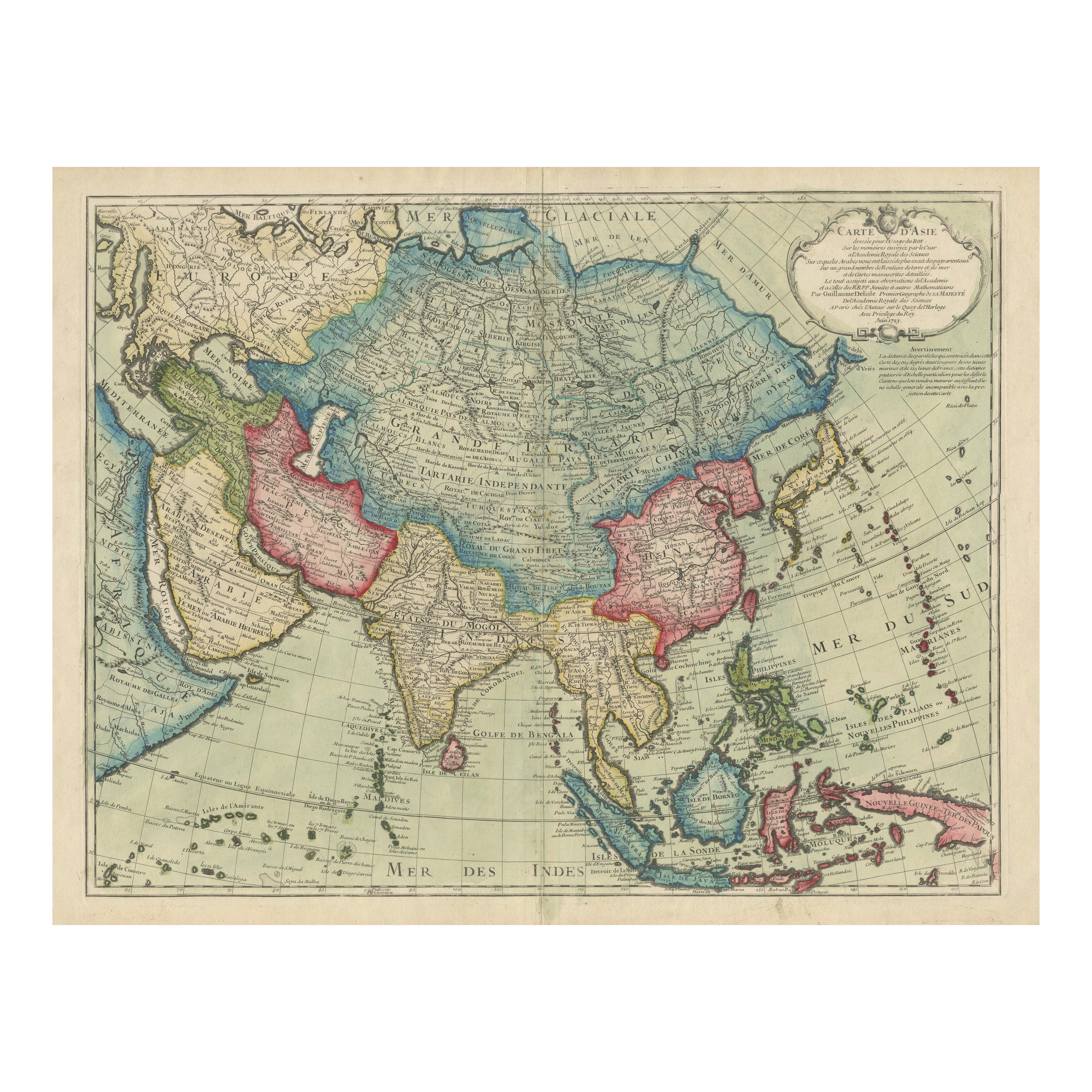
1723 Antique Map of Asia – Carte d’Asie by Guillaume Delisle, Paris
Located in Langweer, NL
Title: Carte d'Asie – Rare Hand-Colored Map of Asia by Guillaume Delisle, Paris 1723
Description:
This rare and highly decorative antique map titled 'Carte d'Asie', engraved and han...
Category
Antique Early 18th Century French Maps
Materials
Paper

Large Antique Map of Asia including All of Southeast Asia, c.1792
Located in Langweer, NL
Antique map titled 'L' Asie Divisee en ses Empires, Royaumes, et Etats'. Attractive, large map of Asia including all of Southeast Asia. The cartography is archaic for the period with...
Category
Antique 18th Century Maps
Materials
Paper

More Ways To Browse
Antique 17th Century Map
Asia Minor
Antique Navigator
Waterloo Anthonie
Axis Mundi
Banksy Walled Off Hotel
Banksy Walled Off
Cartier Poster
Dali Butterfly Suite
David Hockney Red
David Roberts Petra
Earlom Mezzotint
Ernest Roth Etching
Galerie 65 Cannes
Gloucester Etching
Hawaiian Prints Webber
Hoshi Joichi
J Torrents Llado