Items Similar to "Font-Romeu, " Original Color Lithograph Poster by Vincent Guerra


Want more images or videos?
Request additional images or videos from the seller
1 of 7
Vincent Guerra"Font-Romeu, " Original Color Lithograph Poster by Vincent Guerrac. 1925
c. 1925
$4,900
£3,712.68
€4,260.01
CA$6,895.09
A$7,579.60
CHF 3,983.49
MX$92,043.97
NOK 49,693.05
SEK 47,080.67
DKK 31,793.50
About the Item
"Font-Romeu (Tennis/Golfing Retreat)" is an original color lithograph poster by the designer Vincent Guerra. He signed the design in the lower left. This poster depicts a woman relaxing under a tree watching people in the distance play golf. The hotel and other amenities for this retreat can also be seen in the background.
39" x 24 1/4" art
47 3/4" x 33 3/4" frame
Vincent Guerra frequently created posters and lithographs advertising worldwide travel. Many of his posters were tied with the aviation company "Air France." The text at the top reads "Freshness - Rest" and the bottom advertises the Pyrenees mountains, which separates the Iberian peninsula and Spain from the rest of Europe. This particular resort is located at 1,800 meters.
- Creator:
- Creation Year:c. 1925
- Dimensions:Height: 47.75 in (121.29 cm)Width: 33.75 in (85.73 cm)
- Medium:
- Period:
- Condition:
- Gallery Location:Milwaukee, WI
- Reference Number:Seller: 10388g1stDibs: LU60532098943
About the Seller
4.9
Platinum Seller
Premium sellers with a 4.7+ rating and 24-hour response times
Established in 1966
1stDibs seller since 2017
447 sales on 1stDibs
Typical response time: 3 hours
- ShippingRetrieving quote...Shipping from: Milwaukee, WI
- Return Policy
Authenticity Guarantee
In the unlikely event there’s an issue with an item’s authenticity, contact us within 1 year for a full refund. DetailsMoney-Back Guarantee
If your item is not as described, is damaged in transit, or does not arrive, contact us within 7 days for a full refund. Details24-Hour Cancellation
You have a 24-hour grace period in which to reconsider your purchase, with no questions asked.Vetted Professional Sellers
Our world-class sellers must adhere to strict standards for service and quality, maintaining the integrity of our listings.Price-Match Guarantee
If you find that a seller listed the same item for a lower price elsewhere, we’ll match it.Trusted Global Delivery
Our best-in-class carrier network provides specialized shipping options worldwide, including custom delivery.More From This Seller
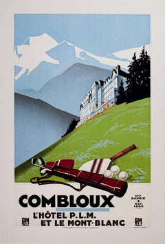
View All"Combloux (Golfing), " Original Lithograph Poster signed by Pierre Commarmond
By Pierre Commarmond
Located in Milwaukee, WI
"Combloux (Golfing)" is an original lithograph poster by Pierre Commarmond. Combloux is a resort in France where people can surround themselves with nature, leisure, and sport. The artist signed the lithograph stone...
Category
1920s Other Art Style Landscape Prints
Materials
Lithograph
"Italien Schweiz (Train), " Original Color Litho Poster signed by Aage Rasmussen
By Aage Rasmussen
Located in Milwaukee, WI
"Italien Schweiz (Train)" is an original color lithograph poster by Aage Rasmussen. It features a train speeding past landmarks of Italy.
39 1/4" x 24 1/4" art
49 1/2" x 33 5/8" fr...
Category
1950s Other Art Style Prints and Multiples
Materials
Lithograph

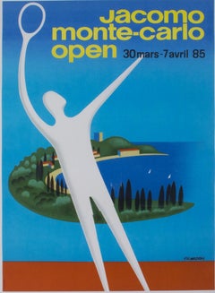
"Jacomo Monte-Carlo Open, " Original Lithograph Poster by Pierre Fix-Masseau
By Pierre Fix-Masseau
Located in Milwaukee, WI
"Jacomo Monte-Carlo Open" is an original lithograph poster by Pierre Fix-Masseau. The artist signed the piece in the image lower right. This poster advertises a tennis competition fr...
Category
1980s Art Deco Figurative Prints
Materials
Lithograph
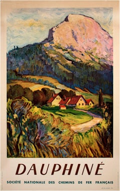
Early 20th century color lithograph poster mountain field houses trees sky text
By Paul Kelsch
Located in Milwaukee, WI
"Dauphine" is an offset lithograph of a pastoral landscape created by Paul Kelsch for the Societe Nationale des Chemis de fer Francais, the French National Railways.
24" x 39" paper
30 1/2" x 21 1/8" image
48" x 33" frame
Small hole in each corner, crease in paper and image upper left, small holes lower left.
The SNCF, the French National Rail system, commissioned multiple posters to advertise and celebrate the connected locations on their routes after the Second World War. "Dauphine", created by Paul Kelsch, showcases a small village at the foot of a mountain bathed in the light of a sunset. Kelsch's technique employed impasto brush strokes and bright colors to capture the beauty of the landscape. This scene is in stark contrast to the destruction that the war had wrought in this area during the 1944 invasion. Because of this, the set of posters...
Category
1940s Other Art Style Landscape Prints
Materials
Lithograph
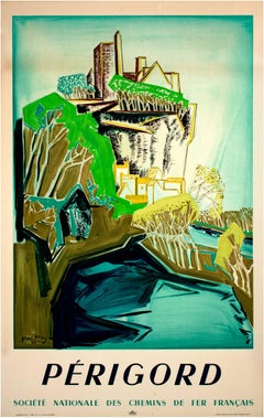
Early 20th century color lithograph poster mountain building trees sky text
By Edouard-Georges Mac-Avoy 1
Located in Milwaukee, WI
"Perigord" is an original lithograph of a landscape created for the Societe Nationale des Chemis de fer Francais, the French National Railways. Artist Eduoard Georges Mac'Avoy worked...
Category
1940s Landscape Prints
Materials
Lithograph
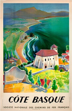
20th century color lithograph poster landscape pastoral building hills signed
By Vecoux
Located in Milwaukee, WI
"Cote Basque" is an original lithograph of the Basque region of France created by Vecoux for the Societe Nationale des Chemis de fer Francais, the French N...
Category
1940s Post-War Landscape Prints
Materials
Lithograph
You May Also Like
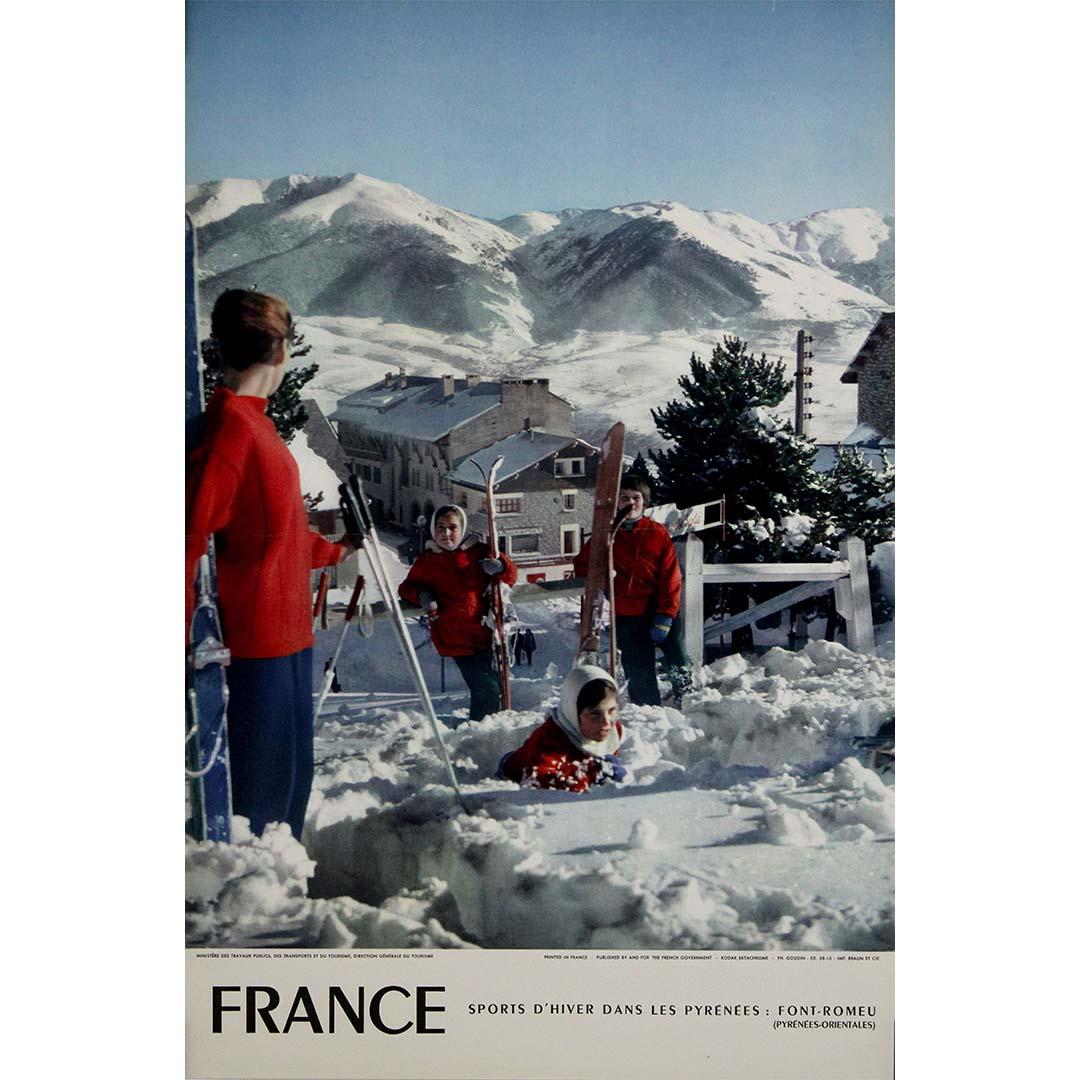
1958 vintage travel poster by Goudin Font-Romeu French Pyrenees
Located in PARIS, FR
This 1958 vintage travel poster, designed by Goudin, promotes Font-Romeu, one of the most renowned winter sports destinations in the French Pyrenees. Featuring a stunning photographi...
Category
1950s Prints and Multiples
Materials
Lithograph, Paper

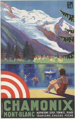
Original Chamonix Mont-Blanc vintage travel poster
Located in Spokane, WA
Original vintage travel poster Chamonix Mont-Blanc PLM French travel poster. Very good condition, archival linen backed. Ready to frame. ...
Category
1930s American Realist Landscape Prints
Materials
Lithograph
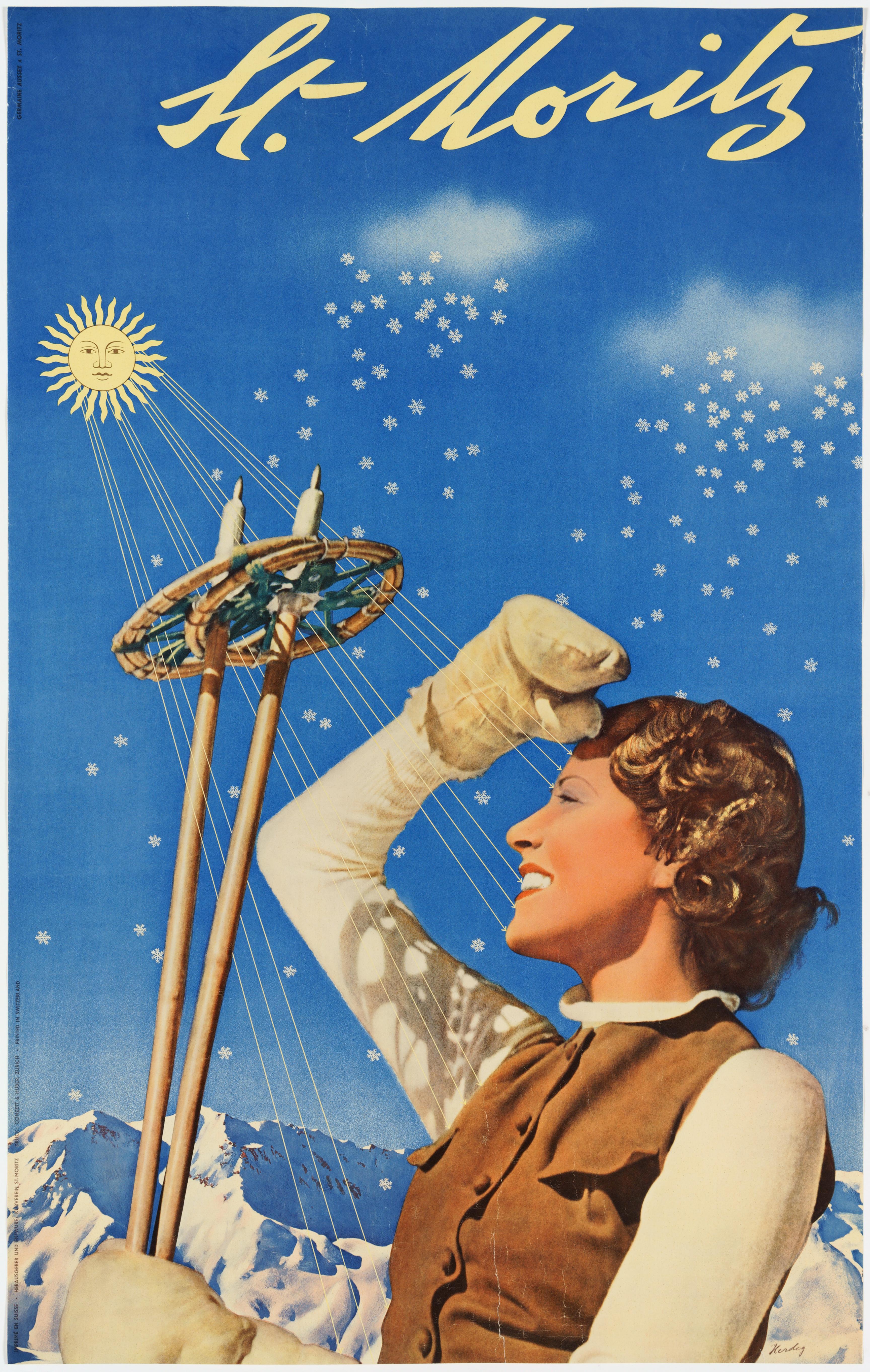
St. Moritz – Original Swiss Winter Poster
Located in Zurich, CH
Original Swiss Travel Poster promoting St. Moritz as winter destination, featuring Germaine Aussey, then a famous French actress.
Created by Walter Herdeg who – together with Herber...
Category
1930s Modern Landscape Prints
Materials
Paper

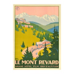
Original Vintage Travel Poster Le Mont Revard Grand Hotel PLM Roger Broders
By Roger Broders
Located in London, GB
Original vintage travel poster for Le Mont Revard Grand Hotel PLM 1550m d'Altitude issued by the PLM Paris Lyon Mediterranee railway featuring a stunning design by the notable French...
Category
Vintage 1920s French Posters
Materials
Paper
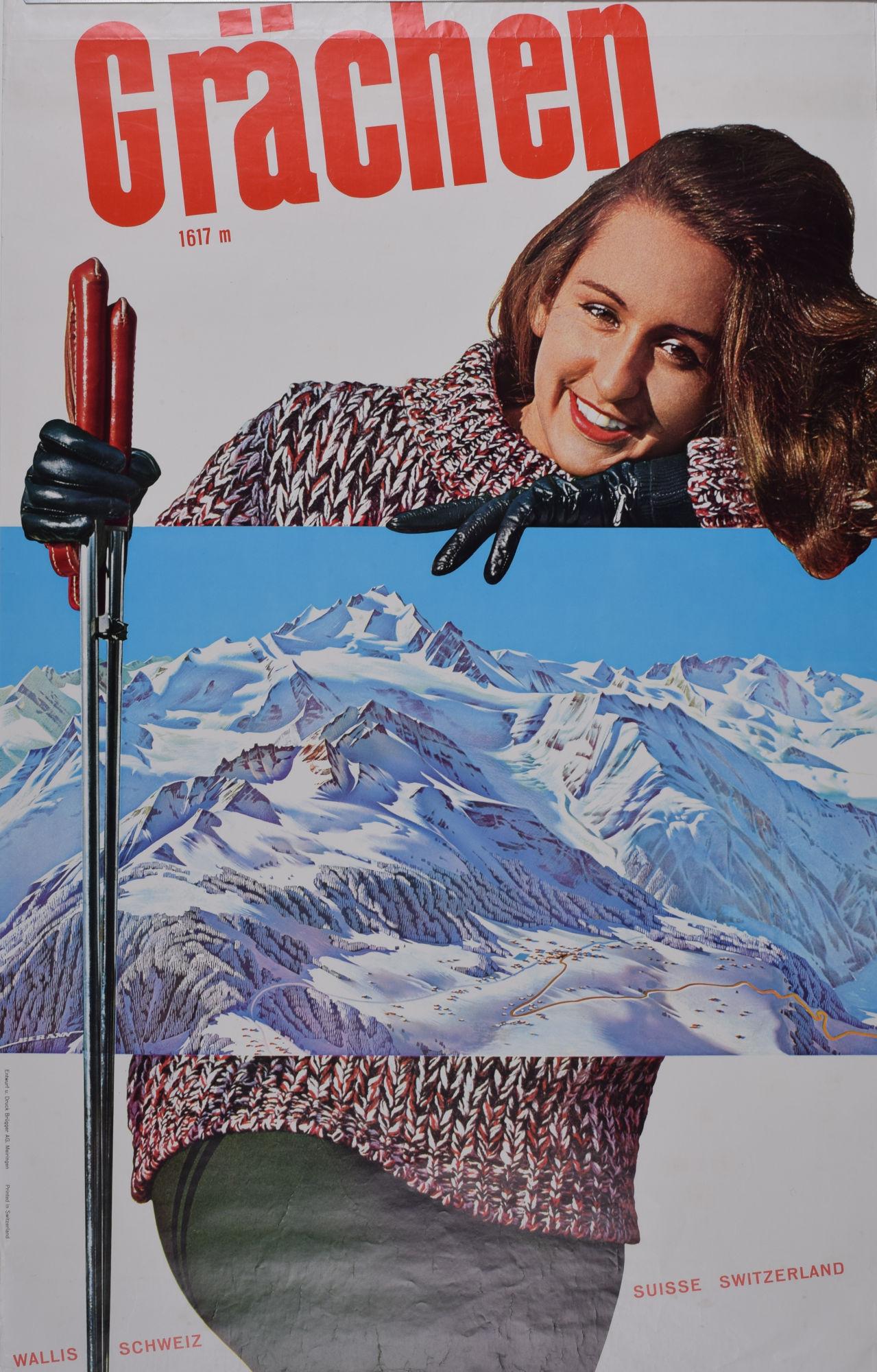
Grächen, Valais / Wallis, Switzerland original vintage skiing poster
Located in London, GB
To see our other original vintage travel posters, many of which feature ski resorts, scroll down to "More from this Seller" and below it click on "See all from this Seller" - or send...
Category
1960s Prints and Multiples
Materials
Lithograph

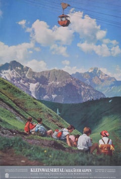
Austria Kleinwalsertal Allgauer Alpen vintage travel poster Kanzelwand
Located in London, GB
To see our other original vintage travel posters, scroll down to "More from this Seller" and below it click on "See all from this Seller" - or send us a message if you cannot find th...
Category
1970s Landscape Prints
Materials
Lithograph
More Ways To Browse
Antique Font
Peter Lind
Peter Max Kentucky Derby
Peter Max Mini
Pink Vintage Bathtub
Rick Dula On Sale
Robert Longo Wave
Ron Lawson
Rosamond Tudor On Sale
Rowena Fry
Roy Lichtenstein Sunrise
Salvador Dali The Alps
Salvador Dali Venice
Stephen McMillan On Sale
Stetson Etching
Thomas Kelly Print
Vintage Arsenal Posters
Vintage Standing Santa