Items Similar to 1944 statistical chart Larmat's Atlas de la France vinicole


Want more images or videos?
Request additional images or videos from the seller
1 of 8
Louis Larmat1944 statistical chart Larmat's Atlas de la France vinicole1944
1944
$903.14
£668.21
€750
CA$1,248.75
A$1,370.97
CHF 715.24
MX$16,590.69
NOK 8,964.42
SEK 8,446.84
DKK 5,710.52
About the Item
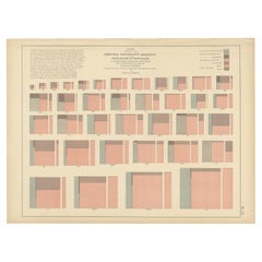
This 1944 historical statistical chart is an exceptional document from Larmat L.'s "Atlas de la France Vinicole – Les Vins de Champagne", presenting over a century of Champagne wine production and exports. Compiled from statistics recorded by Frédéric de Luze, it provides a detailed visual representation of Champagne trends from 1844 to 1944.
The document features two bar graphs, meticulously tracking key aspects of Champagne production and distribution:
1️⃣ The upper graph represents the annual Champagne exports, showing fluctuations in bottle shipments over time.
2️⃣ The lower graph illustrates the hectoliters of Champagne harvested in the Marne department, alongside vintage quality ratings for each year.
The legend on the left categorizes the quality of vintages, using a color-coded system:
🔴 Exceptional years
🟠 Very good years
🟡 Good years
🔵 Average years
⚫ Mediocre years
This unique statistical visualization captures the impact of historical events on Champagne production, including wars, economic fluctuations, and climate variations. Notably, periods of decline correspond with major conflicts such as World War I and World War II, which significantly disrupted production and exports. Conversely, the growth in Champagne shipments during prosperous eras reflects the rising global demand for France’s most celebrated sparkling wine.
🔹 Date: 1944
🔹 Publisher: Larmat L.
🔹 Statistical source: Frédéric de Luze
🔹 Subject: Champagne wine production & exports from 1844 to 1944
🔹 Medium: Printed chart with colored statistical indicators
🔹 Relevance: A vital reference for wine historians and collectors, providing insights into historical wine industry trends
With its scientific approach and elegant design, this mid-20th-century chart remains a valuable artifact for researchers, collectors, and Champagne enthusiasts, offering a detailed chronicle of the evolution of one of France’s most prestigious wine regions.
Alcohol - Marne - France
Statistics recorded by Fred. de Luze
Printed by Debar et Cie in Reims
- Creator:Louis Larmat
- Creation Year:1944
- Dimensions:Height: 13.39 in (34 cm)Width: 29.14 in (74 cm)
- Medium:
- Period:
- Condition:Good condition, original folds.
- Gallery Location:PARIS, FR
- Reference Number:1stDibs: LU1792215860182
About the Seller
5.0
Gold Seller
Premium sellers maintaining a 4.3+ rating and 24-hour response times
Established in 2021
1stDibs seller since 2022
174 sales on 1stDibs
Typical response time: 2 hours
- ShippingRetrieving quote...Shipping from: PARIS, France
- Return Policy
Authenticity Guarantee
In the unlikely event there’s an issue with an item’s authenticity, contact us within 1 year for a full refund. DetailsMoney-Back Guarantee
If your item is not as described, is damaged in transit, or does not arrive, contact us within 7 days for a full refund. Details24-Hour Cancellation
You have a 24-hour grace period in which to reconsider your purchase, with no questions asked.Vetted Professional Sellers
Our world-class sellers must adhere to strict standards for service and quality, maintaining the integrity of our listings.Price-Match Guarantee
If you find that a seller listed the same item for a lower price elsewhere, we’ll match it.Trusted Global Delivery
Our best-in-class carrier network provides specialized shipping options worldwide, including custom delivery.More From This Seller
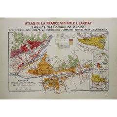
View All1946 original map "Les vins des côteaux de la Loire - Bourgueil" by Larmat
Located in PARIS, FR
The 1946 original map Atlas de la France Vinicole - Les Vins des Côteaux de la Loire: Bourgueil, St Nicolas-de-Bourgueil, Chinon, Montlouis, Jasnières, created by Louis Larmat and pr...
Category
1940s Prints and Multiples
Materials
Lithograph, Paper
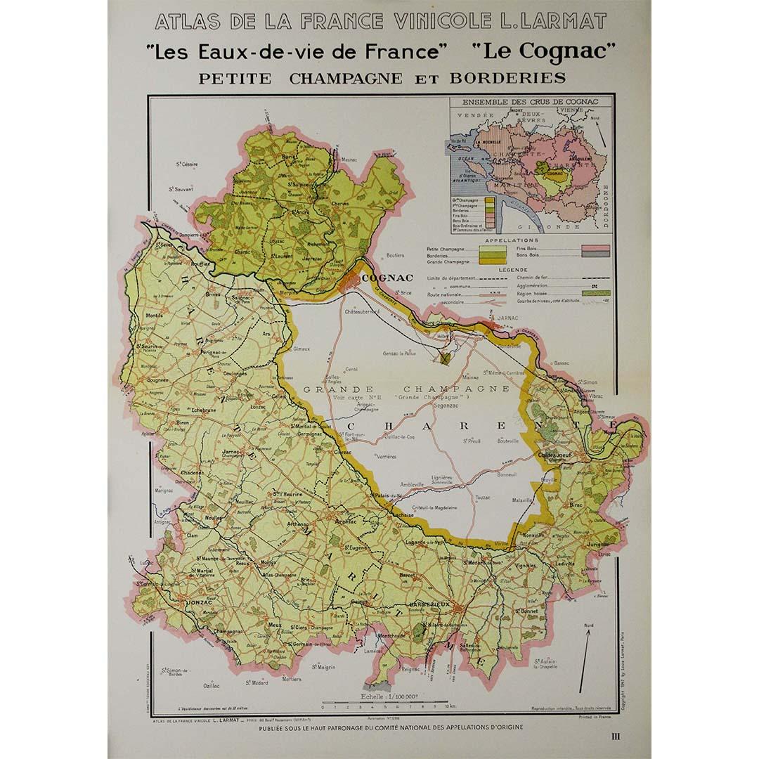
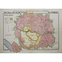
1947 original map "Les eaux-de-vie de France - Le Cognac fins bois" by Larmat
Located in PARIS, FR
The 1947 original map Atlas de la France Vinicole - Les Eaux-de-vie de France - Le Cognac Fins Bois, created by Louis Larmat and printed by Dorel in Paris, is an exquisite piece that...
Category
1940s Prints and Multiples
Materials
Lithograph, Paper
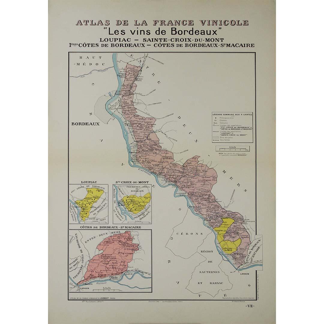
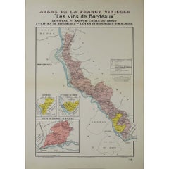
1941 original map "Les vins de Bordeaux - Loupiac, ..." by Larmat
Located in PARIS, FR
In 1941, L. Larmat crafted an exquisite map titled Atlas de la France Vinicole: Les Vins de Bordeaux - Loupiac, Sainte-Croix-du-Mont, Ières Côtes de Bordeaux, Côtes de Bordeaux St. M...
Category
1940s Prints and Multiples
Materials
Lithograph, Paper
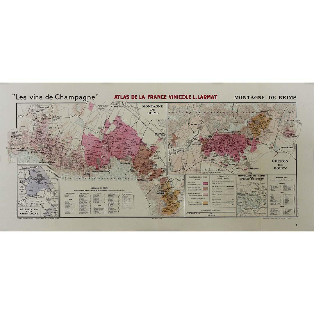
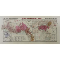
1944 original map "Les vins de Champagne – Montagne de Reims" by Louis Larmat
Located in PARIS, FR
The 1944 original map "Atlas de la France Vinicole – Les vins de Champagne – Montagne de Reims" by Louis Larmat is an exquisite piece of cartography that reflects both the history an...
Category
1940s Prints and Multiples
Materials
Lithograph, Paper
1947 original map Gouvernement Généraux du Poitou, du Pays d'Aunis
Located in PARIS, FR
The 1947 original map Gouvernement Généraux du Poitou, du Pays d'Aunis et de Saintonge Angoumois, created by Louis Larmat and printed by Dorel in Paris, is a beautifully detailed cartographic representation of a historically significant region in western France. This map, part of Larmat’s extensive body of work, is known for its artistic craftsmanship and geographical precision, offering a comprehensive view of the historical administrative regions of Poitou, Aunis, Saintonge, and Angoumois, which played key roles in the political and cultural history of France.
Louis Larmat is celebrated for his contributions to cartography, particularly for his ability to merge historical context, topographical detail, and aesthetic elegance in his maps. His works, especially those focusing on the vinicultural regions of France, are highly respected for their accuracy and artistry. This particular map, although focusing on a more political and historical aspect rather than the wine regions he is most famous for, continues his tradition of detailed regional documentation. Larmat’s cartographic works often transcended the realm of simple geographical depiction, becoming historical documents that encapsulate the cultural essence of the regions they portray.
This map illustrates the general governments (administrative divisions) of the provinces of Poitou, Aunis, Saintonge, and Angoumois, regions that are steeped in history. These areas, situated along France’s western coastline, have been integral to the country’s political, economic, and cultural development over centuries. The region of Poitou, for example, is historically known as the birthplace of Eleanor of Aquitaine...
Category
1940s Prints and Multiples
Materials
Lithograph, Paper

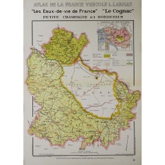
1947 original map "Les eaux-de-vie de France - Le Cognac petite Champagne"
Located in PARIS, FR
The 1947 original map Atlas de la France Vinicole - Les eaux-de-vie de France - Le Cognac Petite Champagne et Borderies, created by Louis Larmat and printed by Dorel in Paris, is a d...
Category
1940s Prints and Multiples
Materials
Lithograph, Paper
You May Also Like
Antique Map of France by Lapie, 1842
Located in Langweer, NL
Antique map titled 'Carte de France'. Map of France. This map originates from 'Atlas universel de géographie ancienne et moderne (..)' by Pierre M. Lapie and Alexandre E. Lapie. Pier...
Category
Antique Mid-19th Century Maps
Materials
Paper

$529 Sale Price
20% Off
Antique Chart of the Population of the United States by Walker '1874'
Located in Langweer, NL
Antique chart titled 'Chart showing the principal constitutional elements of the population of each state, as foreign, native, colored, and native white, and as born within or withou...
Category
Antique Late 19th Century Prints
Materials
Paper
$289 Sale Price
20% Off
Antique Map of France in Ancient Roman Times by d'Anville, c.1795
Located in Langweer, NL
Antique map titled 'Gallia Antiqua ex Aevi Romani Monumentis (..)'. Original, large, map of France in ancient Roman times. Bottom left, a large inset shows Gallia's southern most Rom...
Category
Antique Late 18th Century French Maps
Materials
Paper

$674 Sale Price
30% Off
Antique Map of France by Lapie, 1842
Located in Langweer, NL
Antique map titled 'Carte des Gaules'. Map of France. This map originates from 'Atlas universel de géographie ancienne et moderne (..)' by Pierre M. Lapie and Alexandre E. Lapie. Pie...
Category
Antique Mid-19th Century Maps
Materials
Paper

$481 Sale Price
20% Off
France in Departments - Lithograph - 1872
Located in Roma, IT
France in Departments is a map realized by an artist of the 19th century.
Lithograph, printed in 1872 by Milliam Mackenzie, London.
Category
1870s Modern Figurative Prints
Materials
Lithograph
France in Departments - Lithograph - 1872
Located in Roma, IT
France in Departments is an artwork realized by an artist of the 19th century.
Lithograph, printed in 1872 by Milliam Mackenzie, London.
Good condition.
Category
1870s Modern Figurative Prints
Materials
Lithograph
