Items Similar to The Netherlands (Holland), Belgium and Luxemburg. Century Atlas antique map
Want more images or videos?
Request additional images or videos from the seller
1 of 6
UnknownThe Netherlands (Holland), Belgium and Luxemburg. Century Atlas antique map1903
1903
$85
£64.40
€73.90
CA$119.61
A$131.48
CHF 69.10
MX$1,596.68
NOK 862.02
SEK 816.71
DKK 551.52
About the Item
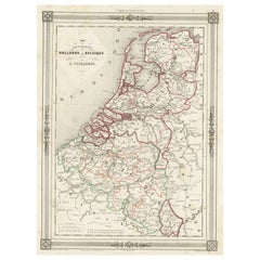
'The Century Atlas. The Netherlands (Holland), Belgium and Luxemburg.'
Original antique map, 1903.
Inset maps of 'Amsterdam' and 'Brussels'.
Central fold as issued. Map name and number printed on the reverse corners.
Sheet 40cm by 29.5cm.
- Creation Year:1903
- Dimensions:Height: 15.75 in (40 cm)Width: 11.62 in (29.5 cm)
- Medium:
- Movement & Style:
- Period:
- Condition:
- Gallery Location:Melbourne, AU
- Reference Number:1stDibs: LU1244211224912
About the Seller
5.0
Platinum Seller
Premium sellers with a 4.7+ rating and 24-hour response times
Established in 2005
1stDibs seller since 2019
613 sales on 1stDibs
Typical response time: <1 hour
- ShippingRetrieving quote...Shipping from: Melbourne, Australia
- Return Policy
Authenticity Guarantee
In the unlikely event there’s an issue with an item’s authenticity, contact us within 1 year for a full refund. DetailsMoney-Back Guarantee
If your item is not as described, is damaged in transit, or does not arrive, contact us within 7 days for a full refund. Details24-Hour Cancellation
You have a 24-hour grace period in which to reconsider your purchase, with no questions asked.Vetted Professional Sellers
Our world-class sellers must adhere to strict standards for service and quality, maintaining the integrity of our listings.Price-Match Guarantee
If you find that a seller listed the same item for a lower price elsewhere, we’ll match it.Trusted Global Delivery
Our best-in-class carrier network provides specialized shipping options worldwide, including custom delivery.More From This Seller
View AllFrance, Northern Part. Century Atlas antique map
Located in Melbourne, Victoria
'The Century Atlas. France, Northern Part.'
Original antique map, 1903.
Inset maps of 'France in Provinces' and 'Paris and Vicinity'.
Central fold as issued. Map name and number pr...
Category
Early 20th Century Victorian More Prints
Materials
Lithograph

German Empire, Northern Part. Century Atlas antique vintage map
Located in Melbourne, Victoria
'The Century Atlas. German Empire, Northern Part.'
Original antique map, 1903.
Central fold as issued. Map name and number printed on the reverse corne...
Category
Early 20th Century Victorian More Prints
Materials
Lithograph

German Empire, Southwestern Part. Century Atlas antique vintage map
Located in Melbourne, Victoria
'The Century Atlas. German Empire, Southwestern Part'
Original antique map, 1903.
Central fold as issued. Map name and number printed on the reverse co...
Category
Early 20th Century Victorian More Prints
Materials
Lithograph

Austria-Hungary, Western Part. Century Atlas antique vintage map
Located in Melbourne, Victoria
'The Century Atlas. Austria-Hungary, Western Part'
Original antique map, 1903.
Central fold as issued. Map name and number printed on the reverse corners.
Sheet 40cm by 29.5cm.
Category
Early 20th Century Victorian More Prints
Materials
Lithograph

Russia, Western and Southern Part. Century Atlas antique vintage map
Located in Melbourne, Victoria
'The Century Atlas. Russia, Western and Southern Part'
Original antique map, 1903.
Inset map tilted 'St Petersburg and Environs'.
Central fold as issued. Map name and number printe...
Category
Early 20th Century Victorian More Prints
Materials
Lithograph

Denmark. Century Atlas antique vintage map
Located in Melbourne, Victoria
'The Century Atlas. Denmark'
Original antique map, 1903.
Inset maps of 'Faroe Islands', 'Iceland' and 'Copenhagen'.
Central fold as issued. Map name and number printed on the reve...
Category
Early 20th Century Victorian More Prints
Materials
Lithograph

You May Also Like
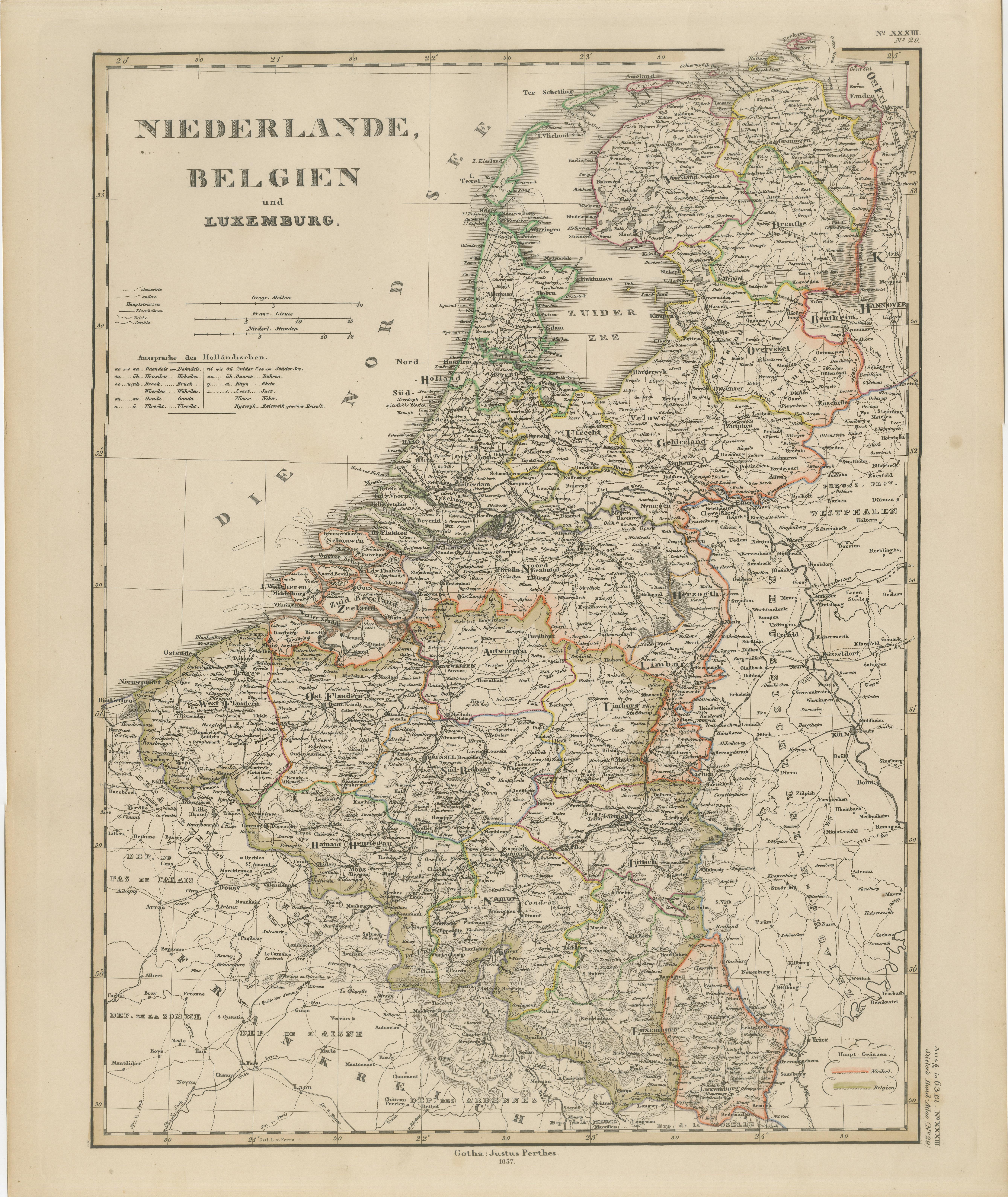
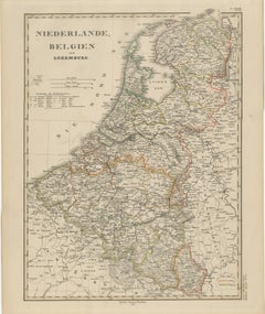
Benelux Antique Map – Netherlands, Belgium & Luxembourg by Perthes, 1857
Located in Langweer, NL
1857 Map of Netherlands, Belgium & Luxembourg – Justus Perthes Engraving
Antique map titled "Niederlande, Belgien und Luxemburg," published by Justus Perthes in Gotha in 1857. This...
Category
Antique Mid-19th Century German Maps
Materials
Paper
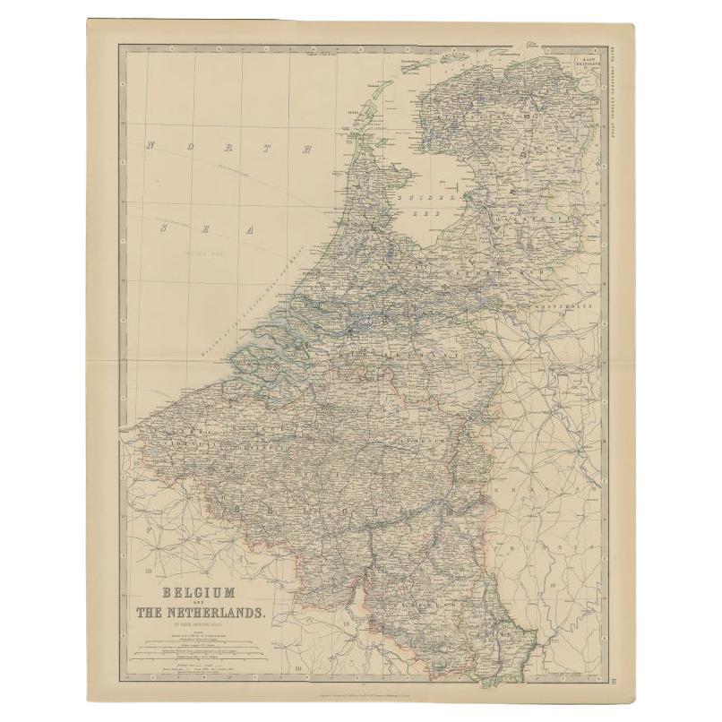
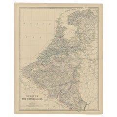
Antique Map of Belgium and the Netherlands by Johnston, 1882
By Alexander Keith Johnston
Located in Langweer, NL
Antique map titled 'Belgium and the Netherlands'. Old map of Belgium and the Netherlands. This map originates from 'The Royal Atlas of Modern Geography, Exhibiting, in a Series of En...
Category
Antique 19th Century Maps
Materials
Paper
$100 Sale Price
20% Off
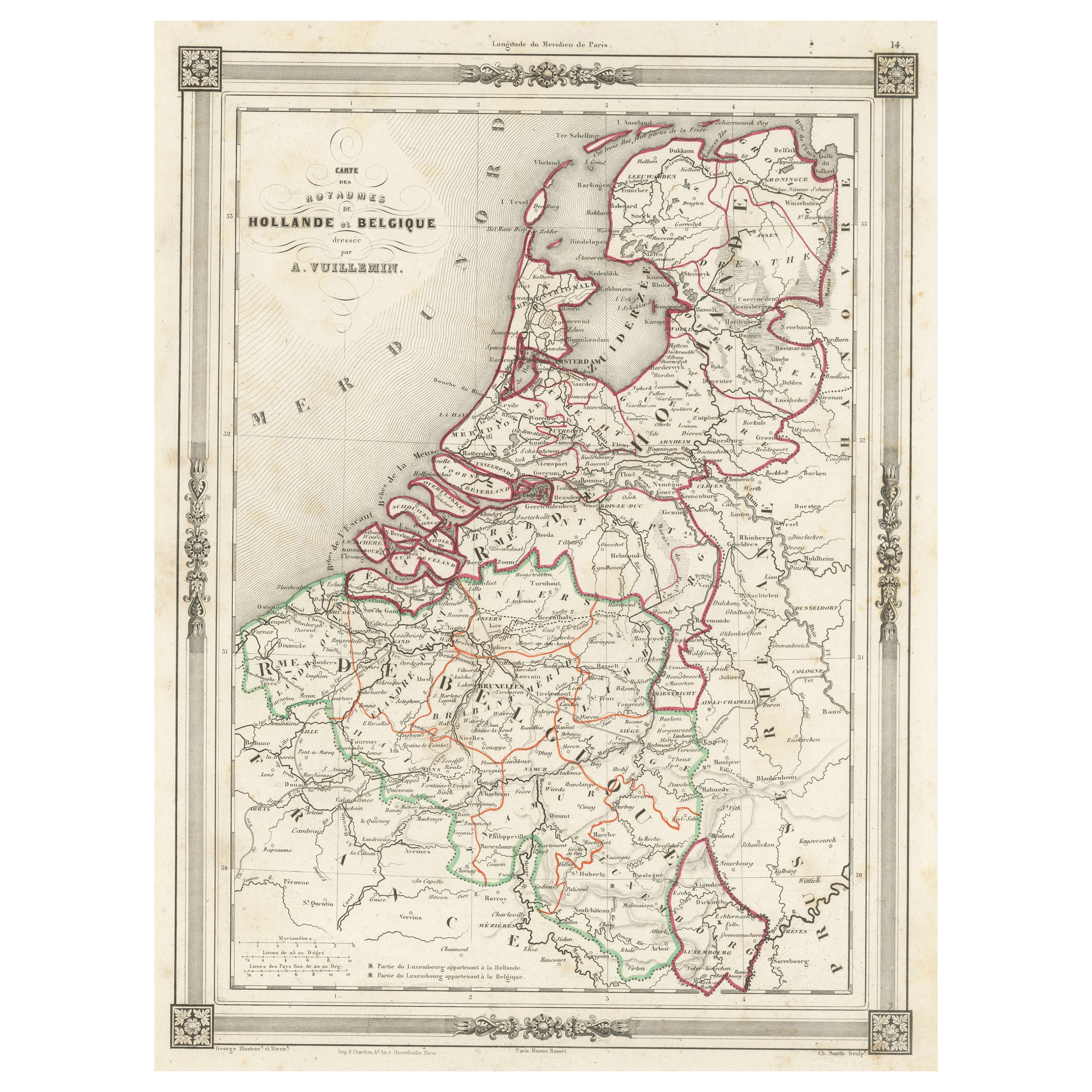
Antique Map of the Netherlands, Belgium and Luxembourg
Located in Langweer, NL
Antique map titled 'Carte des Royaumes Hollande et Belgique'. Attractive map of the Netherlands, Belgium and Luxembourg. This map originates fro...
Category
Antique Mid-19th Century Maps
Materials
Paper
$114 Sale Price
20% Off
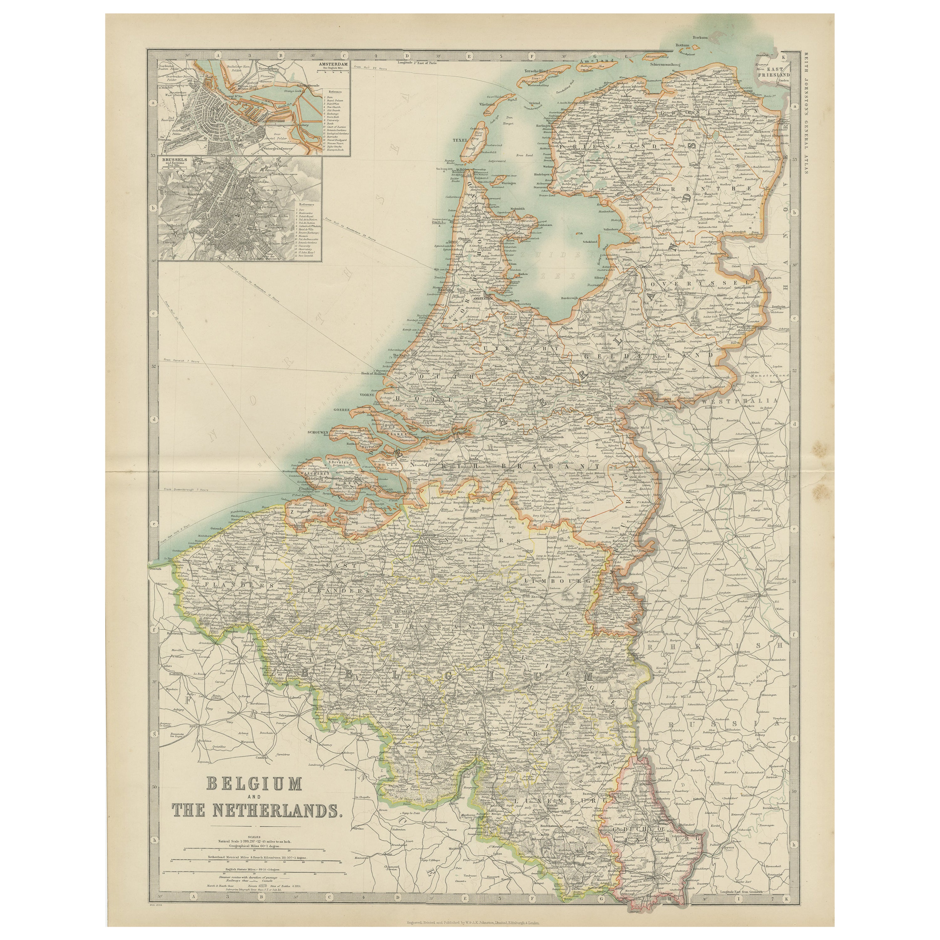
Antique Map of Belgium and the Netherlands by Johnston '1909'
Located in Langweer, NL
Antique map titled 'Belgium and The Netherlands'. Original antique map of Belgium and the Netherlands. With inset maps of Amsterdam and Brussels. This m...
Category
Early 20th Century Maps
Materials
Paper
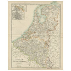
$239 Sale Price
20% Off
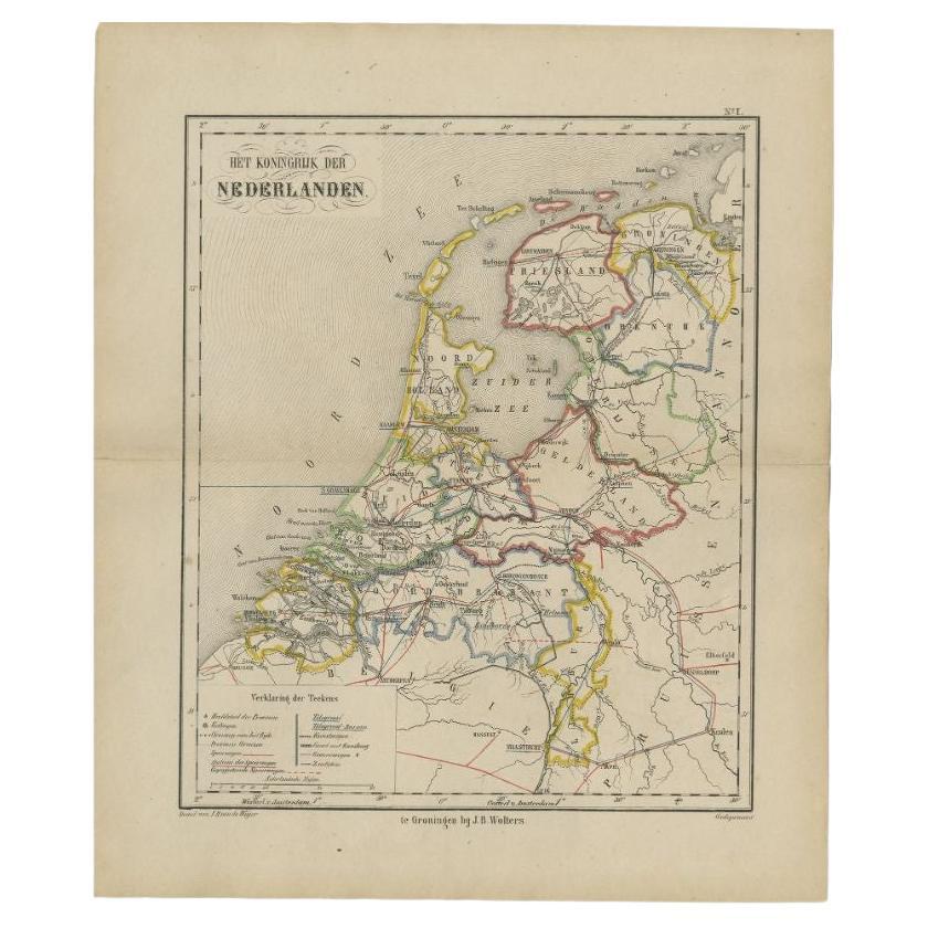
Antique Map of the Netherlands by Brugsma, 1864
Located in Langweer, NL
Antique map titled 'Het Koningrijk der Nederlanden'. Map of the Netherlands. This map originates from 'F. C. Brugsma's Atlas van het Koninkrijk ...
Category
Antique 19th Century Maps
Materials
Paper

$94 Sale Price
20% Off
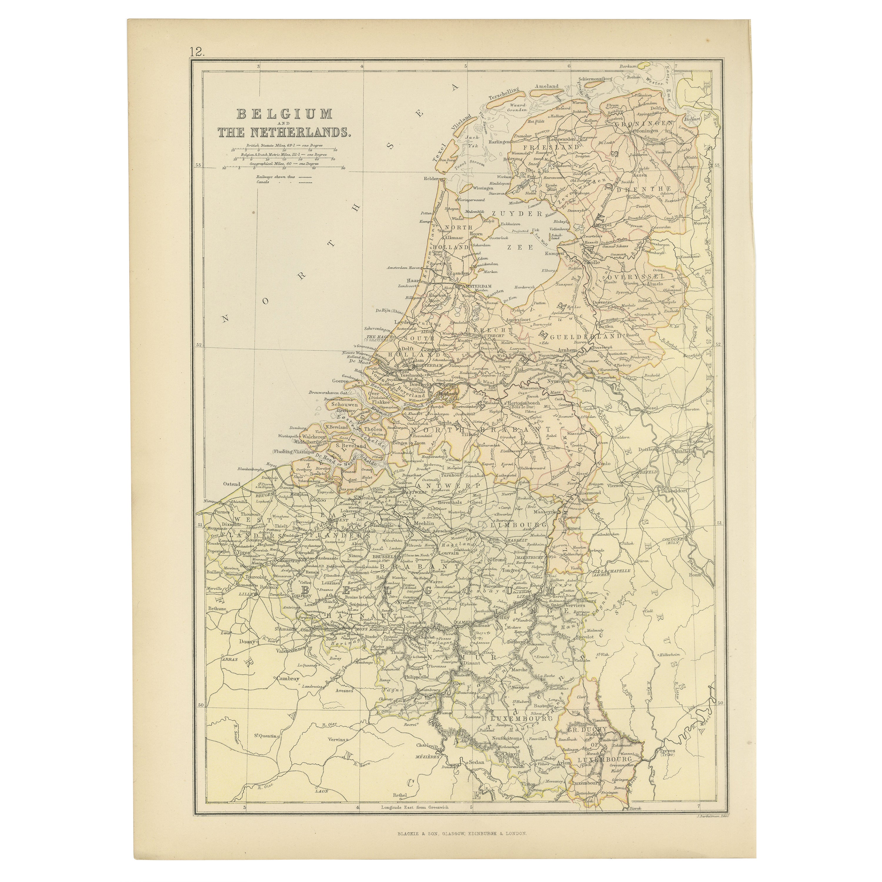
1882 Map of Belgium and The Netherlands Highlighting Geographical Details
Located in Langweer, NL
This 1882 map of Belgium and The Netherlands, published by Blackie and Son as part of the 'Comprehensive Atlas and Geography of the World,' offers a detailed representation of the tw...
Category
Antique 1880s Maps
Materials
Paper
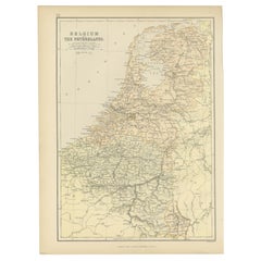
$181 Sale Price
20% Off
Free Shipping