Items Similar to Circa 1900 original poster Planisphère de géographie politique et commercial


Want more images or videos?
Request additional images or videos from the seller
1 of 8
UnknownCirca 1900 original poster Planisphère de géographie politique et commercialCirca 1900
Circa 1900
$1,673.86
£1,239.16
€1,400
CA$2,316.21
A$2,553.56
CHF 1,335.94
MX$31,327.50
NOK 16,816.87
SEK 15,726.43
DKK 10,664.34
About the Item
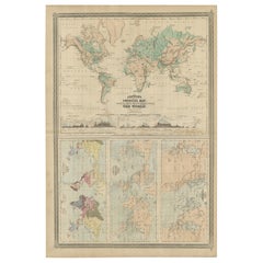
This circa 1900 original poster, "Planisphère de Géographie Politique et Commerciale," is a fascinating artifact of early 20th-century cartography, created by H. Bouthillier de Beaumont. The poster presents a detailed world map, rendered in a projection style that emphasizes the geopolitical and commercial landscapes of the era.
The "Planisphère" likely illustrates various trade routes, colonial territories, and key geopolitical regions, reflecting the global political and economic dynamics at the turn of the century. It serves as both an educational tool and a visual representation of the interconnectedness of the world, as understood at that time. The use of vibrant colors and precise detailing would have made it an essential reference for schools, businesses, and government institutions.
H. Bouthillier de Beaumont’s projection method ensures that the poster not only serves a functional purpose but also offers an aesthetically pleasing composition. The map likely includes annotations or legends that provide insights into the political boundaries and commercial networks of the period, offering a snapshot of the global landscape before the dramatic changes brought by the two World Wars.
For collectors and enthusiasts of historical cartography, this poster is a treasure. It captures a moment in time when the world was rapidly changing, and global commerce was expanding. The "Planisphère de Géographie Politique et Commerciale" is not just a map but a historical document that provides a window into the past, making it a valuable addition to any collection focused on geography, history, or early 20th-century educational materials.
Original Poster
Map - Railway - Telegraph
Projection by H. Bouthillier de Beaumont
Printed by F. Noverraz & fils in Geneva
- Creation Year:Circa 1900
- Dimensions:Height: 28.75 in (73 cm)Width: 35.44 in (90 cm)
- Medium:
- Period:
- Condition:Good condition, small tears.
- Gallery Location:PARIS, FR
- Reference Number:1stDibs: LU1792215650972
About the Seller
5.0
Gold Seller
Premium sellers maintaining a 4.3+ rating and 24-hour response times
Established in 2021
1stDibs seller since 2022
171 sales on 1stDibs
Typical response time: 1 hour
- ShippingRetrieving quote...Shipping from: PARIS, France
- Return Policy
Authenticity Guarantee
In the unlikely event there’s an issue with an item’s authenticity, contact us within 1 year for a full refund. DetailsMoney-Back Guarantee
If your item is not as described, is damaged in transit, or does not arrive, contact us within 7 days for a full refund. Details24-Hour Cancellation
You have a 24-hour grace period in which to reconsider your purchase, with no questions asked.Vetted Professional Sellers
Our world-class sellers must adhere to strict standards for service and quality, maintaining the integrity of our listings.Price-Match Guarantee
If you find that a seller listed the same item for a lower price elsewhere, we’ll match it.Trusted Global Delivery
Our best-in-class carrier network provides specialized shipping options worldwide, including custom delivery.More From This Seller
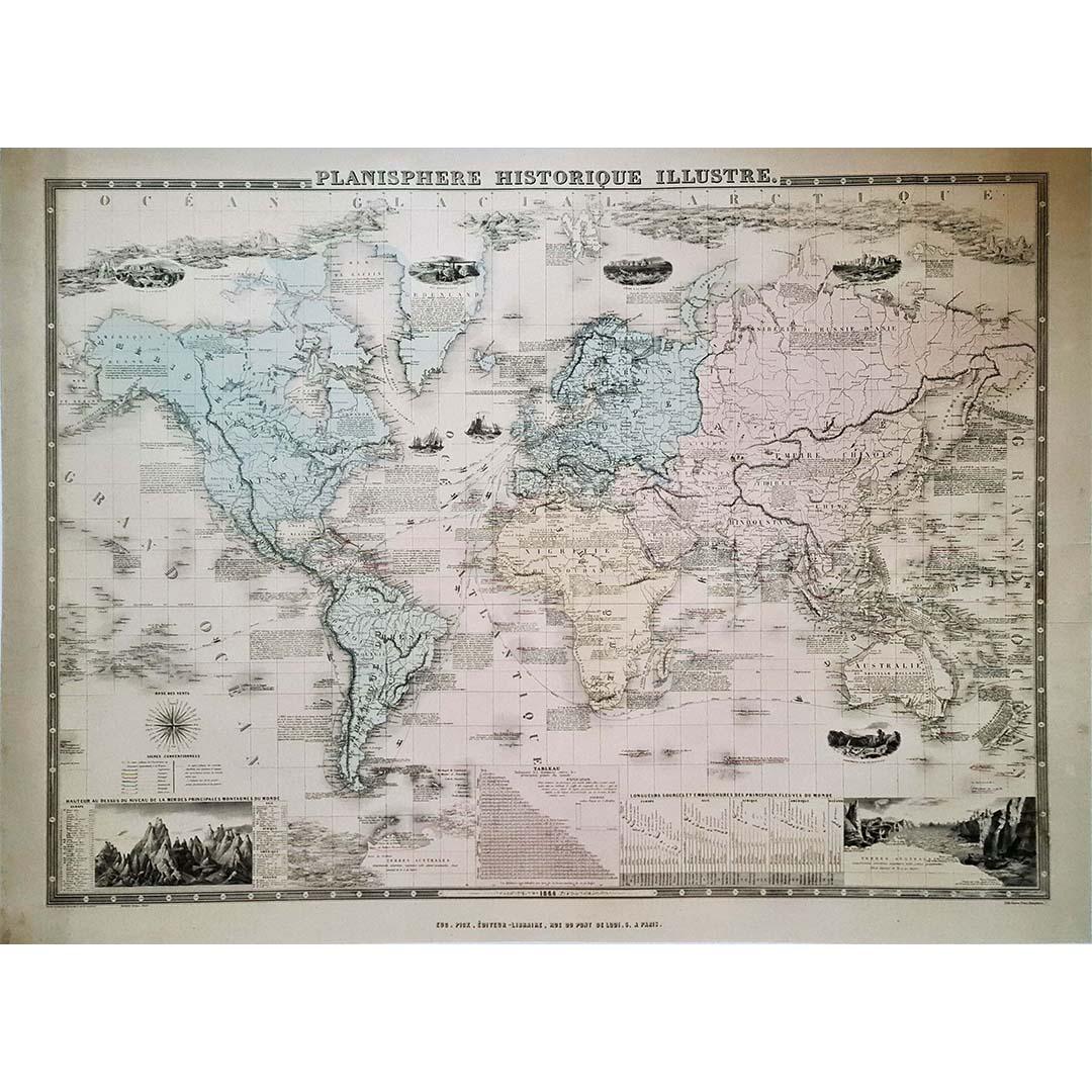
View All1864 Original illustrated planisphere - World Map - Geography
Located in PARIS, FR
Immerse yourself in the epic journey of the past with the Illustrated Historical Planisphere of 1864 by Charpentier! 🗺️ This cartographic treasure transports you through the intrica...
Category
1860s Prints and Multiples
Materials
Linen, Lithograph, Paper

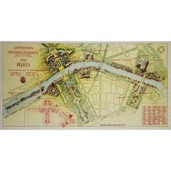
1937 original poster illustrated map of the Exposition Internationale
Located in PARIS, FR
This 1937 original poster presents a detailed illustrated map of the Exposition Internationale des Arts et Techniques dans la Vie Moderne, held in Paris. The International Exposition...
Category
1930s Prints and Multiples
Materials
Linen, Paper, Lithograph
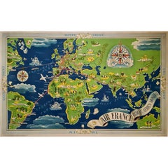
1937 Original planisphere by Lucien boucher - World map
By Lucien Boucher
Located in PARIS, FR
Original poster
Airline Company - Map - Tourism
West - Northern - Orient - Midi
In 1937, Lucien Boucher, a renowned French illustrator, unveiled his masterpiece, the "Planisphère ...
Category
1930s Prints and Multiples
Materials
Linen, Lithograph, Paper
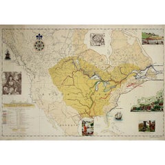
1935 original map French exploration in North America
Located in PARIS, FR
In 1935, a remarkable map titled "Les Français au Cœur de l'Amérique" was produced, highlighting the rich history of French exploration and influence in North America. This map is a ...
Category
1930s Prints and Multiples
Materials
Lithograph, Paper
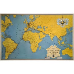
1938 original map titled "Carte du réseau aérien français" Air France
Located in PARIS, FR
The 1938 original map titled "Carte du réseau aérien français" by A. Collinet offers a captivating snapshot of Air France's global aviation network durin...
Category
1930s Prints and Multiples
Materials
Linen, Paper, Lithograph
1947 original map Gouvernement Généraux du Poitou, du Pays d'Aunis
Located in PARIS, FR
The 1947 original map Gouvernement Généraux du Poitou, du Pays d'Aunis et de Saintonge Angoumois, created by Louis Larmat and printed by Dorel in Paris, is a beautifully detailed cartographic representation of a historically significant region in western France. This map, part of Larmat’s extensive body of work, is known for its artistic craftsmanship and geographical precision, offering a comprehensive view of the historical administrative regions of Poitou, Aunis, Saintonge, and Angoumois, which played key roles in the political and cultural history of France.
Louis Larmat is celebrated for his contributions to cartography, particularly for his ability to merge historical context, topographical detail, and aesthetic elegance in his maps. His works, especially those focusing on the vinicultural regions of France, are highly respected for their accuracy and artistry. This particular map, although focusing on a more political and historical aspect rather than the wine regions he is most famous for, continues his tradition of detailed regional documentation. Larmat’s cartographic works often transcended the realm of simple geographical depiction, becoming historical documents that encapsulate the cultural essence of the regions they portray.
This map illustrates the general governments (administrative divisions) of the provinces of Poitou, Aunis, Saintonge, and Angoumois, regions that are steeped in history. These areas, situated along France’s western coastline, have been integral to the country’s political, economic, and cultural development over centuries. The region of Poitou, for example, is historically known as the birthplace of Eleanor of Aquitaine...
Category
1940s Prints and Multiples
Materials
Lithograph, Paper

You May Also Like
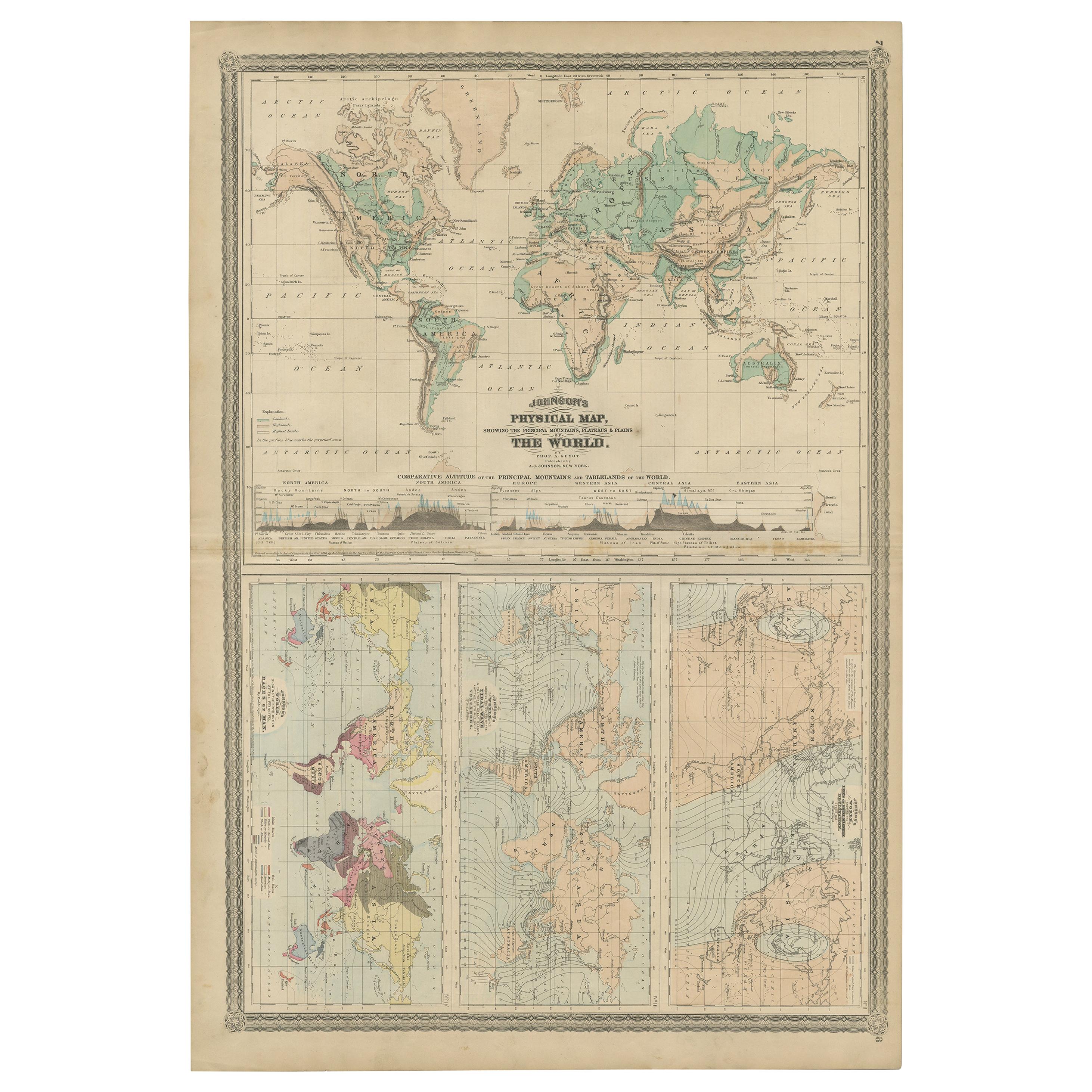
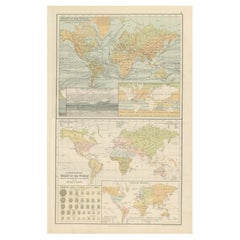
Four Physical Maps of the World on One Sheet , 1872
Located in Langweer, NL
Four physical maps of the world on one sheet. The upper map shows lowlands, highlands and highest lands. The other maps show world's races, ocean current and volcanoes, and magnetic ...
Category
Antique Late 19th Century Maps
Materials
Paper
$334 Sale Price
20% Off
Antique Map of The World in Hemispheres on Various Projections, 1882
Located in Langweer, NL
This stunning 1882 'Antique Map of The World in Hemispheres' showcases an exquisite blend of cartographic precision and artistic elegance. Crafted under the watchful eye of W.G. Blac...
Category
Antique 1880s Maps
Materials
Paper

$267 Sale Price
20% Off
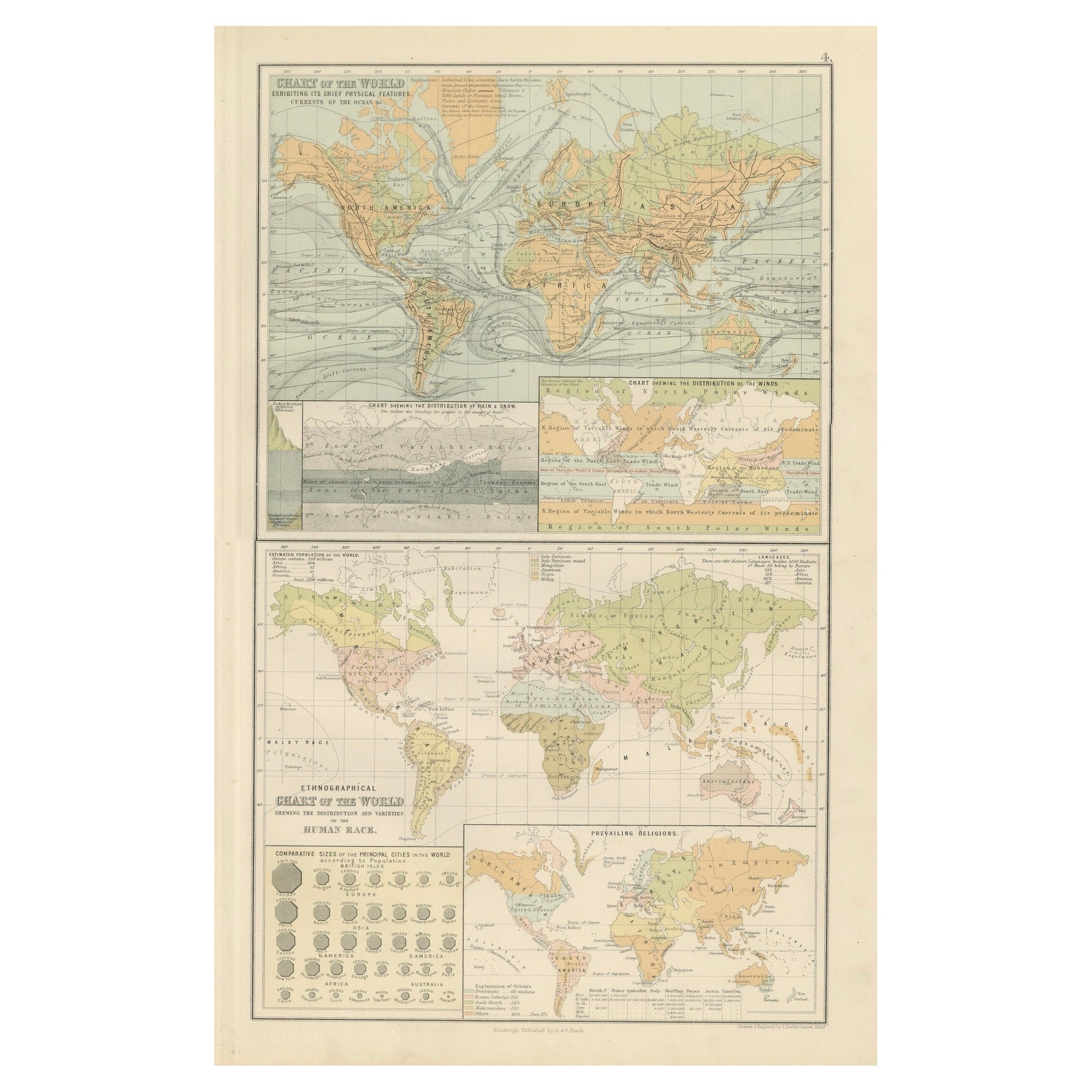
Antique Charts of the World – Physical Features and Ethnographical Map, 1884
Located in Langweer, NL
Antique Charts of the World – Physical Features and Ethnographical Map, 1884
Description:
This fascinating double plate from the New and Revised Edition of Black’s General Atlas of ...
Category
Antique 1880s Scottish Maps
Materials
Paper
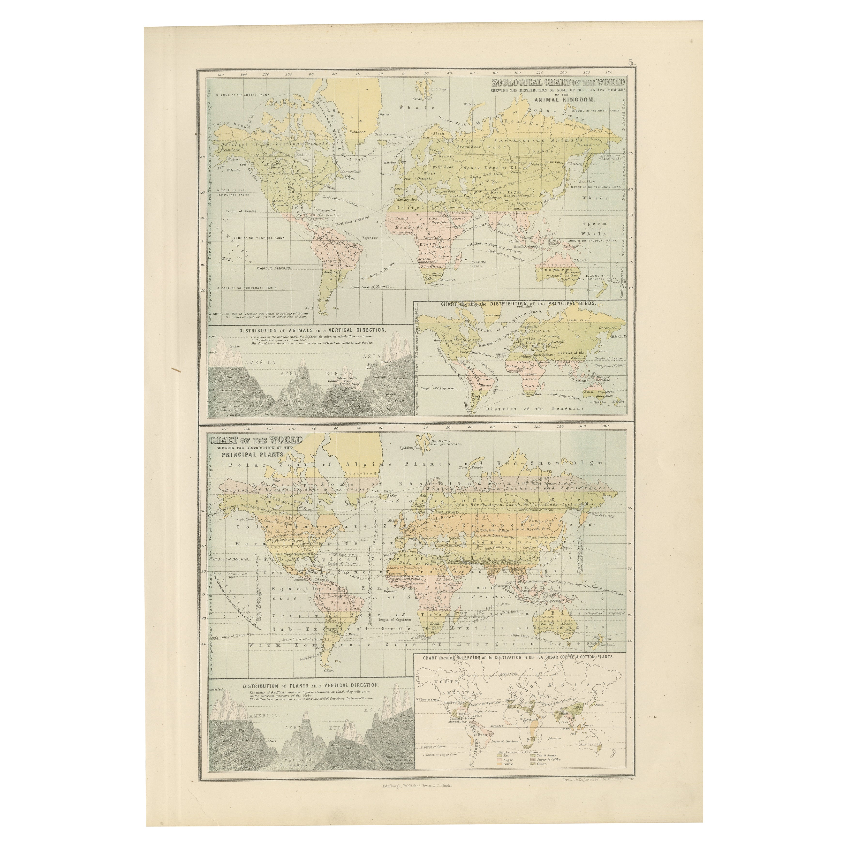
Antique Zoological and Botanical Chart of the World – Decorative Map, 1884
Located in Langweer, NL
Antique Zoological and Botanical Charts of the World – Black’s Atlas, 1884
This double plate from the New and Revised Edition of Black’s General Atlas of the World, published in Edi...
Category
Antique 1880s Scottish Maps
Materials
Paper
Antique Map of the World Showing the Distribution of Plants and Minerals, 1872
Located in Langweer, NL
Antique map titled 'Johnson's World showing the distribution of the Characteristic Forest Trees (..)'. Original world map showing the distribution o...
Category
Antique Late 19th Century Maps
Materials
Paper

$191 Sale Price
20% Off
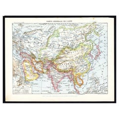
Antique Map of Asia by Larousse, 1897
Located in Langweer, NL
Front: 'Carte Generale de l'Asie.' (General map of Asia). Rear: 'Asie.' (Asia, scenes of Asia, nature, plants and animals, people, costume).' This rare early lithographic print origi...
Category
Antique 19th Century Maps
Materials
Paper
$71 Sale Price
20% Off
More Ways To Browse
Artifacts 20th Century
World Map Of Trade Routes
Railway Map
Antique Educational Posters
Antique Planisphere
Nestle Posters
Vintage Opera Poster
World War 2 Art
Andy Warhol Printed Signed
Gil Blas
Hotel Nacional
Italian Pool Shop
Japanese Woodblock Samurai
Kaws Lithograph
Keith Haring Dj
Matisse Blue Dancer
Namibian Sculpture
Oyvind Fahlstrom