Auctions
to
397
397
188
184
148
71
63
53
42
32
31
25
21
17
17
16
13
12
11
9
8
7
7
5
5
5
4
4
4
4
3
3
3
3
3
2
2
2
2
2
2
2
2
2
1
1
1
1
1
4
3
3
3
2
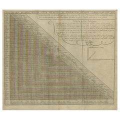
Antique Chart of Travelling Distances between European Cities, Ca.1792
Located in Langweer, NL
Antique print Europe titled 'Poliometria Europae Maxime Autem Germaniae ac Finitimorum Locorum'. This unusual chart depicts the traveling distances between various European cities.
...
Category
Antique 18th Century Maps
Materials
Paper
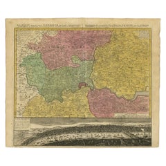
Antique Map of London Showing the Area from Essex to Surrey, England, 1741
Located in Langweer, NL
Antique map titled 'Regionis quae est circa Londinum specialis repraesentatio (..)'
Very detailed map showing the area from Essex to Surrey and shows a lovely view of London with a high level of detail, stretching from Old London Bridge...
Category
Antique 18th Century Maps
Materials
Paper
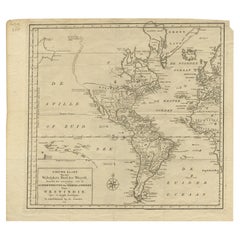
Excellent Antique Map of America with Unusual Northwest Coast of America, c.1754
Located in Langweer, NL
Description: Antique map titled 'Nieuwe Kaart Van het Westelykste Deel Der Weereld, dienende tot aanwyzing an de Scheepstogten der Nederlanderne Naar West Indie.' Excellent map of America, featuring an unusual northwest coast of America, which includes Martin d'Aguilar's strait which provides for a Northwest Passage via the Great Lakes. The rest of the NW coast...
Category
Antique 1750s Maps
Materials
Paper
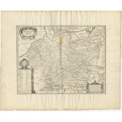
Antique Map of Germany of German in Roman Times, c.1660
Located in Langweer, NL
Antique map Germany titled 'Germaniae Veteris Typus'. Antique map probably by Blaeu or based on an earlier state by W. Blaeu.
Minor differences shown in the cartouches. Top left ha...
Category
Antique 17th Century Maps
Materials
Paper
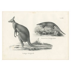
Antique Print of Kangaroo and a 'Javanese' Pangolin in Australia, c.1825
Located in Langweer, NL
A antique print depicting a 'Wolliger Kanguruh' (a kangaroo) and a 'Iavanisches Schuppenthier' (a Pangolin, a scaly anteater) from a German publication around 1825-1830.
Heinri...
Category
Antique 1820s Prints
Materials
Paper
Antique Botany Print of Saxifraga Stolonifera or Creeping Saxifrage, 1865
Located in Langweer, NL
Antique botany print of Saxifraga stolonifera, a perennial flowering plant known by several common names, including creeping saxifrage, strawberry saxifrage, creeping rockfoil and ot...
Category
Antique 19th Century Prints
Materials
Paper
Antique Map of Artois in the North of France by Famous Mapmaker Blaeu, c.1640
Located in Langweer, NL
Antique map titled 'Artesia Comitatus Artois'. Map of Artois or Artesia, France. Artois is former province located in the northwestern part of France, boarding Belgium (Flanders) on ...
Category
Antique 17th Century Maps
Materials
Paper
Antique Map of England and London with Two Large Allegorical Views, c.1720
Located in Langweer, NL
Antique map titled 'Nouvelle Carte du gouvernement civil d'Angleterre (..)'. Old plan of London, with map of England and two large allegorical views. This map originates from Chatela...
Category
Antique 18th Century Maps
Materials
Paper
Antique Map of Buckinghamshire in England, 1743
Located in Langweer, NL
Antique map titled 'Buckingham both shyre and shire towne describ'. Map of Buckinghamshire, England. With town plans of Buckingham and Redding. This map originates from Overton's atl...
Category
Antique 18th Century Maps
Materials
Paper
Map of Australia, New Zealand, Part of China, Japan and Southeast Asia, 1857
Located in Langweer, NL
German Antique map titled 'Australien'. Map of Australia, New Zealand, part of China, Japan and Southeast Asia. In the upper right is a bit of the California coast by San Francisco. ...
Category
Antique 19th Century Maps
Materials
Paper
Antique Map of a Bay on the Coast of Chile, South America, c.1749
Located in Langweer, NL
Antique map titled 'Plan van een Baai en Haven aan de Kust van Chili (..) - Plan d'une Baye de la Côte du Chili (..)'. Original antique map of a bay on the coast of Chile discovered ...
Category
Antique 18th Century Maps
Materials
Paper
Large Antique Map of Asia including All of Southeast Asia, c.1792
Located in Langweer, NL
Antique map titled 'L' Asie Divisee en ses Empires, Royaumes, et Etats'. Attractive, large map of Asia including all of Southeast Asia. The cartography is archaic for the period with...
Category
Antique 18th Century Maps
Materials
Paper
16th Century Map of Saudi Arabia, the Persian Gulf and Red Sea, ca. 1574
Located in Langweer, NL
Ptolemaic map of the Arabian Peninsula based on the 1548 map of Giacomo Gastaldi. It covers nearly all of the peninsula, but does not include the head of the Red Sea. The coastlines ...
Category
Antique 16th Century Maps
Materials
Paper
Antique Print of a Bouquet with Feverfew, Tulip and Anemone by Elwe '1794'
Located in Langweer, NL
Rare, original antique print of a bouquet of feverfew (Tanacetum species), tulip (Tulipa variegata) and anemone (Anemone flore simplici). Handcoloured copperplate botanical engraving...
Category
Antique Late 18th Century Prints
Materials
Paper
Vintage Botanical Treasures: Set of Three Flower Prints, circa 1930
Located in Langweer, NL
Set of three vintage flower prints. Little is known about these lovely prints, unsigned, no date. Aquarel? Published circa 1930.
Category
20th Century Prints
Materials
Paper
Vintage Geographic Splendor: 1859 Spain and Portugal
Located in Langweer, NL
The "Vintage Geographic Splendor: 1859 Spain and Portugal" map is an original antique piece from 'The Imperial Atlas of Modern Geography', published ...
Category
Antique Mid-19th Century Maps
Materials
Paper
Antique Map of Canada by Johnston '1909'
Located in Langweer, NL
Antique map titled 'Dominion of Canada'. Original antique map of Canada. This map originates from the ‘Royal Atlas of Modern Geography’. Publishe...
Category
Early 20th Century Maps
Materials
Paper
Original Antique Map of England and Wales from the 1909 Royal Atlas
Located in Langweer, NL
The antique map titled 'England and Wales' is a historical cartographic representation of these two nations. This original antique map of England...
Category
Early 20th Century Maps
Materials
Paper
Antique Map of West Canada by Tallis 'c.1850'
Located in Langweer, NL
Antique map titled 'West Canada'. Original antique map of West Canada, with decorative vignettes titled Kingston and Falls of Niagara. This map originates from 'The History and Topog...
Category
Antique Mid-19th Century Maps
Materials
Paper
Antique Chinese Rice Paper Pith Painting '19th Century'
Located in Langweer, NL
Antique Chinese rice paper pith painting. It shows a group gathering of men and women. Pith paper is made from the inner pith of the plant Tetrapane...
Category
Antique 19th Century Prints
Materials
Paper
Antique Chinese Rice Paper Pith Painting of Men and Women '19th century'
Located in Langweer, NL
The image portrays a detailed antique Chinese rice paper pith painting, a unique art form popular in the 19th century, especially for export to the ...
Category
Antique 19th Century Prints
Materials
Paper
Antique Print of Soldiers of the 11th and 12th Century by Strutt '1842'
Located in Langweer, NL
Antique print titled 'Soldiers of the Eleventh & Twelfth Centuries'. Original antique print of Soldiers of the 11th and 12th Century. This print originates from 'Illustration for Dre...
Category
Antique Mid-19th Century Prints
Materials
Paper
Antique Botany Print in Frame of Narcissus Tazetta or Polyanthus Narcissus, 1806
Located in Langweer, NL
Antique botany print of Narcissus Tazetta or Polyanthus Narcissus by William Curtis.
William Curtis began publication of the Botanical Magazine in February 1787 and continued almost without interruption for 160 years. After Curtis edited the first 13 volumes, the publication continued under the editors: John Simms (1800-1826), William Jackson Hooker (1827-1865) and Joseph Dalton Hooker (1865-1904). The images were engraved and hand-coloured by many artists including Sydenham Edwards, William Graves, James Sowerby, John Curtis, William Jackson Hooker, W.H. Fitch, Matilda Smith, Lillian Snelling...
Category
Antique Early 19th Century Prints
Materials
Paper
Antique Print of the Winning Horse 'Satirist' and a Jockey '1841'
Located in Langweer, NL
Antique horse print titled 'Satirist, winner of the Great St. Leger at Doncaster, 1841'. This aquatint print shows a winning horse and jockey of the Grea...
Category
Antique Mid-19th Century Prints
Materials
Paper
Antique Print of the Winning Horse 'Nutwith' and a Jockey 'c.1840'
Located in Langweer, NL
Antique horse print titled 'Nutwith the winner of the Great St. Leger Stakes at Doncaster, 1843'. This aquatint print shows a winning horse and jockey of...
Category
Antique Mid-19th Century Prints
Materials
Paper
Set of 9 Antique Costume Prints, Turkey, Albania, Anatolia, 'c.1840'
Located in Langweer, NL
Set of nine antique costume prints including costumes of Turkey, Albania, Anatolia and others. Source unknown, to be determined. Published circa 1840.
Category
Antique Mid-19th Century Prints
Materials
Paper
Antique Print of Hop Pickers at Work after A. Hunt, 'c.1880'
Located in Langweer, NL
Antique print titled 'Hop Picking'. Original antique print of hop pickers at work. Men and women work in the hop fields, possibly in Kent or Surrey, England. Right, two gentlemen buy...
Category
Antique Late 19th Century Prints
Materials
Paper
Antique Map of the World, Mercator Projection, by Wyld, '1845'
Located in Langweer, NL
Antique map titled 'The World'. Original antique world map, on Mercator's projection. This map originates from 'An Atlas of the World, Compr...
Category
Antique Mid-19th Century Maps
Materials
Paper
Antique Map of South America by Wyld, '1845'
Located in Langweer, NL
Antique map titled 'South America'. Original antique map of South America. This map originates from 'An Atlas of the World, Comprehending ...
Category
Antique Mid-19th Century Maps
Materials
Paper
Antique Map of the Eastern Hemisphere by Wyld '1845'
Located in Langweer, NL
Antique map titled 'Eastern Hemisphere'. Original antique map of the eastern hemisphere. This map originates from 'An Atlas of the World, Comprehending Separate Maps of its...
Category
Antique Mid-19th Century Maps
Materials
Paper
Antique Map of the Kingdom of the Netherlands by Wyld '1845'
Located in Langweer, NL
Antique map titled 'Holland & Belgium formerly Kingdom of the Netherlands'. Original antique map of the Kingdom of the Netherlands. This map originates from 'An Atlas of the World, C...
Category
Antique Mid-19th Century Maps
Materials
Paper
Antique Map of Europe by Wyld '1845'
Located in Langweer, NL
Antique map titled 'Europe'. Original antique map of Europe. This map originates from 'An Atlas of the World, Comprehending Separate Maps of its ...
Category
Antique Mid-19th Century Maps
Materials
Paper
Antique Map of the West Indies by Wyld '1845'
Located in Langweer, NL
Antique map titled 'Map of the West India Islands'. Original antique map of the West Indies, including Cuba, the Bahamas, the Antilles a...
Category
Antique Mid-19th Century Maps
Materials
Paper
Antique Map of the Philippines by Anson '1749'
Located in Langweer, NL
Antique map titled 'Carte du Canal des Iles Philippines - Kaart van het Kanaal in de Filippynsche Eilanden'. Large detailed chart of the islands of the Philippines. One of the most detailed charts of the Philippines of the era. Shows Islands, bays, reefs, soundings tracks of the Manila Galleon route, etc. Includes a large compass...
Category
Antique Mid-18th Century Maps
Materials
Paper
Antique Print of Zihuatanejo and the Harbour of Acapulco by Anson '1749'
Located in Langweer, NL
Antique print titled 'Vue de l'entree de Chequetan ou Seguataneo, restant au N.E. a la distance de 5 milles.' 'Vue de l'entree du port d'Acapulco.' View of Zihuatanejo and the harbou...
Category
Antique Mid-18th Century Prints
Materials
Paper
Antique Map of Juan Fernandez Island by Anson '1749'
Located in Langweer, NL
Antique map titled 'l'Ile de Juan Fernandes dans la Mer du Sud (..) - Het Eiland Juan Fernandes in de Zuid Zee (..)'. This map depicts Juan Fernandez Island in the Southern Sea. This...
Category
Antique Mid-18th Century Maps
Materials
Paper
Antique Map of Coiba Island by Anson '1749'
Located in Langweer, NL
Antique map titled 'Plan van de Oost-Zyde van het Eiland Quibo'. Original antique map of the eastside of Coiba Island (Quibo), Panama, showing the shoreline around Port de Dames indi...
Category
Antique Mid-18th Century Maps
Materials
Paper
Antique Map of Juan Fernandez Island and Cumberland Bay, Chile - c. '1749'
Located in Langweer, NL
Antique map titled 'Plan de la Côte du N.E. de l 'Ile de Juan Fernandes - Schets van den Noord-Oost kant van het eiland Juan Fernandes '. This map depicts the northeast coast of the ...
Category
Antique Mid-18th Century Maps
Materials
Paper
Antique Print of Petatlan and Coiba Island by Anson, '1749'
Located in Langweer, NL
Antique print titled 'Vue de la Montagne de Petaplan (..) - Vue des Iles de Quibo et Quicara (..).' View of the Petatlan Mountain, Barra de Potosi, and the White Monks' Rocks [with] ...
Category
Antique Mid-18th Century Prints
Materials
Paper
Antique Print of the City of Paita by Anson '1749'
Located in Langweer, NL
Antique print titled 'Incendie de la Ville de Paita (..) - Het verbranden van de Stad Paita (..)'. Original antique print of the Peruvian city of Paita in flames after Anson's squadron ransacked the town for more than 30,000 British pounds...
Category
Antique Mid-18th Century Prints
Materials
Paper
Antique Print of Two Sea Lions on the Shore of Juan Fernandes by Anson, '1749'
Located in Langweer, NL
Antique print titled 'A Sea-Lion and Lioness'. Original antique print of two sea lions on the shore of Juan Fernandes Island in the South Pacific Ocean. It wa...
Category
Antique Mid-18th Century Prints
Materials
Paper
Set of 10 Antique Prints of Shells Including Molluscs by Gordon 'circa 1900'
Located in Langweer, NL
Set of 10 antique prints depicting various sea shells. These prints originate from the series 'Our Country's' by W. J. Gordon, published circa 1900.
Category
Early 20th Century Prints
Materials
Paper
Pl. 39 Antique Print of Celtic Ornaments by Racinet (c.1890)
Located in Langweer, NL
Antique print titled 'Celtic - Celtique - Keltisch'. Chromolithograph of Celtic ornaments and decorative arts. This print originates from 'l'Ornement Polychrome' by Auguste Racinet. ...
Category
Antique Late 19th Century Prints
Materials
Paper
Antique Sea Chart of Hudson Bay and Arctic Canada by Van Keulen, circa 1681
Located in Langweer, NL
Antique map titled 'Pascaarte vande Noorderzee Custen van America (..)'. Sea chart of Hudson Bay and Arctic Canada. Compass roses, loxodromic lines, and ships decorate the oceans and...
Category
Antique Late 17th Century Maps
Materials
Paper
Pl. 94 Antique Print of Renaissance from Limoges Enamels by Racinet, circa 1890
Located in Langweer, NL
Antique print titled 'Renaissance - Renaissance - Renaissance'. Chromolithograph of from Limoges enamels, textiles and manuscripts 15th and 16th centuries ornaments. This print origi...
Category
Antique Late 19th Century Prints
Materials
Paper
Pl. 79 Antique Print of Renaissance Carpet Designs by Racinet, circa1890
Located in Langweer, NL
Antique print titled 'Renaissance - Renaissance - Renaissance'. Chromolithograph of carpet designs of Near Eastern style from 15th century paintings ornam...
Category
Antique Late 19th Century Prints
Materials
Paper
Pl. 70 Antique Print of Russian Corner Motifs from Metalwork Design by Racinet
Located in Langweer, NL
Antique print titled 'Russian - Russe - Russische'. Chromolithograph of corner motifs from metalwork design ornaments. This print originates from 'l'Ornement Polychrome' by Auguste R...
Category
Antique Late 19th Century Prints
Materials
Paper
Cram's Commercial Atlas by the George F. Cram Company 'circa 1930'
Located in Langweer, NL
'Cram's Commercial Atlas' published by the George F. Cram Company. Rare in this edition and condition. Num. (col.) maps and plans, orig. embossed dec. buckram, large folio. Published...
Category
20th Century Books
Materials
Paper
Pl. 32 Antique Print of Persian Enameled & Glazed Ceramics, Racinet 'circa 1890'
Located in Langweer, NL
Antique print titled 'Persian - Persan - Persisch'. Chromolithograph of Enameled and glazed faience ceramics ornaments. This print originates from 'l'Ornement Polychrome' by Auguste ...
Category
Antique Late 19th Century Prints
Materials
Paper
Original Hand-Colored Antique Map of Africa by Elwe '1792'
Located in Langweer, NL
Antique map titled 'l'Afrique Divisée en ses Empires, Royaumes, et Etats'. Decorative large map of Africa. The cartography is typical for the 17th century with the Nile originating i...
Category
Antique Late 18th Century Maps
Materials
Paper
Antique Map of the Eastern Hemisphere by Valk & Chenk '1708'
Located in Langweer, NL
Antique map titled 'Hemispherium Orbis Antiqui, Cumzonis Circulis, Et Sity populorum Diverso'. Decorative example of Andreas Cellarius's map of the Eastern Hemisphere, illustrating with climatic zones ranging from Frigida Borealis to Torrida, with planetary details superimposed. The elaborate border includes fine scrollwork, numerous putti, and additional diagrams showing armillary spheres and climatic zones. Andreas Cellarius was born in 1596 in Neuhausen and educated in Heidelberg. He emigrated to Holland in the early 17th century and 1637 moved to Hoorn, where he became the rector of the Latin School. Cellarius' best known work is his Harmonia Macrocosmica, first issued in 1660 by Jan Jansson, as a supplement to Jansson's Atlas Novus. The work consists of a series of Celestial Charts...
Category
Antique Early 18th Century Maps
Materials
Paper
Antique Map of the Bosporus and Dardanelles, 1852
Located in Langweer, NL
Antique map titled 'The Bosphorus and Dardanelles'. Original map of the Bosphorus and Dardanelles. This map originates from 'Lowry's Table Atlas constructed and engraved from the mos...
Category
Antique Mid-19th Century Maps
Materials
Paper
Set of 27 Antique Anatomy Prints of Splanchnology, 1839
Located in Langweer, NL
Set of 27 antique anatomy prints of splanchnology, the study of the visceral organs, i.e. digestive, urinary, reproductive and respiratory systems. These prints originate from 'Magaz...
Category
Antique Mid-19th Century Prints
Materials
Paper
Set of 23 Antique Anatomy Prints of the Nervous System '1839'
Located in Langweer, NL
Set of 23 antique anatomy prints of the nervous system of the human body. These prints originate from 'Magazijn van ontleedkunde' by Dr. Th. Richter. Published 1839.
Category
Antique Mid-19th Century Prints
Materials
Paper
Antique Map of Sweden, Norway and Denmark by Johnson, 1872
Located in Langweer, NL
The image is an antique map, a two-page spread from "Johnson's New Illustrated Family Atlas of the World," by A.J. Johnson, dated 1872. This particular map offers a depiction of Swed...
Category
Antique Late 19th Century Maps
Materials
Paper
Large Antique Print of the Main Facade of the Basilica of San Marco, 1881
Located in Langweer, NL
A large chromolithograph of the main facade of the Basilica of San Marco in Venice, Italy, from Ferdinando Ongania's "Basilica di San Marco in Venezia," published in 1881, is a strik...
Category
Antique Late 19th Century Prints
Materials
Paper
Mapamundi, Der katalanische Weltatlas vom Jahre 1375 '1977'
Located in Langweer, NL
Mapamundi. Der katalanische Weltatlas vom Jahre 1375. Facsimile reprint of the "Catalan Atlas" created in 14th century Spain. Despite its name, not ...
Category
20th Century Books
Materials
Paper
Antique Map of New England and Part of Canada by Vaugondy 'circa 1755'
Located in Langweer, NL
Antique map titled 'Partie de l'Amérique septent qui comprend la nouvelle France ou le Canada'. Decorative and highly detailed map of New England an...
Category
Antique Mid-18th Century Maps
Materials
Paper
