Items Similar to Antique Map of Sweden, Norway and Denmark by Johnson, 1872


Want more images or videos?
Request additional images or videos from the seller
1 of 6
Antique Map of Sweden, Norway and Denmark by Johnson, 1872
About the Item
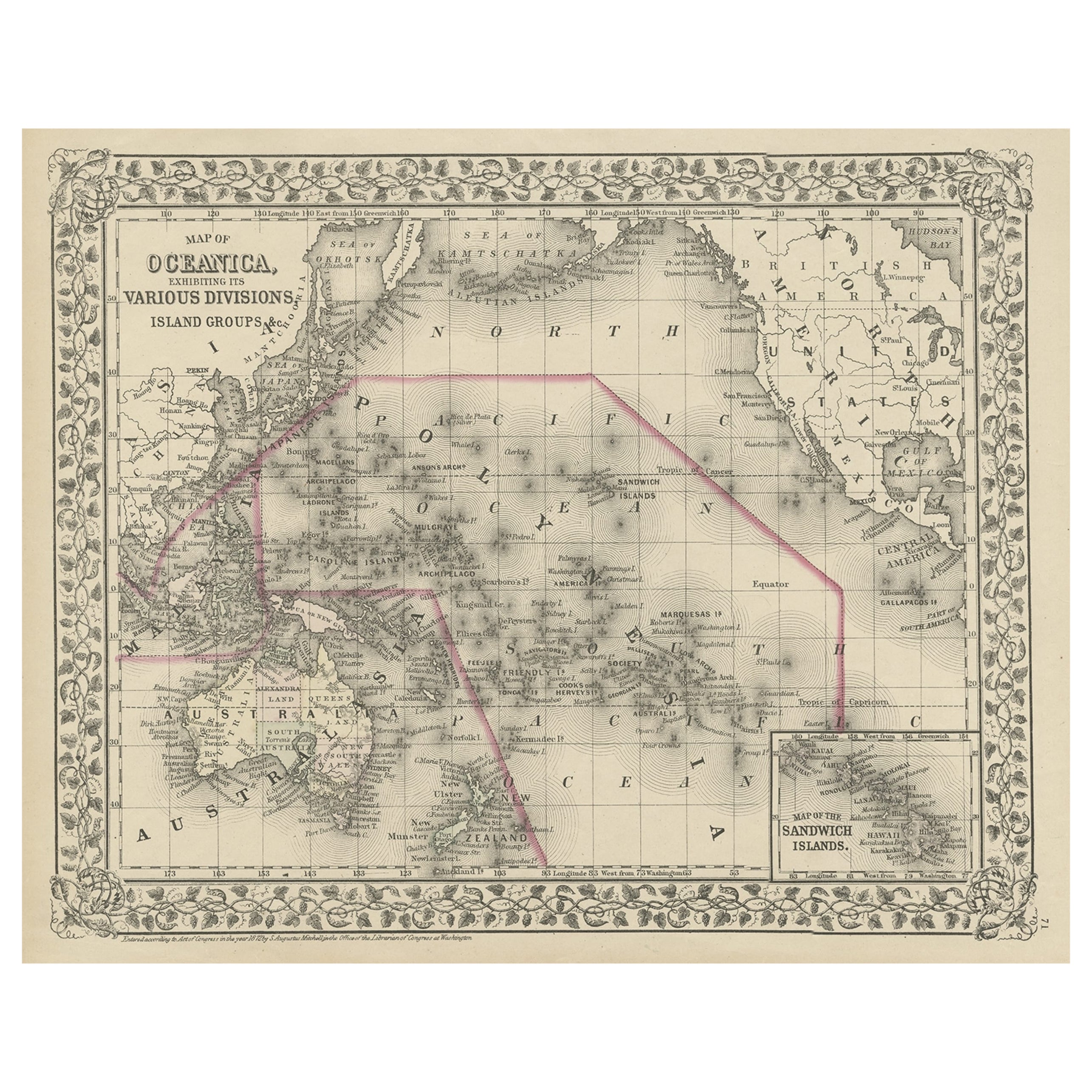
The image is an antique map, a two-page spread from "Johnson's New Illustrated Family Atlas of the World," by A.J. Johnson, dated 1872. This particular map offers a depiction of Sweden and Norway on one page, and Denmark along with the duchies of Schleswig and Holstein on the other, both set within an ornate border that is characteristic of Johnson’s atlas designs.
The map of Sweden and Norway shows the two countries occupying the Scandinavian Peninsula, with a clear delineation between them. The map is color-coded, likely to indicate political boundaries, with Norway to the west in a single color and Sweden to the east in another. Fjords and mountainous terrain are depicted in Norway, and major rivers and lakes are visible in Sweden. The cities and towns are marked, possibly with size indicating their importance or population.
Denmark, on the right, is shown with its mainland Jutland peninsula and numerous islands. The duchies of Schleswig (Sleswick) and Holstein are located at the southern part of the Jutland peninsula, and they are detailed with different colorings, which may reflect their contentious political status at the time. The map includes detailed coastal lines, town dots, and possibly the rail network of that era.
A.J. Johnson’s atlases are known for their accuracy and beauty and were considered some of the finest American atlases produced in the 19th century. The cartography would be based on the best available knowledge of the time, and this map would serve not only as a practical reference but also as an educational tool for families. The visual appeal and the inclusion of geographic and political information make it a valuable historical document, reflecting the understanding and representation of these Northern European regions in the late 19th century.
- Dimensions:Height: 18.12 in (46 cm)Width: 26.38 in (67 cm)Depth: 0.02 in (0.5 mm)
- Materials and Techniques:
- Period:
- Date of Manufacture:1872
- Condition:General age-related toning, shows minor wear and creasing. Some soiling. Original folding line. English text on verso. Please study images carefully.
- Seller Location:Langweer, NL
- Reference Number:Seller: BG-12592-301stDibs: LU3054321466812
About the Seller
5.0
Platinum Seller
These expertly vetted sellers are 1stDibs' most experienced sellers and are rated highest by our customers.
Established in 2009
1stDibs seller since 2017
1,929 sales on 1stDibs
Typical response time: <1 hour
- ShippingRetrieving quote...Ships From: Langweer, Netherlands
- Return PolicyA return for this item may be initiated within 14 days of delivery.
Auctions on 1stDibs
Our timed auctions are an opportunity to bid on extraordinary design. We do not charge a Buyer's Premium and shipping is facilitated by 1stDibs and/or the seller. Plus, all auction purchases are covered by our comprehensive Buyer Protection. Learn More
More From This SellerView All
- Antique Map of Asia by Johnson, 1872Located in Langweer, NLAntique map titled 'Johnson's Asia'. Original map of Asia. This map originates from 'Johnson's New Illustrated Family Atlas of the World' by A.J. Johnson. Published, 1872.Category
Antique Late 19th Century Maps
MaterialsPaper
- Antique Map of Indiana by Johnson, 1872Located in Langweer, NLAntique map titled 'Johnson's Indiana'. Original map of Indiana. This map originates from 'Johnson's New Illustrated Family Atlas of the World' by A.J. ...Category
Antique Late 19th Century Maps
MaterialsPaper
- Antique Map of Europe by Johnson, '1872'Located in Langweer, NLAntique map titled 'Johnson's Europe'. Original map of Europe. This map originates from 'Johnson's New Illustrated Family Atlas of the World' by A.J. Johnson. Published 1872.Category
Antique Late 19th Century Maps
MaterialsPaper
- Antique Map of Illinois by Johnson, 1872Located in Langweer, NLAntique map titled 'Johnson's Illinois'. Original map of Illinois. This map originates from 'Johnson's New Illustrated Family Atlas of the World' by A....Category
Antique Late 19th Century Maps
MaterialsPaper
- Antique Map of China and Japan by Johnson, 1872Located in Langweer, NLAntique map titled 'Johnson's China and Japan'. Map of China and Japan, with an inset map of the vicinity of Canton and Hong Kong. This map originates from 'Johnson's New Illustrated...Category
Antique Late 19th Century Maps
MaterialsPaper
- Antique Map of Prussia and Germany by Johnson, 1872Located in Langweer, NLAntique map titled 'Johnson's Prussia and Germany (..)'. Original map of Prussia and Germany, with inset map of North Eastern Prussia. This map originates from 'Johnson's New Illustr...Category
Antique Late 19th Century Maps
MaterialsPaper


You May Also Like
- Antique Map of Italy by Andriveau-Goujon, 1843By Andriveau-GoujonLocated in New York, NYAntique Map of Italy by Andriveau-Goujon, 1843. Map of Italy in two parts by Andriveau-Goujon for the Library of Prince Carini at Palazzo Carini i...Category
Antique 1840s French Maps
MaterialsLinen, Paper
- Antique Map of Principality of MonacoBy Antonio Vallardi EditoreLocated in Alessandria, PiemonteST/619 - "Old Geographical Atlas of Italy - Topographic map of ex-Principality of Monaco" - ediz Vallardi - Milano - A somewhat special edition ---Category
Antique Late 19th Century Italian Other Prints
MaterialsPaper
- Sweden & Adjacent Portions of Scandinavia: A Hand-Colored 18th C. Map by HomannBy Johann Baptist HomannLocated in Alamo, CAThis hand-colored map of Sweden and adjacent portions of Scandinavia entitled "Regni Sueciae in Omnes suas Subjacentes Provincias accurate divisi Tabula Generalis" was created by Joh...Category
Antique 1720s German Maps
MaterialsPaper
- 17th Century Map of Denmark by French Cartographer Sanson, Dated 1658By Nicolas SansonLocated in Copenhagen, K17th century map of Denmark by French cartographer Sanson. Nicolas Sanson (20 December 1600-7 July 1667) was a French cartographer, termed by some the creator of French geography an...Category
Antique 17th Century French Maps
MaterialsPaper
- Large Antique 1859 Map of North AmericaLocated in Sag Harbor, NYThis Map was made by Augustus Mitchell in 1859 It is in amazing condition for being 163 years old. This price is for the rolled up easy to ship version of this piece. I will be Frami...Category
Antique Mid-19th Century American Maps
MaterialsCanvas, Paper

- Hand-Colored 18th Century Homann Map of Denmark and Islands in the Baltic SeaBy Johann Baptist HomannLocated in Alamo, CAAn 18th century copper plate hand-colored map entitled "Insulae Danicae in Mari Balthico Sitae utpote Zeelandia, Fionia, Langelandia, Lalandia, Falstria, Fembria Mona" created by Joh...Category
Antique Early 18th Century German Maps
MaterialsPaper


Recently Viewed
View AllMore Ways To Browse
New World Map
New World Maps
Swedish And Danish Antiques
Antique Norwegian
Norwegian Antique
Antique Norwegian Furniture
Norwegian Antique Furniture
19th Norwegian
Norway 19th Century
19th Century Norwegian
Antique Norway
19th Century Norwegian Furniture
Denmark Maps
Denmark Map
Norwegian Antiques
Norway Map
Map Of Sweden
Map Sweden