Items Similar to Antique Geological Map of the World by Johnston '1850'


Want more images or videos?
Request additional images or videos from the seller
1 of 5
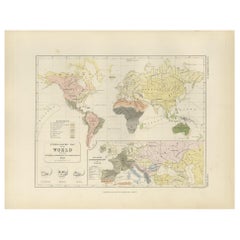
Antique Geological Map of the World by Johnston '1850'
About the Item
Antique map titled 'The Geological Structure of the Globe'. Original antique geological map of the world. This map originates from 'The Physical Atlas of Natural Phenomena' by A.K. Johnston, published 1850.
- Dimensions:Height: 11.03 in (28 cm)Width: 14.18 in (36 cm)Depth: 0.02 in (0.5 mm)
- Materials and Techniques:
- Period:
- Date of Manufacture:1850
- Condition:General age-related toning. Minor wear, blank verso. Please study image carefully.
- Seller Location:Langweer, NL
- Reference Number:
About the Seller
5.0
Platinum Seller
These expertly vetted sellers are 1stDibs' most experienced sellers and are rated highest by our customers.
Established in 2009
1stDibs seller since 2017
1,916 sales on 1stDibs
Typical response time: <1 hour
- ShippingRetrieving quote...Ships From: Langweer, Netherlands
- Return PolicyA return for this item may be initiated within 14 days of delivery.
More From This SellerView All
- Antique Rain Map of the World by Johnston '1850'Located in Langweer, NLAntique map titled 'Hyetographic or Rain Map of the World'. Original antique rain map of the world. This map originates from 'The Physical Atlas of Natural Phenomena' by A.K. Johnsto...Category
Antique Mid-19th Century Maps
MaterialsPaper
- Antique Ethnographic Map of the World by Johnston '1850'Located in Langweer, NLAntique map titled 'Ethnographic map of the world showing the present distribution of the leading races of man'. Original antique ethnographic map...Category
Antique Mid-19th Century Maps
MaterialsPaper
- Antique Map showing Isotherm Lines throughout the World by Johnston '1850'Located in Langweer, NLAntique map titled 'Humboldt's System of Isothermal Lines'. Original antique map showing isotherm lines throughout the world. This map originates from 'The Physical Atlas of Natural ...Category
Antique Mid-19th Century Maps
MaterialsPaper
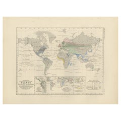
- Antique Map Showing the Distribution of Plants by Johnston, '1850'Located in Langweer, NLAntique map titled 'Geographical Distribution of Plants'. Original antique map showing the distribution of plants. This map originates from 'The Physical Atlas of Natural Phenomena' ...Category
Antique Mid-19th Century Maps
MaterialsPaper
- Antique Map Showing the Distribution of Plants by Johnston '1850'Located in Langweer, NLAntique map titled 'Geographical plants which are used as food for man'. Original antique map showing the distribution of plants. This map originates from 'The Physical Atlas of Natu...Category
Antique Mid-19th Century Maps
MaterialsPaper
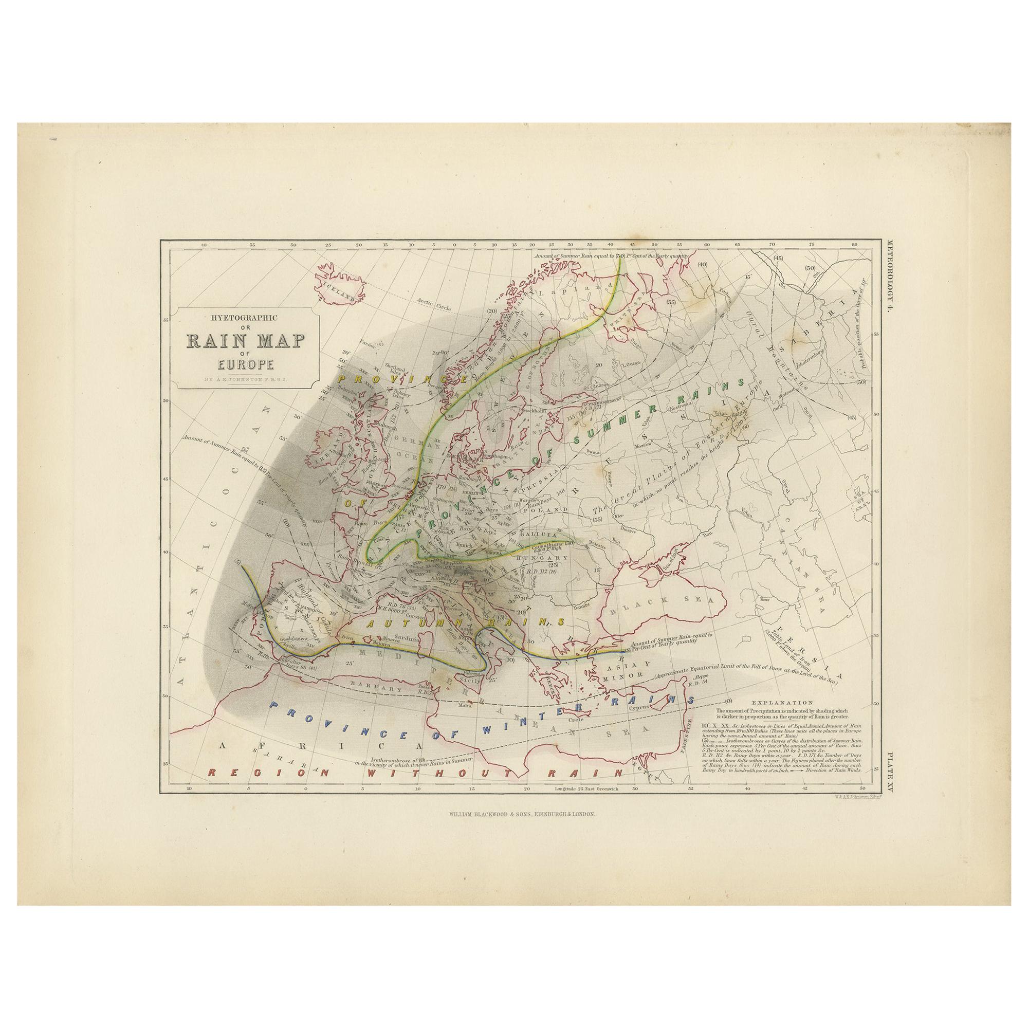
- Antique Rain Map of Europe by Johnston '1850'Located in Langweer, NLAntique map titled 'Hyetographic or Rain Map of Europe'. Original antique rain map of Europe. This map originates from 'The Physical Atlas of Natural Phenomena' by A.K. Johnston, pub...Category
Antique Mid-19th Century Maps
MaterialsPaper


You May Also Like
- Original Antique Map of The World by Thomas Clerk, 1817Located in St Annes, LancashireGreat map of The Eastern and Western Hemispheres On 2 sheets Copper-plate engraving Drawn and engraved by Thomas Clerk, Edinburgh. Published by Mackenzie And Dent, 1817 ...Category
Antique 1810s English Maps
MaterialsPaper
- Original Antique Map of Belgium by Tallis, Circa 1850Located in St Annes, LancashireGreat map of Belgium Steel engraving Many lovely vignettes Published by London Printing & Publishing Co. ( Formerly Tallis ), C.1850 Origin...Category
Antique 1850s English Maps
MaterialsPaper
- Antique 1901 National Publishing Company's Road Map of New Jersey GeologicalLocated in Dayton, OHThe National Publishing Company's road map of New Jersey, showing all county and township divisions, cities villages and post-offices, railroads, ste...Category
Antique Early 1900s Victorian Prints
MaterialsPaper
- Original Antique Map / City Plan of Brussels by Tallis, circa 1850Located in St Annes, LancashireGreat map of Brussels. Steel engraving. Published by London Printing & Publishing Co. (Formerly Tallis), C.1850 Free shipping.Category
Antique 1850s English Maps
MaterialsPaper
- Original Antique Map of The Netherlands, Engraved by Barlow, Dated 1807Located in St Annes, LancashireGreat map of Netherlands Copper-plate engraving by Barlow Published by Brightly & Kinnersly, Bungay, Suffolk. Dated 1807 Unframed.Category
Antique Early 1800s English Maps
MaterialsPaper
- Map of the Republic of GenoaLocated in New York, NYFramed antique hand-coloured map of the Republic of Genoa including the duchies of Mantua, Modena, and Parma. Europe, late 18th century. Dimension: 25...Category
Antique Late 18th Century European Maps


Recently Viewed
View AllMore Ways To Browse
Antique Globes Of The World
Used World Globes
Antique World Maps And Atlases World Maps
19th Century World Map
Globe Map
Map Globe
Antique World Globe
Antique World Globes
World Globes Antique
Mid Century Globe World
Antique Globes And Maps
Antique Maps And Globes
Antique Paper Globe
World Map Globe
Antique Map Globe
Atlas Globe
Antique Geology
Antique World Globe Map