Items Similar to 1861 Topographical Map of the District of Columbia, by Boschke, Antique Map


Want more images or videos?
Request additional images or videos from the seller
1 of 5
1861 Topographical Map of the District of Columbia, by Boschke, Antique Map
About the Item
Presented is an original map of Albert Boschke's extremely sought-after "Topographical Map of the District of Columbia Surveyed in the Years 1856 '57 '58 & '59" from 1861. The map was published out of Washington D.C. by D. McClelland, Blanchard and Mohun. Boschke’s map is known for its highly accurate details. Drawn on a scale of four inches to a mile, the map documented the location of all buildings in the city, both private and public, with each structure drawn from tape-line measurements that had been made in the field. The roads were measured by two parties, one with transit and chain, the other with a level. Roads, rivers, creeks, farm and wooded lands are named on the map, along with property lines and landowner names. The map also includes accurate topographical details. The map was drawn and engraved in the style of the charts issued by the U.S. Coast and Geodetic Survey.
Albert Boschke was a civil engineer who worked for the U.S. Coast and Geodetic Survey in Washington, D.C. His name began to appear on official surveys that he had produced by the early to mid-1850s. Boschke conceived the idea of making a highly accurate map of Washington and of the District of Columbia with the hope of selling it to the government. At his own expense, Boschke organized and employed surveyors to do the fieldwork for the survey. This project eventually cost him his job at the Coast Survey. After 5 years, the project yielded two maps, a large four sheet map of the city in 1857 and this highly detailed map of the whole District of Columbia in 1861.
At the outbreak of the Civil War, Boschke’s survey was the only topographic map to exist of the District of Columbia in its entirety. Boschke sold his interest in the map to engravers. McClelland engraved the Boschke map and executed the work on two plates. The elaborate details and large size of the map meant that the work was painstaking and lengthy. Upon completion, McClelland pitched the survey to the United States government for $20,000. Secretary Stanton, not estimating the extensive labor and expense involved in completing the map, offered to purchase it for a mere $500. McClelland and his partners counter-offered the copper-plates and manuscript to the government for $4,000, on condition that the plates with the copyright should be returned to them at the close of the war. This offer was also refused.
After such disagreements, the U.S. Secretary of War ordered the seizing of all material relating to this map. The war was still going on and the necessity for a detailed topographical survey of the area was apparent. However, before the materials were seized, McClelland ordered for further conference to discuss a reasonable price. Secretary Stanton suggested a payment of $8,500 and the offer was ultimately accepted.
The complexities of Boschke's map and the story of its seizure has rendered it very scarce on the market. Original examples are very rare and highly sought-after among collectors.
Condition:
Overall very good condition considering age. Significant crease in center where sheets are joined, scattered holes and light staining, but overall a very stabile and clear example. Framed according to the highest conservation standards.
- Dimensions:Height: 53.25 in (135.26 cm)Width: 53.75 in (136.53 cm)Depth: 3.5 in (8.89 cm)
- Materials and Techniques:
- Place of Origin:
- Period:
- Date of Manufacture:1861
- Condition:Wear consistent with age and use. Overall very good condition considering age. Significant crease in center where sheets are joined, scattered holes and light staining, but overall a very stabile and clear example. Framed according to the highest conservation standards.
- Seller Location:Colorado Springs, CO
- Reference Number:
About the Seller
4.9
Platinum Seller
These expertly vetted sellers are 1stDibs' most experienced sellers and are rated highest by our customers.
Established in 2010
1stDibs seller since 2011
400 sales on 1stDibs
Typical response time: <1 hour
- ShippingRetrieving quote...Ships From: Colorado Springs, CO
- Return PolicyA return for this item may be initiated within 10 days of delivery.
More From This SellerView All
- 1907 Map of Colorado, Antique Topographical Map, by Louis NellLocated in Colorado Springs, COThis highly detailed pocket map is a topographical map of the state of Colorado by Louis Nell from 1907. The map "has been complied from all availabl...Category
Antique Early 1900s American Maps
MaterialsPaper
- 1812 United States Map, by Pierre Tardieu, Antique French Map Depicting the U.S.By Pierre François TardieuLocated in Colorado Springs, CO1812 "United States of Nth America -- Carte des Etats-Unis De L'Amerique Septentrionale" Two-Sheet Map by Tardieu This attractive map, published in Paris in 1812, is one of the most rare large format maps from the period. It features a view of the East Coast of the U.S. from Maryland to just below South Carolina. Additionally, Ellicott’s plan for the City of Washington D.C. is included at the top right and an illustration of Niagara Falls is shown at the bottom right with a description in both French and English. This extremely detailed map not only depicts the mountainous regions of the southeastern U.S., but also includes names of regions, rivers, and towns. Based on the first state of Arrowsmith’s 4-sheet map of the United States, this map is completely engraved by Tardieu in Paris and showcases high quality engravings. This detailed map of the recently independent United States includes one of the largest and earliest examples of the Ellicott plan of Washington DC. The artist, Pierre François Tardieu (PF Tardieu) was a very well-known map engraver, geographer, and illustrator. Awarded a bronze medal by King Louis-Phillipe for the accuracy and beauty of his map-making, Tardieu produced many fine works including maps of Louisiana...Category
Antique 1810s French Maps
MaterialsPaper
- "Clason's Guide Map of Montana" by The Clason Map Company, Circa 1920sLocated in Colorado Springs, COPresented is “Clason's Guide Map of Montana,” published in the early 1920s by the Clason Map Company. Issued as a folding map, this map identifies county boundaries, county seats, Na...Category
Vintage 1920s American Art Deco Maps
MaterialsPaper
- 1908 "Map of Texas" by The Kenyon CompanyLocated in Colorado Springs, COPresented is an antique map of the state of Texas, printed as a pocket map in 1908 by The Kenyon Company. The state map is brightly colored by county, with principal cities and towns listed. The congressional districts are numbered and boldly outlined in red. Rivers, roads, and railroads all appear prominently on this fantastic map...Category
Antique Early 1900s American Maps
MaterialsPaper
- 1859 "Map of the United States of America..." by J. H. ColtonBy J.H. ColtonLocated in Colorado Springs, COPresented is an 1859 “Map of the United States of America, the British Provinces, Mexico, the West Indies and Central America with Part of...Category
Antique 1850s American Maps
MaterialsPaper
- 1864 Map of North America, Antique Hand-Colored Map, by Adolphe Hippolyte DufourLocated in Colorado Springs, COOffered is a map of North America entitled Amerique du Nord from 1864. This rare, separately published wall map was produced by Adolphe Hippolyte Dufour. This map includes vibrant an...Category
Antique 1860s French Maps
MaterialsPaper


You May Also Like
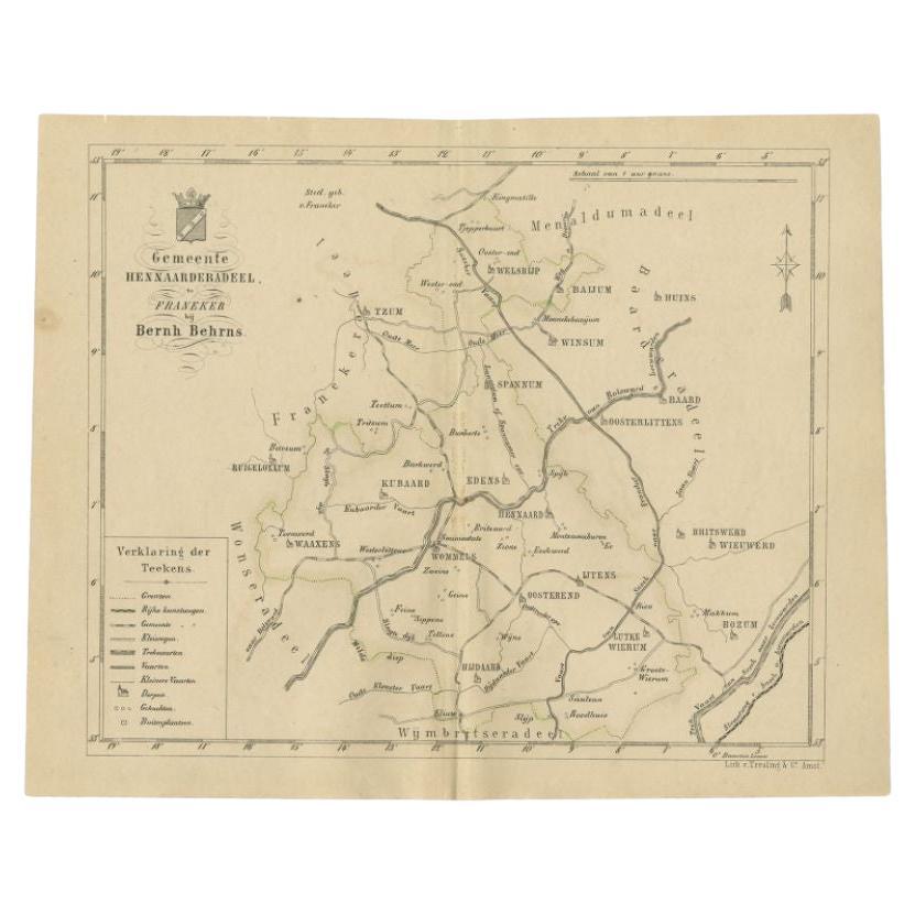
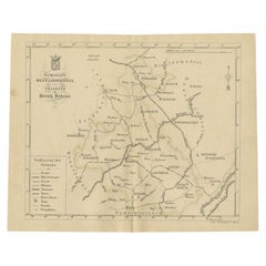
- Antique Map of the Hennaarderadeel Township by Behrns, 1861Located in Langweer, NLAntique map titled 'Gemeente Hennaarderadeel'. Old map depicting the Hennaarderadeel township including cities and villages like Kubaard, Wommels, Hennaard, Oosterend, Wierum, Tzum, ...Category
Antique 19th Century Maps
MaterialsPaper
- Antique Map of the Lemsterland Township by Behrns, 1861Located in Langweer, NLAntique map titled 'Gemeente Lemsterland'. Old map depicting the Lemsterland township including cities and villages like Lemmer, Follega, Oosterzee en Echten. This map orginates from...Category
Antique 19th Century Maps
MaterialsPaper
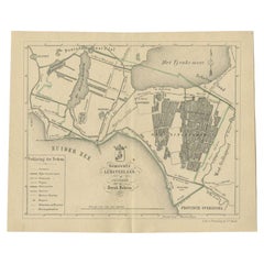
- Antique Map of the Leeuwarderadeel Township by Behrns, 1861Located in Langweer, NLAntique map titled 'Gemeente Leeuwarderadeel'. Old map depicting the Leeuwarderadeel township including cities and villages like Finkum, Hijum, Stiens, Jelsum, Leeuwarden, Wirdum and...Category
Antique 19th Century Maps
MaterialsPaper
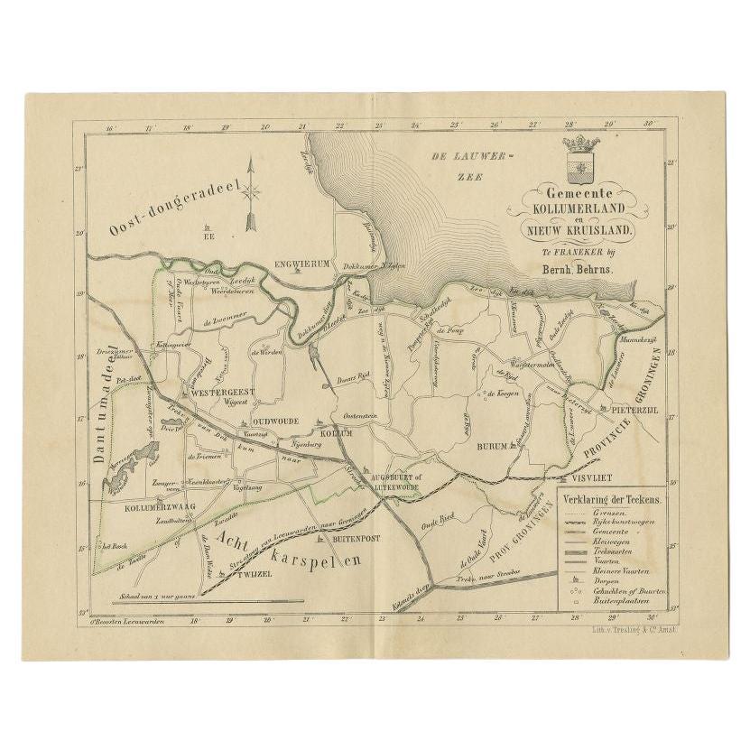
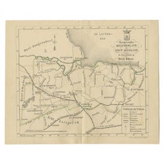
- Antique Map of the Kollumerland Township by Behrns, 1861Located in Langweer, NLAntique map titled 'Gemeente Kollumerland en Nieuw Kruisland'. Old map depicting the Kollumerland township including cities and villages like Westergeest, Kollum, Kollumerzwaag and B...Category
Antique 19th Century Maps
MaterialsPaper
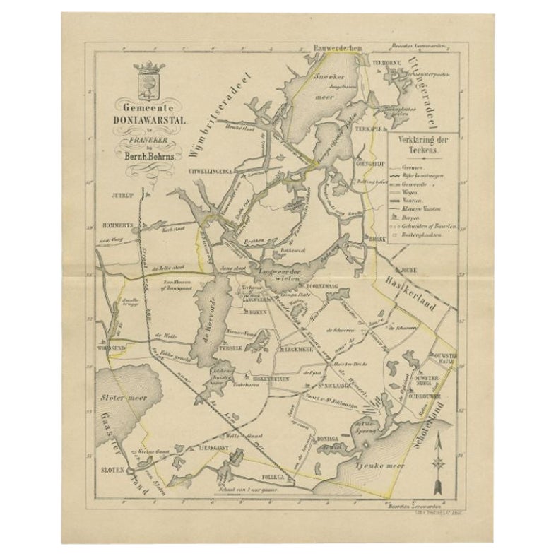
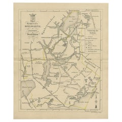
- Antique Map of the Doniawerstal Township by Behrns, 1861Located in Langweer, NLAntique map titled 'Gemeente Doniawerstal'. Old map depicting the Doniawerstal township including cities and villages like Follega, Tjerkgaast, Legemeer, Idskenhuizen, St. Nicolaasga...Category
Antique 19th Century Maps
MaterialsPaper
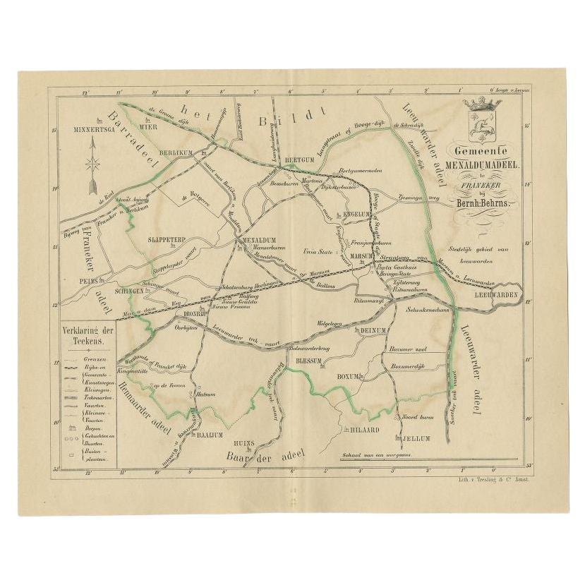
- Antique Map of the Menaldumadeel Township by Behrns, 1861Located in Langweer, NLAntique map titled 'Gemeente Menaldumadeel'. Old map depicting the Menaldumadeel township including cities and villages like Berlikum, Wier, Menaldum, Dronrijp, Marsum, Engelum, Dein...Category
Antique 19th Century Maps
MaterialsPaper

Recently Viewed
View AllMore Ways To Browse
Antique Historical Maps
Civil War Antiques
Columbia Used Furniture
Antique War Memorabilia
Washington Antiques
United States Government
Antique Survey
Framed Map United States
Large Scale Map
Topographical Map
Historical Documents
Large Stabile
U S Map
Antique Conference
Antique Albert Chain
Antique Albert Chains
Washington Map
Antique War Maps